Bridge Statistics for Bellevue, Illinois (IL)
Condition, Traffic, Stress, Structural Evaluation, Project Costs
- National Bridge Inventory (NBI) Statistics
- 26Number of bridges
- 367ft / 112mTotal length
- 318,550Total average daily traffic
- 34,753Total average daily truck traffic
- National Bridge Inventory (NBI) Registered Bridges for Bellevue
- No street view available for this location
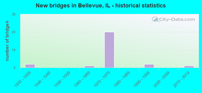
- New bridges - historical statistics
- 21930-1939
- 11960-1969
- 201970-1979
- 21990-1999
- 12010-2019

- Reconstructed bridges - Historical Statistics
- 11980-1989
- 01990-1999
- 22000-2009


- Bridge Condition - Deck
- 6.7%Satisfactory
- 80.0%Fair
- 6.7%Poor
- 6.7%Serious

- Bridge Condition - Superstructure
- 6.3%Good
- 18.8%Satisfactory
- 37.5%Fair
- 18.8%Poor
- 12.5%Serious
- 6.3%Critical

- Bridge Condition - Substructure
- 25.0%Good
- 18.8%Satisfactory
- 43.8%Fair
- 6.3%Poor
- 6.3%Serious

- Bridge Condition - Channel
- 25.0%Very good
- 25.0%Good
- 50.0%Fair
Find on map >> Show street view
Structure Number: 720037, Location: HARMON HIGHWAY (Lat: 40.681231, Lng: -89.656150), Route carried "on" structure: State highway 116, Year Built: 1935, Year Reconstructed: 1988, Status: Temporarily open, Structure Length: 19.45m (63.81ft), Average Daily Traffic: 7,250 (year 2021), Truck Traffic: 4%, Average Future Daily Traffic: 11,045 (year 2032), Design Load: HS 15, Features Intersected: BNSF & UPRR KICKAPOO
Minimum Vertical Clearance: 30+ m (98+ ft), Kilometerpoint: 121.068, Lanes on structure: 4, Lanes under structure: 2, Base Highway Network: Yes, Owner: State Highway Agency, Approaching Roadway Width: 15.8m (51.8ft), Skew: 21 degrees, Material/Design: Steel, Design/Construction: Truss - Deck, Number Of Spans In Main Unit: 1, Number Of Approach Spans: 10, Length of Maximum Span: 42.4m (139.1ft), Curb-To-Curb Width: 18.0m (59.1ft), Out-to-Out Width: 18.9m (62.0ft)
Condition: Deck: Fair, Superstructure: Critical, Substructure: Serious, Channel: Good, Structural Evaluation: High priority of replacement, Deck Geometry: Somewhat better than minimum adequacy, Underclear: Superior to present desirable criteria, Waterway Adequacy: Superior to present desirable criteria, Approach Roadway Alignment: Equal to present desirable criteria, Designated Inspection Frequency: Every 12 months, Critical Feature Inspection Frequency: Every 12 months, Other Special Inspection Frequency: Every 6 months, Inspection Date: August 2021, Critical Feature Inspection Date: August 2021, Other Special Inspection Date: August 2021, Deck Structure Type: Concrete Cast-file-Place, Wearing Surface/Protective System: Deck Protection: Epoxy Coated Reinforcing
Find on map >> Show street view
Structure Number: 720116, Location: SW1/4 35 KICKAPOO (Lat: 40.718200, Lng: -89.676539), Route carried "on" structure: Interstate 474, Year Built: 1978, Status: Open, Structure Length: 3.93m (12.89ft), Average Daily Traffic: 16,800 (year 2021), Truck Traffic: 11%, Average Future Daily Traffic: 17,204 (year 2032), Design Load: HS 20+Mod, Features Intersected: TR 173 Pottstown Rd
Minimum Vertical Clearance: 30+ m (98+ ft), Kilometerpoint: 3.380, Lanes on structure: 2, Lanes under structure: 2, Base Highway Network: Yes, Owner: State Highway Agency, Approaching Roadway Width: 12.8m (42.0ft), Material/Design: Prestressed concrete, Design/Construction: Stringer/Multi-beam, Number Of Spans In Main Unit: 3, Length of Maximum Span: 14.0m (45.9ft), Curb-To-Curb Width: 11.7m (38.4ft), Out-to-Out Width: 12.8m (42.0ft)
Condition: Deck: Fair, Superstructure: Fair, Substructure: Satisfactory, Operating Rating: 71.9 metric tons, Method Used To Determine Operating Rating: Load Factor (LF) rating reported by rating factor (RF) method using MS18 loading, Inventory Rating: 34.0 metric tons, Method Used To Determine Inventory Rating: Load Factor (LF) rating reported by rating factor (RF) method using MS18 loading, Structural Evaluation: Somewhat better than minimum adequacy, Deck Geometry: Equal to present minimum criteria, Underclear: Better than present minimum criteria, Approach Roadway Alignment: Equal to present desirable criteria, Designated Inspection Frequency: Every 24 months, Inspection Date: December 2020, Deck Structure Type: Concrete Cast-file-Place, Wearing Surface/Protective System: Wearing Surface: Bituminous, Membrane: Built-up
Find on map >> Show street view
Structure Number: 720117, Location: SW 1/4 35 KICKAPOO (Lat: 40.718017, Lng: -89.676536), Route carried "on" structure: Interstate 474, Year Built: 1978, Status: Open, Structure Length: 3.44m (11.29ft), Average Daily Traffic: 16,800 (year 2021), Truck Traffic: 11%, Average Future Daily Traffic: 17,204 (year 2032), Design Load: HS 20+Mod, Features Intersected: TR 173 Pottstown Rd
Minimum Vertical Clearance: 30+ m (98+ ft), Kilometerpoint: 3.396, Lanes on structure: 2, Lanes under structure: 2, Base Highway Network: Yes, Owner: State Highway Agency, Approaching Roadway Width: 12.8m (42.0ft), Material/Design: Prestressed concrete, Design/Construction: Stringer/Multi-beam, Number Of Spans In Main Unit: 3, Length of Maximum Span: 14.0m (45.9ft), Curb-To-Curb Width: 11.7m (38.4ft), Out-to-Out Width: 12.8m (42.0ft)
Condition: Deck: Fair, Superstructure: Fair, Substructure: Satisfactory, Operating Rating: 71.9 metric tons, Method Used To Determine Operating Rating: Load Factor (LF) rating reported by rating factor (RF) method using MS18 loading, Inventory Rating: 34.0 metric tons, Method Used To Determine Inventory Rating: Load Factor (LF) rating reported by rating factor (RF) method using MS18 loading, Structural Evaluation: Somewhat better than minimum adequacy, Deck Geometry: Equal to present minimum criteria, Underclear: Better than present minimum criteria, Approach Roadway Alignment: Equal to present desirable criteria, Designated Inspection Frequency: Every 24 months, Inspection Date: December 2020, Deck Structure Type: Concrete Cast-file-Place, Wearing Surface/Protective System: Wearing Surface: Bituminous, Membrane: Built-up
Find on map >> Show street view
Structure Number: 720118, Location: .1 MI E COUNTRY LANE (Lat: 40.698242, Lng: -89.676436), Route carried "on" structure: Other road , Year Built: 1974, Status: Open, Structure Length: 8.23m (27.00ft), Average Daily Traffic: 5,500 (year 2017), Truck Traffic: 6%, Average Future Daily Traffic: 6,372 (year 2032), Design Load: HS 20, Features Intersected: I-474, Facility Carried by Structure: FARMINGTON RD
Minimum Vertical Clearance: 30+ m (98+ ft), Kilometerpoint: 3.653, Lanes on structure: 2, Lanes under structure: 4, Base Highway Network: Yes, Owner: State Highway Agency, Approaching Roadway Width: 13.4m (44.0ft), Skew: 1 degrees, Material/Design: Steel continuous, Design/Construction: Stringer/Multi-beam, Number Of Spans In Main Unit: 2, Number Of Approach Spans: 2, Length of Maximum Span: 30.5m (100.1ft), Curb-To-Curb Width: 12.9m (42.3ft), Out-to-Out Width: 14.0m (45.9ft)
Condition: Deck: Fair, Superstructure: Fair, Substructure: Fair, Operating Rating: 40.2 metric tons, Method Used To Determine Operating Rating: Load Factor (LF) rating reported by rating factor (RF) method using MS18 loading, Inventory Rating: 24.0 metric tons, Method Used To Determine Inventory Rating: Load Factor (LF) rating reported by rating factor (RF) method using MS18 loading, Structural Evaluation: Somewhat better than minimum adequacy, Deck Geometry: Somewhat better than minimum adequacy, Underclear: Equal to present minimum criteria, Approach Roadway Alignment: Equal to present desirable criteria, Designated Inspection Frequency: Every 24 months, Inspection Date: January 2021, Deck Structure Type: Concrete Cast-file-Place, Wearing Surface/Protective System: Wearing Surface: Latex Concrete
Find on map >> Show street view
Structure Number: 720119, Location: 1/2M NORTH BELLEVUE (Lat: 40.693872, Lng: -89.676194), Route carried "on" structure: Other road , Year Built: 1978, Year Reconstructed: 2013, Status: Open, Structure Length: 8.41m (27.59ft), Average Daily Traffic: 8,850 (year 2017), Truck Traffic: 7%, Average Future Daily Traffic: 5,045 (year 2032), Design Load: HS 20, Features Intersected: I-474, Facility Carried by Structure: FAP 671 SPUR EB
Minimum Vertical Clearance: 30+ m (98+ ft), Kilometerpoint: 2.124, Lanes on structure: 2, Lanes under structure: 4, Base Highway Network: Yes, Owner: State Highway Agency, Approaching Roadway Width: 12.2m (40.0ft), Material/Design: Steel continuous, Design/Construction: Stringer/Multi-beam, Number Of Spans In Main Unit: 2, Number Of Approach Spans: 2, Length of Maximum Span: 29.9m (98.1ft), Curb-To-Curb Width: 16.0m (52.5ft), Out-to-Out Width: 16.6m (54.5ft)
Condition: Deck: Fair, Superstructure: Fair, Substructure: Good, Operating Rating: 66.7 metric tons, Method Used To Determine Operating Rating: Load Factor (LF) rating reported by rating factor (RF) method using MS18 loading, Inventory Rating: 39.9 metric tons, Method Used To Determine Inventory Rating: Load Factor (LF) rating reported by rating factor (RF) method using MS18 loading, Structural Evaluation: Somewhat better than minimum adequacy, Deck Geometry: Superior to present desirable criteria, Underclear: Better than present minimum criteria, Approach Roadway Alignment: Equal to present desirable criteria, Designated Inspection Frequency: Every 24 months, Inspection Date: May 2020, Deck Structure Type: Concrete Cast-file-Place, Wearing Surface/Protective System: Deck Protection: Epoxy Coated Reinforcing
Find on map >> Show street view
Structure Number: 72012, Location: 0.5M NORTH BELLEVUE (Lat: 40.693872, Lng: -89.676356), Route carried "on" structure: Other road , Year Built: 1978, Year Reconstructed: 2013, Status: Open, Structure Length: 8.11m (26.61ft), Average Daily Traffic: 8,850 (year 2017), Truck Traffic: 7%, Average Future Daily Traffic: 5,045 (year 2032), Design Load: HS 20, Features Intersected: I-474, Facility Carried by Structure: FAP 671 SPUR WB
Minimum Vertical Clearance: 30+ m (98+ ft), Kilometerpoint: 2.108, Lanes on structure: 2, Lanes under structure: 4, Base Highway Network: Yes, Owner: State Highway Agency, Approaching Roadway Width: 12.2m (40.0ft), Material/Design: Steel continuous, Design/Construction: Stringer/Multi-beam, Number Of Spans In Main Unit: 2, Number Of Approach Spans: 2, Length of Maximum Span: 29.9m (98.1ft), Curb-To-Curb Width: 16.3m (53.5ft), Out-to-Out Width: 17.4m (57.1ft)
Condition: Deck: Fair, Superstructure: Fair, Substructure: Good, Operating Rating: 75.5 metric tons, Method Used To Determine Operating Rating: Load Factor (LF) rating reported by rating factor (RF) method using MS18 loading, Inventory Rating: 45.0 metric tons, Method Used To Determine Inventory Rating: Load Factor (LF) rating reported by rating factor (RF) method using MS18 loading, Structural Evaluation: Somewhat better than minimum adequacy, Deck Geometry: Superior to present desirable criteria, Underclear: Equal to present minimum criteria, Approach Roadway Alignment: Equal to present desirable criteria, Designated Inspection Frequency: Every 24 months, Inspection Date: May 2020, Deck Structure Type: Concrete Cast-file-Place, Wearing Surface/Protective System: Deck Protection: Epoxy Coated Reinforcing
Find on map >> Show street view
Structure Number: 720121, Location: 0.3M E OF MAIN ST (Lat: 40.688361, Lng: -89.675719), Route carried "on" structure: Interstate 474, Year Built: 1972, Status: Open, Structure Length: 5.73m (18.80ft), Average Daily Traffic: 14,800 (year 2021), Truck Traffic: 13%, Average Future Daily Traffic: 15,187 (year 2032), Design Load: HS 20+Mod, Features Intersected: IL 116
Minimum Vertical Clearance: 30+ m (98+ ft), Kilometerpoint: 6.695, Lanes on structure: 2, Lanes under structure: 2, Base Highway Network: Yes, Owner: State Highway Agency, Approaching Roadway Width: 12.2m (40.0ft), Skew: 2 degrees, Material/Design: Steel, Design/Construction: Stringer/Multi-beam, Number Of Spans In Main Unit: 1, Number Of Approach Spans: 2, Length of Maximum Span: 37.8m (124.0ft), Curb-To-Curb Width: 12.2m (40.0ft), Out-to-Out Width: 13.4m (44.0ft)
Condition: Deck: Fair, Superstructure: Poor, Substructure: Fair, Operating Rating: 43.1 metric tons, Method Used To Determine Operating Rating: Load Factor (LF) rating reported by rating factor (RF) method using MS18 loading, Inventory Rating: 25.9 metric tons, Method Used To Determine Inventory Rating: Load Factor (LF) rating reported by rating factor (RF) method using MS18 loading, Structural Evaluation: Meets minimum limits, Deck Geometry: Better than present minimum criteria, Underclear: Equal to present minimum criteria, Approach Roadway Alignment: Equal to present minimum criteria, Designated Inspection Frequency: Every 12 months, Inspection Date: January 2021, Deck Structure Type: Concrete Cast-file-Place, Wearing Surface/Protective System: Wearing Surface: Bituminous, Membrane: Built-up
Find on map >> Show street view
Structure Number: 720122, Location: 0.3 MI E OF MAIN ST (Lat: 40.688214, Lng: -89.675717), Route carried "on" structure: Interstate 474, Year Built: 1972, Status: Open, Structure Length: 6.64m (21.78ft), Average Daily Traffic: 14,800 (year 2021), Truck Traffic: 13%, Average Future Daily Traffic: 15,187 (year 2032), Design Load: HS 20+Mod, Features Intersected: IL 116
Minimum Vertical Clearance: 30+ m (98+ ft), Kilometerpoint: 6.711, Lanes on structure: 2, Lanes under structure: 2, Base Highway Network: Yes, Owner: State Highway Agency, Approaching Roadway Width: 12.2m (40.0ft), Skew: 2 degrees, Material/Design: Steel, Design/Construction: Stringer/Multi-beam, Number Of Spans In Main Unit: 1, Number Of Approach Spans: 2, Length of Maximum Span: 37.8m (124.0ft), Curb-To-Curb Width: 11.7m (38.4ft), Out-to-Out Width: 12.8m (42.0ft)
Condition: Deck: Fair, Superstructure: Poor, Substructure: Fair, Operating Rating: 43.7 metric tons, Method Used To Determine Operating Rating: Load Factor (LF) rating reported by rating factor (RF) method using MS18 loading, Inventory Rating: 26.2 metric tons, Method Used To Determine Inventory Rating: Load Factor (LF) rating reported by rating factor (RF) method using MS18 loading, Structural Evaluation: Meets minimum limits, Deck Geometry: Equal to present minimum criteria, Underclear: Equal to present minimum criteria, Approach Roadway Alignment: Equal to present desirable criteria, Designated Inspection Frequency: Every 12 months, Inspection Date: November 2021, Deck Structure Type: Concrete Cast-file-Place, Wearing Surface/Protective System: Wearing Surface: Bituminous, Membrane: Built-up
Find on map >> Show street view
Structure Number: 720123, Location: IN BELLEVUE (Lat: 40.684469, Lng: -89.675475), Route carried "on" structure: City street , Year Built: 1978, Status: Temporarily open, Structure Length: 7.92m (25.98ft), Average Daily Traffic: 500 (year 2017), Truck Traffic: 6%, Average Future Daily Traffic: 903 (year 2032), Design Load: HS 20, Features Intersected: I-474, Facility Carried by Structure: CLOSEN RD
Minimum Vertical Clearance: 30+ m (98+ ft), Kilometerpoint: 0.644, Lanes on structure: 2, Lanes under structure: 4, Owner: State Highway Agency, Approaching Roadway Width: 10.4m (34.1ft), Material/Design: Steel continuous, Design/Construction: Stringer/Multi-beam, Number Of Spans In Main Unit: 2, Number Of Approach Spans: 2, Length of Maximum Span: 27.1m (88.9ft), Curb or Sidewalk Widths: Left: 1.5m (4.9ft), Right: 1.5m (4.9ft), Curb-To-Curb Width: 9.1m (29.9ft), Out-to-Out Width: 12.8m (42.0ft)
Condition: Deck: Serious, Superstructure: Serious, Substructure: Fair, Operating Rating: 40.5 metric tons, Method Used To Determine Operating Rating: Load Factor (LF) rating reported by rating factor (RF) method using MS18 loading, Inventory Rating: 24.3 metric tons, Method Used To Determine Inventory Rating: Load Factor (LF) rating reported by rating factor (RF) method using MS18 loading, Structural Evaluation: High priority of corrective action, Deck Geometry: Equal to present minimum criteria, Underclear: Equal to present minimum criteria, Approach Roadway Alignment: Equal to present minimum criteria, Designated Inspection Frequency: Every 12 months, Other Special Inspection Frequency: Every 6 months, Inspection Date: January 2021, Other Special Inspection Date: July 2021, Deck Structure Type: Concrete Cast-file-Place
Find on map >> Show street view
Structure Number: 720124, Location: .6MI NW Airport Rd (Lat: 40.680269, Lng: -89.675422), Route carried "on" structure: Interstate 474, Year Built: 1978, Status: Open, Structure Length: 5.58m (18.31ft), Average Daily Traffic: 14,800 (year 2021), Truck Traffic: 13%, Average Future Daily Traffic: 15,187 (year 2032), Design Load: HS 20+Mod, Features Intersected: Abandoned UPRR
Minimum Vertical Clearance: 30+ m (98+ ft), Kilometerpoint: 7.580, Lanes on structure: 2, Base Highway Network: Yes, Owner: State Highway Agency, Approaching Roadway Width: 12.8m (42.0ft), Skew: 1 degrees, Material/Design: Steel continuous, Design/Construction: Stringer/Multi-beam, Number Of Spans In Main Unit: 3, Length of Maximum Span: 22.9m (75.1ft), Curb-To-Curb Width: 11.6m (38.1ft), Out-to-Out Width: 12.8m (42.0ft)
Condition: Deck: Fair, Superstructure: Satisfactory, Substructure: Fair, Operating Rating: 92.3 metric tons, Method Used To Determine Operating Rating: Load Factor (LF) rating reported by rating factor (RF) method using MS18 loading, Inventory Rating: 44.1 metric tons, Method Used To Determine Inventory Rating: Load Factor (LF) rating reported by rating factor (RF) method using MS18 loading, Structural Evaluation: Somewhat better than minimum adequacy, Deck Geometry: Equal to present minimum criteria, Underclear: Superior to present desirable criteria, Approach Roadway Alignment: Equal to present desirable criteria, Designated Inspection Frequency: Every 24 months, Inspection Date: November 2020, Deck Structure Type: Concrete Cast-file-Place, Wearing Surface/Protective System: Wearing Surface: Bituminous, Membrane: Built-up
Find on map >> Show street view
Structure Number: 720125, Location: .6MI NW Airport Rd (Lat: 40.680122, Lng: -89.675389), Route carried "on" structure: Interstate 474, Year Built: 1978, Status: Open, Structure Length: 5.58m (18.31ft), Average Daily Traffic: 14,800 (year 2021), Truck Traffic: 13%, Average Future Daily Traffic: 15,187 (year 2032), Design Load: HS 20+Mod, Features Intersected: Abandoned UPRR
Minimum Vertical Clearance: 30+ m (98+ ft), Kilometerpoint: 7.596, Lanes on structure: 2, Base Highway Network: Yes, Owner: State Highway Agency, Approaching Roadway Width: 12.8m (42.0ft), Skew: 1 degrees, Material/Design: Steel continuous, Design/Construction: Stringer/Multi-beam, Number Of Spans In Main Unit: 3, Length of Maximum Span: 23.2m (76.1ft), Curb-To-Curb Width: 11.7m (38.4ft), Out-to-Out Width: 12.8m (42.0ft)
Condition: Deck: Fair, Superstructure: Satisfactory, Substructure: Fair, Operating Rating: 92.3 metric tons, Method Used To Determine Operating Rating: Load Factor (LF) rating reported by rating factor (RF) method using MS18 loading, Inventory Rating: 44.1 metric tons, Method Used To Determine Inventory Rating: Load Factor (LF) rating reported by rating factor (RF) method using MS18 loading, Structural Evaluation: Somewhat better than minimum adequacy, Deck Geometry: Equal to present minimum criteria, Underclear: Superior to present desirable criteria, Approach Roadway Alignment: Equal to present desirable criteria, Designated Inspection Frequency: Every 24 months, Inspection Date: November 2020, Deck Structure Type: Concrete Cast-file-Place, Wearing Surface/Protective System: Wearing Surface: Bituminous, Membrane: Built-up
Find on map >> Show street view
Structure Number: 720126, Location: 0.5M NE G.P. AIRPORT (Lat: 40.672989, Lng: -89.669750), Route carried "on" structure: Other road , Year Built: 1978, Status: Open, Structure Length: 5.67m (18.60ft), Average Daily Traffic: 11,100 (year 2017), Truck Traffic: 5%, Average Future Daily Traffic: 11,894 (year 2032), Design Load: HS 20, Features Intersected: I-474, Facility Carried by Structure: AIRPORT RD-FAU 657
Minimum Vertical Clearance: 30+ m (98+ ft), Kilometerpoint: 1.625, Lanes on structure: 4, Lanes under structure: 4, Base Highway Network: Yes, Owner: State Highway Agency, Approaching Roadway Width: 20.7m (67.9ft), Skew: 30 degrees, Material/Design: Steel continuous, Design/Construction: Stringer/Multi-beam, Number Of Spans In Main Unit: 2, Number Of Approach Spans: 2, Length of Maximum Span: 28.3m (92.8ft), Curb-To-Curb Width: 26.9m (88.3ft), Out-to-Out Width: 27.9m (91.5ft)
Condition: Deck: Poor, Superstructure: Serious, Substructure: Poor, Operating Rating: 39.9 metric tons, Method Used To Determine Operating Rating: Load Factor (LF) rating reported by rating factor (RF) method using MS18 loading, Inventory Rating: 23.7 metric tons, Method Used To Determine Inventory Rating: Load Factor (LF) rating reported by rating factor (RF) method using MS18 loading, Structural Evaluation: High priority of corrective action, Deck Geometry: Superior to present desirable criteria, Underclear: Equal to present minimum criteria, Approach Roadway Alignment: Equal to present desirable criteria, Designated Inspection Frequency: Every 12 months, Inspection Date: May 2021, Deck Structure Type: Concrete Cast-file-Place, Wearing Surface/Protective System: Wearing Surface: Bituminous
Find on map >> Show street view
Structure Number: 720201, Location: SW EDGE PEORIA CL (Lat: 40.680489, Lng: -89.659061), Route carried "on" structure: Other road , Year Built: 2010, Status: Open, Structure Length: 10.06m (33.01ft), Average Daily Traffic: 8,250 (year 2017), Truck Traffic: 5%, Average Future Daily Traffic: 10,301 (year 2032), Design Load: HS 25 or greater, Features Intersected: UPRR & KICKAPOO TRIB, Facility Carried by Structure: FAU 6578-AIRPORT R
Minimum Vertical Clearance: 30+ m (98+ ft), Kilometerpoint: 0.370, Lanes on structure: 4, Base Highway Network: Yes, Owner: State Highway Agency, Approaching Roadway Width: 19.5m (64.0ft), Skew: 23 degrees, Material/Design: Steel continuous, Design/Construction: Stringer/Multi-beam, Number Of Spans In Main Unit: 3, Length of Maximum Span: 38.1m (125.0ft), Curb-To-Curb Width: 19.5m (64.0ft), Out-to-Out Width: 20.5m (67.3ft)
Condition: Deck: Fair, Superstructure: Fair, Substructure: Satisfactory, Channel: Very good, Operating Rating: 65.1 metric tons, Method Used To Determine Operating Rating: Load and Resistance Factor Rating (LRFR) rating reported by rating factor(RF) method using HL-93 loadings, Inventory Rating: 50.2 metric tons, Method Used To Determine Inventory Rating: Load and Resistance Factor Rating (LRFR) rating reported by rating factor(RF) method using HL-93 loadings, Structural Evaluation: Somewhat better than minimum adequacy, Deck Geometry: Better than present minimum criteria, Underclear: Superior to present desirable criteria, Waterway Adequacy: Superior to present desirable criteria, Approach Roadway Alignment: Equal to present minimum criteria, Designated Inspection Frequency: Every 24 months, Inspection Date: November 2020, Deck Structure Type: Concrete Cast-file-Place, Wearing Surface/Protective System: Deck Protection: Epoxy Coated Reinforcing
Find on map >> Show street view
Structure Number: 722019, Location: SE CL BELLEVUE (Lat: 40.684867, Lng: -89.667506), Route carried "on" structure: State highway 116, Year Built: 1998, Status: Open, Structure Length: 1.13m (3.71ft), Average Daily Traffic: 5,300 (year 2021), Truck Traffic: 7%, Average Future Daily Traffic: 7,540 (year 2032), Design Load: HS 20, Features Intersected: KICKAPOO CREEK TRIB
Minimum Vertical Clearance: 30+ m (98+ ft), Kilometerpoint: 119.973, Lanes on structure: 2, Base Highway Network: Yes, Owner: State Highway Agency, Approaching Roadway Width: 11.0m (36.1ft), Skew: 4 degrees, Material/Design: Concrete, Design/Construction: Frame, Number Of Spans In Main Unit: 1, Length of Maximum Span: 7.9m (25.9ft), Curb-To-Curb Width: 9.8m (32.2ft), Out-to-Out Width: 9.8m (32.2ft)
Condition: Superstructure: Good, Substructure: Good, Channel: Fair, Operating Rating: 89.1 metric tons, Method Used To Determine Operating Rating: Load Factor (LF) rating reported by rating factor (RF) method using MS18 loading, Inventory Rating: 62.9 metric tons, Method Used To Determine Inventory Rating: Load Factor (LF) rating reported by rating factor (RF) method using MS18 loading, Structural Evaluation: Better than present minimum criteria, Deck Geometry: Meets minimum limits, Waterway Adequacy: Equal to present desirable criteria, Approach Roadway Alignment: Equal to present desirable criteria, Designated Inspection Frequency: Every 48 months, Inspection Date: May 2020
Find on map >> Show street view
Structure Number: 723072, Location: SW1/4-10-LIMESTONE (Lat: 40.686375, Lng: -89.691933), Route carried "on" structure: Other road , Year Built: 1968, Status: Open, Structure Length: 9.58m (31.43ft), Average Daily Traffic: 3,050 (year 2017), Truck Traffic: 4%, Average Future Daily Traffic: 4,248 (year 2032), Design Load: HS 20, Features Intersected: C&NW RR (175614U), Facility Carried by Structure: FAU-6577 (MaxwellR
Minimum Vertical Clearance: 30+ m (98+ ft), Kilometerpoint: 0.290, Lanes on structure: 2, Owner: County Highway Agency, Approaching Roadway Width: 10.4m (34.1ft), Skew: 6 degrees, Material/Design: Steel continuous, Design/Construction: Stringer/Multi-beam, Number Of Spans In Main Unit: 3, Length of Maximum Span: 36.1m (118.4ft), Curb-To-Curb Width: 10.4m (34.1ft), Out-to-Out Width: 11.0m (36.1ft)
Condition: Deck: Fair, Superstructure: Poor, Substructure: Fair, Operating Rating: 44.4 metric tons, Method Used To Determine Operating Rating: Load Factor (LF) rating reported by rating factor (RF) method using MS18 loading, Inventory Rating: 26.6 metric tons, Method Used To Determine Inventory Rating: Load Factor (LF) rating reported by rating factor (RF) method using MS18 loading, Structural Evaluation: Meets minimum limits, Deck Geometry: Somewhat better than minimum adequacy, Underclear: Equal to present desirable criteria, Approach Roadway Alignment: Better than present minimum criteria, Designated Inspection Frequency: Every 24 months, Inspection Date: September 2020, Deck Structure Type: Concrete Cast-file-Place, Wearing Surface/Protective System: Wearing Surface: Bituminous, Membrane: Built-up
Find on map >> Show street view
Structure Number: 723126, Location: NW-QTR-13-LIMESTONE (Lat: 40.679347, Lng: -89.656431), Route carried "on" structure: Other road , Year Built: 1991, Status: Open, Structure Length: 2.20m (7.22ft), Average Daily Traffic: 1,800 (year 2017), Truck Traffic: 2%, Average Future Daily Traffic: 2,124 (year 2032), Design Load: HS 20, Features Intersected: KICKAPOO CREEK TRIB., Facility Carried by Structure: CREEK RD
Minimum Vertical Clearance: 30+ m (98+ ft), Kilometerpoint: 4.941, Lanes on structure: 2, Owner: County Highway Agency, Approaching Roadway Width: 11.0m (36.1ft), Skew: 3 degrees, Material/Design: Prestressed concrete, Design/Construction: Box Beam or Girders - Multiple, Number Of Spans In Main Unit: 1, Length of Maximum Span: 20.9m (68.6ft), Curb-To-Curb Width: 11.0m (36.1ft), Out-to-Out Width: 11.0m (36.1ft)
Condition: Deck: Satisfactory, Superstructure: Satisfactory, Substructure: Good, Channel: Fair, Operating Rating: 44.1 metric tons, Method Used To Determine Operating Rating: Assigned rating based on Load Factor Design (LFD) reported by rating factor (RF) using MS18 loading, Inventory Rating: 32.4 metric tons, Method Used To Determine Inventory Rating: Assigned rating based on Load Factor Design (LFD) reported by rating factor (RF) using MS18 loading, Structural Evaluation: Equal to present minimum criteria, Deck Geometry: Equal to present minimum criteria, Waterway Adequacy: Equal to present desirable criteria, Approach Roadway Alignment: Somewhat better than minimum adequacy, Designated Inspection Frequency: Every 24 months, Inspection Date: September 2020, Deck Structure Type: Concrete Precast Panels, Wearing Surface/Protective System: Wearing Surface: Bituminous, Membrane: Built-up
Find on map >> Show street view
Structure Number: 720037, Location: HARMON HIGHWAY (Lat: 40.681231, Lng: -89.656150), Route carried "under" structure: Other road , Year Built: 1935, Structure Length: 0. m, Average Daily Traffic: 1,800 (year 2017), Truck Traffic: 2%, Features Intersected: BNSF & UPRR KICKAPOO, Facility Carried by Structure: ILL 116
Minimum Vertical Clearance: 4.55m (14.93ft), Kilometerpoint: 4.715, Lanes on structure: 4, Lanes under structure: 2, Material/Design: Steel, Design/Construction: Truss - Deck, Length of Maximum Span: 42.4m (139.1ft)
Find on map >> Show street view
Structure Number: 720116, Location: SW1/4 35 KICKAPOO (Lat: 40.718203, Lng: -89.676725), Route carried "under" structure: County highway , Year Built: 1978, Structure Length: 0. m, Average Daily Traffic: 600 (year 2017), Truck Traffic: 2%, Features Intersected: TR 173 Pottstown Rd, Facility Carried by Structure: EB I-474
Minimum Vertical Clearance: 5.66m (18.57ft), Kilometerpoint: 7.081, Lanes on structure: 2, Lanes under structure: 2, Material/Design: Prestressed concrete, Design/Construction: Stringer/Multi-beam, Length of Maximum Span: 14.0m (45.9ft)
Find on map >> Show street view
Structure Number: 720117, Location: SW 1/4 35 KICKAPOO (Lat: 40.718200, Lng: -89.676381), Route carried "under" structure: County highway , Year Built: 1978, Structure Length: 0. m, Average Daily Traffic: 600 (year 2017), Truck Traffic: 2%, Features Intersected: TR 173 Pottstown Rd, Facility Carried by Structure: WB I-474
Minimum Vertical Clearance: 4.50m (14.76ft), Kilometerpoint: 7.113, Lanes on structure: 2, Lanes under structure: 2, Material/Design: Prestressed concrete, Design/Construction: Stringer/Multi-beam, Length of Maximum Span: 14.0m (45.9ft)
Find on map >> Show street view
Structure Number: 720118, Location: .1 MI E COUNTRY LANE (Lat: 40.697503, Lng: -89.675975), Route carried "under" structure: Interstate 474, Year Built: 1974, Structure Length: 0. m, Average Daily Traffic: 33,600 (year 2021), Truck Traffic: 11%, Features Intersected: I-474, Facility Carried by Structure: FARMINGTON RD
Minimum Vertical Clearance: 5.36m (17.59ft), Kilometerpoint: 5.616, Lanes on structure: 2, Lanes under structure: 4, Material/Design: Steel continuous, Design/Construction: Stringer/Multi-beam, Length of Maximum Span: 30.5m (100.1ft)
Find on map >> Show street view
Structure Number: 720119, Location: 1/2M NORTH BELLEVUE (Lat: 40.693717, Lng: -89.675864), Route carried "under" structure: Interstate 474, Year Built: 1978, Structure Length: 0. m, Average Daily Traffic: 29,600 (year 2021), Truck Traffic: 13%, Features Intersected: I-474, Facility Carried by Structure: FAP 671 SPUR EB
Minimum Vertical Clearance: 6.27m (20.57ft), Kilometerpoint: 6.115, Lanes on structure: 2, Lanes under structure: 4, Material/Design: Steel continuous, Design/Construction: Stringer/Multi-beam, Length of Maximum Span: 29.9m (98.1ft)
Find on map >> Show street view
Structure Number: 72012, Location: 0.5M NORTH BELLEVUE (Lat: 40.693869, Lng: -89.675869), Route carried "under" structure: Interstate 474, Year Built: 1978, Structure Length: 0. m, Average Daily Traffic: 29,600 (year 2021), Truck Traffic: 13%, Features Intersected: I-474, Facility Carried by Structure: FAP 671 SPUR WB
Minimum Vertical Clearance: 5.26m (17.26ft), Kilometerpoint: 6.083, Lanes on structure: 2, Lanes under structure: 4, Material/Design: Steel continuous, Design/Construction: Stringer/Multi-beam, Length of Maximum Span: 29.9m (98.1ft)
Find on map >> Show street view
Structure Number: 720121, Location: 0.3M E OF MAIN ST (Lat: 40.688478, Lng: -89.676025), Route carried "under" structure: State highway 116, Year Built: 1972, Structure Length: 0. m, Average Daily Traffic: 5,100 (year 2021), Truck Traffic: 8%, Features Intersected: IL 116, Facility Carried by Structure: I-474 EB
Minimum Vertical Clearance: 5.38m (17.65ft), Kilometerpoint: 119.201, Lanes on structure: 2, Lanes under structure: 2, Material/Design: Steel, Design/Construction: Stringer/Multi-beam, Length of Maximum Span: 37.8m (124.0ft)
Find on map >> Show street view
Structure Number: 720122, Location: 0.3 MI E OF MAIN ST (Lat: 40.688361, Lng: -89.675719), Route carried "under" structure: State highway 116, Year Built: 1972, Structure Length: 0. m, Average Daily Traffic: 5,100 (year 2021), Truck Traffic: 8%, Features Intersected: IL 116, Facility Carried by Structure: I-474 WB
Minimum Vertical Clearance: 7.52m (24.67ft), Kilometerpoint: 119.233, Lanes on structure: 2, Lanes under structure: 2, Material/Design: Steel, Design/Construction: Stringer/Multi-beam, Length of Maximum Span: 37.8m (124.0ft)
Find on map >> Show street view
Structure Number: 720123, Location: IN BELLEVUE (Lat: 40.684231, Lng: -89.675606), Route carried "under" structure: Interstate 474, Year Built: 1978, Structure Length: 0. m, Average Daily Traffic: 29,600 (year 2021), Truck Traffic: 13%, Features Intersected: I-474, Facility Carried by Structure: CLOSEN RD
Minimum Vertical Clearance: 7.67m (25.16ft), Kilometerpoint: 7.145, Lanes on structure: 2, Lanes under structure: 4, Material/Design: Steel continuous, Design/Construction: Stringer/Multi-beam, Length of Maximum Span: 27.1m (88.9ft)
Find on map >> Show street view
Structure Number: 720126, Location: 0.5M NE G.P. AIRPORT (Lat: 40.672900, Lng: -89.669619), Route carried "under" structure: Interstate 474, Year Built: 1978, Structure Length: 0. m, Average Daily Traffic: 29,700 (year 2021), Truck Traffic: 13%, Features Intersected: I-474, Facility Carried by Structure: AIRPORT RD-FAU 657
Minimum Vertical Clearance: 5.08m (16.67ft), Kilometerpoint: 8.594, Lanes on structure: 4, Lanes under structure: 4, Material/Design: Steel continuous, Design/Construction: Stringer/Multi-beam, Length of Maximum Span: 28.3m (92.8ft)