Bridge Statistics for Belleville, Michigan (MI)
Condition, Traffic, Stress, Structural Evaluation, Project Costs
- National Bridge Inventory (NBI) Statistics
- 13Number of bridges
- 115ft / 35.4mTotal length
- $405,000Total costs
- 406,670Total average daily traffic
- 42,837Total average daily truck traffic
- National Bridge Inventory (NBI) Registered Bridges for Belleville
- No street view available for this location
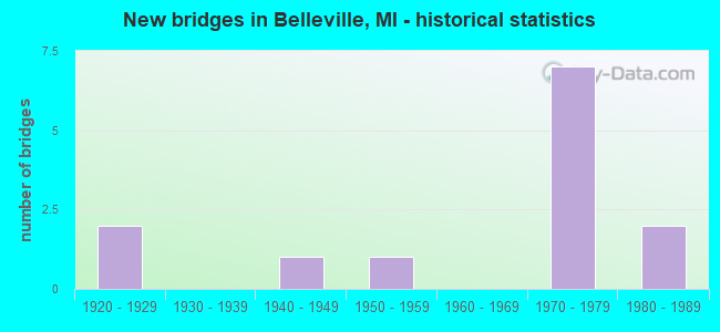
- New bridges - historical statistics
- 21920-1929
- 11940-1949
- 11950-1959
- 71970-1979
- 21980-1989

- Reconstructed bridges - Historical Statistics
- 11960-1969
- 01970-1979
- 01980-1989
- 11990-1999


- Bridge Condition - Deck
- 16.7%Good
- 66.7%Satisfactory
- 16.7%Fair

- Bridge Condition - Superstructure
- 33.3%Very good
- 16.7%Good
- 33.3%Satisfactory
- 16.7%Fair

- Bridge Condition - Substructure
- 33.3%Good
- 16.7%Satisfactory
- 33.3%Fair
- 16.7%Poor

- Bridge Condition - Channel
- 71.4%Very good
- 14.3%Good
- 14.3%Satisfactory

- Bridge Condition - Culverts
- 66.7%Good
- 33.3%Fair
Find on map >> Show street view
Structure Number: 10823, Location: 0.1 MI W OF WAYNE CO LINE (Lat: 42.218278, Lng: -83.545775), Route carried "on" structure: County highway 2057, Year Built: 1973, Status: Open, Structure Length: 9.23m (30.28ft), Average Daily Traffic: 23,491 (year 1996), Truck Traffic: 3%, Average Future Daily Traffic: 27,015 (year 2016), Design Load: HS 20, Features Intersected: I-94, Facility Carried by Structure: RAWSONVILLE RD
Minimum Vertical Clearance: 30.48m (100.00ft), Kilometerpoint: 14.771, Lanes on structure: 4, Lanes under structure: 7, Owner: State Highway Agency, Approaching Roadway Width: 20.7m (67.9ft), Skew: 1 degrees, Material/Design: Steel, Design/Construction: Stringer/Multi-beam, Number Of Spans In Main Unit: 4, Length of Maximum Span: 35.0m (114.8ft), Curb or Sidewalk Widths: Left: 0.2m (0.7ft), Right: 0.2m (0.7ft), Curb-To-Curb Width: 21.3m (69.9ft), Out-to-Out Width: 22.0m (72.2ft)
Condition: Deck: Satisfactory, Superstructure: Fair, Substructure: Fair, Operating Rating: 64.2 metric tons, Method Used To Determine Operating Rating: Load Factor (LF) rating reported by rating factor (RF) method using MS18 loading, Inventory Rating: 38.2 metric tons, Method Used To Determine Inventory Rating: Load Factor (LF) rating reported by rating factor (RF) method using MS18 loading, Structural Evaluation: Somewhat better than minimum adequacy, Deck Geometry: Superior to present desirable criteria, Underclear: Equal to present minimum criteria, Approach Roadway Alignment: Equal to present desirable criteria, Designated Inspection Frequency: Every 24 months, Other Special Inspection Frequency: Every 24 months, Inspection Date: August 2020, Other Special Inspection Date: August 2021, Deck Structure Type: Concrete Cast-file-Place, Wearing Surface/Protective System: Wearing Surface: Latex Concrete
Find on map >> Show street view
Structure Number: 11099, Location: 3.0 MI E OF WASHTENAW COL (Lat: 42.220067, Lng: -83.485161), Route carried "on" structure: County highway 2057, Year Built: 1974, Status: Open, Structure Length: 7.92m (25.98ft), Average Daily Traffic: 29,264 (year 1995), Truck Traffic: 12%, Average Future Daily Traffic: 50,300 (year 2017), Design Load: HS 20, Features Intersected: I-94, Facility Carried by Structure: BELLEVILLE RD
Minimum Vertical Clearance: 30.48m (100.00ft), Kilometerpoint: 1.461, Lanes on structure: 6, Lanes under structure: 8, Owner: State Highway Agency, Approaching Roadway Width: 26.4m (86.6ft), Material/Design: Steel continuous, Design/Construction: Stringer/Multi-beam, Number Of Spans In Main Unit: 2, Length of Maximum Span: 39.6m (129.9ft), Curb or Sidewalk Widths: Left: 0.0m, Right: 4.3m (14.1ft), Curb-To-Curb Width: 26.4m (86.6ft), Out-to-Out Width: 32.3m (106.0ft)
Condition: Deck: Satisfactory, Superstructure: Very good, Substructure: Good, Operating Rating: 75.2 metric tons, Method Used To Determine Operating Rating: Load Factor (LF) rating reported by rating factor (RF) method using MS18 loading, Inventory Rating: 45.0 metric tons, Method Used To Determine Inventory Rating: Load Factor (LF) rating reported by rating factor (RF) method using MS18 loading, Structural Evaluation: Better than present minimum criteria, Deck Geometry: Equal to present minimum criteria, Underclear: Somewhat better than minimum adequacy, Approach Roadway Alignment: Equal to present desirable criteria, Length Of Structure Improvement: 7.93m (26.02ft), Designated Inspection Frequency: Every 24 months, Inspection Date: May 2021, Bridge Improvement Cost: $541,000, Roadway Improvement Cost: $34,000, Total Project Cost: $405,000, Deck Structure Type: Concrete Cast-file-Place, Wearing Surface/Protective System: Wearing Surface: Monolithic Concrete
Find on map >> Show street view
Structure Number: 12033, Location: BELLEVILLE W/BELLEVILL RD (Lat: 42.210431, Lng: -83.494983), Route carried "on" structure: County highway , Year Built: 1947, Status: Open, Structure Length: 3.17m (10.40ft), Average Daily Traffic: 1,610 (year 1993), Truck Traffic: 1%, Average Future Daily Traffic: 1,852 (year 2015), Design Load: HS 20+Mod, Features Intersected: BELLEVILLE LK HURON RIVR, Facility Carried by Structure: DENTON ROAD
Minimum Vertical Clearance: 30.48m (100.00ft), Kilometerpoint: 2.575, Lanes on structure: 2, Owner: County Highway Agency, Approaching Roadway Width: 7.9m (25.9ft), Material/Design: Steel continuous, Design/Construction: Stringer/Multi-beam, Number Of Spans In Main Unit: 3, Length of Maximum Span: 11.8m (38.7ft), Curb or Sidewalk Widths: Left: 0.4m (1.3ft), Right: 1.2m (3.9ft), Curb-To-Curb Width: 6.7m (22.0ft), Out-to-Out Width: 8.9m (29.2ft)
Condition: Deck: Fair, Superstructure: Satisfactory, Substructure: Fair, Channel: Very good, Operating Rating: 92.7 metric tons, Method Used To Determine Operating Rating: Load Factor (LF) rating reported by rating factor (RF) method using MS18 loading, Inventory Rating: 36.0 metric tons, Method Used To Determine Inventory Rating: Load Factor (LF) rating reported by rating factor (RF) method using MS18 loading, Structural Evaluation: Somewhat better than minimum adequacy, Deck Geometry: High priority of corrective action, Waterway Adequacy: Superior to present desirable criteria, Approach Roadway Alignment: Equal to present desirable criteria, Designated Inspection Frequency: Every 24 months, Underwater Inspection Frequency: Every 60 months, Inspection Date: May 2021, Underwater Inspection Date: November 2018, Deck Structure Type: Concrete Cast-file-Place, Wearing Surface/Protective System: Wearing Surface: Monolithic Concrete
Find on map >> Show street view
Structure Number: 12034, Location: VAN BUREN E/RAWSONVILLE (Lat: 42.218292, Lng: -83.535553), Route carried "on" structure: County highway 2057, Year Built: 1975, Status: Open, Structure Length: 1.79m (5.87ft), Average Daily Traffic: 6,452 (year 1995), Truck Traffic: 5%, Average Future Daily Traffic: 7,153 (year 2015), Design Load: HS 20+Mod, Features Intersected: WILLOW RUN DRAIN, Facility Carried by Structure: SERVICE DR S I-94
Minimum Vertical Clearance: 30.48m (100.00ft), Kilometerpoint: 0.969, Lanes on structure: 2, Owner: County Highway Agency, Approaching Roadway Width: 12.2m (40.0ft), Skew: 4 degrees, Material/Design: Concrete, Design/Construction: Culvert, Number Of Spans In Main Unit: 3, Length of Maximum Span: 5.9m (19.4ft)
Condition: Channel: Good, Culverts: Good, Operating Rating: 54.5 metric tons, Method Used To Determine Operating Rating: Field evaluation and documented engineering judgment, Inventory Rating: 32.7 metric tons, Method Used To Determine Inventory Rating: Field evaluation and documented engineering judgment, Structural Evaluation: Better than present minimum criteria, Waterway Adequacy: Equal to present desirable criteria, Approach Roadway Alignment: Equal to present desirable criteria, Designated Inspection Frequency: Every 24 months, Inspection Date: June 2021
Find on map >> Show street view
Structure Number: 12035, Location: VAN BUREN E/RAWSONVILLE (Lat: 42.219278, Lng: -83.536728), Route carried "on" structure: County highway 2057, Year Built: 1975, Status: Open, Structure Length: 1.76m (5.77ft), Average Daily Traffic: 3,986 (year 2000), Truck Traffic: 7%, Average Future Daily Traffic: 5,974 (year 2015), Design Load: HS 20+Mod, Features Intersected: WILLOW RUN DRAIN, Facility Carried by Structure: SERVICE DR N I-94
Minimum Vertical Clearance: 30.48m (100.00ft), Kilometerpoint: 0.922, Lanes on structure: 2, Owner: County Highway Agency, Approaching Roadway Width: 12.2m (40.0ft), Skew: 4 degrees, Material/Design: Concrete, Design/Construction: Culvert, Number Of Spans In Main Unit: 3, Length of Maximum Span: 5.9m (19.4ft)
Condition: Channel: Satisfactory, Culverts: Fair, Operating Rating: 54.5 metric tons, Method Used To Determine Operating Rating: Field evaluation and documented engineering judgment, Inventory Rating: 32.7 metric tons, Method Used To Determine Inventory Rating: Field evaluation and documented engineering judgment, Structural Evaluation: Somewhat better than minimum adequacy, Waterway Adequacy: Equal to present desirable criteria, Approach Roadway Alignment: Equal to present desirable criteria, Designated Inspection Frequency: Every 24 months, Inspection Date: June 2021
Find on map >> Show street view
Structure Number: 12102, Location: VAN BUREN/WASH CO S/I-94 (Lat: 42.209158, Lng: -83.543431), Route carried "on" structure: County highway 2057, Year Built: 1982, Status: Open, Structure Length: 4.66m (15.29ft), Average Daily Traffic: 28,927 (year 1997), Truck Traffic: 8%, Average Future Daily Traffic: 22,899 (year 2015), Design Load: HS 20+Mod, Features Intersected: HURON RIVER, Facility Carried by Structure: RAWSONVILLE ROAD
Minimum Vertical Clearance: 30.48m (100.00ft), Kilometerpoint: 13.768, Lanes on structure: 2, Base Highway Network: Yes (Inventory Route: 143, Subroute: 5), Owner: County Highway Agency, Approaching Roadway Width: 14.6m (47.9ft), Material/Design: Prestressed concrete, Design/Construction: Box Beam or Girders - Multiple, Number Of Spans In Main Unit: 3, Length of Maximum Span: 15.5m (50.9ft), Curb or Sidewalk Widths: Left: 2.9m (9.5ft), Right: 2.9m (9.5ft), Curb-To-Curb Width: 15.2m (49.9ft), Out-to-Out Width: 21.9m (71.9ft)
Condition: Deck: Satisfactory, Superstructure: Good, Substructure: Satisfactory, Channel: Very good, Operating Rating: 54.8 metric tons, Method Used To Determine Operating Rating: Load Factor (LF) rating reported by rating factor (RF) method using MS18 loading, Inventory Rating: 32.7 metric tons, Method Used To Determine Inventory Rating: Load Factor (LF) rating reported by rating factor (RF) method using MS18 loading, Structural Evaluation: Equal to present minimum criteria, Deck Geometry: Superior to present desirable criteria, Waterway Adequacy: Equal to present desirable criteria, Approach Roadway Alignment: Equal to present desirable criteria, Designated Inspection Frequency: Every 24 months, Underwater Inspection Frequency: Every 60 months, Inspection Date: March 2021, Underwater Inspection Date: November 2021, Deck Structure Type: Concrete Precast Panels, Wearing Surface/Protective System: Wearing Surface: Integral Concrete, Deck Protection: Epoxy Coated Reinforcing
Find on map >> Show street view
Structure Number: 12108, Location: SUMPTER S/WILLIS (Lat: 42.157931, Lng: -83.482222), Route carried "on" structure: County highway 8211, Year Built: 1950, Year Reconstructed: 1972, Status: Open, Structure Length: 0.73m (2.40ft), Average Daily Traffic: 5,924 (year 1997), Truck Traffic: 5%, Average Future Daily Traffic: 5,604 (year 2015), Features Intersected: SWAN CREEK, Facility Carried by Structure: SUMPTER ROAD
Minimum Vertical Clearance: 30.48m (100.00ft), Kilometerpoint: 7.907, Lanes on structure: 2, Owner: County Highway Agency, Approaching Roadway Width: 10.9m (35.8ft), Skew: 4 degrees, Material/Design: Concrete, Design/Construction: Slab, Number Of Spans In Main Unit: 1, Length of Maximum Span: 6.4m (21.0ft), Curb or Sidewalk Widths: Left: 0.2m (0.7ft), Right: 0.2m (0.7ft), Curb-To-Curb Width: 10.9m (35.8ft), Out-to-Out Width: 11.4m (37.4ft)
Condition: Deck: Satisfactory, Superstructure: Satisfactory, Substructure: Poor, Channel: Very good, Operating Rating: 54.8 metric tons, Method Used To Determine Operating Rating: Load Factor (LF) rating reported by rating factor (RF) method using MS18 loading, Inventory Rating: 32.7 metric tons, Method Used To Determine Inventory Rating: Load Factor (LF) rating reported by rating factor (RF) method using MS18 loading, Structural Evaluation: Meets minimum limits, Deck Geometry: Meets minimum limits, Waterway Adequacy: Equal to present desirable criteria, Approach Roadway Alignment: Equal to present desirable criteria, Designated Inspection Frequency: Every 12 months, Inspection Date: May 2021, Deck Structure Type: Concrete Cast-file-Place, Wearing Surface/Protective System: Wearing Surface: Bituminous
Find on map >> Show street view
Structure Number: 12109, Location: BELLEVILLE S/I-94 (Lat: 42.211739, Lng: -83.492653), Route carried "on" structure: County highway 2057, Year Built: 1924, Year Reconstructed: 1995, Status: Open, Structure Length: 5.42m (17.78ft), Average Daily Traffic: 21,710 (year 1992), Average Future Daily Traffic: 24,966 (year 2015), Features Intersected: HURON RIVER, Facility Carried by Structure: BELLEVILLE ROAD
Minimum Vertical Clearance: 30.48m (100.00ft), Kilometerpoint: 0.148, Lanes on structure: 4, Base Highway Network: Yes (Inventory Route: 470, Subroute: 80), Owner: County Highway Agency, Approaching Roadway Width: 23.2m (76.1ft), Material/Design: Prestressed concrete, Design/Construction: Stringer/Multi-beam, Number Of Spans In Main Unit: 3, Length of Maximum Span: 36.5m (119.8ft), Curb or Sidewalk Widths: Left: 1.8m (5.9ft), Right: 4.2m (13.8ft), Curb-To-Curb Width: 15.9m (52.2ft), Out-to-Out Width: 22.7m (74.5ft)
Condition: Deck: Good, Superstructure: Very good, Substructure: Good, Channel: Very good, Operating Rating: 82.0 metric tons, Method Used To Determine Operating Rating: Load Factor (LF) rating reported by rating factor (RF) method using MS18 loading, Inventory Rating: 40.5 metric tons, Method Used To Determine Inventory Rating: Load Factor (LF) rating reported by rating factor (RF) method using MS18 loading, Structural Evaluation: Better than present minimum criteria, Deck Geometry: Meets minimum limits, Waterway Adequacy: Superior to present desirable criteria, Approach Roadway Alignment: Equal to present desirable criteria, Designated Inspection Frequency: Every 24 months, Underwater Inspection Frequency: Every 60 months, Inspection Date: March 2021, Underwater Inspection Date: August 2019, Deck Structure Type: Concrete Cast-file-Place, Wearing Surface/Protective System: Wearing Surface: Integral Concrete, Deck Protection: Epoxy Coated Reinforcing
Find on map >> Show street view
Structure Number: 1229, Location: SUMPTER 300 FT N/WILLIS (Lat: 42.160314, Lng: -83.500367), Route carried "on" structure: County highway , Year Built: 1986, Status: Open, Structure Length: 0.73m (2.40ft), Average Daily Traffic: 465 (year 1996), Truck Traffic: 1%, Average Future Daily Traffic: 605 (year 2015), Design Load: HS 25 or greater, Features Intersected: SWAN CREEK, Facility Carried by Structure: ELWELL ROAD
Minimum Vertical Clearance: 30.48m (100.00ft), Kilometerpoint: 8.206, Lanes on structure: 2, Owner: County Highway Agency, Approaching Roadway Width: 7.9m (25.9ft), Material/Design: Steel, Design/Construction: Culvert, Number Of Spans In Main Unit: 3, Length of Maximum Span: 1.8m (5.9ft), Out-to-Out Width: 19.8m (65.0ft)
Condition: Channel: Very good, Culverts: Good, Operating Rating: 58.0 metric tons, Method Used To Determine Operating Rating: Load Factor (LF) rating reported by rating factor (RF) method using MS18 loading, Inventory Rating: 34.7 metric tons, Method Used To Determine Inventory Rating: Load Factor (LF) rating reported by rating factor (RF) method using MS18 loading, Structural Evaluation: Better than present minimum criteria, Waterway Adequacy: Equal to present desirable criteria, Approach Roadway Alignment: Equal to present desirable criteria, Designated Inspection Frequency: Every 24 months, Inspection Date: August 2020
Find on map >> Show street view
Structure Number: 10823, Location: 0.1 MI W OF WAYNE CO LINE (Lat: 42.218278, Lng: -83.545775), Route carried "under" structure: Interstate 94, Year Built: 1973, Structure Length: 0. m, Average Daily Traffic: 83,910 (year 2007), Truck Traffic: 13%, Features Intersected: I-94, Facility Carried by Structure: RAWSONVILLE RD
Minimum Vertical Clearance: 5.21m (17.09ft), Kilometerpoint: 53.476, Lanes on structure: 4, Lanes under structure: 7, Material/Design: Steel, Design/Construction: Stringer/Multi-beam, Length of Maximum Span: 35.0m (114.8ft)
Find on map >> Show street view
Structure Number: 11098, Location: NORTH OF BELLEVILLE (Lat: 42.218975, Lng: -83.493750), Route carried "under" structure: Interstate 94, Year Built: 1977, Structure Length: 0. m, Average Daily Traffic: 89,072 (year 2007), Truck Traffic: 13%, Features Intersected: I-94, Facility Carried by Structure: QUIRK ROAD WALKOVE
Minimum Vertical Clearance: 6.12m (20.08ft), Kilometerpoint: 4.112, Lanes under structure: 6, Material/Design: Steel, Design/Construction: Stringer/Multi-beam, Length of Maximum Span: 33.5m (109.9ft)
Find on map >> Show street view
Structure Number: 11099, Location: 3.0 MI E OF WASHTENAW COL (Lat: 42.220067, Lng: -83.485161), Route carried "under" structure: Interstate 94, Year Built: 1974, Structure Length: 0. m, Average Daily Traffic: 104,464 (year 2007), Truck Traffic: 12%, Features Intersected: I-94, Facility Carried by Structure: BELLEVILLE RD
Minimum Vertical Clearance: 5.18m (16.99ft), Kilometerpoint: 4.823, Lanes on structure: 6, Lanes under structure: 8, Material/Design: Steel continuous, Design/Construction: Stringer/Multi-beam, Length of Maximum Span: 39.6m (129.9ft)
Find on map >> Show street view
Structure Number: 1211, Location: VAN BUREN N/VAN BORN (Lat: 42.261067, Lng: -83.486747), Route carried "under" structure: Bypass County highway 4464, Year Built: 1925, Structure Length: 0. m, Average Daily Traffic: 7,395 (year 1992), Truck Traffic: 5%, Features Intersected: BELLEVILLE ROAD, Facility Carried by Structure: MDOT RR CORRIDOR
Minimum Vertical Clearance: 4.42m (14.50ft), Kilometerpoint: 6.050, Lanes under structure: 4, Material/Design: Steel, Design/Construction: Girder and Floorbeam System, Length of Maximum Span: 18.2m (59.7ft)