Bridge Statistics for Belgium, Wisconsin (WI)
Condition, Traffic, Stress, Structural Evaluation, Project Costs
- National Bridge Inventory (NBI) Statistics
- 20Number of bridges
- 180ft / 55.5mTotal length
- 218,478Total average daily traffic
- 31,622Total average daily truck traffic
- National Bridge Inventory (NBI) Registered Bridges for Belgium
- No street view available for this location
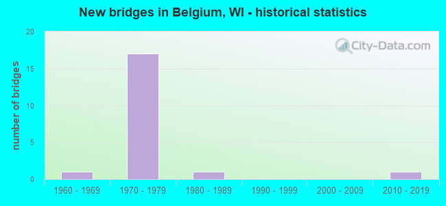
- New bridges - historical statistics
- 11960-1969
- 171970-1979
- 11980-1989
- 12010-2019


- Bridge Condition - Deck
- 30.0%Very good
- 30.0%Good
- 40.0%Satisfactory

- Bridge Condition - Superstructure
- 20.0%Very good
- 10.0%Good
- 60.0%Satisfactory
- 10.0%Fair

- Bridge Condition - Substructure
- 10.0%Very good
- 50.0%Good
- 40.0%Satisfactory

- Bridge Condition - Channel
- 33.3%Very good
- 50.0%Good
- 16.7%Satisfactory
Find on map >> Show street view
Structure Number: B450005, Location: 0.5M W JCT CTH KW (Lat: 43.484903, Lng: -87.870608), Route carried "on" structure: City street , Year Built: 1981, Status: Open, Structure Length: 1.87m (6.14ft), Average Daily Traffic: 58 (year 2019), Average Future Daily Traffic: 63 (year 2039), Design Load: H 20, Features Intersected: SAUK CREEK, Facility Carried by Structure: LRD CEDAR BEACH RD
Minimum Vertical Clearance: 30+ m (98+ ft), Kilometerpoint: 0.000, Lanes on structure: 2, Owner: Town or Township Highway Agency, Approaching Roadway Width: 7.3m (24.0ft), Skew: 2 degrees, Material/Design: Prestressed concrete, Design/Construction: Slab, Number Of Spans In Main Unit: 1, Length of Maximum Span: 17.6m (57.7ft), Curb-To-Curb Width: 7.3m (24.0ft), Out-to-Out Width: 7.3m (24.0ft)
Condition: Deck: Satisfactory, Superstructure: Very good, Substructure: Satisfactory, Channel: Very good, Operating Rating: 50.6 metric tons, Method Used To Determine Operating Rating: Load Factor (LF), Inventory Rating: 30.8 metric tons, Method Used To Determine Inventory Rating: Load Factor (LF), Structural Evaluation: Equal to present minimum criteria, Deck Geometry: Equal to present minimum criteria, Waterway Adequacy: Equal to present desirable criteria, Approach Roadway Alignment: Equal to present desirable criteria, Designated Inspection Frequency: Every 24 months, Inspection Date: September 2020, Deck Structure Type: Concrete Cast-file-Place, Wearing Surface/Protective System: Wearing Surface: Bituminous, Membrane: Other
Find on map >> Show street view
Structure Number: B450052, Location: 0.4 MI E JCT CTH LL (Lat: 43.455808, Lng: -87.832650), Route carried "on" structure: County highway , Year Built: 1974, Status: Open, Structure Length: 8.06m (26.44ft), Average Daily Traffic: 230 (year 2019), Average Future Daily Traffic: 230 (year 2039), Design Load: H 20, Features Intersected: IH 43-STH 32, Facility Carried by Structure: CTH P
Minimum Vertical Clearance: 30+ m (98+ ft), Kilometerpoint: 0.000, Lanes on structure: 2, Lanes under structure: 4, Owner: State Highway Agency, Approaching Roadway Width: 9.8m (32.2ft), Material/Design: Prestressed concrete continuous, Design/Construction: Stringer/Multi-beam, Number Of Spans In Main Unit: 2, Length of Maximum Span: 39.6m (129.9ft), Curb-To-Curb Width: 10.4m (34.1ft), Out-to-Out Width: 11.5m (37.7ft)
Condition: Deck: Good, Superstructure: Fair, Substructure: Good, Operating Rating: 44.1 metric tons, Method Used To Determine Operating Rating: Load Factor (LF), Inventory Rating: 27.5 metric tons, Method Used To Determine Inventory Rating: Load Factor (LF), Structural Evaluation: Somewhat better than minimum adequacy, Deck Geometry: Better than present minimum criteria, Underclear: Better than present minimum criteria, Approach Roadway Alignment: Equal to present desirable criteria, Designated Inspection Frequency: Every 24 months, Inspection Date: March 2020, Deck Structure Type: Concrete Cast-file-Place, Wearing Surface/Protective System: Wearing Surface: Low Slump Concrete
Find on map >> Show street view
Structure Number: B450053, Location: 0.5 MI E JCT CTH LL (Lat: 43.470375, Lng: -87.831017), Route carried "on" structure: City street , Year Built: 1974, Status: Open, Structure Length: 8.07m (26.48ft), Average Daily Traffic: 550 (year 2019), Average Future Daily Traffic: 550 (year 2039), Design Load: H 20, Features Intersected: IH 43-STH 32, Facility Carried by Structure: LRD SANDY BEACH RD
Minimum Vertical Clearance: 30+ m (98+ ft), Kilometerpoint: 0.000, Lanes on structure: 2, Lanes under structure: 4, Owner: State Highway Agency, Approaching Roadway Width: 7.3m (24.0ft), Material/Design: Prestressed concrete continuous, Design/Construction: Stringer/Multi-beam, Number Of Spans In Main Unit: 2, Length of Maximum Span: 40.7m (133.5ft), Curb-To-Curb Width: 10.4m (34.1ft), Out-to-Out Width: 10.8m (35.4ft)
Condition: Deck: Very good, Superstructure: Satisfactory, Substructure: Good, Operating Rating: 55.5 metric tons, Method Used To Determine Operating Rating: Load Factor (LF), Inventory Rating: 34.0 metric tons, Method Used To Determine Inventory Rating: Load Factor (LF), Structural Evaluation: Equal to present minimum criteria, Deck Geometry: Equal to present minimum criteria, Underclear: Equal to present minimum criteria, Approach Roadway Alignment: Equal to present desirable criteria, Designated Inspection Frequency: Every 24 months, Inspection Date: June 2020, Deck Structure Type: Concrete Cast-file-Place, Wearing Surface/Protective System: Wearing Surface: Low Slump Concrete
Find on map >> Show street view
Structure Number: B450054, Location: 0.5M E JCT CTH LL (Lat: 43.484936, Lng: -87.830994), Route carried "on" structure: City street , Year Built: 1974, Status: Open, Structure Length: 7.95m (26.08ft), Average Daily Traffic: 230 (year 2019), Average Future Daily Traffic: 230 (year 2039), Design Load: H 20, Features Intersected: IH 43-STH 32, Facility Carried by Structure: LRD CEDAR BEACH RD
Minimum Vertical Clearance: 30+ m (98+ ft), Kilometerpoint: 0.000, Lanes on structure: 2, Lanes under structure: 4, Owner: State Highway Agency, Approaching Roadway Width: 8.5m (27.9ft), Material/Design: Prestressed concrete continuous, Design/Construction: Stringer/Multi-beam, Number Of Spans In Main Unit: 2, Length of Maximum Span: 39.6m (129.9ft), Curb-To-Curb Width: 10.4m (34.1ft), Out-to-Out Width: 10.8m (35.4ft)
Condition: Deck: Good, Superstructure: Satisfactory, Substructure: Satisfactory, Operating Rating: 52.3 metric tons, Method Used To Determine Operating Rating: Load Factor (LF), Inventory Rating: 34.0 metric tons, Method Used To Determine Inventory Rating: Load Factor (LF), Structural Evaluation: Equal to present minimum criteria, Deck Geometry: Better than present minimum criteria, Underclear: Somewhat better than minimum adequacy, Approach Roadway Alignment: Equal to present desirable criteria, Designated Inspection Frequency: Every 24 months, Inspection Date: June 2020, Deck Structure Type: Concrete Cast-file-Place, Wearing Surface/Protective System: Wearing Surface: Low Slump Concrete
Find on map >> Show street view
Structure Number: B450055, Location: 0.1M E JCT CTH LL (Lat: 43.499436, Lng: -87.831092), Route carried "on" structure: County highway , Year Built: 1974, Status: Open, Structure Length: 7.96m (26.12ft), Average Daily Traffic: 5,400 (year 2019), Average Future Daily Traffic: 5,400 (year 2039), Design Load: HS 20, Features Intersected: IH 43-STH 32, Facility Carried by Structure: CTH D
Minimum Vertical Clearance: 30+ m (98+ ft), Kilometerpoint: 0.000, Lanes on structure: 2, Lanes under structure: 4, Owner: State Highway Agency, Approaching Roadway Width: 9.1m (29.9ft), Skew: 20 degrees, Material/Design: Steel continuous, Design/Construction: Stringer/Multi-beam, Number Of Spans In Main Unit: 2, Length of Maximum Span: 40.2m (131.9ft), Curb-To-Curb Width: 15.8m (51.8ft), Out-to-Out Width: 21.6m (70.9ft)
Condition: Deck: Satisfactory, Superstructure: Satisfactory, Substructure: Good, Operating Rating: 39.2 metric tons, Method Used To Determine Operating Rating: Load Factor (LF), Inventory Rating: 22.7 metric tons, Method Used To Determine Inventory Rating: Load Factor (LF), Structural Evaluation: Somewhat better than minimum adequacy, Deck Geometry: Superior to present desirable criteria, Underclear: Better than present minimum criteria, Approach Roadway Alignment: Equal to present desirable criteria, Designated Inspection Frequency: Every 24 months, Inspection Date: March 2020, Deck Structure Type: Concrete Cast-file-Place, Wearing Surface/Protective System: Wearing Surface: Low Slump Concrete
Find on map >> Show street view
Structure Number: B450056, Location: 0.2M E JCT CTH LL (Lat: 43.514028, Lng: -87.824914), Route carried "on" structure: City street , Year Built: 1974, Status: Open, Structure Length: 8.50m (27.89ft), Average Daily Traffic: 95 (year 2019), Average Future Daily Traffic: 95 (year 2039), Design Load: H 20, Features Intersected: IH 43-STH 32, Facility Carried by Structure: LRD SILVER BEACH R
Minimum Vertical Clearance: 30+ m (98+ ft), Kilometerpoint: 0.000, Lanes on structure: 2, Lanes under structure: 4, Owner: State Highway Agency, Approaching Roadway Width: 9.1m (29.9ft), Skew: 1 degrees, Material/Design: Steel continuous, Design/Construction: Stringer/Multi-beam, Number Of Spans In Main Unit: 2, Length of Maximum Span: 42.7m (140.1ft), Curb-To-Curb Width: 10.4m (34.1ft), Out-to-Out Width: 11.5m (37.7ft)
Condition: Deck: Good, Superstructure: Satisfactory, Substructure: Good, Operating Rating: 49.0 metric tons, Method Used To Determine Operating Rating: Load Factor (LF), Inventory Rating: 29.2 metric tons, Method Used To Determine Inventory Rating: Load Factor (LF), Structural Evaluation: Equal to present minimum criteria, Deck Geometry: Superior to present desirable criteria, Underclear: Equal to present minimum criteria, Approach Roadway Alignment: Equal to present desirable criteria, Designated Inspection Frequency: Every 24 months, Inspection Date: May 2020, Deck Structure Type: Concrete Cast-file-Place, Wearing Surface/Protective System: Wearing Surface: Low Slump Concrete
Find on map >> Show street view
Structure Number: B450057, Location: 3.2 MI S JCT STH 32 (Lat: 43.528808, Lng: -87.821722), Route carried "on" structure: Interstate 43, Year Built: 1974, Status: Open, Structure Length: 3.70m (12.14ft), Average Daily Traffic: 12,400 (year 2019), Truck Traffic: 15%, Average Future Daily Traffic: 16,707 (year 2039), Design Load: HS 20, Features Intersected: LRD JAY RD
Minimum Vertical Clearance: 30+ m (98+ ft), Kilometerpoint: 0.000, Lanes on structure: 2, Lanes under structure: 2, Base Highway Network: Yes, Owner: State Highway Agency, Approaching Roadway Width: 12.2m (40.0ft), Skew: 1 degrees, Material/Design: Prestressed concrete continuous, Design/Construction: Stringer/Multi-beam, Number Of Spans In Main Unit: 3, Length of Maximum Span: 16.6m (54.5ft), Curb-To-Curb Width: 12.2m (40.0ft), Out-to-Out Width: 13.0m (42.7ft)
Condition: Deck: Satisfactory, Superstructure: Satisfactory, Substructure: Satisfactory, Operating Rating: 42.5 metric tons, Method Used To Determine Operating Rating: Load Factor (LF), Inventory Rating: 24.3 metric tons, Method Used To Determine Inventory Rating: Load Factor (LF), Structural Evaluation: Equal to present minimum criteria, Deck Geometry: Better than present minimum criteria, Underclear: Better than present minimum criteria, Approach Roadway Alignment: Equal to present desirable criteria, Designated Inspection Frequency: Every 24 months, Inspection Date: June 2020, Deck Structure Type: Concrete Cast-file-Place, Wearing Surface/Protective System: Wearing Surface: Low Slump Concrete
Find on map >> Show street view
Structure Number: B450058, Location: 2.1 MI N JCT CTH D (Lat: 43.528436, Lng: -87.821219), Route carried "on" structure: Interstate 43, Year Built: 1974, Status: Open, Structure Length: 3.70m (12.14ft), Average Daily Traffic: 12,400 (year 2019), Truck Traffic: 15%, Average Future Daily Traffic: 16,912 (year 2039), Design Load: HS 20, Features Intersected: LRD JAY RD
Minimum Vertical Clearance: 30+ m (98+ ft), Kilometerpoint: 0.000, Lanes on structure: 2, Lanes under structure: 2, Base Highway Network: Yes, Owner: State Highway Agency, Approaching Roadway Width: 12.2m (40.0ft), Skew: 1 degrees, Material/Design: Prestressed concrete continuous, Design/Construction: Stringer/Multi-beam, Number Of Spans In Main Unit: 3, Length of Maximum Span: 16.6m (54.5ft), Curb-To-Curb Width: 12.2m (40.0ft), Out-to-Out Width: 13.0m (42.7ft)
Condition: Deck: Satisfactory, Superstructure: Satisfactory, Substructure: Satisfactory, Operating Rating: 58.8 metric tons, Method Used To Determine Operating Rating: Load Factor (LF), Inventory Rating: 29.2 metric tons, Method Used To Determine Inventory Rating: Load Factor (LF), Structural Evaluation: Equal to present minimum criteria, Deck Geometry: Better than present minimum criteria, Underclear: Better than present minimum criteria, Approach Roadway Alignment: Equal to present desirable criteria, Designated Inspection Frequency: Every 24 months, Inspection Date: June 2020, Deck Structure Type: Concrete Cast-file-Place, Wearing Surface/Protective System: Wearing Surface: Low Slump Concrete
Find on map >> Show street view
Structure Number: B450064, Location: 3.7M N JCT STH 32 TO S (Lat: 43.452125, Lng: -87.832575), Route carried "on" structure: Interstate 43, Year Built: 1974, Status: Open, Structure Length: 0.96m (3.15ft), Average Daily Traffic: 27,100 (year 2018), Truck Traffic: 15%, Average Future Daily Traffic: 32,360 (year 2039), Design Load: HS 20, Features Intersected: SUCKER CREEK
Minimum Vertical Clearance: 30+ m (98+ ft), Kilometerpoint: 0.000, Lanes on structure: 4, Base Highway Network: Yes, Owner: State Highway Agency, Approaching Roadway Width: 48.2m (158.1ft), Skew: 4 degrees, Material/Design: Concrete continuous, Design/Construction: Culvert, Number Of Spans In Main Unit: 2, Length of Maximum Span: 3.0m (9.8ft)
Condition: Channel: Good, Culverts: Satisfactory, Operating Rating: 53.9 metric tons, Method Used To Determine Operating Rating: Field evaluation and documented engineering judgment, Inventory Rating: 32.4 metric tons, Method Used To Determine Inventory Rating: Field evaluation and documented engineering judgment, Structural Evaluation: Equal to present minimum criteria, Waterway Adequacy: Equal to present desirable criteria, Approach Roadway Alignment: Equal to present desirable criteria, Designated Inspection Frequency: Every 24 months, Inspection Date: May 2020, Deck Structure Type: Concrete Cast-file-Place, Wearing Surface/Protective System: Wearing Surface: Monolithic Concrete
Find on map >> Show street view
Structure Number: B450065, Location: 0.3M E JCT CTH LL (Lat: 43.455814, Lng: -87.832653), Route carried "on" structure: County highway , Year Built: 1974, Status: Open, Structure Length: 0.68m (2.23ft), Average Daily Traffic: 210 (year 2019), Average Future Daily Traffic: 210 (year 2040), Design Load: H 20, Features Intersected: SUCKER CREEK, Facility Carried by Structure: CTH P
Minimum Vertical Clearance: 30+ m (98+ ft), Kilometerpoint: 0.000, Lanes on structure: 2, Owner: State Highway Agency, Approaching Roadway Width: 10.4m (34.1ft), Material/Design: Concrete continuous, Design/Construction: Culvert, Number Of Spans In Main Unit: 2, Length of Maximum Span: 3.0m (9.8ft)
Condition: Channel: Good, Culverts: Satisfactory, Operating Rating: 53.9 metric tons, Method Used To Determine Operating Rating: Field evaluation and documented engineering judgment, Inventory Rating: 24.3 metric tons, Method Used To Determine Inventory Rating: Field evaluation and documented engineering judgment, Structural Evaluation: Equal to present minimum criteria, Waterway Adequacy: Equal to present desirable criteria, Approach Roadway Alignment: Equal to present desirable criteria, Designated Inspection Frequency: Every 24 months, Inspection Date: October 2021, Deck Structure Type: Concrete Cast-file-Place, Wearing Surface/Protective System: Wearing Surface: Bituminous
Find on map >> Show street view
Structure Number: B450066, Location: 4.6M N JCT STH 32 TO S (Lat: 43.464625, Lng: -87.831189), Route carried "on" structure: Interstate 43, Year Built: 1974, Status: Open, Structure Length: 0.76m (2.49ft), Average Daily Traffic: 24,800 (year 2019), Truck Traffic: 15%, Average Future Daily Traffic: 32,360 (year 2039), Design Load: HS 20, Features Intersected: SUCKER CREEK
Minimum Vertical Clearance: 30+ m (98+ ft), Kilometerpoint: 0.000, Lanes on structure: 4, Base Highway Network: Yes, Owner: State Highway Agency, Approaching Roadway Width: 48.2m (158.1ft), Skew: 3 degrees, Material/Design: Concrete continuous, Design/Construction: Culvert, Number Of Spans In Main Unit: 2, Length of Maximum Span: 2.7m (8.9ft)
Condition: Channel: Satisfactory, Culverts: Satisfactory, Operating Rating: 53.9 metric tons, Method Used To Determine Operating Rating: Field evaluation and documented engineering judgment, Inventory Rating: 32.4 metric tons, Method Used To Determine Inventory Rating: Field evaluation and documented engineering judgment, Structural Evaluation: Equal to present minimum criteria, Waterway Adequacy: Equal to present desirable criteria, Approach Roadway Alignment: Equal to present desirable criteria, Designated Inspection Frequency: Every 24 months, Inspection Date: May 2020, Deck Structure Type: Concrete Cast-file-Place, Wearing Surface/Protective System: Wearing Surface: Monolithic Concrete
Find on map >> Show street view
Structure Number: B4501, Location: 0.3M W JCT CTH KW (Lat: 43.470347, Lng: -87.869606), Route carried "on" structure: County highway , Year Built: 2013, Status: Open, Structure Length: 2.27m (7.45ft), Average Daily Traffic: 820 (year 2019), Truck Traffic: 4%, Average Future Daily Traffic: 588 (year 2039), Design Load: HL 93, Features Intersected: SAUK CREEK, Facility Carried by Structure: CTH A
Minimum Vertical Clearance: 30+ m (98+ ft), Kilometerpoint: 0.000, Lanes on structure: 2, Owner: County Highway Agency, Approaching Roadway Width: 11.0m (36.1ft), Material/Design: Prestressed concrete, Design/Construction: Stringer/Multi-beam, Number Of Spans In Main Unit: 1, Length of Maximum Span: 21.9m (71.9ft), Curb-To-Curb Width: 11.0m (36.1ft), Out-to-Out Width: 11.7m (38.4ft)
Condition: Deck: Very good, Superstructure: Very good, Substructure: Very good, Channel: Very good, Operating Rating: 57.7 metric tons, Method Used To Determine Operating Rating: Load and Resistance Factor Rating (LRFR) rating reported by rating factor(RF) method using HL-93 loadings, Inventory Rating: 43.7 metric tons, Method Used To Determine Inventory Rating: Load and Resistance Factor Rating (LRFR) rating reported by rating factor(RF) method using HL-93 loadings, Structural Evaluation: Equal to present desirable criteria, Deck Geometry: Better than present minimum criteria, Waterway Adequacy: Equal to present desirable criteria, Approach Roadway Alignment: Equal to present desirable criteria, Designated Inspection Frequency: Every 48 months, Inspection Date: September 2020, Deck Structure Type: Concrete Cast-file-Place, Wearing Surface/Protective System: Wearing Surface: Monolithic Concrete, Deck Protection: Epoxy Coated Reinforcing
Find on map >> Show street view
Structure Number: P450024, Location: 0.3M S JCT CTH D (Lat: 43.496269, Lng: -87.880528), Route carried "on" structure: City street , Year Built: 1962, Status: Open, Structure Length: 1.01m (3.31ft), Average Daily Traffic: 105 (year 2019), Average Future Daily Traffic: 115 (year 2039), Design Load: H 15, Features Intersected: SAUK CREEK, Facility Carried by Structure: LRD SIX MILE RD
Minimum Vertical Clearance: 30+ m (98+ ft), Kilometerpoint: 0.000, Lanes on structure: 2, Owner: Town or Township Highway Agency, Approaching Roadway Width: 7.3m (24.0ft), Skew: 1 degrees, Material/Design: Prestressed concrete, Design/Construction: Stringer/Multi-beam, Number Of Spans In Main Unit: 1, Length of Maximum Span: 9.1m (29.9ft), Curb-To-Curb Width: 7.4m (24.3ft), Out-to-Out Width: 8.3m (27.2ft)
Condition: Deck: Very good, Superstructure: Good, Substructure: Good, Channel: Good, Operating Rating: 31.0 metric tons, Method Used To Determine Operating Rating: Field evaluation and documented engineering judgment, Inventory Rating: 17.8 metric tons, Method Used To Determine Inventory Rating: Field evaluation and documented engineering judgment, Structural Evaluation: Somewhat better than minimum adequacy, Deck Geometry: Somewhat better than minimum adequacy, Waterway Adequacy: Equal to present minimum criteria, Approach Roadway Alignment: Equal to present desirable criteria, Designated Inspection Frequency: Every 24 months, Inspection Date: September 2020, Deck Structure Type: Concrete Cast-file-Place, Wearing Surface/Protective System: Wearing Surface: Bituminous
Find on map >> Show street view
Structure Number: B450052, Location: 4.0M N JCT STH 32 TO S (Lat: 43.455808, Lng: -87.832650), Route carried "under" structure: Interstate 43, Year Built: 1974, Structure Length: 0. m, Average Daily Traffic: 27,100 (year 2018), Truck Traffic: 15%, Features Intersected: IH 43-STH 32, Facility Carried by Structure: CTH P
Minimum Vertical Clearance: 5.18m (16.99ft), Kilometerpoint: 0.000, Lanes on structure: 2, Lanes under structure: 4, Material/Design: Prestressed concrete continuous, Design/Construction: Stringer/Multi-beam, Length of Maximum Span: 39.6m (129.9ft)
Find on map >> Show street view
Structure Number: B450053, Location: 5.0M N JCT STH 32 TO S (Lat: 43.470375, Lng: -87.831017), Route carried "under" structure: Interstate 43, Year Built: 1974, Structure Length: 0. m, Average Daily Traffic: 28,600 (year 2019), Truck Traffic: 15%, Features Intersected: IH 43-STH 32, Facility Carried by Structure: LRD SANDY BEACH RD
Minimum Vertical Clearance: 5.06m (16.60ft), Kilometerpoint: 0.000, Lanes on structure: 2, Lanes under structure: 4, Material/Design: Prestressed concrete continuous, Design/Construction: Stringer/Multi-beam, Length of Maximum Span: 40.7m (133.5ft)
Find on map >> Show street view
Structure Number: B450054, Location: 6.0M N JCT STH 32 TO S (Lat: 43.484936, Lng: -87.830994), Route carried "under" structure: Interstate 43, Year Built: 1974, Structure Length: 0. m, Average Daily Traffic: 28,600 (year 2019), Truck Traffic: 15%, Features Intersected: IH 43-STH 32, Facility Carried by Structure: LRD CEDAR BEACH RD
Minimum Vertical Clearance: 4.96m (16.27ft), Kilometerpoint: 0.000, Lanes on structure: 2, Lanes under structure: 4, Material/Design: Prestressed concrete continuous, Design/Construction: Stringer/Multi-beam, Length of Maximum Span: 39.6m (129.9ft)
Find on map >> Show street view
Structure Number: B450055, Location: 7.0M N JCT STH 84 TO W (Lat: 43.499436, Lng: -87.831092), Route carried "under" structure: Interstate 43, Year Built: 1974, Structure Length: 0. m, Average Daily Traffic: 24,800 (year 2019), Truck Traffic: 15%, Features Intersected: IH 43-STH 32, Facility Carried by Structure: CTH D
Minimum Vertical Clearance: 5.15m (16.90ft), Kilometerpoint: 0.000, Lanes on structure: 2, Lanes under structure: 4, Material/Design: Steel continuous, Design/Construction: Stringer/Multi-beam, Length of Maximum Span: 40.2m (131.9ft)
Find on map >> Show street view
Structure Number: B450056, Location: 1.3M N JCT CTH D TO E (Lat: 43.514028, Lng: -87.824914), Route carried "under" structure: Interstate 43, Year Built: 1974, Structure Length: 0. m, Average Daily Traffic: 24,800 (year 2019), Truck Traffic: 15%, Features Intersected: IH 43-STH 32, Facility Carried by Structure: LRD SILVER BEACH R
Minimum Vertical Clearance: 5.09m (16.70ft), Kilometerpoint: 0.000, Lanes on structure: 2, Lanes under structure: 4, Material/Design: Steel continuous, Design/Construction: Stringer/Multi-beam, Length of Maximum Span: 42.7m (140.1ft)
Find on map >> Show street view
Structure Number: B450057, Location: 0.1M E JCT CTH LL (Lat: 43.528808, Lng: -87.821722), Route carried "under" structure: City street , Year Built: 1974, Structure Length: 0. m, Average Daily Traffic: 90 (year 2019), Features Intersected: LRD JAY RD, Facility Carried by Structure: IH 43 SB-STH 32 SB
Minimum Vertical Clearance: 4.88m (16.01ft), Kilometerpoint: 0.000, Lanes on structure: 2, Lanes under structure: 2, Material/Design: Prestressed concrete continuous, Design/Construction: Stringer/Multi-beam, Length of Maximum Span: 16.6m (54.5ft)
Find on map >> Show street view
Structure Number: B450058, Location: 0.1M E JCT CTH LL (Lat: 43.528436, Lng: -87.821219), Route carried "under" structure: City street , Year Built: 1974, Structure Length: 0. m, Average Daily Traffic: 90 (year 2019), Features Intersected: LRD JAY RD, Facility Carried by Structure: IH 43 NB-STH 32 NB
Minimum Vertical Clearance: 4.82m (15.81ft), Kilometerpoint: 0.000, Lanes on structure: 2, Lanes under structure: 2, Material/Design: Prestressed concrete continuous, Design/Construction: Stringer/Multi-beam, Length of Maximum Span: 16.6m (54.5ft)