Bridge Statistics for Belding, Michigan (MI)
Condition, Traffic, Stress, Structural Evaluation, Project Costs
- National Bridge Inventory (NBI) Statistics
- 11Number of bridges
- 121ft / 37.2mTotal length
- 28,079Total average daily traffic
- 1,193Total average daily truck traffic
- 36,798Total future (year 2018) average daily traffic
- National Bridge Inventory (NBI) Registered Bridges for Belding
- No street view available for this location
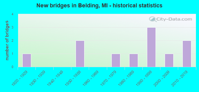
- New bridges - historical statistics
- 11920-1929
- 21950-1959
- 11970-1979
- 11980-1989
- 31990-1999
- 12000-2009
- 22010-2019


- Bridge Condition - Deck
- 20.0%Very good
- 60.0%Good
- 20.0%Satisfactory

- Bridge Condition - Superstructure
- 20.0%Very good
- 40.0%Good
- 30.0%Satisfactory
- 10.0%Fair

- Bridge Condition - Substructure
- 30.0%Very good
- 30.0%Good
- 30.0%Satisfactory
- 10.0%Fair

- Bridge Condition - Channel
- 54.5%Very good
- 9.1%Good
- 36.4%Satisfactory
Find on map >> Show street view
Structure Number: 4014, Location: IN BELDING (Lat: 43.088869, Lng: -85.234939), Route carried "on" structure: State highway 44, Year Built: 1950, Year Reconstructed: 1998, Status: Open, Structure Length: 12.62m (41.40ft), Average Daily Traffic: 9,043 (year 2007), Truck Traffic: 4%, Average Future Daily Traffic: 11,854 (year 2018), Design Load: HS 25 or greater, Features Intersected: MID MICH RR & FLAT RIVER
Minimum Vertical Clearance: 30.48m (100.00ft), Kilometerpoint: 6.285, Lanes on structure: 2, Owner: State Highway Agency, Approaching Roadway Width: 12.8m (42.0ft), Material/Design: Steel continuous, Design/Construction: Girder and Floorbeam System, Number Of Spans In Main Unit: 4, Length of Maximum Span: 39.6m (129.9ft), Curb or Sidewalk Widths: Left: 1.7m (5.6ft), Right: 1.7m (5.6ft), Curb-To-Curb Width: 8.5m (27.9ft), Out-to-Out Width: 12.9m (42.3ft)
Condition: Deck: Good, Superstructure: Satisfactory, Substructure: Fair, Channel: Very good, Operating Rating: 66.1 metric tons, Method Used To Determine Operating Rating: Load Factor (LF) rating reported by rating factor (RF) method using MS18 loading, Inventory Rating: 39.5 metric tons, Method Used To Determine Inventory Rating: Load Factor (LF) rating reported by rating factor (RF) method using MS18 loading, Structural Evaluation: Somewhat better than minimum adequacy, Deck Geometry: Meets minimum limits, Underclear: Equal to present minimum criteria, Waterway Adequacy: Somewhat better than minimum adequacy, Approach Roadway Alignment: Equal to present desirable criteria, Designated Inspection Frequency: Every 24 months, Critical Feature Inspection Frequency: Every 15 months, Inspection Date: December 2020, Critical Feature Inspection Date: July 2021, Deck Structure Type: Concrete Cast-file-Place, Wearing Surface/Protective System: Wearing Surface: Monolithic Concrete, Deck Protection: Epoxy Coated Reinforcing
Find on map >> Show street view
Structure Number: 4089, Location: 0.5 MILE NORTH OF SMYRNA (Lat: 43.066414, Lng: -85.269122), Route carried "on" structure: ServiceCounty highway , Year Built: 1973, Status: Posted for load, Structure Length: 0.79m (2.59ft), Average Daily Traffic: 99 (year 2008), Truck Traffic: 2%, Average Future Daily Traffic: 115 (year 2028), Design Load: HS 20+Mod, Features Intersected: SEELEY CREEK, Facility Carried by Structure: GOLD LAKE ROAD
Minimum Vertical Clearance: 30.48m (100.00ft), Kilometerpoint: 1.996, Lanes on structure: 2, Owner: County Highway Agency, Approaching Roadway Width: 7.6m (24.9ft), Material/Design: Wood or Timber, Design/Construction: Slab, Number Of Spans In Main Unit: 1, Length of Maximum Span: 7.9m (25.9ft), Curb-To-Curb Width: 9.1m (29.9ft), Out-to-Out Width: 9.6m (31.5ft)
Condition: Deck: Satisfactory, Superstructure: Satisfactory, Substructure: Satisfactory, Channel: Satisfactory, Operating Rating: 31.8 metric tons, Method Used To Determine Operating Rating: Allowable Stress (AS) rating reported by rating factor (RF) method using MS18 loading, Inventory Rating: 20.4 metric tons, Method Used To Determine Inventory Rating: Allowable Stress (AS) rating reported by rating factor (RF) method using MS18 loading, Structural Evaluation: Somewhat better than minimum adequacy, Deck Geometry: Better than present minimum criteria, Waterway Adequacy: Better than present minimum criteria, Approach Roadway Alignment: Better than present minimum criteria, Bridge Posting: Required (Relationship of Operating Rating to Maximum Legal Load: 30.0 - 39.9% below), Designated Inspection Frequency: Every 24 months, Inspection Date: October 2020, Deck Structure Type: Wood or Timber, Wearing Surface/Protective System: Wearing Surface: Gravel
Find on map >> Show street view
Structure Number: 409, Location: 0.5 MILES EAST OF SYMRNA (Lat: 43.059992, Lng: -85.255008), Route carried "on" structure: ServiceCounty highway , Year Built: 1999, Status: Open, Structure Length: 2.55m (8.37ft), Average Daily Traffic: 102 (year 2008), Truck Traffic: 5%, Average Future Daily Traffic: 119 (year 2028), Design Load: HS 20, Features Intersected: MILLE RACE, Facility Carried by Structure: DUMON ROAD
Minimum Vertical Clearance: 30.48m (100.00ft), Kilometerpoint: 0.140, Lanes on structure: 2, Owner: County Highway Agency, Approaching Roadway Width: 8.8m (28.9ft), Material/Design: Prestressed concrete, Design/Construction: Box Beam or Girders - Multiple, Number Of Spans In Main Unit: 1, Length of Maximum Span: 25.5m (83.7ft), Curb-To-Curb Width: 8.8m (28.9ft), Out-to-Out Width: 9.5m (31.2ft)
Condition: Deck: Very good, Superstructure: Good, Substructure: Very good, Channel: Satisfactory, Operating Rating: 96.2 metric tons, Method Used To Determine Operating Rating: Load Factor (LF) rating reported by rating factor (RF) method using MS18 loading, Inventory Rating: 57.7 metric tons, Method Used To Determine Inventory Rating: Load Factor (LF) rating reported by rating factor (RF) method using MS18 loading, Structural Evaluation: Better than present minimum criteria, Deck Geometry: Equal to present minimum criteria, Waterway Adequacy: Equal to present desirable criteria, Approach Roadway Alignment: Equal to present desirable criteria, Designated Inspection Frequency: Every 24 months, Inspection Date: October 2020, Deck Structure Type: Concrete Cast-file-Place, Wearing Surface/Protective System: Wearing Surface: Monolithic Concrete, Deck Protection: Epoxy Coated Reinforcing
Find on map >> Show street view
Structure Number: 4096, Location: IN BELDING (Lat: 43.097850, Lng: -85.234642), Route carried "on" structure: City street 2070, Year Built: 2014, Status: Open, Structure Length: 4.27m (14.01ft), Average Daily Traffic: 748 (year 2014), Truck Traffic: 2%, Average Future Daily Traffic: 913 (year 2034), Design Load: Greater than HL93, Features Intersected: FLAT RIVER, Facility Carried by Structure: MAIN ST
Minimum Vertical Clearance: 30.48m (100.00ft), Kilometerpoint: 1.296, Lanes on structure: 2, Owner: City or Municipal Highway Agency, Approaching Roadway Width: 8.6m (28.2ft), Material/Design: Prestressed concrete, Design/Construction: Box Beam or Girders - Single/Spread, Number Of Spans In Main Unit: 2, Length of Maximum Span: 20.6m (67.6ft), Curb or Sidewalk Widths: Left: 1.8m (5.9ft), Right: 3.0m (9.8ft), Curb-To-Curb Width: 8.2m (26.9ft), Out-to-Out Width: 14.1m (46.3ft)
Condition: Deck: Good, Superstructure: Very good, Substructure: Very good, Channel: Very good, Operating Rating: 48.9 metric tons, Method Used To Determine Operating Rating: Load and Resistance Factor Rating (LRFR) rating reported by rating factor(RF) method using HL-93 loadings, Inventory Rating: 38.6 metric tons, Method Used To Determine Inventory Rating: Load and Resistance Factor Rating (LRFR) rating reported by rating factor(RF) method using HL-93 loadings, Structural Evaluation: Equal to present desirable criteria, Deck Geometry: Somewhat better than minimum adequacy, Waterway Adequacy: Better than present minimum criteria, Approach Roadway Alignment: Equal to present minimum criteria, Designated Inspection Frequency: Every 24 months, Inspection Date: October 2020, Deck Structure Type: Concrete Cast-file-Place, Wearing Surface/Protective System: Wearing Surface: Monolithic Concrete, Deck Protection: Epoxy Coated Reinforcing
Find on map >> Show street view
Structure Number: 4097, Location: IN BELDING (Lat: 43.100303, Lng: -85.228139), Route carried "on" structure: City street 2070, Year Built: 2005, Status: Open, Structure Length: 4.57m (14.99ft), Average Daily Traffic: 4,777 (year 2005), Truck Traffic: 3%, Average Future Daily Traffic: 5,123 (year 2023), Design Load: HS 20, Features Intersected: FLAT RIVER, Facility Carried by Structure: BRIDGE ST
Minimum Vertical Clearance: 30.48m (100.00ft), Kilometerpoint: 6.941, Lanes on structure: 2, Owner: City or Municipal Highway Agency, Approaching Roadway Width: 9.1m (29.9ft), Material/Design: Prestressed concrete, Design/Construction: Box Beam or Girders - Single/Spread, Number Of Spans In Main Unit: 2, Length of Maximum Span: 21.9m (71.9ft), Curb or Sidewalk Widths: Left: 1.9m (6.2ft), Right: 1.9m (6.2ft), Curb-To-Curb Width: 9.1m (29.9ft), Out-to-Out Width: 13.6m (44.6ft)
Condition: Deck: Good, Superstructure: Good, Substructure: Good, Channel: Very good, Operating Rating: 61.6 metric tons, Method Used To Determine Operating Rating: Load and Resistance Factor Rating (LRFR) rating reported by rating factor(RF) method using HL-93 loadings, Inventory Rating: 20.1 metric tons, Method Used To Determine Inventory Rating: Load and Resistance Factor Rating (LRFR) rating reported by rating factor(RF) method using HL-93 loadings, Structural Evaluation: Somewhat better than minimum adequacy, Deck Geometry: Meets minimum limits, Waterway Adequacy: Superior to present desirable criteria, Approach Roadway Alignment: Equal to present desirable criteria, Designated Inspection Frequency: Every 24 months, Inspection Date: October 2020, Deck Structure Type: Concrete Cast-file-Place, Wearing Surface/Protective System: Wearing Surface: Monolithic Concrete, Deck Protection: Epoxy Coated Reinforcing
Find on map >> Show street view
Structure Number: 4098, Location: IN BELDING (Lat: 43.097589, Lng: -85.223400), Route carried "on" structure: City street 2070, Year Built: 1994, Status: Open, Structure Length: 4.57m (14.99ft), Average Daily Traffic: 1,733 (year 2008), Truck Traffic: 10%, Average Future Daily Traffic: 2,840 (year 2028), Design Load: HS 20+Mod, Features Intersected: FLAT RIVER, Facility Carried by Structure: ASHFIELD ST
Minimum Vertical Clearance: 30.48m (100.00ft), Kilometerpoint: 0.072, Lanes on structure: 2, Owner: City or Municipal Highway Agency, Approaching Roadway Width: 11.0m (36.1ft), Skew: 1 degrees, Material/Design: Prestressed concrete, Design/Construction: Box Beam or Girders - Multiple, Number Of Spans In Main Unit: 2, Length of Maximum Span: 21.3m (69.9ft), Curb or Sidewalk Widths: Left: 2.4m (7.9ft), Right: 2.4m (7.9ft), Curb-To-Curb Width: 11.0m (36.1ft), Out-to-Out Width: 16.6m (54.5ft)
Condition: Deck: Good, Superstructure: Good, Substructure: Good, Channel: Very good, Inventory Rating: 70.1 metric tons, Method Used To Determine Inventory Rating: Load Factor (LF), Structural Evaluation: Better than present minimum criteria, Deck Geometry: Equal to present minimum criteria, Waterway Adequacy: Equal to present desirable criteria, Approach Roadway Alignment: Equal to present desirable criteria, Designated Inspection Frequency: Every 24 months, Inspection Date: October 2020, Deck Structure Type: Concrete Cast-file-Place, Wearing Surface/Protective System: Wearing Surface: Monolithic Concrete, Deck Protection: Epoxy Coated Reinforcing
Find on map >> Show street view
Structure Number: 4099, Location: S LTS OF BELDING (Lat: 43.083225, Lng: -85.228847), Route carried "on" structure: City street 2070, Year Built: 1928, Status: Open, Structure Length: 0.91m (2.99ft), Average Daily Traffic: 1,733 (year 2003), Truck Traffic: 7%, Average Future Daily Traffic: 2,633 (year 2023), Design Load: HS 20+Mod, Features Intersected: CONNORS POND SPLWY, Facility Carried by Structure: OLD M-91
Minimum Vertical Clearance: 30.48m (100.00ft), Kilometerpoint: 5.036, Lanes on structure: 2, Owner: City or Municipal Highway Agency, Approaching Roadway Width: 13.1m (43.0ft), Material/Design: Concrete, Design/Construction: Culvert, Number Of Spans In Main Unit: 2, Length of Maximum Span: 4.5m (14.8ft), Curb-To-Curb Width: 10.1m (33.1ft), Out-to-Out Width: 21.0m (68.9ft)
Condition: Channel: Satisfactory, Culverts: Satisfactory, Operating Rating: 97.2 metric tons, Method Used To Determine Operating Rating: Load and Resistance Factor Rating (LRFR) rating reported by rating factor(RF) method using HL-93 loadings, Inventory Rating: 97.2 metric tons, Method Used To Determine Inventory Rating: Load and Resistance Factor Rating (LRFR) rating reported by rating factor(RF) method using HL-93 loadings, Structural Evaluation: Equal to present minimum criteria, Deck Geometry: Somewhat better than minimum adequacy, Waterway Adequacy: Equal to present minimum criteria, Approach Roadway Alignment: Equal to present minimum criteria, Designated Inspection Frequency: Every 24 months, Inspection Date: October 2020, Deck Structure Type: Concrete Cast-file-Place, Wearing Surface/Protective System: Wearing Surface: Bituminous
Find on map >> Show street view
Structure Number: 7438, Location: 1.0 MI N OF IONIA CO LINE (Lat: 43.132372, Lng: -85.263253), Route carried "on" structure: State highway 91, Year Built: 1957, Status: Open, Structure Length: 1.06m (3.48ft), Average Daily Traffic: 9,376 (year 2007), Truck Traffic: 4%, Average Future Daily Traffic: 12,596 (year 2018), Design Load: HS 20, Features Intersected: WABASIS CREEK
Minimum Vertical Clearance: 30.48m (100.00ft), Kilometerpoint: 1.452, Lanes on structure: 2, Base Highway Network: Yes (Inventory Route: 120, Subroute: 2), Owner: State Highway Agency, Approaching Roadway Width: 16.5m (54.1ft), Skew: 3 degrees, Material/Design: Prestressed concrete, Design/Construction: Box Beam or Girders - Multiple, Number Of Spans In Main Unit: 1, Length of Maximum Span: 10.6m (34.8ft), Curb-To-Curb Width: 11.9m (39.0ft), Out-to-Out Width: 13.2m (43.3ft)
Condition: Deck: Satisfactory, Superstructure: Fair, Substructure: Satisfactory, Channel: Good, Operating Rating: 97.2 metric tons, Method Used To Determine Operating Rating: Load Factor (LF) rating reported by rating factor (RF) method using MS18 loading, Inventory Rating: 59.3 metric tons, Method Used To Determine Inventory Rating: Load Factor (LF) rating reported by rating factor (RF) method using MS18 loading, Structural Evaluation: Somewhat better than minimum adequacy, Deck Geometry: Somewhat better than minimum adequacy, Waterway Adequacy: Equal to present desirable criteria, Approach Roadway Alignment: Equal to present desirable criteria, Designated Inspection Frequency: Every 24 months, Inspection Date: October 2021, Deck Structure Type: Concrete Cast-file-Place, Wearing Surface/Protective System: Wearing Surface: Integral Concrete, Membrane: Other
Find on map >> Show street view
Structure Number: 7472, Location: 0.80 N OF CO LINE (Lat: 43.128583, Lng: -85.154175), Route carried "on" structure: County highway 5949, Year Built: 2010, Status: Open, Structure Length: 1.52m (4.99ft), Average Daily Traffic: 304 (year 2010), Average Future Daily Traffic: 395 (year 2030), Design Load: HL 93, Features Intersected: DICKERSON CREEK, Facility Carried by Structure: GROW RD, CO 585
Minimum Vertical Clearance: 30.48m (100.00ft), Kilometerpoint: 0.990, Lanes on structure: 2, Owner: County Highway Agency, Approaching Roadway Width: 9.1m (29.9ft), Material/Design: Prestressed concrete, Design/Construction: Box Beam or Girders - Multiple, Number Of Spans In Main Unit: 1, Length of Maximum Span: 14.8m (48.6ft), Curb-To-Curb Width: 9.1m (29.9ft), Out-to-Out Width: 10.2m (33.5ft)
Condition: Deck: Very good, Superstructure: Very good, Substructure: Very good, Channel: Very good, Operating Rating: 99.0 metric tons, Method Used To Determine Operating Rating: Load Factor (LF), Inventory Rating: 63.5 metric tons, Method Used To Determine Inventory Rating: Load Factor (LF), Structural Evaluation: Equal to present desirable criteria, Deck Geometry: Equal to present minimum criteria, Waterway Adequacy: Better than present minimum criteria, Approach Roadway Alignment: Equal to present minimum criteria, Designated Inspection Frequency: Every 24 months, Inspection Date: September 2021, Deck Structure Type: Concrete Cast-file-Place, Wearing Surface/Protective System: Wearing Surface: Monolithic Concrete, Deck Protection: Epoxy Coated Reinforcing
Find on map >> Show street view
Structure Number: 7498, Location: 0.60 MI W OF BERRIDGE RD (Lat: 43.119647, Lng: -85.223889), Route carried "on" structure: County highway , Year Built: 1996, Status: Open, Structure Length: 3.65m (11.98ft), Average Daily Traffic: 117 (year 2003), Average Future Daily Traffic: 133 (year 2023), Design Load: HS 20, Features Intersected: FLAT RIVER, Facility Carried by Structure: SOUTH CO LINE RD
Minimum Vertical Clearance: 30.48m (100.00ft), Kilometerpoint: 7.210, Lanes on structure: 2, Owner: County Highway Agency, Approaching Roadway Width: 9.4m (30.8ft), Material/Design: Prestressed concrete, Design/Construction: Box Beam or Girders - Multiple, Number Of Spans In Main Unit: 1, Length of Maximum Span: 36.5m (119.8ft), Curb-To-Curb Width: 9.4m (30.8ft), Out-to-Out Width: 10.0m (32.8ft)
Condition: Deck: Good, Superstructure: Satisfactory, Substructure: Satisfactory, Channel: Very good, Inventory Rating: 63.2 metric tons, Method Used To Determine Inventory Rating: Load Factor (LF), Structural Evaluation: Equal to present minimum criteria, Deck Geometry: Equal to present minimum criteria, Waterway Adequacy: Equal to present desirable criteria, Approach Roadway Alignment: Equal to present desirable criteria, Designated Inspection Frequency: Every 24 months, Inspection Date: March 2021, Deck Structure Type: Concrete Precast Panels, Wearing Surface/Protective System: Wearing Surface: Bituminous
Find on map >> Show street view
Structure Number: 7508, Location: 1.20 SOUTH OF CO RD 500 (Lat: 43.129425, Lng: -85.173542), Route carried "on" structure: County highway , Year Built: 1989, Status: Open, Structure Length: 0.73m (2.40ft), Average Daily Traffic: 47 (year 2003), Average Future Daily Traffic: 77 (year 2023), Design Load: HS 20+Mod, Features Intersected: DICKERSON CREEK, Facility Carried by Structure: MILLER ROAD
Minimum Vertical Clearance: 30.48m (100.00ft), Kilometerpoint: 1.992, Lanes on structure: 2, Owner: County Highway Agency, Approaching Roadway Width: 3.3m (10.8ft), Material/Design: Wood or Timber, Design/Construction: Slab, Number Of Spans In Main Unit: 1, Length of Maximum Span: 7.3m (24.0ft), Curb-To-Curb Width: 6.4m (21.0ft), Out-to-Out Width: 7.1m (23.3ft)
Condition: Deck: Good, Superstructure: Good, Substructure: Good, Channel: Satisfactory, Operating Rating: 51.4 metric tons, Method Used To Determine Operating Rating: Allowable Stress (AS), Inventory Rating: 36.7 metric tons, Method Used To Determine Inventory Rating: Allowable Stress (AS), Structural Evaluation: Better than present minimum criteria, Deck Geometry: Somewhat better than minimum adequacy, Waterway Adequacy: Equal to present minimum criteria, Approach Roadway Alignment: Meets minimum limits, Designated Inspection Frequency: Every 24 months, Inspection Date: May 2021, Deck Structure Type: Wood or Timber, Wearing Surface/Protective System: Wearing Surface: Gravel