Bridge Statistics for Beechwood, Michigan (MI)
Condition, Traffic, Stress, Structural Evaluation, Project Costs
- National Bridge Inventory (NBI) Statistics
- 13Number of bridges
- 49ft / 14.6mTotal length
- 146,471Total average daily traffic
- 6,037Total average daily truck traffic
- National Bridge Inventory (NBI) Registered Bridges for Beechwood
- No street view available for this location
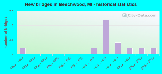
- New bridges - historical statistics
- 11900-1909
- 11960-1969
- 61970-1979
- 21980-1989
- 11990-1999
- 12000-2009
- 12010-2019


- Bridge Condition - Deck
- 50.0%Very good
- 50.0%Satisfactory

- Bridge Condition - Superstructure
- 33.3%Very good
- 33.3%Good
- 16.7%Satisfactory
- 16.7%Fair

- Bridge Condition - Substructure
- 16.7%Very good
- 83.3%Good

- Bridge Condition - Channel
- 54.5%Very good
- 27.3%Good
- 18.2%Satisfactory

- Bridge Condition - Culverts
- 33.3%Very good
- 16.7%Good
- 16.7%Satisfactory
- 33.3%Fair
Find on map >> Show street view
Structure Number: 8696, Location: 0.6 MI N OF I-196 BL (Lat: 42.804778, Lng: -86.085011), Route carried "on" structure: US 31, Year Built: 1984, Status: Open, Structure Length: 3.61m (11.84ft), Average Daily Traffic: 35,990 (year 2007), Truck Traffic: 5%, Average Future Daily Traffic: 51,200 (year 2018), Design Load: HS 25 or greater, Features Intersected: LAKEWOOD BLVD
Minimum Vertical Clearance: 30.48m (100.00ft), Kilometerpoint: 4.191, Lanes on structure: 5, Lanes under structure: 2, Base Highway Network: Yes (Inventory Route: 74, Subroute: 5), Owner: State Highway Agency, Approaching Roadway Width: 12.8m (42.0ft), Skew: 21 degrees, Material/Design: Steel, Design/Construction: Stringer/Multi-beam, Number Of Spans In Main Unit: 1, Length of Maximum Span: 35.9m (117.8ft), Curb-To-Curb Width: 30.8m (101.0ft), Out-to-Out Width: 34.8m (114.2ft)
Condition: Deck: Satisfactory, Superstructure: Good, Substructure: Good, Operating Rating: 70.3 metric tons, Method Used To Determine Operating Rating: Load Factor (LF) rating reported by rating factor (RF) method using MS18 loading, Inventory Rating: 42.1 metric tons, Method Used To Determine Inventory Rating: Load Factor (LF) rating reported by rating factor (RF) method using MS18 loading, Structural Evaluation: Better than present minimum criteria, Deck Geometry: Superior to present desirable criteria, Underclear: Meets minimum limits, Approach Roadway Alignment: Better than present minimum criteria, Designated Inspection Frequency: Every 24 months, Inspection Date: April 2020, Deck Structure Type: Concrete Cast-file-Place, Wearing Surface/Protective System: Wearing Surface: Epoxy Overlay, Deck Protection: Epoxy Coated Reinforcing
Find on map >> Show street view
Structure Number: 88, Location: SECTION 33 PARK TOWNSHIP (Lat: 42.769594, Lng: -86.197003), Route carried "on" structure: County highway 2014, Year Built: 1900, Status: Open, Structure Length: 0.67m (2.20ft), Average Daily Traffic: 1,920 (year 2020), Truck Traffic: 5%, Average Future Daily Traffic: 3,470 (year 2040), Features Intersected: MONTELLO PARK DRAIN, Facility Carried by Structure: SOUTH SHORE DRIVE
Minimum Vertical Clearance: 30.48m (100.00ft), Kilometerpoint: 0.431, Lanes on structure: 2, Owner: County Highway Agency, Approaching Roadway Width: 12.2m (40.0ft), Material/Design: Concrete, Design/Construction: Culvert, Number Of Spans In Main Unit: 3, Length of Maximum Span: 2.1m (6.9ft), Out-to-Out Width: 11.1m (36.4ft)
Condition: Channel: Very good, Culverts: Fair, Operating Rating: 40.8 metric tons, Method Used To Determine Operating Rating: Field evaluation and documented engineering judgment, Inventory Rating: 24.5 metric tons, Method Used To Determine Inventory Rating: Field evaluation and documented engineering judgment, Structural Evaluation: Somewhat better than minimum adequacy, Waterway Adequacy: Better than present minimum criteria, Approach Roadway Alignment: Equal to present minimum criteria, Designated Inspection Frequency: Every 24 months, Inspection Date: November 2020, Deck Structure Type: Concrete Cast-file-Place, Wearing Surface/Protective System: Wearing Surface: Bituminous
Find on map >> Show street view
Structure Number: 8802, Location: 0.75 MILES E OF 152ND AVE (Lat: 42.804742, Lng: -86.142753), Route carried "on" structure: County highway 2014, Year Built: 1974, Status: Open, Structure Length: 1.28m (4.20ft), Average Daily Traffic: 10,320 (year 2020), Truck Traffic: 5%, Average Future Daily Traffic: 18,640 (year 2040), Design Load: HS 20, Features Intersected: PINE CREEK, Facility Carried by Structure: LAKEWOOD BLVD
Minimum Vertical Clearance: 30.48m (100.00ft), Kilometerpoint: 5.258, Lanes on structure: 2, Owner: County Highway Agency, Approaching Roadway Width: 12.5m (41.0ft), Material/Design: Prestressed concrete, Design/Construction: Box Beam or Girders - Multiple, Number Of Spans In Main Unit: 1, Length of Maximum Span: 12.2m (40.0ft), Curb-To-Curb Width: 12.8m (42.0ft), Out-to-Out Width: 12.8m (42.0ft)
Condition: Deck: Very good, Superstructure: Very good, Substructure: Good, Channel: Good, Operating Rating: 53.1 metric tons, Method Used To Determine Operating Rating: Load Factor (LF) rating reported by rating factor (RF) method using MS18 loading, Inventory Rating: 31.8 metric tons, Method Used To Determine Inventory Rating: Load Factor (LF) rating reported by rating factor (RF) method using MS18 loading, Structural Evaluation: Better than present minimum criteria, Deck Geometry: Somewhat better than minimum adequacy, Waterway Adequacy: Equal to present desirable criteria, Approach Roadway Alignment: Equal to present desirable criteria, Designated Inspection Frequency: Every 24 months, Inspection Date: November 2020, Deck Structure Type: Concrete Precast Panels, Wearing Surface/Protective System: Wearing Surface: Bituminous, Membrane: Preformed Fabric
Find on map >> Show street view
Structure Number: 8803, Location: 0.4 MILES E OF BEELINE RD (Lat: 42.804725, Lng: -86.095747), Route carried "on" structure: County highway 2014, Year Built: 1974, Status: Open, Structure Length: 0.61m (2.00ft), Average Daily Traffic: 28,150 (year 2020), Truck Traffic: 3%, Average Future Daily Traffic: 50,800 (year 2040), Design Load: HS 20, Features Intersected: COUNTY DRAIN NO 40, Facility Carried by Structure: LAKEWOOD BLVD
Minimum Vertical Clearance: 30.48m (100.00ft), Kilometerpoint: 9.172, Lanes on structure: 4, Base Highway Network: Yes (Inventory Route: 73, Subroute: 10), Owner: County Highway Agency, Approaching Roadway Width: 20.4m (66.9ft), Material/Design: Concrete, Design/Construction: Culvert, Number Of Spans In Main Unit: 2, Length of Maximum Span: 3.0m (9.8ft), Out-to-Out Width: 19.8m (65.0ft)
Condition: Channel: Good, Culverts: Very good, Operating Rating: 51.8 metric tons, Method Used To Determine Operating Rating: Load Factor (LF) rating reported by rating factor (RF) method using MS18 loading, Inventory Rating: 31.1 metric tons, Method Used To Determine Inventory Rating: Load Factor (LF) rating reported by rating factor (RF) method using MS18 loading, Structural Evaluation: Better than present minimum criteria, Waterway Adequacy: Equal to present desirable criteria, Approach Roadway Alignment: Superior to present desirable criteria, Designated Inspection Frequency: Every 24 months, Inspection Date: September 2020, Deck Structure Type: Concrete Cast-file-Place, Wearing Surface/Protective System: Wearing Surface: Bituminous
Find on map >> Show street view
Structure Number: 8822, Location: 0.32 MILES SOUTH OF 144TH (Lat: 42.825264, Lng: -86.132561), Route carried "on" structure: County highway 2014, Year Built: 1994, Status: Open, Structure Length: 1.34m (4.40ft), Average Daily Traffic: 13,070 (year 2020), Truck Traffic: 5%, Average Future Daily Traffic: 23,600 (year 2040), Design Load: HS 20, Features Intersected: PINE CREEK, Facility Carried by Structure: BUTTERNUT DRIVE
Minimum Vertical Clearance: 30.48m (100.00ft), Kilometerpoint: 4.331, Lanes on structure: 5, Owner: County Highway Agency, Approaching Roadway Width: 17.7m (58.1ft), Material/Design: Prestressed concrete, Design/Construction: Box Beam or Girders - Multiple, Number Of Spans In Main Unit: 1, Length of Maximum Span: 12.2m (40.0ft), Curb or Sidewalk Widths: Left: 2.8m (9.2ft), Right: 0.0m, Curb-To-Curb Width: 18.9m (62.0ft), Out-to-Out Width: 20.0m (65.6ft)
Condition: Deck: Very good, Superstructure: Good, Substructure: Very good, Channel: Very good, Operating Rating: 84.2 metric tons, Method Used To Determine Operating Rating: Load Factor (LF) rating reported by rating factor (RF) method using MS18 loading, Inventory Rating: 50.2 metric tons, Method Used To Determine Inventory Rating: Load Factor (LF) rating reported by rating factor (RF) method using MS18 loading, Structural Evaluation: Better than present minimum criteria, Deck Geometry: Meets minimum limits, Waterway Adequacy: Superior to present desirable criteria, Approach Roadway Alignment: Equal to present desirable criteria, Designated Inspection Frequency: Every 24 months, Inspection Date: November 2020, Deck Structure Type: Concrete Precast Panels, Wearing Surface/Protective System: Wearing Surface: Monolithic Concrete, Deck Protection: Epoxy Coated Reinforcing
Find on map >> Show street view
Structure Number: 8885, Location: SECTION 18 HOLLAND TWP (Lat: 42.826661, Lng: -86.127581), Route carried "on" structure: County highway , Year Built: 1972, Status: Open, Structure Length: 1.00m (3.28ft), Average Daily Traffic: 13,227 (year 2019), Truck Traffic: 5%, Average Future Daily Traffic: 23,890 (year 2039), Design Load: H 20, Features Intersected: PINE CREEK, Facility Carried by Structure: RILEY ST
Minimum Vertical Clearance: 30.48m (100.00ft), Kilometerpoint: 6.813, Lanes on structure: 2, Owner: County Highway Agency, Approaching Roadway Width: 8.5m (27.9ft), Skew: 2 degrees, Material/Design: Steel, Design/Construction: Stringer/Multi-beam, Number Of Spans In Main Unit: 1, Length of Maximum Span: 9.4m (30.8ft), Curb-To-Curb Width: 10.1m (33.1ft), Out-to-Out Width: 11.0m (36.1ft)
Condition: Deck: Satisfactory, Superstructure: Fair, Substructure: Good, Channel: Satisfactory, Operating Rating: 50.5 metric tons, Method Used To Determine Operating Rating: Load Factor (LF) rating reported by rating factor (RF) method using MS18 loading, Inventory Rating: 30.1 metric tons, Method Used To Determine Inventory Rating: Load Factor (LF) rating reported by rating factor (RF) method using MS18 loading, Structural Evaluation: Somewhat better than minimum adequacy, Deck Geometry: Meets minimum limits, Waterway Adequacy: Equal to present desirable criteria, Approach Roadway Alignment: Better than present minimum criteria, Designated Inspection Frequency: Every 24 months, Inspection Date: November 2020, Deck Structure Type: Concrete Cast-file-Place, Wearing Surface/Protective System: Wearing Surface: Monolithic Concrete
Find on map >> Show street view
Structure Number: 8887, Location: SECTION 7 HOLLAND TWP (Lat: 42.841175, Lng: -86.129525), Route carried "on" structure: County highway , Year Built: 1972, Status: Open, Structure Length: 0.73m (2.40ft), Average Daily Traffic: 6,970 (year 2020), Truck Traffic: 5%, Average Future Daily Traffic: 12,590 (year 2040), Design Load: H 20, Features Intersected: PINE CREEK, Facility Carried by Structure: QUINCY STREET
Minimum Vertical Clearance: 30.48m (100.00ft), Kilometerpoint: 6.404, Lanes on structure: 2, Owner: County Highway Agency, Approaching Roadway Width: 7.9m (25.9ft), Material/Design: Wood or Timber, Design/Construction: Culvert, Number Of Spans In Main Unit: 3, Length of Maximum Span: 2.1m (6.9ft), Out-to-Out Width: 14.0m (45.9ft)
Condition: Channel: Very good, Culverts: Satisfactory, Operating Rating: 51.5 metric tons, Method Used To Determine Operating Rating: Allowable Stress (AS) rating reported by rating factor (RF) method using MS18 loading, Inventory Rating: 35.0 metric tons, Method Used To Determine Inventory Rating: Allowable Stress (AS) rating reported by rating factor (RF) method using MS18 loading, Structural Evaluation: Equal to present minimum criteria, Waterway Adequacy: Better than present minimum criteria, Approach Roadway Alignment: Better than present minimum criteria, Designated Inspection Frequency: Every 24 months, Inspection Date: November 2020, Wearing Surface/Protective System: Wearing Surface: Bituminous
Find on map >> Show street view
Structure Number: 8889, Location: SECTION 18 HOLLAND TWP (Lat: 42.818175, Lng: -86.137806), Route carried "on" structure: County highway , Year Built: 1978, Status: Open, Structure Length: 1.06m (3.48ft), Average Daily Traffic: 5,395 (year 2019), Truck Traffic: 5%, Average Future Daily Traffic: 9,740 (year 2039), Design Load: HS 20, Features Intersected: PINE CREEK, Facility Carried by Structure: 144TH AVE
Minimum Vertical Clearance: 30.48m (100.00ft), Kilometerpoint: 3.393, Lanes on structure: 2, Owner: County Highway Agency, Approaching Roadway Width: 11.0m (36.1ft), Material/Design: Prestressed concrete, Design/Construction: Box Beam or Girders - Multiple, Number Of Spans In Main Unit: 1, Length of Maximum Span: 10.0m (32.8ft), Curb-To-Curb Width: 11.0m (36.1ft), Out-to-Out Width: 11.1m (36.4ft)
Condition: Deck: Very good, Superstructure: Very good, Substructure: Good, Channel: Good, Operating Rating: 50.9 metric tons, Method Used To Determine Operating Rating: Load Factor (LF) rating reported by rating factor (RF) method using MS18 loading, Inventory Rating: 30.5 metric tons, Method Used To Determine Inventory Rating: Load Factor (LF) rating reported by rating factor (RF) method using MS18 loading, Structural Evaluation: Better than present minimum criteria, Deck Geometry: Meets minimum limits, Waterway Adequacy: Equal to present desirable criteria, Approach Roadway Alignment: Equal to present desirable criteria, Designated Inspection Frequency: Every 24 months, Inspection Date: November 2020, Deck Structure Type: Concrete Precast Panels, Wearing Surface/Protective System: Wearing Surface: Bituminous, Membrane: Preformed Fabric
Find on map >> Show street view
Structure Number: 889, Location: SECTION 6 HOLLAND TWP (Lat: 42.848008, Lng: -86.138033), Route carried "on" structure: County highway , Year Built: 2013, Status: Open, Structure Length: 2.01m (6.59ft), Average Daily Traffic: 3,123 (year 2019), Truck Traffic: 5%, Average Future Daily Traffic: 5,640 (year 2039), Design Load: HS 20, Features Intersected: HARLEM DRAIN, Facility Carried by Structure: 144TH AVENUE
Minimum Vertical Clearance: 30.48m (100.00ft), Kilometerpoint: 6.706, Lanes on structure: 2, Owner: County Highway Agency, Approaching Roadway Width: 7.9m (25.9ft), Skew: 3 degrees, Material/Design: Steel, Design/Construction: Culvert, Number Of Spans In Main Unit: 3, Length of Maximum Span: 2.8m (9.2ft), Out-to-Out Width: 11.0m (36.1ft)
Condition: Channel: Very good, Culverts: Good, Operating Rating: 65.4 metric tons, Method Used To Determine Operating Rating: Load and Resistance Factor Rating (LRFR) rating reported by rating factor(RF) method using HL-93 loadings, Inventory Rating: 50.5 metric tons, Method Used To Determine Inventory Rating: Load and Resistance Factor Rating (LRFR) rating reported by rating factor(RF) method using HL-93 loadings, Structural Evaluation: Better than present minimum criteria, Waterway Adequacy: Equal to present desirable criteria, Approach Roadway Alignment: Equal to present desirable criteria, Designated Inspection Frequency: Every 24 months, Inspection Date: November 2020, Wearing Surface/Protective System: Wearing Surface: Bituminous
Find on map >> Show street view
Structure Number: 89, Location: SECTION 31 OLIVE TWP (Lat: 42.870772, Lng: -86.139253), Route carried "on" structure: County highway , Year Built: 1973, Status: Open, Structure Length: 0.73m (2.40ft), Average Daily Traffic: 2,526 (year 2019), Truck Traffic: 5%, Average Future Daily Traffic: 4,560 (year 2039), Design Load: H 20, Features Intersected: CRANBERRY DRAIN, Facility Carried by Structure: 144TH AVENUE
Minimum Vertical Clearance: 30.48m (100.00ft), Kilometerpoint: 9.238, Lanes on structure: 2, Owner: County Highway Agency, Approaching Roadway Width: 9.8m (32.2ft), Skew: 4 degrees, Material/Design: Wood or Timber, Design/Construction: Culvert, Number Of Spans In Main Unit: 3, Length of Maximum Span: 2.1m (6.9ft), Out-to-Out Width: 21.3m (69.9ft)
Condition: Channel: Satisfactory, Culverts: Fair, Operating Rating: 45.4 metric tons, Method Used To Determine Operating Rating: Allowable Stress (AS) rating reported by rating factor (RF) method using MS18 loading, Inventory Rating: 31.8 metric tons, Method Used To Determine Inventory Rating: Allowable Stress (AS) rating reported by rating factor (RF) method using MS18 loading, Structural Evaluation: Somewhat better than minimum adequacy, Waterway Adequacy: Equal to present desirable criteria, Approach Roadway Alignment: Equal to present minimum criteria, Designated Inspection Frequency: Every 24 months, Inspection Date: November 2020, Wearing Surface/Protective System: Wearing Surface: Bituminous
Find on map >> Show street view
Structure Number: 8907, Location: SECTION 24 PARK TWP (Lat: 42.811958, Lng: -86.149878), Route carried "on" structure: County highway , Year Built: 1960, Status: Open, Structure Length: 0.94m (3.08ft), Average Daily Traffic: 6,280 (year 2020), Truck Traffic: 5%, Average Future Daily Traffic: 11,340 (year 2040), Design Load: H 20, Features Intersected: PINE CREEK, Facility Carried by Structure: JAMES ST
Minimum Vertical Clearance: 30.48m (100.00ft), Kilometerpoint: 4.807, Lanes on structure: 2, Owner: County Highway Agency, Approaching Roadway Width: 9.8m (32.2ft), Material/Design: Prestressed concrete, Design/Construction: Box Beam or Girders - Multiple, Number Of Spans In Main Unit: 1, Length of Maximum Span: 9.1m (29.9ft), Curb-To-Curb Width: 9.1m (29.9ft), Out-to-Out Width: 9.3m (30.5ft)
Condition: Deck: Satisfactory, Superstructure: Satisfactory, Substructure: Good, Channel: Very good, Operating Rating: 62.5 metric tons, Method Used To Determine Operating Rating: Load and Resistance Factor Rating (LRFR) rating reported by rating factor(RF) method using HL-93 loadings, Inventory Rating: 48.3 metric tons, Method Used To Determine Inventory Rating: Load and Resistance Factor Rating (LRFR) rating reported by rating factor(RF) method using HL-93 loadings, Structural Evaluation: Equal to present minimum criteria, Deck Geometry: High priority of corrective action, Waterway Adequacy: Equal to present minimum criteria, Approach Roadway Alignment: Better than present minimum criteria, Designated Inspection Frequency: Every 24 months, Inspection Date: November 2020, Deck Structure Type: Concrete Precast Panels, Wearing Surface/Protective System: Wearing Surface: Bituminous, Membrane: Preformed Fabric
Find on map >> Show street view
Structure Number: 13266, Location: PARK TWP SEC 33 (Lat: 42.767708, Lng: -86.197447), Route carried "on" structure: County highway 2014, Year Built: 2002, Status: Open, Structure Length: 0.61m (2.00ft), Average Daily Traffic: 1,500 (year 2019), Truck Traffic: 5%, Average Future Daily Traffic: 2,710 (year 2039), Design Load: HS 20, Features Intersected: KELLY LAKE DRAIN, Facility Carried by Structure: 32ND STREET
Minimum Vertical Clearance: 30.48m (100.00ft), Kilometerpoint: 0.193, Lanes on structure: 2, Owner: County Highway Agency, Approaching Roadway Width: 9.8m (32.2ft), Material/Design: Concrete, Design/Construction: Culvert, Number Of Spans In Main Unit: 1, Length of Maximum Span: 6.1m (20.0ft), Curb-To-Curb Width: 9.8m (32.2ft), Out-to-Out Width: 12.2m (40.0ft)
Condition: Channel: Very good, Culverts: Very good, Operating Rating: 42.4 metric tons, Method Used To Determine Operating Rating: Load and Resistance Factor Rating (LRFR) rating reported by rating factor(RF) method using HL-93 loadings, Inventory Rating: 32.7 metric tons, Method Used To Determine Inventory Rating: Load and Resistance Factor Rating (LRFR) rating reported by rating factor(RF) method using HL-93 loadings, Structural Evaluation: Equal to present desirable criteria, Deck Geometry: Somewhat better than minimum adequacy, Waterway Adequacy: Better than present minimum criteria, Approach Roadway Alignment: Equal to present desirable criteria, Designated Inspection Frequency: Every 24 months, Inspection Date: November 2020
Find on map >> Show street view
Structure Number: 8696, Location: 0.6 MI N OF I-196 BL (Lat: 42.804778, Lng: -86.085011), Route carried "under" structure: County highway 2014, Year Built: 1984, Structure Length: 0. m, Average Daily Traffic: 18,000 (year 1995), Truck Traffic: 1%, Features Intersected: LAKEWOOD BLVD, Facility Carried by Structure: US-31
Minimum Vertical Clearance: 4.50m (14.76ft), Kilometerpoint: 10.051, Lanes on structure: 5, Lanes under structure: 2, Material/Design: Steel, Design/Construction: Stringer/Multi-beam, Length of Maximum Span: 35.9m (117.8ft)