Bridge Statistics for Beaverton, Michigan (MI)
Condition, Traffic, Stress, Structural Evaluation, Project Costs
- National Bridge Inventory (NBI) Statistics
- 14Number of bridges
- 138ft / 42.4mTotal length
- 11,307Total average daily traffic
- 501Total average daily truck traffic
- 16,294Total future (year 2018) average daily traffic
- National Bridge Inventory (NBI) Registered Bridges for Beaverton
- No street view available for this location
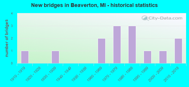
- New bridges - historical statistics
- 11910-1919
- 11930-1939
- 21960-1969
- 31970-1979
- 31980-1989
- 11990-1999
- 12000-2009
- 22010-2019


- Bridge Condition - Deck
- 16.7%Very good
- 33.3%Good
- 25.0%Satisfactory
- 8.3%Fair
- 16.7%Poor

- Bridge Condition - Superstructure
- 7.7%Excellent
- 15.4%Very good
- 46.2%Good
- 15.4%Satisfactory
- 15.4%Fair

- Bridge Condition - Substructure
- 15.4%Very good
- 38.5%Good
- 23.1%Satisfactory
- 23.1%Fair

- Bridge Condition - Channel
- 7.1%Very good
- 64.3%Good
- 28.6%Satisfactory
Find on map >> Show street view
Structure Number: 2871, Location: IN BEAVERTON (Lat: 43.884322, Lng: -84.486164), Route carried "on" structure: State highway 18, Year Built: 1939, Status: Open, Structure Length: 8.68m (28.48ft), Average Daily Traffic: 6,100 (year 2011), Truck Traffic: 3%, Average Future Daily Traffic: 8,873 (year 2018), Design Load: H 20, Features Intersected: TOBACCO RIVER
Minimum Vertical Clearance: 30.48m (100.00ft), Kilometerpoint: 7.865, Lanes on structure: 2, Base Highway Network: Yes (Inventory Route: 111, Subroute: 5), Owner: State Highway Agency, Approaching Roadway Width: 12.8m (42.0ft), Material/Design: Steel, Design/Construction: Stringer/Multi-beam, Number Of Spans In Main Unit: 6, Length of Maximum Span: 15.2m (49.9ft), Curb or Sidewalk Widths: Left: 1.0m (3.3ft), Right: 1.0m (3.3ft), Curb-To-Curb Width: 12.8m (42.0ft), Out-to-Out Width: 15.6m (51.2ft)
Condition: Deck: Poor, Superstructure: Fair, Substructure: Fair, Channel: Very good, Operating Rating: 52.8 metric tons, Method Used To Determine Operating Rating: Load Factor (LF) rating reported by rating factor (RF) method using MS18 loading, Inventory Rating: 27.5 metric tons, Method Used To Determine Inventory Rating: Load Factor (LF) rating reported by rating factor (RF) method using MS18 loading, Structural Evaluation: Somewhat better than minimum adequacy, Deck Geometry: Somewhat better than minimum adequacy, Waterway Adequacy: Equal to present desirable criteria, Approach Roadway Alignment: Equal to present desirable criteria, Designated Inspection Frequency: Every 24 months, Underwater Inspection Frequency: Every 60 months, Inspection Date: May 2020, Underwater Inspection Date: August 2020, Deck Structure Type: Concrete Cast-file-Place, Wearing Surface/Protective System: Wearing Surface: Epoxy Overlay
Find on map >> Show street view
Structure Number: 2894, Location: 2.9 MI E OF M18 (Lat: 43.857553, Lng: -84.428614), Route carried "on" structure: County highway 2616, Year Built: 1970, Status: Open, Structure Length: 6.09m (19.98ft), Average Daily Traffic: 585 (year 2000), Truck Traffic: 7%, Average Future Daily Traffic: 819 (year 2020), Design Load: HS 20+Mod, Features Intersected: TOBACCO RIVER, Facility Carried by Structure: DALE ROAD
Minimum Vertical Clearance: 30.48m (100.00ft), Kilometerpoint: 13.081, Lanes on structure: 2, Owner: County Highway Agency, Approaching Roadway Width: 9.8m (32.2ft), Material/Design: Steel, Design/Construction: Stringer/Multi-beam, Number Of Spans In Main Unit: 3, Length of Maximum Span: 23.7m (77.8ft), Curb-To-Curb Width: 9.1m (29.9ft), Out-to-Out Width: 10.3m (33.8ft)
Condition: Deck: Poor, Superstructure: Good, Substructure: Fair, Channel: Good, Operating Rating: 65.1 metric tons, Method Used To Determine Operating Rating: Load Factor (LF) rating reported by rating factor (RF) method using MS18 loading, Inventory Rating: 39.2 metric tons, Method Used To Determine Inventory Rating: Load Factor (LF) rating reported by rating factor (RF) method using MS18 loading, Structural Evaluation: Somewhat better than minimum adequacy, Deck Geometry: Equal to present minimum criteria, Waterway Adequacy: Equal to present desirable criteria, Approach Roadway Alignment: Equal to present desirable criteria, Designated Inspection Frequency: Every 24 months, Inspection Date: March 2020, Deck Structure Type: Concrete Cast-file-Place, Wearing Surface/Protective System: Wearing Surface: Monolithic Concrete
Find on map >> Show street view
Structure Number: 2896, Location: 1 MI W OF BEAVERTON (Lat: 43.872664, Lng: -84.542036), Route carried "on" structure: County highway 2620, Year Built: 1986, Status: Open, Structure Length: 2.43m (7.97ft), Average Daily Traffic: 880 (year 2000), Truck Traffic: 10%, Average Future Daily Traffic: 1,232 (year 2020), Design Load: HS 20+Mod, Features Intersected: S BR OF TOBACCO RIV, Facility Carried by Structure: BEAVERTON RD
Minimum Vertical Clearance: 30.48m (100.00ft), Kilometerpoint: 5.158, Lanes on structure: 2, Owner: County Highway Agency, Approaching Roadway Width: 8.5m (27.9ft), Material/Design: Prestressed concrete, Design/Construction: Box Beam or Girders - Multiple, Number Of Spans In Main Unit: 1, Length of Maximum Span: 24.3m (79.7ft), Curb-To-Curb Width: 11.6m (38.1ft), Out-to-Out Width: 12.3m (40.4ft)
Condition: Superstructure: Good, Substructure: Satisfactory, Channel: Good, Operating Rating: 64.5 metric tons, Method Used To Determine Operating Rating: Load Factor (LF) rating reported by rating factor (RF) method using MS18 loading, Inventory Rating: 35.6 metric tons, Method Used To Determine Inventory Rating: Load Factor (LF) rating reported by rating factor (RF) method using MS18 loading, Structural Evaluation: Equal to present minimum criteria, Deck Geometry: Better than present minimum criteria, Waterway Adequacy: Equal to present desirable criteria, Approach Roadway Alignment: Equal to present desirable criteria, Designated Inspection Frequency: Every 24 months, Inspection Date: March 2020, Deck Structure Type: Concrete Precast Panels, Wearing Surface/Protective System: Wearing Surface: Bituminous, Membrane: Preformed Fabric, Deck Protection: Epoxy Coated Reinforcing
Find on map >> Show street view
Structure Number: 29, Location: 0.75 MI W OF M18 (Lat: 43.901722, Lng: -84.521858), Route carried "on" structure: County highway 2624, Year Built: 1968, Status: Open, Structure Length: 1.92m (6.30ft), Average Daily Traffic: 440 (year 2000), Truck Traffic: 7%, Average Future Daily Traffic: 616 (year 2020), Design Load: HS 20+Mod, Features Intersected: N BR OF TOBACCO R, Facility Carried by Structure: CALHOUN RD
Minimum Vertical Clearance: 30.48m (100.00ft), Kilometerpoint: 8.388, Lanes on structure: 2, Owner: County Highway Agency, Approaching Roadway Width: 8.5m (27.9ft), Skew: 4 degrees, Material/Design: Steel, Design/Construction: Stringer/Multi-beam, Number Of Spans In Main Unit: 1, Length of Maximum Span: 18.2m (59.7ft), Curb-To-Curb Width: 7.3m (24.0ft), Out-to-Out Width: 8.3m (27.2ft)
Condition: Deck: Satisfactory, Superstructure: Satisfactory, Substructure: Fair, Channel: Satisfactory, Operating Rating: 71.6 metric tons, Method Used To Determine Operating Rating: Load Factor (LF), Inventory Rating: 42.8 metric tons, Method Used To Determine Inventory Rating: Load Factor (LF), Structural Evaluation: Somewhat better than minimum adequacy, Deck Geometry: Meets minimum limits, Waterway Adequacy: Equal to present desirable criteria, Approach Roadway Alignment: Equal to present desirable criteria, Designated Inspection Frequency: Every 24 months, Inspection Date: March 2020, Deck Structure Type: Concrete Cast-file-Place, Wearing Surface/Protective System: Wearing Surface: Bituminous
Find on map >> Show street view
Structure Number: 2901, Location: 1.3 MI E OF M 18 (Lat: 43.915775, Lng: -84.478889), Route carried "on" structure: County highway 2630, Year Built: 1975, Status: Open, Structure Length: 2.19m (7.19ft), Average Daily Traffic: 205 (year 2000), Truck Traffic: 5%, Average Future Daily Traffic: 287 (year 2020), Design Load: HS 20+Mod, Features Intersected: CEDAR RIVER, Facility Carried by Structure: HOWARD RD
Minimum Vertical Clearance: 30.48m (100.00ft), Kilometerpoint: 5.314, Lanes on structure: 2, Owner: County Highway Agency, Approaching Roadway Width: 8.5m (27.9ft), Material/Design: Prestressed concrete, Design/Construction: Box Beam or Girders - Multiple, Number Of Spans In Main Unit: 1, Length of Maximum Span: 20.7m (67.9ft), Curb-To-Curb Width: 9.8m (32.2ft), Out-to-Out Width: 11.1m (36.4ft)
Condition: Deck: Satisfactory, Superstructure: Good, Substructure: Good, Channel: Good, Operating Rating: 59.3 metric tons, Method Used To Determine Operating Rating: Load Factor (LF) rating reported by rating factor (RF) method using MS18 loading, Inventory Rating: 45.7 metric tons, Method Used To Determine Inventory Rating: Load Factor (LF) rating reported by rating factor (RF) method using MS18 loading, Structural Evaluation: Better than present minimum criteria, Deck Geometry: Better than present minimum criteria, Waterway Adequacy: Equal to present desirable criteria, Approach Roadway Alignment: Equal to present desirable criteria, Designated Inspection Frequency: Every 24 months, Inspection Date: March 2020, Deck Structure Type: Concrete Precast Panels, Wearing Surface/Protective System: Wearing Surface: Integral Concrete
Find on map >> Show street view
Structure Number: 291, Location: 4 1/2 MILES S OF M61 (Lat: 43.916881, Lng: -84.545133), Route carried "on" structure: County highway , Year Built: 1977, Status: Open, Structure Length: 1.09m (3.58ft), Average Daily Traffic: 215 (year 2000), Truck Traffic: 5%, Average Future Daily Traffic: 301 (year 2020), Design Load: HS 20+Mod, Features Intersected: N BR TOBACCO RIVER, Facility Carried by Structure: GROUT RD
Minimum Vertical Clearance: 30.48m (100.00ft), Kilometerpoint: 1.648, Lanes on structure: 2, Owner: County Highway Agency, Approaching Roadway Width: 9.1m (29.9ft), Material/Design: Concrete, Design/Construction: Culvert, Number Of Spans In Main Unit: 2, Length of Maximum Span: 4.8m (15.7ft)
Condition: Channel: Satisfactory, Culverts: Satisfactory, Operating Rating: 97.2 metric tons, Method Used To Determine Operating Rating: Load Factor (LF) rating reported by rating factor (RF) method using MS18 loading, Inventory Rating: 68.0 metric tons, Method Used To Determine Inventory Rating: Load Factor (LF) rating reported by rating factor (RF) method using MS18 loading, Structural Evaluation: Equal to present minimum criteria, Waterway Adequacy: Better than present minimum criteria, Approach Roadway Alignment: Better than present minimum criteria, Designated Inspection Frequency: Every 24 months, Inspection Date: March 2020, Deck Structure Type: Concrete Precast Panels, Wearing Surface/Protective System: Wearing Surface: Bituminous
Find on map >> Show street view
Structure Number: 2911, Location: 40 RODS N OF LANG RD (Lat: 43.888875, Lng: -84.525292), Route carried "on" structure: County highway , Year Built: 1964, Status: Open, Structure Length: 0.91m (2.99ft), Average Daily Traffic: 210 (year 2000), Truck Traffic: 5%, Average Future Daily Traffic: 294 (year 2020), Design Load: HS 20+Mod, Features Intersected: MIDDLE BR TOBACCO RIVER, Facility Carried by Structure: MCCULLOUGH RD
Minimum Vertical Clearance: 30.48m (100.00ft), Kilometerpoint: 1.849, Lanes on structure: 2, Owner: County Highway Agency, Approaching Roadway Width: 6.1m (20.0ft), Material/Design: Steel, Design/Construction: Stringer/Multi-beam, Number Of Spans In Main Unit: 1, Length of Maximum Span: 8.2m (26.9ft), Curb-To-Curb Width: 7.3m (24.0ft), Out-to-Out Width: 8.3m (27.2ft)
Condition: Deck: Good, Superstructure: Good, Substructure: Good, Channel: Satisfactory, Operating Rating: 46.0 metric tons, Method Used To Determine Operating Rating: Load Factor (LF), Inventory Rating: 27.5 metric tons, Method Used To Determine Inventory Rating: Load Factor (LF), Structural Evaluation: Equal to present minimum criteria, Deck Geometry: Somewhat better than minimum adequacy, Waterway Adequacy: Equal to present minimum criteria, Approach Roadway Alignment: Equal to present desirable criteria, Designated Inspection Frequency: Every 24 months, Inspection Date: March 2020, Deck Structure Type: Concrete Cast-file-Place, Wearing Surface/Protective System: Wearing Surface: Bituminous
Find on map >> Show street view
Structure Number: 2915, Location: 30 RODS E OF MCCULLOUGH (Lat: 43.887036, Lng: -84.523500), Route carried "on" structure: County highway , Year Built: 2007, Status: Open, Structure Length: 1.28m (4.20ft), Average Daily Traffic: 187 (year 2007), Truck Traffic: 5%, Average Future Daily Traffic: 270 (year 2026), Design Load: HS 20+Mod, Features Intersected: MIDDLE BR TOBACCO RIVER, Facility Carried by Structure: LANG RD
Minimum Vertical Clearance: 30.48m (100.00ft), Kilometerpoint: 6.648, Lanes on structure: 2, Owner: County Highway Agency, Approaching Roadway Width: 8.5m (27.9ft), Material/Design: Prestressed concrete, Design/Construction: Box Beam or Girders - Multiple, Number Of Spans In Main Unit: 1, Length of Maximum Span: 12.4m (40.7ft), Curb-To-Curb Width: 10.4m (34.1ft), Out-to-Out Width: 11.4m (37.4ft)
Condition: Deck: Good, Superstructure: Very good, Substructure: Good, Channel: Good, Operating Rating: 38.5 metric tons, Method Used To Determine Operating Rating: Load Factor (LF), Inventory Rating: 23.0 metric tons, Method Used To Determine Inventory Rating: Load Factor (LF), Structural Evaluation: Equal to present minimum criteria, Deck Geometry: Better than present minimum criteria, Waterway Adequacy: Superior to present desirable criteria, Approach Roadway Alignment: Equal to present desirable criteria, Designated Inspection Frequency: Every 24 months, Inspection Date: March 2020, Deck Structure Type: Concrete Precast Panels, Wearing Surface/Protective System: Wearing Surface: Bituminous, Membrane: Preformed Fabric
Find on map >> Show street view
Structure Number: 2916, Location: 170 RODS S BEAVERTON RD (Lat: 43.866925, Lng: -84.545567), Route carried "on" structure: County highway , Year Built: 2013, Status: Open, Structure Length: 2.74m (8.99ft), Average Daily Traffic: 100 (year 2013), Truck Traffic: 3%, Average Future Daily Traffic: 294 (year 2020), Design Load: Greater than HL93, Features Intersected: S BR OF TOBACCO, Facility Carried by Structure: TOWNHALL RD
Minimum Vertical Clearance: 30.48m (100.00ft), Kilometerpoint: 4.204, Lanes on structure: 2, Owner: County Highway Agency, Approaching Roadway Width: 9.8m (32.2ft), Material/Design: Prestressed concrete, Design/Construction: Stringer/Multi-beam, Number Of Spans In Main Unit: 1, Length of Maximum Span: 26.5m (86.9ft), Curb-To-Curb Width: 9.8m (32.2ft), Out-to-Out Width: 10.5m (34.4ft)
Condition: Deck: Very good, Superstructure: Excellent, Substructure: Very good, Channel: Good, Operating Rating: 49.9 metric tons, Method Used To Determine Operating Rating: Load and Resistance Factor Rating (LRFR) rating reported by rating factor(RF) method using HL-93 loadings, Inventory Rating: 39.5 metric tons, Method Used To Determine Inventory Rating: Load and Resistance Factor Rating (LRFR) rating reported by rating factor(RF) method using HL-93 loadings, Structural Evaluation: Equal to present desirable criteria, Deck Geometry: Equal to present desirable criteria, Waterway Adequacy: Equal to present minimum criteria, Approach Roadway Alignment: Equal to present desirable criteria, Designated Inspection Frequency: Every 24 months, Inspection Date: March 2020, Deck Structure Type: Concrete Cast-file-Place, Wearing Surface/Protective System: Wearing Surface: Bituminous, Deck Protection: Epoxy Coated Reinforcing
Find on map >> Show street view
Structure Number: 2917, Location: 175 RODS E OF M18 (Lat: 43.879611, Lng: -84.474086), Route carried "on" structure: County highway , Year Built: 1987, Status: Open, Structure Length: 4.48m (14.70ft), Average Daily Traffic: 330 (year 2000), Truck Traffic: 7%, Average Future Daily Traffic: 462 (year 2020), Design Load: HS 20+Mod, Features Intersected: TOBACCO RIVER, Facility Carried by Structure: GLIDDEN RD
Minimum Vertical Clearance: 30.48m (100.00ft), Kilometerpoint: 0.903, Lanes on structure: 2, Owner: County Highway Agency, Approaching Roadway Width: 6.7m (22.0ft), Material/Design: Prestressed concrete, Design/Construction: Box Beam or Girders - Multiple, Number Of Spans In Main Unit: 3, Length of Maximum Span: 14.9m (48.9ft), Curb-To-Curb Width: 10.4m (34.1ft), Out-to-Out Width: 11.3m (37.1ft)
Condition: Deck: Satisfactory, Superstructure: Satisfactory, Substructure: Satisfactory, Channel: Good, Operating Rating: 58.6 metric tons, Method Used To Determine Operating Rating: Load Factor (LF), Inventory Rating: 35.2 metric tons, Method Used To Determine Inventory Rating: Load Factor (LF), Structural Evaluation: Equal to present minimum criteria, Deck Geometry: Better than present minimum criteria, Waterway Adequacy: Equal to present minimum criteria, Approach Roadway Alignment: Equal to present desirable criteria, Designated Inspection Frequency: Every 24 months, Inspection Date: March 2020, Deck Structure Type: Concrete Precast Panels, Wearing Surface/Protective System: Wearing Surface: Bituminous, Membrane: Preformed Fabric, Deck Protection: Epoxy Coated Reinforcing
Find on map >> Show street view
Structure Number: 2918, Location: 120 RODS N OF GUERNSEY RD (Lat: 43.848700, Lng: -84.466361), Route carried "on" structure: County highway , Year Built: 2014, Status: Open, Structure Length: 0.91m (2.99ft), Average Daily Traffic: 115 (year 2013), Truck Traffic: 5%, Average Future Daily Traffic: 171 (year 2033), Design Load: HS 20, Features Intersected: BEAR DRAIN, Facility Carried by Structure: PETERSON RD
Minimum Vertical Clearance: 30.48m (100.00ft), Kilometerpoint: 0.592, Lanes on structure: 2, Owner: County Highway Agency, Approaching Roadway Width: 9.8m (32.2ft), Skew: 1 degrees, Material/Design: Prestressed concrete, Design/Construction: Box Beam or Girders - Single/Spread, Number Of Spans In Main Unit: 1, Length of Maximum Span: 8.7m (28.5ft), Curb-To-Curb Width: 9.8m (32.2ft), Out-to-Out Width: 10.7m (35.1ft)
Condition: Deck: Very good, Superstructure: Very good, Substructure: Good, Channel: Good, Operating Rating: 54.8 metric tons, Method Used To Determine Operating Rating: Load and Resistance Factor Rating (LRFR) rating reported by rating factor(RF) method using HL-93 loadings, Inventory Rating: 43.1 metric tons, Method Used To Determine Inventory Rating: Load and Resistance Factor Rating (LRFR) rating reported by rating factor(RF) method using HL-93 loadings, Structural Evaluation: Better than present minimum criteria, Deck Geometry: Better than present minimum criteria, Waterway Adequacy: Somewhat better than minimum adequacy, Approach Roadway Alignment: Equal to present desirable criteria, Designated Inspection Frequency: Every 24 months, Inspection Date: March 2020, Deck Structure Type: Concrete Cast-file-Place, Wearing Surface/Protective System: Wearing Surface: Monolithic Concrete, Deck Protection: Epoxy Coated Reinforcing
Find on map >> Show street view
Structure Number: 2924, Location: 20 RODS E OF GROUT RD (Lat: 43.915536, Lng: -84.542744), Route carried "on" structure: County highway , Year Built: 1988, Status: Open, Structure Length: 1.83m (6.00ft), Average Daily Traffic: 210 (year 2017), Truck Traffic: 5%, Average Future Daily Traffic: 220 (year 2037), Design Load: HS 20+Mod, Features Intersected: N BR TOBACCO RIVER, Facility Carried by Structure: HOWARD RD
Minimum Vertical Clearance: 30.48m (100.00ft), Kilometerpoint: 0.187, Lanes on structure: 2, Owner: County Highway Agency, Approaching Roadway Width: 8.5m (27.9ft), Skew: 3 degrees, Material/Design: Prestressed concrete, Design/Construction: Box Beam or Girders - Multiple, Number Of Spans In Main Unit: 1, Length of Maximum Span: 18.2m (59.7ft), Curb-To-Curb Width: 8.5m (27.9ft), Out-to-Out Width: 9.5m (31.2ft)
Condition: Deck: Good, Superstructure: Good, Substructure: Very good, Channel: Satisfactory, Operating Rating: 48.0 metric tons, Method Used To Determine Operating Rating: Load Factor (LF) rating reported by rating factor (RF) method using MS18 loading, Inventory Rating: 36.9 metric tons, Method Used To Determine Inventory Rating: Load Factor (LF) rating reported by rating factor (RF) method using MS18 loading, Structural Evaluation: Better than present minimum criteria, Deck Geometry: Equal to present minimum criteria, Waterway Adequacy: Equal to present desirable criteria, Approach Roadway Alignment: Equal to present desirable criteria, Designated Inspection Frequency: Every 24 months, Inspection Date: March 2020, Deck Structure Type: Concrete Precast Panels, Wearing Surface/Protective System: Wearing Surface: Bituminous, Membrane: Preformed Fabric
Find on map >> Show street view
Structure Number: 2927, Location: 70 RODS N OF CALHOUN RD (Lat: 43.905022, Lng: -84.524772), Route carried "on" structure: County highway , Year Built: 1991, Status: Open, Structure Length: 1.83m (6.00ft), Average Daily Traffic: 260 (year 2017), Truck Traffic: 3%, Average Future Daily Traffic: 270 (year 2037), Design Load: HS 20, Features Intersected: N BR TOBACCO RIVER, Facility Carried by Structure: MCCULLOCH RD
Minimum Vertical Clearance: 30.48m (100.00ft), Kilometerpoint: 3.644, Lanes on structure: 2, Owner: County Highway Agency, Approaching Roadway Width: 8.5m (27.9ft), Skew: 4 degrees, Material/Design: Prestressed concrete, Design/Construction: Box Beam or Girders - Multiple, Number Of Spans In Main Unit: 1, Length of Maximum Span: 17.0m (55.8ft), Curb-To-Curb Width: 8.5m (27.9ft), Out-to-Out Width: 9.5m (31.2ft)
Condition: Deck: Good, Superstructure: Good, Substructure: Good, Channel: Good, Operating Rating: 45.4 metric tons, Method Used To Determine Operating Rating: Field evaluation and documented engineering judgment, Inventory Rating: 34.9 metric tons, Method Used To Determine Inventory Rating: Field evaluation and documented engineering judgment, Structural Evaluation: Better than present minimum criteria, Deck Geometry: Equal to present minimum criteria, Waterway Adequacy: Superior to present desirable criteria, Approach Roadway Alignment: Equal to present desirable criteria, Designated Inspection Frequency: Every 24 months, Inspection Date: March 2020, Deck Structure Type: Concrete Precast Panels, Wearing Surface/Protective System: Wearing Surface: Bituminous, Membrane: Preformed Fabric
Find on map >> Show street view
Structure Number: 2942, Location: 0.1 MILES EAST OF M-18 (Lat: 43.883653, Lng: -84.483589), Route carried "on" structure: City street 2620, Year Built: 1917, Year Reconstructed: 1959, Status: Posted for load, Structure Length: 6.05m (19.85ft), Average Daily Traffic: 1,470 (year 2017), Truck Traffic: 5%, Average Future Daily Traffic: 2,185 (year 2037), Design Load: H 20, Features Intersected: TOBACCO RIVER, Facility Carried by Structure: PORTER STREET
Minimum Vertical Clearance: 30.48m (100.00ft), Kilometerpoint: 0.146, Lanes on structure: 2, Owner: City or Municipal Highway Agency, Approaching Roadway Width: 7.1m (23.3ft), Material/Design: Prestressed concrete, Design/Construction: Box Beam or Girders - Multiple, Number Of Spans In Main Unit: 4, Length of Maximum Span: 15.5m (50.9ft), Curb or Sidewalk Widths: Left: 0.6m (2.0ft), Right: 0.9m (3.0ft), Curb-To-Curb Width: 7.2m (23.6ft), Out-to-Out Width: 9.3m (30.5ft)
Condition: Deck: Fair, Superstructure: Fair, Substructure: Satisfactory, Channel: Good, Operating Rating: 32.7 metric tons, Method Used To Determine Operating Rating: Load Factor (LF) rating reported by rating factor (RF) method using MS18 loading, Inventory Rating: 19.4 metric tons, Method Used To Determine Inventory Rating: Load Factor (LF) rating reported by rating factor (RF) method using MS18 loading, Structural Evaluation: Somewhat better than minimum adequacy, Deck Geometry: High priority of corrective action, Waterway Adequacy: Equal to present desirable criteria, Approach Roadway Alignment: Equal to present minimum criteria, Bridge Posting: Required (Relationship of Operating Rating to Maximum Legal Load: 30.0 - 39.9% below), Designated Inspection Frequency: Every 24 months, Underwater Inspection Frequency: Every 60 months, Inspection Date: June 2020, Underwater Inspection Date: October 2021, Deck Structure Type: Concrete Precast Panels, Wearing Surface/Protective System: Wearing Surface: Bituminous, Membrane: Preformed Fabric