Bridge Statistics for Beaverdale-Lloydell, Pennsylvania (PA)
Condition, Traffic, Stress, Structural Evaluation, Project Costs
- National Bridge Inventory (NBI) Statistics
- 16Number of bridges
- 95ft / 28.6mTotal length
- $5,540,000Total costs
- 51,361Total average daily traffic
- 8,563Total average daily truck traffic
- 77,888Total future (year 2029) average daily traffic
- National Bridge Inventory (NBI) Registered Bridges for Beaverdale-Lloydell
- No street view available for this location
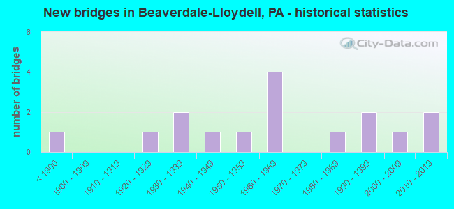
- New bridges - historical statistics
- 1Before 1900
- 11920-1929
- 21930-1939
- 11940-1949
- 11950-1959
- 41960-1969
- 11980-1989
- 21990-1999
- 12000-2009
- 22010-2019

- Reconstructed bridges - Historical Statistics
- 31980-1989
- 11990-1999
- 02000-2009
- 12010-2019


- Bridge Condition - Deck
- 13.3%Very good
- 46.7%Good
- 20.0%Satisfactory
- 13.3%Fair
- 6.7%Poor

- Bridge Condition - Superstructure
- 26.7%Very good
- 33.3%Good
- 13.3%Satisfactory
- 20.0%Fair
- 6.7%Poor

- Bridge Condition - Substructure
- 6.7%Very good
- 33.3%Good
- 20.0%Satisfactory
- 13.3%Fair
- 26.7%Poor

- Bridge Condition - Channel
- 42.9%Good
- 21.4%Satisfactory
- 21.4%Fair
- 14.3%Poor
Find on map >> Show street view
Structure Number: 7741, Location: 300 FT EAST OF SR 32 (Lat: 40.421797, Lng: -75.064597), Route carried "on" structure: ServiceState lands road , Year Built: 1832, Year Reconstructed: 1996, Status: Open, Structure Length: 1.80m (5.91ft), Average Daily Traffic: 20 (year 2012), Average Future Daily Traffic: 25 (year 2032), Features Intersected: DELAWARE CANAL, Facility Carried by Structure: PT PLEASANT BRIDGE
Minimum Vertical Clearance: 30+ m (98+ ft), Kilometerpoint: 0.000, Lanes on structure: 1, Owner: State Park, Forest, or Reservation Agency, Approaching Roadway Width: 3.0m (9.8ft), Material/Design: Prestressed concrete, Design/Construction: Box Beam or Girders - Multiple, Number Of Spans In Main Unit: 1, Length of Maximum Span: 17.1m (56.1ft), Curb or Sidewalk Widths: Left: 0.2m (0.7ft), Right: 0.2m (0.7ft), Curb-To-Curb Width: 3.3m (10.8ft), Out-to-Out Width: 3.7m (12.1ft)
Condition: Deck: Good, Superstructure: Good, Substructure: Poor, Channel: Good, Operating Rating: 62.6 metric tons, Method Used To Determine Operating Rating: Load Factor (LF), Inventory Rating: 37.2 metric tons, Method Used To Determine Inventory Rating: Load Factor (LF), Structural Evaluation: Meets minimum limits, Deck Geometry: High priority of replacement, Waterway Adequacy: Superior to present desirable criteria, Approach Roadway Alignment: Equal to present desirable criteria, Length Of Structure Improvement: 2.50m (8.20ft), Designated Inspection Frequency: Every 24 months, Inspection Date: April 2020, Bridge Improvement Cost: $5,000, Roadway Improvement Cost: $14,000, Total Project Cost: $100,000, Deck Structure Type: Other, Wearing Surface/Protective System: Wearing Surface: Bituminous
Find on map >> Show street view
Structure Number: 841, Location: OVER T-693 AT SR 8020 (Lat: 40.313011, Lng: -78.888372), Route carried "on" structure: State highway 56, Year Built: 1964, Year Reconstructed: 1994, Status: Open, Structure Length: 1.31m (4.30ft), Average Daily Traffic: 16,916 (year 2022), Truck Traffic: 6%, Average Future Daily Traffic: 27,573 (year 2032), Design Load: H 20, Features Intersected: WIDMAN STREET (T693)
Minimum Vertical Clearance: 30+ m (98+ ft), Kilometerpoint: 13.673, Lanes on structure: 4, Lanes under structure: 2, Base Highway Network: Yes, Owner: State Highway Agency, Approaching Roadway Width: 21.3m (69.9ft), Skew: 30 degrees, Material/Design: Prestressed concrete, Design/Construction: Box Beam or Girders - Single/Spread, Number Of Spans In Main Unit: 1, Length of Maximum Span: 12.8m (42.0ft), Curb or Sidewalk Widths: Left: 0.2m (0.7ft), Right: 0.2m (0.7ft), Curb-To-Curb Width: 20.7m (67.9ft), Out-to-Out Width: 22.4m (73.5ft)
Condition: Deck: Good, Superstructure: Good, Substructure: Good, Operating Rating: 89.8 metric tons, Method Used To Determine Operating Rating: Load Factor (LF), Inventory Rating: 40.8 metric tons, Method Used To Determine Inventory Rating: Load Factor (LF), Structural Evaluation: Better than present minimum criteria, Deck Geometry: Equal to present minimum criteria, Underclear: Meets minimum limits, Approach Roadway Alignment: Equal to present desirable criteria, Length Of Structure Improvement: 2.00m (6.56ft), Designated Inspection Frequency: Every 48 months, Inspection Date: Febuary 2019, Deck Structure Type: Concrete Cast-file-Place, Wearing Surface/Protective System: Wearing Surface: Monolithic Concrete, Deck Protection: Epoxy Coated Reinforcing
Find on map >> Show street view
Structure Number: 8675, Location: TWIN ROCKS (Lat: 40.490319, Lng: -78.862639), Route carried "on" structure: State highway , Year Built: 1954, Status: Open, Structure Length: 2.29m (7.51ft), Average Daily Traffic: 770 (year 2020), Truck Traffic: 2%, Average Future Daily Traffic: 673 (year 2032), Design Load: HS 20, Features Intersected: S.BR.BLACKLICK CREEK, Facility Carried by Structure: SR 3047
Minimum Vertical Clearance: 30+ m (98+ ft), Kilometerpoint: 4.241, Lanes on structure: 2, Owner: State Highway Agency, Approaching Roadway Width: 6.7m (22.0ft), Material/Design: Steel, Design/Construction: Stringer/Multi-beam, Number Of Spans In Main Unit: 1, Length of Maximum Span: 21.6m (70.9ft), Curb or Sidewalk Widths: Left: 0.1m (0.3ft), Right: 0.1m (0.3ft), Curb-To-Curb Width: 9.1m (29.9ft), Out-to-Out Width: 9.9m (32.5ft)
Condition: Deck: Satisfactory, Superstructure: Good, Substructure: Satisfactory, Channel: Good, Operating Rating: 64.4 metric tons, Method Used To Determine Operating Rating: Load Factor (LF), Inventory Rating: 38.1 metric tons, Method Used To Determine Inventory Rating: Load Factor (LF), Structural Evaluation: Equal to present minimum criteria, Deck Geometry: Equal to present minimum criteria, Waterway Adequacy: Equal to present minimum criteria, Approach Roadway Alignment: Equal to present desirable criteria, Length Of Structure Improvement: 2.80m (9.19ft), Designated Inspection Frequency: Every 48 months, Inspection Date: September 2018, Bridge Improvement Cost: $254,000, Roadway Improvement Cost: $747,000, Total Project Cost: $3,424,000, Deck Structure Type: Closed Grating, Wearing Surface/Protective System: Wearing Surface: Bituminous
Find on map >> Show street view
Structure Number: 8761, Location: BEAVERDALE,NORTHEAST (Lat: 40.322600, Lng: -78.694864), Route carried "on" structure: City street , Year Built: 2007, Status: Open, Structure Length: 1.52m (4.99ft), Average Daily Traffic: 86 (year 2019), Average Future Daily Traffic: 118 (year 2039), Design Load: HL 93, Features Intersected: BEAVERDAM RUN, Facility Carried by Structure: T346,HOWARD AVE.
Minimum Vertical Clearance: 30+ m (98+ ft), Kilometerpoint: 0.000, Lanes on structure: 2, Owner: Town or Township Highway Agency, Approaching Roadway Width: 7.3m (24.0ft), Skew: 4 degrees, Material/Design: Prestressed concrete, Design/Construction: Box Beam or Girders - Single/Spread, Number Of Spans In Main Unit: 1, Length of Maximum Span: 14.6m (47.9ft), Curb or Sidewalk Widths: Left: 0.1m (0.3ft), Right: 0.1m (0.3ft), Curb-To-Curb Width: 7.3m (24.0ft), Out-to-Out Width: 8.4m (27.6ft)
Condition: Deck: Good, Superstructure: Very good, Substructure: Good, Channel: Good, Operating Rating: 58.1 metric tons, Method Used To Determine Operating Rating: Load and Resistance Factor (LRFR), Inventory Rating: 44.5 metric tons, Method Used To Determine Inventory Rating: Load and Resistance Factor (LRFR), Structural Evaluation: Better than present minimum criteria, Deck Geometry: Equal to present minimum criteria, Waterway Adequacy: Superior to present desirable criteria, Approach Roadway Alignment: Equal to present desirable criteria, Length Of Structure Improvement: 1.30m (4.27ft), Designated Inspection Frequency: Every 24 months, Inspection Date: December 2019, Bridge Improvement Cost: $48,000, Roadway Improvement Cost: $264,000, Total Project Cost: $651,000, Deck Structure Type: Concrete Cast-file-Place, Wearing Surface/Protective System: Wearing Surface: Monolithic Concrete, Deck Protection: Epoxy Coated Reinforcing
Find on map >> Show street view
Structure Number: 10047, Location: .1MI.WEST TR 841 37K04 (Lat: 39.914956, Lng: -75.815933), Route carried "on" structure: State highway 82, Year Built: 1932, Status: Open, Structure Length: 1.77m (5.81ft), Average Daily Traffic: 5,156 (year 2022), Truck Traffic: 13%, Average Future Daily Traffic: 5,975 (year 2032), Design Load: H 15, Features Intersected: DOE RUN, Facility Carried by Structure: DOE RUN ROAD
Minimum Vertical Clearance: 30+ m (98+ ft), Kilometerpoint: 11.084, Lanes on structure: 2, Base Highway Network: Yes, Owner: State Highway Agency, Approaching Roadway Width: 7.9m (25.9ft), Material/Design: Steel, Design/Construction: Stringer/Multi-beam, Number Of Spans In Main Unit: 1, Length of Maximum Span: 16.8m (55.1ft), Curb-To-Curb Width: 6.7m (22.0ft), Out-to-Out Width: 7.0m (23.0ft)
Condition: Deck: Poor, Superstructure: Poor, Substructure: Poor, Channel: Fair, Operating Rating: 43.5 metric tons, Method Used To Determine Operating Rating: Load Factor (LF), Inventory Rating: 25.4 metric tons, Method Used To Determine Inventory Rating: Load Factor (LF), Structural Evaluation: Meets minimum limits, Deck Geometry: High priority of replacement, Waterway Adequacy: Somewhat better than minimum adequacy, Approach Roadway Alignment: Equal to present desirable criteria, Length Of Structure Improvement: 2.40m (7.87ft), Designated Inspection Frequency: Every 24 months, Other Special Inspection Frequency: Every 12 months, Inspection Date: May 2020, Other Special Inspection Date: May 2021, Bridge Improvement Cost: $9,000, Roadway Improvement Cost: $26,000, Total Project Cost: $119,000, Deck Structure Type: Open Grating
Find on map >> Show street view
Structure Number: 125, Location: 0.5 MILE W OF LIGHTSTREET (Lat: 41.026472, Lng: -76.442689), Route carried "on" structure: Interstate 80, Year Built: 1963, Year Reconstructed: 1992, Status: Open, Structure Length: 6.55m (21.49ft), Average Daily Traffic: 18,191 (year 2021), Truck Traffic: 33%, Average Future Daily Traffic: 30,400 (year 2032), Design Load: HS 20+Mod, Features Intersected: OVER TWP RD T-488
Minimum Vertical Clearance: 30+ m (98+ ft), Kilometerpoint: 10.282, Lanes on structure: 2, Lanes under structure: 2, Base Highway Network: Yes, Owner: State Highway Agency, Approaching Roadway Width: 10.4m (34.1ft), Skew: 14 degrees, Material/Design: Prestressed concrete continuous, Design/Construction: Box Beam or Girders - Single/Spread, Number Of Spans In Main Unit: 4, Length of Maximum Span: 19.5m (64.0ft), Curb or Sidewalk Widths: Left: 0.2m (0.7ft), Right: 0.2m (0.7ft), Curb-To-Curb Width: 10.4m (34.1ft), Out-to-Out Width: 11.4m (37.4ft)
Condition: Deck: Good, Superstructure: Satisfactory, Substructure: Satisfactory, Operating Rating: 68.9 metric tons, Method Used To Determine Operating Rating: Load Factor (LF), Inventory Rating: 37.2 metric tons, Method Used To Determine Inventory Rating: Load Factor (LF), Structural Evaluation: Equal to present minimum criteria, Deck Geometry: Meets minimum limits, Underclear: Equal to present minimum criteria, Approach Roadway Alignment: Equal to present desirable criteria, Length Of Structure Improvement: 6.60m (21.65ft), Designated Inspection Frequency: Every 24 months, Inspection Date: Febuary 2021, Deck Structure Type: Concrete Cast-file-Place, Wearing Surface/Protective System: Wearing Surface: Epoxy Overlay, Deck Protection: Epoxy Coated Reinforcing
Find on map >> Show street view
Structure Number: 13332, Location: BEAVER TOWNSHIP (Lat: 41.789583, Lng: -80.467956), Route carried "on" structure: State highway , Year Built: 1961, Status: Open, Structure Length: 0.70m (2.30ft), Average Daily Traffic: 401 (year 2021), Truck Traffic: 9%, Average Future Daily Traffic: 647 (year 2032), Design Load: HS 20, Features Intersected: OVER CONNEAUT CREEK W BR, Facility Carried by Structure: SR 4001,BEAVER CNT
Minimum Vertical Clearance: 30+ m (98+ ft), Kilometerpoint: 11.283, Lanes on structure: 2, Owner: State Highway Agency, Approaching Roadway Width: 5.5m (18.0ft), Material/Design: Concrete, Design/Construction: Slab, Number Of Spans In Main Unit: 1, Length of Maximum Span: 6.7m (22.0ft), Curb or Sidewalk Widths: Left: 0.5m (1.6ft), Right: 0.5m (1.6ft), Curb-To-Curb Width: 9.1m (29.9ft), Out-to-Out Width: 10.8m (35.4ft)
Condition: Deck: Good, Superstructure: Good, Substructure: Fair, Channel: Fair, Operating Rating: 52.6 metric tons, Method Used To Determine Operating Rating: Field evaluation and documented engineering judgment, Inventory Rating: 30.8 metric tons, Method Used To Determine Inventory Rating: Field evaluation and documented engineering judgment, Structural Evaluation: Somewhat better than minimum adequacy, Deck Geometry: Equal to present minimum criteria, Waterway Adequacy: Better than present minimum criteria, Approach Roadway Alignment: Equal to present desirable criteria, Length Of Structure Improvement: 1.30m (4.27ft), Designated Inspection Frequency: Every 24 months, Inspection Date: Febuary 2020, Wearing Surface/Protective System: Wearing Surface: Bituminous
Find on map >> Show street view
Structure Number: 13396, Location: 2 MI. NW. TYRONVILLE (Lat: 41.714344, Lng: -79.828292), Route carried "on" structure: City street 7201, Year Built: 1960, Status: Posted for load, Structure Length: 0.82m (2.69ft), Average Daily Traffic: 50 (year 2020), Truck Traffic: 1%, Average Future Daily Traffic: 63 (year 2040), Design Load: H 20, Features Intersected: OVER E.BR.MUDDY CREEK, Facility Carried by Structure: T-828,OLD GRADE RD
Minimum Vertical Clearance: 30+ m (98+ ft), Kilometerpoint: 0.000, Lanes on structure: 1, Owner: Town or Township Highway Agency, Approaching Roadway Width: 3.7m (12.1ft), Material/Design: Steel, Design/Construction: Stringer/Multi-beam, Number Of Spans In Main Unit: 1, Length of Maximum Span: 7.6m (24.9ft), Curb-To-Curb Width: 4.2m (13.8ft), Out-to-Out Width: 4.3m (14.1ft)
Condition: Deck: Fair, Superstructure: Fair, Substructure: Poor, Channel: Poor, Operating Rating: 44.5 metric tons, Method Used To Determine Operating Rating: Load Factor (LF), Inventory Rating: 26.3 metric tons, Method Used To Determine Inventory Rating: Load Factor (LF), Structural Evaluation: Meets minimum limits, Deck Geometry: Somewhat better than minimum adequacy, Waterway Adequacy: Better than present minimum criteria, Approach Roadway Alignment: Better than present minimum criteria, Bridge Posting: Required (Relationship of Operating Rating to Maximum Legal Load: 0.1 - 9.9% below), Length Of Structure Improvement: 1.00m (3.28ft), Designated Inspection Frequency: Every 24 months, Other Special Inspection Frequency: Every 12 months, Inspection Date: July 2020, Other Special Inspection Date: July 2021, Bridge Improvement Cost: $35,000, Roadway Improvement Cost: $233,000, Total Project Cost: $468,000, Deck Structure Type: Concrete Cast-file-Place, Wearing Surface/Protective System: Wearing Surface: Monolithic Concrete
Find on map >> Show street view
Structure Number: 13401, Location: 3 MI. N.W. BEAVER CENTER (Lat: 41.827536, Lng: -80.491556), Route carried "on" structure: City street 7202, Year Built: 1920, Year Reconstructed: 1988, Status: Open, Structure Length: 0.85m (2.79ft), Average Daily Traffic: 250 (year 2020), Truck Traffic: 1%, Average Future Daily Traffic: 350 (year 2040), Design Load: HS 20, Features Intersected: OVER MIDDLE BR.CONNEAUT, Facility Carried by Structure: T-867,PHILADELPHIA
Minimum Vertical Clearance: 30+ m (98+ ft), Kilometerpoint: 0.000, Lanes on structure: 2, Owner: Town or Township Highway Agency, Approaching Roadway Width: 4.0m (13.1ft), Material/Design: Steel, Design/Construction: Stringer/Multi-beam, Number Of Spans In Main Unit: 1, Length of Maximum Span: 8.2m (26.9ft), Curb-To-Curb Width: 4.9m (16.1ft), Out-to-Out Width: 5.5m (18.0ft)
Condition: Deck: Satisfactory, Superstructure: Fair, Substructure: Satisfactory, Channel: Fair, Operating Rating: 65.3 metric tons, Method Used To Determine Operating Rating: Load Factor (LF), Inventory Rating: 39.0 metric tons, Method Used To Determine Inventory Rating: Load Factor (LF), Structural Evaluation: Somewhat better than minimum adequacy, Deck Geometry: High priority of replacement, Waterway Adequacy: Equal to present desirable criteria, Approach Roadway Alignment: Equal to present desirable criteria, Length Of Structure Improvement: 1.10m (3.61ft), Designated Inspection Frequency: Every 24 months, Inspection Date: Febuary 2020, Deck Structure Type: Corrugated Steel
Find on map >> Show street view
Structure Number: 13402, Location: BEAVER TOWNSHIP (Lat: 41.826475, Lng: -80.426561), Route carried "on" structure: City street 7202, Year Built: 1991, Status: Open, Structure Length: 1.07m (3.51ft), Average Daily Traffic: 250 (year 2020), Truck Traffic: 1%, Average Future Daily Traffic: 350 (year 2040), Design Load: HS 25 or greater, Features Intersected: OVER STONE RUN, Facility Carried by Structure: T-867,PHILADELPHIA
Minimum Vertical Clearance: 30+ m (98+ ft), Kilometerpoint: 0.000, Lanes on structure: 2, Owner: Town or Township Highway Agency, Approaching Roadway Width: 4.9m (16.1ft), Material/Design: Steel, Design/Construction: Stringer/Multi-beam, Number Of Spans In Main Unit: 1, Length of Maximum Span: 9.1m (29.9ft), Curb-To-Curb Width: 5.3m (17.4ft), Out-to-Out Width: 5.8m (19.0ft)
Condition: Deck: Fair, Superstructure: Satisfactory, Substructure: Poor, Channel: Poor, Inventory Rating: 87.1 metric tons, Method Used To Determine Inventory Rating: Load Factor (LF), Structural Evaluation: Meets minimum limits, Deck Geometry: High priority of replacement, Waterway Adequacy: Better than present minimum criteria, Approach Roadway Alignment: Better than present minimum criteria, Length Of Structure Improvement: 1.30m (4.27ft), Designated Inspection Frequency: Every 24 months, Inspection Date: Febuary 2020, Bridge Improvement Cost: $40,000, Roadway Improvement Cost: $264,000, Total Project Cost: $543,000, Deck Structure Type: Corrugated Steel
Find on map >> Show street view
Structure Number: 16001, Location: VENANGO TOWNSHIP (Lat: 42.024794, Lng: -79.818250), Route carried "on" structure: State highway 89, Year Built: 1990, Status: Open, Structure Length: 2.68m (8.79ft), Average Daily Traffic: 1,889 (year 2020), Truck Traffic: 12%, Average Future Daily Traffic: 2,367 (year 2032), Design Load: HS 25 or greater, Features Intersected: OVER FRENCH CREEK W BR
Minimum Vertical Clearance: 30+ m (98+ ft), Kilometerpoint: 19.669, Lanes on structure: 2, Base Highway Network: Yes, Owner: State Highway Agency, Approaching Roadway Width: 9.1m (29.9ft), Skew: 1 degrees, Material/Design: Prestressed concrete, Design/Construction: Box Beam or Girders - Multiple, Number Of Spans In Main Unit: 1, Length of Maximum Span: 26.2m (86.0ft), Curb or Sidewalk Widths: Left: 0.2m (0.7ft), Right: 0.2m (0.7ft), Curb-To-Curb Width: 13.8m (45.3ft), Out-to-Out Width: 14.8m (48.6ft)
Condition: Deck: Good, Superstructure: Good, Substructure: Good, Channel: Good, Inventory Rating: 31.8 metric tons, Method Used To Determine Inventory Rating: Load Factor (LF), Structural Evaluation: Better than present minimum criteria, Deck Geometry: Superior to present desirable criteria, Waterway Adequacy: Equal to present minimum criteria, Approach Roadway Alignment: Equal to present desirable criteria, Length Of Structure Improvement: 2.70m (8.86ft), Designated Inspection Frequency: Every 24 months, Underwater Inspection Frequency: Every 60 months, Inspection Date: August 2020, Underwater Inspection Date: June 2021, Deck Structure Type: Concrete Cast-file-Place, Wearing Surface/Protective System: Wearing Surface: Bituminous, Membrane: Preformed Fabric, Deck Protection: Epoxy Coated Reinforcing
Find on map >> Show street view
Structure Number: 16005, Location: GREENFIELD TOWNSHIP (Lat: 42.102506, Lng: -79.821794), Route carried "on" structure: State highway 89, Year Built: 1983, Status: Open, Structure Length: 2.53m (8.30ft), Average Daily Traffic: 1,889 (year 2020), Truck Traffic: 12%, Average Future Daily Traffic: 2,367 (year 2032), Design Load: HS 20, Features Intersected: OVER FRENCH CREEK W BR
Minimum Vertical Clearance: 30+ m (98+ ft), Kilometerpoint: 27.718, Lanes on structure: 2, Base Highway Network: Yes, Owner: State Highway Agency, Approaching Roadway Width: 8.5m (27.9ft), Material/Design: Prestressed concrete, Design/Construction: Box Beam or Girders - Multiple, Number Of Spans In Main Unit: 1, Length of Maximum Span: 24.7m (81.0ft), Curb or Sidewalk Widths: Left: 0.2m (0.7ft), Right: 0.2m (0.7ft), Curb-To-Curb Width: 10.1m (33.1ft), Out-to-Out Width: 11.1m (36.4ft)
Condition: Deck: Good, Superstructure: Very good, Substructure: Good, Channel: Satisfactory, Inventory Rating: 37.2 metric tons, Method Used To Determine Inventory Rating: Load Factor (LF), Structural Evaluation: Better than present minimum criteria, Deck Geometry: Somewhat better than minimum adequacy, Waterway Adequacy: Superior to present desirable criteria, Approach Roadway Alignment: Equal to present desirable criteria, Length Of Structure Improvement: 3.30m (10.83ft), Designated Inspection Frequency: Every 48 months, Inspection Date: April 2019, Deck Structure Type: Concrete Cast-file-Place, Wearing Surface/Protective System: Wearing Surface: Bituminous, Membrane: Preformed Fabric, Deck Protection: Epoxy Coated Reinforcing
Find on map >> Show street view
Structure Number: 16006, Location: GREENFIELD TOWNSHIP (Lat: 42.111967, Lng: -79.824031), Route carried "on" structure: State highway 89, Year Built: 1940, Status: Open, Structure Length: 0.73m (2.40ft), Average Daily Traffic: 1,889 (year 2020), Truck Traffic: 12%, Average Future Daily Traffic: 2,367 (year 2032), Design Load: H 20, Features Intersected: OVER FRENCH CREEK BRANCH
Minimum Vertical Clearance: 30+ m (98+ ft), Kilometerpoint: 29.488, Lanes on structure: 2, Base Highway Network: Yes, Owner: State Highway Agency, Approaching Roadway Width: 6.7m (22.0ft), Skew: 4 degrees, Material/Design: Concrete, Design/Construction: Tee Beam, Number Of Spans In Main Unit: 1, Length of Maximum Span: 6.7m (22.0ft), Curb-To-Curb Width: 9.3m (30.5ft), Out-to-Out Width: 10.4m (34.1ft)
Condition: Deck: Satisfactory, Superstructure: Fair, Substructure: Fair, Channel: Satisfactory, Operating Rating: 45.4 metric tons, Method Used To Determine Operating Rating: Load Factor (LF), Inventory Rating: 27.2 metric tons, Method Used To Determine Inventory Rating: Load Factor (LF), Structural Evaluation: Somewhat better than minimum adequacy, Deck Geometry: Somewhat better than minimum adequacy, Waterway Adequacy: Equal to present minimum criteria, Approach Roadway Alignment: Equal to present desirable criteria, Length Of Structure Improvement: 0.70m (2.30ft), Designated Inspection Frequency: Every 24 months, Inspection Date: May 2021, Bridge Improvement Cost: $5,000, Roadway Improvement Cost: $25,000, Total Project Cost: $63,000, Wearing Surface/Protective System: Wearing Surface: Bituminous
Find on map >> Show street view
Structure Number: 16012, Location: NORTH EAST TOWNSHIP (Lat: 42.235861, Lng: -79.833583), Route carried "on" structure: State highway 89, Year Built: 1930, Year Reconstructed: 2015, Status: Open, Structure Length: 0.94m (3.08ft), Average Daily Traffic: 2,126 (year 2022), Truck Traffic: 4%, Average Future Daily Traffic: 2,696 (year 2032), Design Load: HL 93, Features Intersected: OVER SIXTEEN MILE CREEK
Minimum Vertical Clearance: 30+ m (98+ ft), Kilometerpoint: 42.986, Lanes on structure: 2, Owner: State Highway Agency, Approaching Roadway Width: 9.4m (30.8ft), Material/Design: Prestressed concrete, Design/Construction: Box Beam or Girders - Single/Spread, Number Of Spans In Main Unit: 1, Length of Maximum Span: 9.1m (29.9ft), Curb or Sidewalk Widths: Left: 0.2m (0.7ft), Right: 0.2m (0.7ft), Curb-To-Curb Width: 12.0m (39.4ft), Out-to-Out Width: 13.1m (43.0ft)
Condition: Deck: Very good, Superstructure: Very good, Substructure: Good, Channel: Satisfactory, Operating Rating: 42.1 metric tons, Method Used To Determine Operating Rating: Assigned ratings based on Load and Resistance Factor Design (LRFD) reported by rating factor (RF) using HL93 loadings, Inventory Rating: 32.4 metric tons, Method Used To Determine Inventory Rating: Assigned ratings based on Load and Resistance Factor Design (LRFD) reported by rating factor (RF) using HL93 loadings, Structural Evaluation: Better than present minimum criteria, Deck Geometry: Somewhat better than minimum adequacy, Waterway Adequacy: Equal to present desirable criteria, Approach Roadway Alignment: Equal to present desirable criteria, Length Of Structure Improvement: 1.00m (3.28ft), Designated Inspection Frequency: Every 48 months, Inspection Date: May 2020, Bridge Improvement Cost: $13,000, Roadway Improvement Cost: $37,000, Total Project Cost: $172,000, Wearing Surface/Protective System: Wearing Surface: Epoxy Overlay, Deck Protection: Epoxy Coated Reinforcing
Find on map >> Show street view
Structure Number: 46807, Location: 0.04 MILE NORTH FROM PA 8 (Lat: 40.321783, Lng: -78.696833), Route carried "on" structure: State highway , Year Built: 2011, Status: Open, Structure Length: 2.23m (7.32ft), Average Daily Traffic: 739 (year 2020), Truck Traffic: 4%, Average Future Daily Traffic: 1,017 (year 2032), Design Load: HL 93, Features Intersected: S FORK L CONEMAUGH RIV, Facility Carried by Structure: SR 2007
Minimum Vertical Clearance: 30+ m (98+ ft), Kilometerpoint: 0.000, Lanes on structure: 2, Owner: State Highway Agency, Approaching Roadway Width: 10.1m (33.1ft), Material/Design: Prestressed concrete, Design/Construction: Box Beam or Girders - Single/Spread, Number Of Spans In Main Unit: 1, Length of Maximum Span: 21.9m (71.9ft), Curb or Sidewalk Widths: Left: 0.2m (0.7ft), Right: 0.2m (0.7ft), Curb-To-Curb Width: 10.6m (34.8ft), Out-to-Out Width: 11.7m (38.4ft)
Condition: Deck: Very good, Superstructure: Very good, Substructure: Very good, Channel: Good, Operating Rating: 61.6 metric tons, Method Used To Determine Operating Rating: Assigned ratings based on Load and Resistance Factor Design (LRFD) reported by rating factor (RF) using HL93 loadings, Inventory Rating: 34.0 metric tons, Method Used To Determine Inventory Rating: Assigned ratings based on Load and Resistance Factor Design (LRFD) reported by rating factor (RF) using HL93 loadings, Structural Evaluation: Equal to present desirable criteria, Deck Geometry: Equal to present minimum criteria, Waterway Adequacy: Superior to present desirable criteria, Approach Roadway Alignment: Equal to present desirable criteria, Designated Inspection Frequency: Every 48 months, Inspection Date: September 2019, Deck Structure Type: Concrete Cast-file-Place, Wearing Surface/Protective System: Wearing Surface: Monolithic Concrete, Deck Protection: Epoxy Coated Reinforcing
Find on map >> Show street view
Structure Number: 57058, Location: 1 MI E OF BEAVERDALE (Lat: 40.337194, Lng: -78.701511), Route carried "on" structure: State highway , Year Built: 2019, Status: Open, Structure Length: 0.79m (2.59ft), Average Daily Traffic: 739 (year 2020), Truck Traffic: 4%, Average Future Daily Traffic: 900 (year 2029), Design Load: HL 93, Features Intersected: LAUREL RUN, Facility Carried by Structure: SR 2007
Minimum Vertical Clearance: 30+ m (98+ ft), Kilometerpoint: 2.111, Lanes on structure: 2, Owner: State Highway Agency, Approaching Roadway Width: 8.8m (28.9ft), Material/Design: Concrete, Design/Construction: Culvert, Number Of Spans In Main Unit: 1, Length of Maximum Span: 7.3m (24.0ft)
Condition: Channel: Good, Culverts: Very good, Operating Rating: 56.4 metric tons, Method Used To Determine Operating Rating: Assigned ratings based on Load and Resistance Factor Design (LRFD) reported by rating factor (RF) using HL93 loadings, Inventory Rating: 36.3 metric tons, Method Used To Determine Inventory Rating: Assigned ratings based on Load and Resistance Factor Design (LRFD) reported by rating factor (RF) using HL93 loadings, Structural Evaluation: Equal to present desirable criteria, Waterway Adequacy: Equal to present minimum criteria, Approach Roadway Alignment: Equal to present desirable criteria, Length Of Structure Improvement: 0.80m (2.62ft), Designated Inspection Frequency: Every 24 months, Inspection Date: April 2021