Bridge Statistics for Beaver, Pennsylvania (PA)
Condition, Traffic, Stress, Structural Evaluation, Project Costs
- National Bridge Inventory (NBI) Statistics
- 22Number of bridges
- 174ft / 52.9mTotal length
- $1,530,000Total costs
- 170,906Total average daily traffic
- 16,386Total average daily truck traffic
- National Bridge Inventory (NBI) Registered Bridges for Beaver
- No street view available for this location
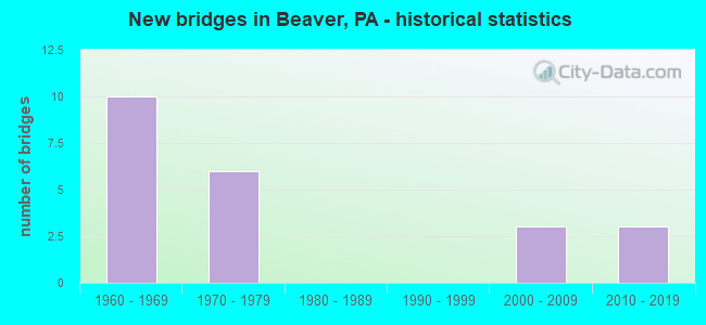
- New bridges - historical statistics
- 101960-1969
- 61970-1979
- 32000-2009
- 32010-2019

- Reconstructed bridges - Historical Statistics
- 11990-1999
- 12000-2009
- 12010-2019


- Bridge Condition - Deck
- 42.9%Good
- 14.3%Satisfactory
- 28.6%Fair
- 14.3%Poor

- Bridge Condition - Superstructure
- 28.6%Good
- 71.4%Fair

- Bridge Condition - Substructure
- 42.9%Good
- 28.6%Satisfactory
- 28.6%Fair

- Bridge Condition - Channel
- 33.3%Good
- 66.7%Satisfactory
Find on map >> Show street view
Structure Number: 3487, Location: BEAVER-ROCHESTER BRIDGE (Lat: 40.701356, Lng: -80.291292), Route carried "on" structure: State highway 51, Year Built: 1963, Year Reconstructed: 2011, Status: Open, Structure Length: 30.27m (99.31ft), Average Daily Traffic: 23,785 (year 2021), Truck Traffic: 6%, Average Future Daily Traffic: 26,775 (year 2033), Design Load: HS 20, Features Intersected: SR 65, BEAVER R, N-S RR, Facility Carried by Structure: BEAVER-ROCHESTE
Minimum Vertical Clearance: 30+ m (98+ ft), Kilometerpoint: 16.472, Lanes on structure: 4, Lanes under structure: 23, Base Highway Network: Yes, Owner: State Highway Agency, Approaching Roadway Width: 18.3m (60.0ft), Skew: 30 degrees, Material/Design: Steel continuous, Design/Construction: Truss - Deck, Number Of Spans In Main Unit: 3, Number Of Approach Spans: 5, Length of Maximum Span: 111.3m (365.2ft), Curb or Sidewalk Widths: Left: 0.2m (0.7ft), Right: 0.2m (0.7ft), Curb-To-Curb Width: 18.3m (60.0ft), Out-to-Out Width: 20.3m (66.6ft)
Condition: Deck: Satisfactory, Superstructure: Fair, Substructure: Satisfactory, Channel: Good, Operating Rating: 55.3 metric tons, Method Used To Determine Operating Rating: Load Factor (LF), Inventory Rating: 33.6 metric tons, Method Used To Determine Inventory Rating: Load Factor (LF), Structural Evaluation: Somewhat better than minimum adequacy, Deck Geometry: Somewhat better than minimum adequacy, Underclear: High priority of corrective action, Waterway Adequacy: Superior to present desirable criteria, Approach Roadway Alignment: Equal to present minimum criteria, Designated Inspection Frequency: Every 24 months, Critical Feature Inspection Frequency: Every 24 months, Underwater Inspection Frequency: Every 60 months, Other Special Inspection Frequency: Every 6 months, Inspection Date: August 2021, Critical Feature Inspection Date: August 2021, Underwater Inspection Date: August 2020, Other Special Inspection Date: August 2021, Deck Structure Type: Concrete Cast-file-Place, Wearing Surface/Protective System: Wearing Surface: Monolithic Concrete, Deck Protection: Epoxy Coated Reinforcing
Find on map >> Show street view
Structure Number: 3528, Location: 0.4 MI NE OF SR 0068 (Lat: 40.685069, Lng: -80.335478), Route carried "on" structure: Interstate 376, Year Built: 1969, Year Reconstructed: 2001, Status: Open, Structure Length: 5.43m (17.81ft), Average Daily Traffic: 18,756 (year 2020), Truck Traffic: 15%, Average Future Daily Traffic: 27,806 (year 2032), Design Load: HS 20, Features Intersected: TWP.RD.513, Facility Carried by Structure: BEAVER VALLEY EX
Minimum Vertical Clearance: 30+ m (98+ ft), Kilometerpoint: 10.800, Lanes on structure: 6, Lanes under structure: 2, Base Highway Network: Yes, Owner: State Highway Agency, Approaching Roadway Width: 32.3m (106.0ft), Skew: 39 degrees, Material/Design: Prestressed concrete, Design/Construction: Box Beam or Girders - Multiple, Number Of Spans In Main Unit: 1, Number Of Approach Spans: 4, Length of Maximum Span: 12.2m (40.0ft), Curb or Sidewalk Widths: Left: 0.2m (0.7ft), Right: 0.2m (0.7ft), Curb-To-Curb Width: 32.3m (106.0ft), Out-to-Out Width: 33.2m (108.9ft)
Condition: Deck: Fair, Superstructure: Fair, Substructure: Satisfactory, Operating Rating: 49.0 metric tons, Method Used To Determine Operating Rating: Load Factor (LF), Inventory Rating: 29.0 metric tons, Method Used To Determine Inventory Rating: Load Factor (LF), Structural Evaluation: Somewhat better than minimum adequacy, Deck Geometry: Superior to present desirable criteria, Underclear: Meets minimum limits, Approach Roadway Alignment: Equal to present desirable criteria, Length Of Structure Improvement: 5.50m (18.04ft), Designated Inspection Frequency: Every 24 months, Inspection Date: April 2021, Bridge Improvement Cost: $35,000, Roadway Improvement Cost: $104,000, Total Project Cost: $475,000, Deck Structure Type: Concrete Cast-file-Place, Wearing Surface/Protective System: Wearing Surface: Monolithic Concrete
Find on map >> Show street view
Structure Number: 3568, Location: SR 68 OVER I-376 (Lat: 40.682953, Lng: -80.333786), Route carried "on" structure: State highway 68, Year Built: 1967, Year Reconstructed: 2017, Status: Open, Structure Length: 2.93m (9.61ft), Average Daily Traffic: 13,012 (year 2022), Truck Traffic: 6%, Average Future Daily Traffic: 19,162 (year 2032), Design Load: HS 20, Features Intersected: SR 0376, Facility Carried by Structure: MIDLAND BEAVER RD
Minimum Vertical Clearance: 30+ m (98+ ft), Kilometerpoint: 18.495, Lanes on structure: 6, Lanes under structure: 10, Base Highway Network: Yes, Owner: State Highway Agency, Approaching Roadway Width: 24.4m (80.1ft), Skew: 20 degrees, Material/Design: Prestressed concrete, Design/Construction: Box Beam or Girders - Single/Spread, Number Of Spans In Main Unit: 1, Length of Maximum Span: 28.3m (92.8ft), Curb or Sidewalk Widths: Left: 0.5m (1.6ft), Right: 1.5m (4.9ft), Curb-To-Curb Width: 25.0m (82.0ft), Out-to-Out Width: 27.3m (89.6ft)
Condition: Deck: Good, Superstructure: Fair, Substructure: Good, Operating Rating: 92.5 metric tons, Method Used To Determine Operating Rating: Load Factor (LF), Inventory Rating: 13.6 metric tons, Method Used To Determine Inventory Rating: Load Factor (LF), Structural Evaluation: High priority of corrective action, Deck Geometry: Somewhat better than minimum adequacy, Underclear: High priority of corrective action, Approach Roadway Alignment: Equal to present desirable criteria, Length Of Structure Improvement: 2.80m (9.19ft), Designated Inspection Frequency: Every 24 months, Inspection Date: August 2020, Bridge Improvement Cost: $58,000, Roadway Improvement Cost: $172,000, Total Project Cost: $788,000, Deck Structure Type: Concrete Cast-file-Place, Wearing Surface/Protective System: Wearing Surface: Monolithic Concrete
Find on map >> Show street view
Structure Number: 44329, Location: 3017 Center exit over 376 (Lat: 40.636333, Lng: -80.320117), Route carried "on" structure: State highway , Year Built: 2007, Status: Open, Structure Length: 7.28m (23.88ft), Average Daily Traffic: 9,196 (year 2022), Truck Traffic: 4%, Average Future Daily Traffic: 380 (year 2032), Design Load: HL 93, Features Intersected: SR 0376 EB-WB, Facility Carried by Structure: Pleasantville Road
Minimum Vertical Clearance: 30+ m (98+ ft), Kilometerpoint: 0.484, Lanes on structure: 2, Lanes under structure: 4, Owner: State Highway Agency, Approaching Roadway Width: 22.9m (75.1ft), Skew: 23 degrees, Material/Design: Prestressed concrete, Design/Construction: Box Beam or Girders - Single/Spread, Number Of Spans In Main Unit: 4, Length of Maximum Span: 20.4m (66.9ft), Curb or Sidewalk Widths: Left: 0.2m (0.7ft), Right: 0.2m (0.7ft), Curb-To-Curb Width: 20.7m (67.9ft), Out-to-Out Width: 23.2m (76.1ft)
Condition: Deck: Good, Superstructure: Good, Substructure: Good, Operating Rating: 55.3 metric tons, Method Used To Determine Operating Rating: Load and Resistance Factor (LRFR), Inventory Rating: 42.6 metric tons, Method Used To Determine Inventory Rating: Load and Resistance Factor (LRFR), Structural Evaluation: Better than present minimum criteria, Deck Geometry: Superior to present desirable criteria, Underclear: High priority of corrective action, Approach Roadway Alignment: Equal to present desirable criteria, Designated Inspection Frequency: Every 24 months, Inspection Date: April 2021, Deck Structure Type: Concrete Cast-file-Place, Wearing Surface/Protective System: Wearing Surface: Monolithic Concrete, Deck Protection: Epoxy Coated Reinforcing
Find on map >> Show street view
Structure Number: 45379, Location: Inside park near park lot (Lat: 40.707278, Lng: -80.347272), Route carried "on" structure: City street , Year Built: 1976, Status: Posted for load, Structure Length: 0.91m (2.99ft), Average Daily Traffic: 10 (year 2019), Truck Traffic: 1%, Average Future Daily Traffic: 15 (year 2041), Design Load: HS 20, Features Intersected: Two Mile Run, Facility Carried by Structure: Park Access Road
Minimum Vertical Clearance: 30+ m (98+ ft), Kilometerpoint: 0.000, Lanes on structure: 1, Owner: Town or Township Highway Agency, Approaching Roadway Width: 3.0m (9.8ft), Skew: 1 degrees, Material/Design: Steel, Design/Construction: Girder and Floorbeam System, Number Of Spans In Main Unit: 1, Length of Maximum Span: 8.8m (28.9ft), Curb or Sidewalk Widths: Left: 0.3m (1.0ft), Right: 0.3m (1.0ft), Curb-To-Curb Width: 3.3m (10.8ft), Out-to-Out Width: 3.3m (10.8ft)
Condition: Deck: Poor, Superstructure: Fair, Substructure: Fair, Channel: Satisfactory, Operating Rating: 11.8 metric tons, Method Used To Determine Operating Rating: Allowable Stress (AS), Inventory Rating: 8.2 metric tons, Method Used To Determine Inventory Rating: Allowable Stress (AS), Structural Evaluation: High priority of corrective action, Deck Geometry: High priority of replacement, Waterway Adequacy: Better than present minimum criteria, Approach Roadway Alignment: Equal to present desirable criteria, Bridge Posting: Required (Relationship of Operating Rating to Maximum Legal Load: > 39.9% below), Length Of Structure Improvement: 0.90m (2.95ft), Designated Inspection Frequency: Every 24 months, Critical Feature Inspection Frequency: Every 12 months, Other Special Inspection Frequency: Every 12 months, Inspection Date: December 2019, Critical Feature Inspection Date: December 2020, Other Special Inspection Date: December 2020, Bridge Improvement Cost: $30,000, Roadway Improvement Cost: $32,000, Total Project Cost: $167,000, Deck Structure Type: Wood or Timber, Wearing Surface/Protective System: Wearing Surface: Wood or Timber
Find on map >> Show street view
Structure Number: 4538, Location: Inside Two Mile Run Pk (Lat: 40.706922, Lng: -80.348514), Route carried "on" structure: State lands road , Year Built: 1976, Status: Posted for load, Structure Length: 0.91m (2.99ft), Average Daily Traffic: 10 (year 2019), Truck Traffic: 1%, Average Future Daily Traffic: 15 (year 2041), Design Load: HS 20, Features Intersected: Two Mile Run, Facility Carried by Structure: Park Access Road
Minimum Vertical Clearance: 30+ m (98+ ft), Kilometerpoint: 0.000, Lanes on structure: 1, Owner: Town or Township Highway Agency, Approaching Roadway Width: 3.0m (9.8ft), Skew: 1 degrees, Material/Design: Steel, Design/Construction: Girder and Floorbeam System, Number Of Spans In Main Unit: 1, Length of Maximum Span: 8.5m (27.9ft), Curb or Sidewalk Widths: Left: 0.3m (1.0ft), Right: 0.3m (1.0ft), Curb-To-Curb Width: 3.4m (11.2ft), Out-to-Out Width: 3.4m (11.2ft)
Condition: Deck: Fair, Superstructure: Fair, Substructure: Fair, Channel: Satisfactory, Operating Rating: 11.8 metric tons, Method Used To Determine Operating Rating: Allowable Stress (AS), Inventory Rating: 8.2 metric tons, Method Used To Determine Inventory Rating: Allowable Stress (AS), Structural Evaluation: High priority of corrective action, Deck Geometry: High priority of corrective action, Waterway Adequacy: Better than present minimum criteria, Approach Roadway Alignment: Equal to present desirable criteria, Bridge Posting: Required (Relationship of Operating Rating to Maximum Legal Load: > 39.9% below), Length Of Structure Improvement: 0.90m (2.95ft), Designated Inspection Frequency: Every 24 months, Critical Feature Inspection Frequency: Every 12 months, Other Special Inspection Frequency: Every 12 months, Inspection Date: December 2019, Critical Feature Inspection Date: December 2020, Other Special Inspection Date: December 2020, Bridge Improvement Cost: $35,000, Roadway Improvement Cost: $15,000, Total Project Cost: $100,000, Deck Structure Type: Wood or Timber, Wearing Surface/Protective System: Wearing Surface: Wood or Timber
Find on map >> Show street view
Structure Number: 53259, Location: OS Bvr Vly Toll (Lat: 40.814536, Lng: -80.326014), Route carried "on" structure: Other road 76, Year Built: 2014, Status: Open, Structure Length: 5.21m (17.09ft), Average Daily Traffic: 5,000 (year 2016), Truck Traffic: 2%, Average Future Daily Traffic: 8,000 (year 2036), Design Load: HS 20, Features Intersected: LR 77- SR 0018
Minimum Vertical Clearance: 30+ m (98+ ft), Kilometerpoint: 20.535, Lanes on structure: 2, Lanes under structure: 5, Base Highway Network: Yes, Toll: On toll road, Owner: State Toll Authority, Approaching Roadway Width: 11.6m (38.1ft), Material/Design: Steel, Design/Construction: Truss - Thru, Number Of Spans In Main Unit: 1, Length of Maximum Span: 51.8m (169.9ft), Curb-To-Curb Width: 9.1m (29.9ft), Out-to-Out Width: 9.1m (29.9ft)
Condition: Deck: Good, Superstructure: Good, Substructure: Good, Operating Rating: 63.5 metric tons, Method Used To Determine Operating Rating: Load and Resistance Factor (LRFR), Inventory Rating: 49.0 metric tons, Method Used To Determine Inventory Rating: Load and Resistance Factor (LRFR), Structural Evaluation: Better than present minimum criteria, Deck Geometry: Meets minimum limits, Underclear: Meets minimum limits, Approach Roadway Alignment: Better than present minimum criteria, Designated Inspection Frequency: Every 24 months, Critical Feature Inspection Frequency: Every 6 months, Other Special Inspection Frequency: Every 6 months, Inspection Date: May 2020, Critical Feature Inspection Date: November 2020, Other Special Inspection Date: November 2020, Deck Structure Type: Closed Grating, Wearing Surface/Protective System: Wearing Surface: Epoxy Overlay, Deck Protection: Epoxy Coated Reinforcing
Find on map >> Show street view
Structure Number: 3487, Location: BEAVER-ROCHESTER BRIDGE (Lat: 40.701356, Lng: -80.291292), Route carried "under" structure: State highway 18, Year Built: 1963, Structure Length: 0. m, Average Daily Traffic: 8,918 (year 2020), Truck Traffic: 4%, Features Intersected: SR 65, BEAVER R, N-S RR, Facility Carried by Structure: BEAVER-ROCHESTE
Minimum Vertical Clearance: 4.83m (15.85ft), Kilometerpoint: 34.393, Lanes on structure: 4, Lanes under structure: 7, Material/Design: Steel continuous, Design/Construction: Truss - Deck, Length of Maximum Span: 111.3m (365.2ft)
Find on map >> Show street view
Structure Number: 3487, Location: BEAVER-ROCHESTER BRIDGE (Lat: 40.701356, Lng: -80.291292), Route carried "under" structure: State highway 18, Year Built: 1963, Structure Length: 0. m, Average Daily Traffic: 8,275 (year 2020), Truck Traffic: 4%, Features Intersected: SR 65, BEAVER R, N-S RR, Facility Carried by Structure: BEAVER-ROCHESTE
Minimum Vertical Clearance: 4.78m (15.68ft), Kilometerpoint: 34.393, Lanes on structure: 4, Lanes under structure: 7, Material/Design: Steel continuous, Design/Construction: Truss - Deck, Length of Maximum Span: 111.3m (365.2ft)
Find on map >> Show street view
Structure Number: 3487, Location: BEAVER-ROCHESTER BRIDGE (Lat: 40.701356, Lng: -80.291292), Route carried "under" structure: City street , Year Built: 1963, Structure Length: 0. m, Average Daily Traffic: 2,283 (year 2017), Truck Traffic: 1%, Features Intersected: SR 65, BEAVER R, N-S RR, Facility Carried by Structure: BEAVER-ROCHESTE
Minimum Vertical Clearance: 30+ m (98+ ft), Kilometerpoint: 0.000, Lanes on structure: 4, Lanes under structure: 2, Material/Design: Steel continuous, Design/Construction: Truss - Deck, Length of Maximum Span: 111.3m (365.2ft)
Find on map >> Show street view
Structure Number: 3487, Location: BEAVER-ROCHESTER BRIDGE (Lat: 40.701356, Lng: -80.291292), Route carried "under" structure: City street , Year Built: 1963, Structure Length: 0. m, Average Daily Traffic: 1 (year 2005), Truck Traffic: 1%, Features Intersected: SR 65, BEAVER R, N-S RR, Facility Carried by Structure: BEAVER-ROCHESTE
Minimum Vertical Clearance: 16.33m (53.58ft), Kilometerpoint: 0.000, Lanes on structure: 4, Lanes under structure: 7, Material/Design: Steel continuous, Design/Construction: Truss - Deck, Length of Maximum Span: 111.3m (365.2ft)
Find on map >> Show street view
Structure Number: 352, Location: INTERSECTION W SR 0018 (Lat: 40.668094, Lng: -80.325028), Route carried "under" structure: State highway 18, Year Built: 1970, Structure Length: 0. m, Average Daily Traffic: 9,723 (year 2022), Truck Traffic: 8%, Features Intersected: SR 0018 FRANKFORT RD, Facility Carried by Structure: SR 376 EB WB
Minimum Vertical Clearance: 5.17m (16.96ft), Kilometerpoint: 28.165, Lanes on structure: 6, Lanes under structure: 5, Material/Design: Prestressed concrete, Design/Construction: Box Beam or Girders - Single/Spread, Length of Maximum Span: 29.3m (96.1ft)
Find on map >> Show street view
Structure Number: 352, Location: INTERSECTION W SR 0018 (Lat: 40.668094, Lng: -80.325028), Route carried "under" structure: State highway 18, Year Built: 1970, Structure Length: 0. m, Average Daily Traffic: 10,014 (year 2022), Truck Traffic: 8%, Features Intersected: SR 0018 FRANKFORT RD, Facility Carried by Structure: SR 376 EB WB
Minimum Vertical Clearance: 5.16m (16.93ft), Kilometerpoint: 28.160, Lanes on structure: 6, Lanes under structure: 5, Material/Design: Prestressed concrete, Design/Construction: Box Beam or Girders - Single/Spread, Length of Maximum Span: 29.3m (96.1ft)
Find on map >> Show street view
Structure Number: 3521, Location: SHELL PLANT BRIDGE (Lat: 40.674164, Lng: -80.328592), Route carried "under" structure: ServiceOther road , Year Built: 1970, Structure Length: 0. m, Average Daily Traffic: 1 (year 2004), Truck Traffic: 1%, Features Intersected: CSX RR,PRIVATE ROAD, Facility Carried by Structure: I-376
Minimum Vertical Clearance: 6.33m (20.77ft), Kilometerpoint: 0.000, Lanes on structure: 4, Lanes under structure: 2, Material/Design: Prestressed concrete continuous, Design/Construction: Box Beam or Girders - Multiple, Length of Maximum Span: 25.3m (83.0ft)
Find on map >> Show street view
Structure Number: 3522, Location: Vanport Bridge (Lat: 40.679081, Lng: -80.331522), Route carried "under" structure: Other road , Year Built: 1970, Structure Length: 0. m, Average Daily Traffic: 1 (year 2004), Truck Traffic: 1%, Features Intersected: OHIO RIV,N&S RR, HAUL RD, Facility Carried by Structure: Vanport Bridge
Minimum Vertical Clearance: 19.05m (62.50ft), Kilometerpoint: 0.000, Lanes on structure: 4, Lanes under structure: 2, Material/Design: Steel continuous, Design/Construction: Truss - Thru, Length of Maximum Span: 217.9m (714.9ft)
Find on map >> Show street view
Structure Number: 3528, Location: 0.4 MI NE OF SR 0068 (Lat: 40.685069, Lng: -80.335478), Route carried "under" structure: City street , Year Built: 1969, Structure Length: 0. m, Average Daily Traffic: 500 (year 1997), Truck Traffic: 3%, Features Intersected: TWP.RD.513, Facility Carried by Structure: BEAVER VALLEY EX
Minimum Vertical Clearance: 4.42m (14.50ft), Kilometerpoint: 0.000, Lanes on structure: 6, Lanes under structure: 2, Material/Design: Prestressed concrete, Design/Construction: Box Beam or Girders - Multiple, Length of Maximum Span: 12.2m (40.0ft)
Find on map >> Show street view
Structure Number: 3568, Location: SR 68 OVER I-376 (Lat: 40.682953, Lng: -80.333786), Route carried "under" structure: Interstate 376, Year Built: 1967, Structure Length: 0. m, Average Daily Traffic: 11,018 (year 2020), Truck Traffic: 16%, Features Intersected: SR 0376, Facility Carried by Structure: MIDLAND BEAVER RD
Minimum Vertical Clearance: 4.47m (14.67ft), Kilometerpoint: 10.800, Lanes on structure: 6, Lanes under structure: 5, Material/Design: Prestressed concrete, Design/Construction: Box Beam or Girders - Single/Spread, Length of Maximum Span: 28.3m (92.8ft)
Find on map >> Show street view
Structure Number: 3568, Location: SR 68 OVER I-376 (Lat: 40.682953, Lng: -80.333786), Route carried "under" structure: Interstate 376, Year Built: 1967, Structure Length: 0. m, Average Daily Traffic: 10,623 (year 2020), Truck Traffic: 16%, Features Intersected: SR 0376, Facility Carried by Structure: MIDLAND BEAVER RD
Minimum Vertical Clearance: 4.75m (15.58ft), Kilometerpoint: 10.765, Lanes on structure: 6, Lanes under structure: 5, Material/Design: Prestressed concrete, Design/Construction: Box Beam or Girders - Single/Spread, Length of Maximum Span: 28.3m (92.8ft)
Find on map >> Show street view
Structure Number: 44329, Location: 3017 Center exit over 376 (Lat: 40.636333, Lng: -80.320117), Route carried "under" structure: Interstate 376, Year Built: 2007, Structure Length: 0. m, Average Daily Traffic: 15,328 (year 2021), Truck Traffic: 15%, Features Intersected: SR 0376 EB-WB, Facility Carried by Structure: Pleasantville Road
Minimum Vertical Clearance: 5.00m (16.40ft), Kilometerpoint: 16.435, Lanes on structure: 2, Lanes under structure: 2, Material/Design: Prestressed concrete, Design/Construction: Box Beam or Girders - Single/Spread, Length of Maximum Span: 20.4m (66.9ft)
Find on map >> Show street view
Structure Number: 44329, Location: 3017 Center exit over 376 (Lat: 40.636333, Lng: -80.320117), Route carried "under" structure: Interstate 376, Year Built: 2007, Structure Length: 0. m, Average Daily Traffic: 14,710 (year 2021), Truck Traffic: 14%, Features Intersected: SR 0376 EB-WB, Facility Carried by Structure: Pleasantville Road
Minimum Vertical Clearance: 5.11m (16.77ft), Kilometerpoint: 16.407, Lanes on structure: 2, Lanes under structure: 2, Material/Design: Prestressed concrete, Design/Construction: Box Beam or Girders - Single/Spread, Length of Maximum Span: 20.4m (66.9ft)
Find on map >> Show street view
Structure Number: 53259, Location: OS Bvr Vly Toll (Lat: 40.814536, Lng: -80.326014), Route carried "under" structure: State highway 18, Year Built: 2014, Structure Length: 0. m, Average Daily Traffic: 4,929 (year 2022), Truck Traffic: 7%, Features Intersected: LR 77- SR 0018, Facility Carried by Structure: PA TPK (I-76)
Minimum Vertical Clearance: 4.62m (15.16ft), Kilometerpoint: 49.309, Lanes on structure: 2, Lanes under structure: 2, Material/Design: Steel, Design/Construction: Truss - Thru, Length of Maximum Span: 51.8m (169.9ft)
Find on map >> Show street view
Structure Number: 53259, Location: OS Bvr Vly Toll (Lat: 40.814536, Lng: -80.326014), Route carried "under" structure: State highway 18, Year Built: 2014, Structure Length: 0. m, Average Daily Traffic: 4,813 (year 2022), Truck Traffic: 9%, Features Intersected: LR 77- SR 0018, Facility Carried by Structure: PA TPK (I-76)
Minimum Vertical Clearance: 5.01m (16.44ft), Kilometerpoint: 49.312, Lanes on structure: 2, Lanes under structure: 2, Material/Design: Steel, Design/Construction: Truss - Thru, Length of Maximum Span: 51.8m (169.9ft)