Bridge Statistics for Beattyville, Kentucky (KY)
Condition, Traffic, Stress, Structural Evaluation, Project Costs
- National Bridge Inventory (NBI) Statistics
- 18Number of bridges
- 361ft / 110mTotal length
- $55,000Total costs
- 40,710Total average daily traffic
- 2,026Total average daily truck traffic
- National Bridge Inventory (NBI) Registered Bridges for Beattyville
- No street view available for this location
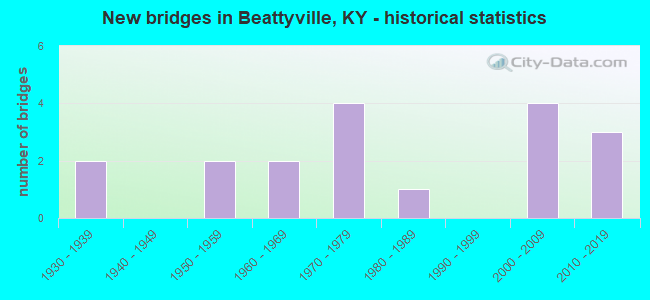
- New bridges - historical statistics
- 21930-1939
- 21950-1959
- 21960-1969
- 41970-1979
- 11980-1989
- 42000-2009
- 32010-2019


- Bridge Condition - Deck
- 42.9%Very good
- 21.4%Good
- 28.6%Satisfactory
- 7.1%Fair

- Bridge Condition - Superstructure
- 35.7%Very good
- 35.7%Good
- 14.3%Satisfactory
- 7.1%Fair
- 7.1%Poor

- Bridge Condition - Substructure
- 21.4%Very good
- 50.0%Good
- 21.4%Satisfactory
- 7.1%Poor

- Bridge Condition - Channel
- 14.3%Excellent
- 21.4%Very good
- 57.1%Good
- 7.1%Satisfactory

- Bridge Condition - Culverts
- 50.0%Excellent
- 50.0%Satisfactory
Find on map >> Show street view
Structure Number: 65B00004N, Location: .2 MI W OF JCT KY 2016 (Lat: 37.579722, Lng: -83.652222), Route carried "on" structure: State highway 52, Year Built: 1951, Status: Open, Structure Length: 10.52m (34.51ft), Average Daily Traffic: 2,198 (year 2019), Truck Traffic: 7%, Average Future Daily Traffic: 1,934 (year 2039), Design Load: HS 15, Features Intersected: MIDDLE FK.KENTUCKY RIVER
Minimum Vertical Clearance: 30+ m (98+ ft), Kilometerpoint: 27.014, Lanes on structure: 2, Owner: State Highway Agency, Approaching Roadway Width: 7.3m (24.0ft), Material/Design: Concrete continuous, Design/Construction: Tee Beam, Number Of Spans In Main Unit: 4, Length of Maximum Span: 30.5m (100.1ft), Curb or Sidewalk Widths: Left: 0.4m (1.3ft), Right: 0.4m (1.3ft), Curb-To-Curb Width: 7.3m (24.0ft), Out-to-Out Width: 8.1m (26.6ft)
Condition: Deck: Fair, Superstructure: Good, Substructure: Good, Channel: Satisfactory, Operating Rating: 45.3 metric tons, Method Used To Determine Operating Rating: Load Factor (LF), Inventory Rating: 27.1 metric tons, Method Used To Determine Inventory Rating: Load Factor (LF), Structural Evaluation: Equal to present minimum criteria, Deck Geometry: High priority of replacement, Waterway Adequacy: Superior to present desirable criteria, Approach Roadway Alignment: Equal to present desirable criteria, Designated Inspection Frequency: Every 24 months, Inspection Date: March 2021, Deck Structure Type: Concrete Cast-file-Place, Wearing Surface/Protective System: Wearing Surface: Latex Concrete
Find on map >> Show street view
Structure Number: 65B00005N, Location: BETWEEN JCTS KY 52 E&W (Lat: 37.569444, Lng: -83.706667), Route carried "on" structure: State highway 11, Year Built: 1962, Status: Posted for load, Structure Length: 12.68m (41.60ft), Average Daily Traffic: 7,720 (year 2019), Truck Traffic: 7%, Average Future Daily Traffic: 6,407 (year 2039), Design Load: HS 20, Features Intersected: N. FORK OF KENTUCKY RIVE
Minimum Vertical Clearance: 30+ m (98+ ft), Kilometerpoint: 6.772, Lanes on structure: 2, Base Highway Network: Yes, Owner: State Highway Agency, Approaching Roadway Width: 10.1m (33.1ft), Material/Design: Steel, Design/Construction: Stringer/Multi-beam, Number Of Spans In Main Unit: 3, Length of Maximum Span: 51.8m (169.9ft), Curb or Sidewalk Widths: Left: 1.2m (3.9ft), Right: 1.2m (3.9ft), Curb-To-Curb Width: 9.1m (29.9ft), Out-to-Out Width: 11.7m (38.4ft)
Condition: Deck: Satisfactory, Superstructure: Good, Substructure: Good, Channel: Good, Operating Rating: 51.9 metric tons, Method Used To Determine Operating Rating: Load Factor (LF), Inventory Rating: 31.1 metric tons, Method Used To Determine Inventory Rating: Load Factor (LF), Structural Evaluation: Better than present minimum criteria, Deck Geometry: Meets minimum limits, Waterway Adequacy: Superior to present desirable criteria, Approach Roadway Alignment: Equal to present desirable criteria, Designated Inspection Frequency: Every 24 months, Underwater Inspection Frequency: Every 60 months, Inspection Date: March 2021, Underwater Inspection Date: May 2020, Deck Structure Type: Concrete Cast-file-Place, Wearing Surface/Protective System: Wearing Surface: Latex Concrete
Find on map >> Show street view
Structure Number: 65B00006N, Location: .10 MI S.W. OF JCT KY 52 (Lat: 37.567778, Lng: -83.709722), Route carried "on" structure: State highway 11, Year Built: 1956, Status: Open, Structure Length: 19.35m (63.48ft), Average Daily Traffic: 5,331 (year 2018), Truck Traffic: 8%, Average Future Daily Traffic: 4,424 (year 2038), Design Load: H 20, Features Intersected: S. FORK OF KENTUCKY RIVE
Minimum Vertical Clearance: 30+ m (98+ ft), Kilometerpoint: 6.418, Lanes on structure: 2, Base Highway Network: Yes, Owner: State Highway Agency, Approaching Roadway Width: 8.2m (26.9ft), Material/Design: Steel continuous, Design/Construction: Girder and Floorbeam System, Number Of Spans In Main Unit: 3, Number Of Approach Spans: 1, Length of Maximum Span: 76.2m (250.0ft), Curb or Sidewalk Widths: Left: 0.8m (2.6ft), Right: 0.8m (2.6ft), Curb-To-Curb Width: 9.3m (30.5ft), Out-to-Out Width: 10.2m (33.5ft)
Condition: Deck: Good, Superstructure: Good, Substructure: Satisfactory, Channel: Good, Operating Rating: 63.5 metric tons, Method Used To Determine Operating Rating: Allowable Stress (AS), Inventory Rating: 40.8 metric tons, Method Used To Determine Inventory Rating: Allowable Stress (AS), Structural Evaluation: Equal to present minimum criteria, Deck Geometry: Meets minimum limits, Waterway Adequacy: Superior to present desirable criteria, Approach Roadway Alignment: Equal to present desirable criteria, Designated Inspection Frequency: Every 24 months, Critical Feature Inspection Frequency: Every 24 months, Inspection Date: August 2020, Critical Feature Inspection Date: August 2020, Deck Structure Type: Concrete Cast-file-Place, Wearing Surface/Protective System: Wearing Surface: Low Slump Concrete, Deck Protection: Epoxy Coated Reinforcing
Find on map >> Show street view
Structure Number: 65B00012N, Location: 1.8 MI NOR. OF JCT KY 52 (Lat: 37.602500, Lng: -83.641667), Route carried "on" structure: State highway 2016, Year Built: 1973, Status: Open, Structure Length: 11.89m (39.01ft), Average Daily Traffic: 159 (year 2019), Average Future Daily Traffic: 139 (year 2039), Design Load: H 20, Features Intersected: NORTH FORK KENTUCKY RIVE
Minimum Vertical Clearance: 30+ m (98+ ft), Kilometerpoint: 2.923, Lanes on structure: 2, Owner: State Highway Agency, Approaching Roadway Width: 7.6m (24.9ft), Material/Design: Steel continuous, Design/Construction: Stringer/Multi-beam, Number Of Spans In Main Unit: 3, Length of Maximum Span: 51.8m (169.9ft), Curb or Sidewalk Widths: Left: 0.2m (0.7ft), Right: 0.2m (0.7ft), Curb-To-Curb Width: 7.3m (24.0ft), Out-to-Out Width: 8.4m (27.6ft)
Condition: Deck: Good, Superstructure: Satisfactory, Substructure: Satisfactory, Channel: Good, Operating Rating: 66.2 metric tons, Method Used To Determine Operating Rating: Load Factor (LF), Inventory Rating: 39.7 metric tons, Method Used To Determine Inventory Rating: Load Factor (LF), Structural Evaluation: Equal to present minimum criteria, Deck Geometry: Somewhat better than minimum adequacy, Waterway Adequacy: Superior to present desirable criteria, Approach Roadway Alignment: Equal to present desirable criteria, Designated Inspection Frequency: Every 24 months, Underwater Inspection Frequency: Every 60 months, Inspection Date: March 2020, Underwater Inspection Date: May 2020, Deck Structure Type: Concrete Cast-file-Place, Wearing Surface/Protective System: Wearing Surface: Latex Concrete, Deck Protection: Epoxy Coated Reinforcing
Find on map >> Show street view
Structure Number: 65B00016N, Location: OVR KY RVR AT HEIDELBERG (Lat: 37.551111, Lng: -83.771667), Route carried "on" structure: State highway 399, Year Built: 1968, Status: Posted for load, Structure Length: 14.20m (46.59ft), Average Daily Traffic: 259 (year 2018), Truck Traffic: 6%, Average Future Daily Traffic: 227 (year 2038), Design Load: H 20, Features Intersected: KENTUCKY RVR @HEIDELBERG
Minimum Vertical Clearance: 4.65m (15.26ft), Kilometerpoint: 8.052, Lanes on structure: 2, Owner: State Highway Agency, Approaching Roadway Width: 7.3m (24.0ft), Material/Design: Steel, Design/Construction: Truss - Thru, Number Of Spans In Main Unit: 1, Number Of Approach Spans: 2, Length of Maximum Span: 87.8m (288.1ft), Curb or Sidewalk Widths: Left: 0.5m (1.6ft), Right: 0.5m (1.6ft), Curb-To-Curb Width: 7.3m (24.0ft), Out-to-Out Width: 8.9m (29.2ft)
Condition: Deck: Satisfactory, Superstructure: Satisfactory, Substructure: Good, Channel: Good, Operating Rating: 11.2 metric tons, Method Used To Determine Operating Rating: Load Factor (LF), Inventory Rating: 6.7 metric tons, Method Used To Determine Inventory Rating: Load Factor (LF), Structural Evaluation: High priority of corrective action, Deck Geometry: Somewhat better than minimum adequacy, Waterway Adequacy: Superior to present desirable criteria, Approach Roadway Alignment: Equal to present desirable criteria, Bridge Posting: Required (Relationship of Operating Rating to Maximum Legal Load: > 39.9% below), Designated Inspection Frequency: Every 12 months, Critical Feature Inspection Frequency: Every 24 months, Underwater Inspection Frequency: Every 60 months, Inspection Date: September 2021, Critical Feature Inspection Date: September 2021, Underwater Inspection Date: May 2020, Deck Structure Type: Concrete Cast-file-Place, Wearing Surface/Protective System: Wearing Surface: Monolithic Concrete
Find on map >> Show street view
Structure Number: 65B00026N, Location: .7 MI W OF JCT KY 2016 (Lat: 37.579444, Lng: -83.660556), Route carried "on" structure: State highway 52, Year Built: 1987, Status: Open, Structure Length: 4.48m (14.70ft), Average Daily Traffic: 2,198 (year 2019), Truck Traffic: 7%, Average Future Daily Traffic: 1,934 (year 2039), Design Load: HS 20, Features Intersected: CSX RAILROAD
Minimum Vertical Clearance: 30+ m (98+ ft), Kilometerpoint: 26.216, Lanes on structure: 2, Owner: State Highway Agency, Approaching Roadway Width: 6.7m (22.0ft), Skew: 5 degrees, Material/Design: Prestressed concrete continuous, Design/Construction: Stringer/Multi-beam, Number Of Spans In Main Unit: 2, Length of Maximum Span: 25.3m (83.0ft), Curb-To-Curb Width: 9.1m (29.9ft), Out-to-Out Width: 10.1m (33.1ft)
Condition: Deck: Satisfactory, Superstructure: Very good, Substructure: Good, Operating Rating: 98.7 metric tons, Method Used To Determine Operating Rating: Load Factor (LF), Inventory Rating: 59.2 metric tons, Method Used To Determine Inventory Rating: Load Factor (LF), Structural Evaluation: Better than present minimum criteria, Deck Geometry: Meets minimum limits, Underclear: Somewhat better than minimum adequacy, Approach Roadway Alignment: Equal to present desirable criteria, Designated Inspection Frequency: Every 24 months, Inspection Date: March 2021, Deck Structure Type: Concrete Cast-file-Place, Wearing Surface/Protective System: Wearing Surface: Monolithic Concrete, Deck Protection: Epoxy Coated Reinforcing
Find on map >> Show street view
Structure Number: 65B00028N, Location: Silver Creek (Lat: 37.576944, Lng: -83.712222), Route carried "on" structure: State highway 52, Year Built: 2008, Status: Open, Structure Length: 2.99m (9.81ft), Average Daily Traffic: 1,687 (year 2018), Truck Traffic: 5%, Average Future Daily Traffic: 1,484 (year 2038), Design Load: HS 25 or greater, Features Intersected: Silver Creek
Minimum Vertical Clearance: 30+ m (98+ ft), Kilometerpoint: 19.827, Lanes on structure: 2, Owner: State Highway Agency, Approaching Roadway Width: 6.7m (22.0ft), Material/Design: Prestressed concrete, Design/Construction: Stringer/Multi-beam, Number Of Spans In Main Unit: 1, Length of Maximum Span: 29.0m (95.1ft), Curb-To-Curb Width: 12.5m (41.0ft), Out-to-Out Width: 13.4m (44.0ft)
Condition: Deck: Very good, Superstructure: Very good, Substructure: Good, Channel: Very good, Operating Rating: 84.5 metric tons, Method Used To Determine Operating Rating: Load Factor (LF), Inventory Rating: 50.7 metric tons, Method Used To Determine Inventory Rating: Load Factor (LF), Structural Evaluation: Better than present minimum criteria, Deck Geometry: Better than present minimum criteria, Waterway Adequacy: Equal to present desirable criteria, Approach Roadway Alignment: Equal to present desirable criteria, Designated Inspection Frequency: Every 24 months, Inspection Date: March 2021, Deck Structure Type: Concrete Cast-file-Place, Wearing Surface/Protective System: Wearing Surface: Monolithic Concrete, Deck Protection: Epoxy Coated Reinforcing
Find on map >> Show street view
Structure Number: 65B00029N, Location: Dry land (Lat: 37.576111, Lng: -83.711389), Route carried "on" structure: State highway 52, Year Built: 2008, Status: Open, Structure Length: 19.11m (62.70ft), Average Daily Traffic: 1,687 (year 2018), Truck Traffic: 5%, Average Future Daily Traffic: 1,484 (year 2038), Design Load: HS 25 or greater, Features Intersected: Dry land bridge
Minimum Vertical Clearance: 30+ m (98+ ft), Kilometerpoint: 19.983, Lanes on structure: 2, Owner: State Highway Agency, Approaching Roadway Width: 6.7m (22.0ft), Skew: 6 degrees, Material/Design: Prestressed concrete continuous, Design/Construction: Stringer/Multi-beam, Number Of Spans In Main Unit: 6, Length of Maximum Span: 33.5m (109.9ft), Curb-To-Curb Width: 12.5m (41.0ft), Out-to-Out Width: 13.3m (43.6ft)
Condition: Deck: Very good, Superstructure: Good, Substructure: Very good, Operating Rating: 75.0 metric tons, Method Used To Determine Operating Rating: Load Factor (LF), Inventory Rating: 45.0 metric tons, Method Used To Determine Inventory Rating: Load Factor (LF), Structural Evaluation: Better than present minimum criteria, Deck Geometry: Better than present minimum criteria, Approach Roadway Alignment: Equal to present desirable criteria, Designated Inspection Frequency: Every 24 months, Inspection Date: March 2021, Deck Structure Type: Concrete Cast-file-Place, Wearing Surface/Protective System: Wearing Surface: Monolithic Concrete, Deck Protection: Epoxy Coated Reinforcing
Find on map >> Show street view
Structure Number: 65B00030N, Location: 0.13 MI. W. KY 0011 JCT. (Lat: 37.573333, Lng: -83.707500), Route carried "on" structure: State highway 52, Year Built: 2008, Status: Open, Structure Length: 5.30m (17.39ft), Average Daily Traffic: 3,333 (year 2019), Truck Traffic: 5%, Average Future Daily Traffic: 2,933 (year 2039), Design Load: HS 25 or greater, Features Intersected: Crystal Creek
Minimum Vertical Clearance: 30.45m (99.90ft), Kilometerpoint: 20.419, Lanes on structure: 2, Owner: State Highway Agency, Approaching Roadway Width: 6.7m (22.0ft), Skew: 3 degrees, Material/Design: Prestressed concrete continuous, Design/Construction: Stringer/Multi-beam, Number Of Spans In Main Unit: 3, Length of Maximum Span: 22.6m (74.1ft), Curb or Sidewalk Widths: Left: 1.5m (4.9ft), Right: 1.5m (4.9ft), Curb-To-Curb Width: 8.5m (27.9ft), Out-to-Out Width: 11.2m (36.7ft)
Condition: Deck: Very good, Superstructure: Very good, Substructure: Good, Channel: Very good, Operating Rating: 69.1 metric tons, Method Used To Determine Operating Rating: Load Factor (LF), Inventory Rating: 41.5 metric tons, Method Used To Determine Inventory Rating: Load Factor (LF), Structural Evaluation: Better than present minimum criteria, Deck Geometry: Meets minimum limits, Waterway Adequacy: Equal to present desirable criteria, Approach Roadway Alignment: Equal to present desirable criteria, Designated Inspection Frequency: Every 24 months, Inspection Date: March 2021, Deck Structure Type: Concrete Cast-file-Place, Wearing Surface/Protective System: Wearing Surface: Monolithic Concrete, Deck Protection: Epoxy Coated Reinforcing
Find on map >> Show street view
Structure Number: 65B00031N, Location: 2.93 MI S of KY 11 (Lat: 37.542500, Lng: -83.680000), Route carried "on" structure: State highway 1411, Year Built: 2014, Status: Posted for load, Structure Length: 0.63m (2.07ft), Average Daily Traffic: 212 (year 2019), Average Future Daily Traffic: 186 (year 2039), Design Load: HS 25 or greater, Features Intersected: Pawpaw creek
Minimum Vertical Clearance: 30+ m (98+ ft), Kilometerpoint: 3.182, Lanes on structure: 2, Owner: State Highway Agency, Approaching Roadway Width: 5.7m (18.7ft), Material/Design: Concrete, Design/Construction: Culvert, Number Of Spans In Main Unit: 1, Length of Maximum Span: 6.3m (20.7ft)
Condition: Channel: Excellent, Culverts: Excellent, Operating Rating: 68.0 metric tons, Method Used To Determine Operating Rating: Load Factor (LF), Inventory Rating: 40.8 metric tons, Method Used To Determine Inventory Rating: Load Factor (LF), Structural Evaluation: Superior to present desirable criteria, Waterway Adequacy: Equal to present minimum criteria, Approach Roadway Alignment: Meets minimum limits, Bridge Posting: Required (Relationship of Operating Rating to Maximum Legal Load: > 39.9% below), Designated Inspection Frequency: Every 24 months, Inspection Date: March 2021
Find on map >> Show street view
Structure Number: 65B00032N, Location: .3M E of KY 2016 (Lat: 37.578611, Lng: -83.646111), Route carried "on" structure: State highway 52, Year Built: 2015, Status: Open, Structure Length: 4.18m (13.71ft), Average Daily Traffic: 1,409 (year 2018), Truck Traffic: 3%, Average Future Daily Traffic: 1,239 (year 2038), Design Load: Greater than HL93, Features Intersected: Double cabin creek
Minimum Vertical Clearance: 30+ m (98+ ft), Kilometerpoint: 27.705, Lanes on structure: 2, Owner: State Highway Agency, Approaching Roadway Width: 7.3m (24.0ft), Material/Design: Prestressed concrete, Design/Construction: Stringer/Multi-beam, Number Of Spans In Main Unit: 1, Length of Maximum Span: 39.2m (128.6ft), Curb-To-Curb Width: 9.0m (29.5ft), Out-to-Out Width: 10.0m (32.8ft)
Condition: Deck: Very good, Superstructure: Good, Substructure: Very good, Channel: Very good, Operating Rating: 97.2 metric tons, Method Used To Determine Operating Rating: Load and Resistance Factor Rating (LRFR) rating reported by rating factor(RF) method using HL-93 loadings, Inventory Rating: 82.3 metric tons, Method Used To Determine Inventory Rating: Load and Resistance Factor Rating (LRFR) rating reported by rating factor(RF) method using HL-93 loadings, Structural Evaluation: Better than present minimum criteria, Deck Geometry: Somewhat better than minimum adequacy, Waterway Adequacy: Superior to present desirable criteria, Approach Roadway Alignment: Equal to present desirable criteria, Designated Inspection Frequency: Every 24 months, Inspection Date: March 2021, Deck Structure Type: Concrete Cast-file-Place, Wearing Surface/Protective System: Wearing Surface: Monolithic Concrete, Deck Protection: Epoxy Coated Reinforcing
Find on map >> Show street view
Structure Number: 65C00005N, Location: .05 MI W OF JCT KY 1411 (Lat: 37.527778, Lng: -83.682778), Route carried "on" structure: County highway 1146, Year Built: 1971, Status: Open, Structure Length: 1.22m (4.00ft), Average Daily Traffic: 100 (year 2014), Average Future Daily Traffic: 2,034 (year 2034), Design Load: H 20, Features Intersected: BUFFALO CREEK, Facility Carried by Structure: BUFFALO ZION RD
Minimum Vertical Clearance: 30+ m (98+ ft), Kilometerpoint: 0.092, Lanes on structure: 2, Owner: County Highway Agency, Approaching Roadway Width: 5.8m (19.0ft), Material/Design: Prestressed concrete, Design/Construction: Box Beam or Girders - Multiple, Number Of Spans In Main Unit: 1, Length of Maximum Span: 11.6m (38.1ft), Curb or Sidewalk Widths: Left: 0.1m (0.3ft), Right: 0.1m (0.3ft), Curb-To-Curb Width: 6.0m (19.7ft), Out-to-Out Width: 6.5m (21.3ft)
Condition: Deck: Very good, Superstructure: Very good, Substructure: Satisfactory, Channel: Good, Operating Rating: 61.9 metric tons, Method Used To Determine Operating Rating: Load Factor (LF), Inventory Rating: 37.1 metric tons, Method Used To Determine Inventory Rating: Load Factor (LF), Structural Evaluation: Equal to present minimum criteria, Deck Geometry: Meets minimum limits, Waterway Adequacy: Equal to present desirable criteria, Approach Roadway Alignment: Better than present minimum criteria, Designated Inspection Frequency: Every 24 months, Inspection Date: March 2021, Deck Structure Type: Concrete Precast Panels, Wearing Surface/Protective System: Wearing Surface: Bituminous
Find on map >> Show street view
Structure Number: 65C00018N, Location: 0.27 MI. E. KY 11 (Lat: 37.549167, Lng: -83.712778), Route carried "on" structure: County highway 1150, Year Built: 1976, Status: Posted for load, Structure Length: 0.73m (2.40ft), Average Daily Traffic: 136 (year 2011), Average Future Daily Traffic: 118 (year 2031), Features Intersected: LONG BRANCH, Facility Carried by Structure: LONG BRANCH RD
Minimum Vertical Clearance: 30+ m (98+ ft), Kilometerpoint: 0.616, Lanes on structure: 2, Owner: County Highway Agency, Approaching Roadway Width: 4.9m (16.1ft), Skew: 4 degrees, Material/Design: Steel, Design/Construction: Stringer/Multi-beam, Number Of Spans In Main Unit: 1, Length of Maximum Span: 6.7m (22.0ft), Curb-To-Curb Width: 5.3m (17.4ft), Out-to-Out Width: 5.6m (18.4ft)
Condition: Deck: Satisfactory, Superstructure: Poor, Substructure: Good, Channel: Good, Operating Rating: 29.3 metric tons, Method Used To Determine Operating Rating: Load Factor (LF), Inventory Rating: 17.6 metric tons, Method Used To Determine Inventory Rating: Load Factor (LF), Structural Evaluation: Meets minimum limits, Deck Geometry: High priority of replacement, Waterway Adequacy: Equal to present desirable criteria, Approach Roadway Alignment: Equal to present minimum criteria, Bridge Posting: Required (Relationship of Operating Rating to Maximum Legal Load: > 39.9% below), Length Of Structure Improvement: 0.07m (0.23ft), Designated Inspection Frequency: Every 12 months, Inspection Date: March 2021, Bridge Improvement Cost: $56,000, Total Project Cost: $55,000, Deck Structure Type: Corrugated Steel, Wearing Surface/Protective System: Wearing Surface: Bituminous
Find on map >> Show street view
Structure Number: 65C00024N, Location: .05 MI N JCT CARLISLE (Lat: 37.578333, Lng: -83.712222), Route carried "on" structure: City street 1005, Year Built: 1970, Status: Posted for load, Structure Length: 0.88m (2.89ft), Average Daily Traffic: 50 (year 2006), Average Future Daily Traffic: 2,026 (year 2026), Features Intersected: SILVER CREEK, Facility Carried by Structure: SILVER CREEK RD
Minimum Vertical Clearance: 30+ m (98+ ft), Kilometerpoint: 0.053, Lanes on structure: 1, Owner: County Highway Agency, Approaching Roadway Width: 3.7m (12.1ft), Material/Design: Steel, Design/Construction: Stringer/Multi-beam, Number Of Spans In Main Unit: 1, Length of Maximum Span: 8.2m (26.9ft), Curb or Sidewalk Widths: Left: 0.2m (0.7ft), Right: 0.2m (0.7ft), Curb-To-Curb Width: 4.0m (13.1ft), Out-to-Out Width: 4.3m (14.1ft)
Condition: Deck: Good, Superstructure: Fair, Substructure: Poor, Channel: Good, Operating Rating: 16.8 metric tons, Method Used To Determine Operating Rating: Allowable Stress (AS), Inventory Rating: 10.3 metric tons, Method Used To Determine Inventory Rating: Load Factor (LF), Structural Evaluation: High priority of corrective action, Deck Geometry: Somewhat better than minimum adequacy, Waterway Adequacy: Equal to present minimum criteria, Approach Roadway Alignment: Better than present minimum criteria, Bridge Posting: Required (Relationship of Operating Rating to Maximum Legal Load: > 39.9% below), Designated Inspection Frequency: Every 12 months, Inspection Date: March 2021, Deck Structure Type: Wood or Timber, Wearing Surface/Protective System: Wearing Surface: Wood or Timber
Find on map >> Show street view
Structure Number: 65C00028N, Location: .14 miles W of JCT KY11 (Lat: 37.572222, Lng: -83.708333), Route carried "on" structure: City street 1031, Year Built: 1936, Status: Open, Structure Length: 0.64m (2.10ft), Average Daily Traffic: 7,580 (year 2012), Average Future Daily Traffic: 2,032 (year 2032), Features Intersected: Crystal creek
Minimum Vertical Clearance: 30.45m (99.90ft), Kilometerpoint: 0.782, Lanes on structure: 2, Owner: County Highway Agency, Approaching Roadway Width: 12.2m (40.0ft), Material/Design: Concrete, Design/Construction: Culvert, Number Of Spans In Main Unit: 2, Length of Maximum Span: 3.0m (9.8ft), Curb or Sidewalk Widths: Left: 3.0m (9.8ft), Right: 3.0m (9.8ft), Curb-To-Curb Width: 12.2m (40.0ft), Out-to-Out Width: 18.3m (60.0ft)
Condition: Channel: Good, Culverts: Satisfactory, Operating Rating: 89.8 metric tons, Method Used To Determine Operating Rating: Load Factor (LF), Inventory Rating: 89.8 metric tons, Method Used To Determine Inventory Rating: Load Factor (LF), Structural Evaluation: Equal to present minimum criteria, Deck Geometry: Somewhat better than minimum adequacy, Waterway Adequacy: Equal to present desirable criteria, Approach Roadway Alignment: Equal to present desirable criteria, Designated Inspection Frequency: Every 24 months, Inspection Date: March 2021
Find on map >> Show street view
Structure Number: 65C00030N, Location: 0.2 Miles from KY 52 (Lat: 37.580000, Lng: -83.711389), Route carried "on" structure: City street 1005, Year Built: 2015, Status: Open, Structure Length: 1.03m (3.38ft), Average Daily Traffic: 50 (year 2015), Average Future Daily Traffic: 2,035 (year 2035), Design Load: Greater than HL93, Features Intersected: Silver Creek, Facility Carried by Structure: Silver Creek Rd.
Minimum Vertical Clearance: 30+ m (98+ ft), Kilometerpoint: 0.299, Lanes on structure: 1, Owner: County Highway Agency, Approaching Roadway Width: 4.9m (16.1ft), Skew: 3 degrees, Material/Design: Prestressed concrete, Design/Construction: Box Beam or Girders - Multiple, Number Of Spans In Main Unit: 1, Length of Maximum Span: 9.2m (30.2ft), Curb-To-Curb Width: 4.4m (14.4ft), Out-to-Out Width: 4.9m (16.1ft)
Condition: Deck: Very good, Superstructure: Very good, Substructure: Very good, Channel: Excellent, Operating Rating: 63.2 metric tons, Method Used To Determine Operating Rating: Load and Resistance Factor Rating (LRFR) rating reported by rating factor(RF) method using HL-93 loadings, Inventory Rating: 48.9 metric tons, Method Used To Determine Inventory Rating: Load and Resistance Factor Rating (LRFR) rating reported by rating factor(RF) method using HL-93 loadings, Structural Evaluation: Equal to present desirable criteria, Deck Geometry: Equal to present minimum criteria, Waterway Adequacy: Equal to present desirable criteria, Approach Roadway Alignment: High priority of corrective action, Designated Inspection Frequency: Every 24 months, Inspection Date: March 2021, Deck Structure Type: Concrete Cast-file-Place, Wearing Surface/Protective System: Wearing Surface: Monolithic Concrete, Deck Protection: Epoxy Coated Reinforcing
Find on map >> Show street view
Structure Number: 65R00600N, Location: .3 MI W OF N-JCT KY 11 (Lat: 37.574444, Lng: -83.711667), Route carried "under" structure: City street 1031, Year Built: 1930, Structure Length: 0. m, Average Daily Traffic: 5,520 (year 2008), Truck Traffic: 6%, Features Intersected: CSX RR OVER MAIN ST-BTYV, Facility Carried by Structure: Main Street
Minimum Vertical Clearance: 3.96m (12.99ft), Kilometerpoint: 0.394, Lanes under structure: 2, Material/Design: Concrete, Design/Construction: Culvert, Length of Maximum Span: 6.1m (20.0ft)
Find on map >> Show street view
Structure Number: 65R00607N, Location: 0.1 MI N JCT KY 52 (Lat: 37.572778, Lng: -83.707222), Route carried "under" structure: State highway 52, Year Built: 2006, Structure Length: 0. m, Average Daily Traffic: 1,081 (year 2018), Truck Traffic: 3%, Features Intersected: LUMBER ST. / CRYSTAL CR., Facility Carried by Structure: LUMBER ST
Minimum Vertical Clearance: 3.40m (11.15ft), Kilometerpoint: 35.296, Lanes under structure: 2, Material/Design: Steel, Design/Construction: Stringer/Multi-beam, Length of Maximum Span: 14.6m (47.9ft)