Bridge Statistics for Bear, Delaware (DE)
Condition, Traffic, Stress, Structural Evaluation, Project Costs
- National Bridge Inventory (NBI) Statistics
- 41Number of bridges
- 515ft / 157mTotal length
- $2,450,000Total costs
- 943,537Total average daily traffic
- 101,736Total average daily truck traffic
- National Bridge Inventory (NBI) Registered Bridges for Bear
- No street view available for this location
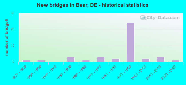
- New bridges - historical statistics
- 11920-1929
- 11930-1939
- 31950-1959
- 11960-1969
- 31970-1979
- 21980-1989
- 241990-1999
- 22000-2009
- 32010-2019
- 12020-2022
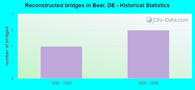
- Reconstructed bridges - Historical Statistics
- 21990-1999
- 32000-2009
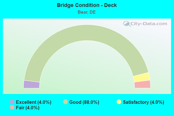
- Bridge Condition - Deck
- 4.0%Excellent
- 88.0%Good
- 4.0%Satisfactory
- 4.0%Fair
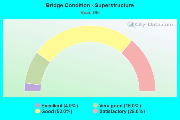
- Bridge Condition - Superstructure
- 4.0%Excellent
- 16.0%Very good
- 52.0%Good
- 28.0%Satisfactory
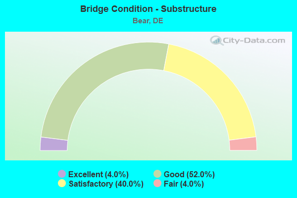
- Bridge Condition - Substructure
- 4.0%Excellent
- 52.0%Good
- 40.0%Satisfactory
- 4.0%Fair
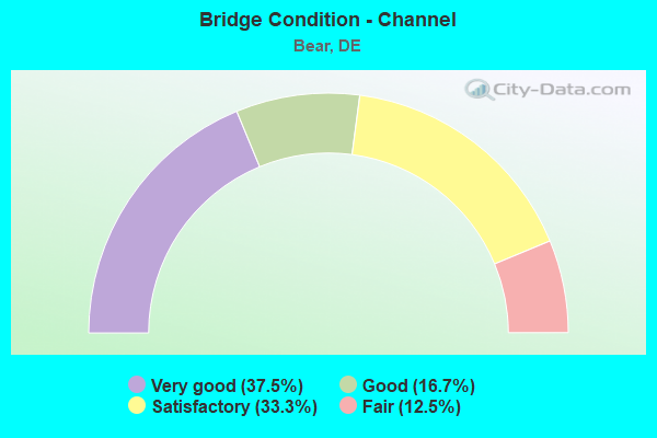
- Bridge Condition - Channel
- 37.5%Very good
- 16.7%Good
- 33.3%Satisfactory
- 12.5%Fair
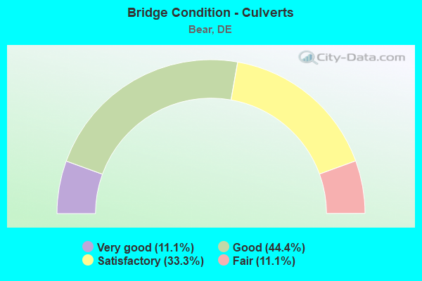
- Bridge Condition - Culverts
- 11.1%Very good
- 44.4%Good
- 33.3%Satisfactory
- 11.1%Fair
Find on map >> Show street view
Structure Number: 1220 336A, Location: CHRISTIANA FASHION CENTER (Lat: 39.673750, Lng: -75.654333), Route carried "on" structure: State highway 336A, Year Built: 2020, Status: Open, Structure Length: 7.68m (25.20ft), Average Daily Traffic: 4,675 (year 2019), Truck Traffic: 9%, Average Future Daily Traffic: 5,810 (year 2042), Design Load: HL 93, Features Intersected: SR1, Facility Carried by Structure: ROAD A
Minimum Vertical Clearance: 5.82m (19.09ft), Kilometerpoint: 0.322, Lanes on structure: 2, Lanes under structure: 9, Owner: State Highway Agency, Approaching Roadway Width: 13.4m (44.0ft), Skew: 2 degrees, Material/Design: Steel continuous, Design/Construction: Stringer/Multi-beam, Number Of Spans In Main Unit: 2, Length of Maximum Span: 39.6m (129.9ft), Curb-To-Curb Width: 13.4m (44.0ft), Out-to-Out Width: 17.6m (57.7ft)
Condition: Deck: Excellent, Superstructure: Excellent, Substructure: Excellent, Operating Rating: 56.7 metric tons, Method Used To Determine Operating Rating: Load and Resistance Factor Rating (LRFR) rating reported by rating factor(RF) method using HL-93 loadings, Inventory Rating: 43.7 metric tons, Method Used To Determine Inventory Rating: Load and Resistance Factor Rating (LRFR) rating reported by rating factor(RF) method using HL-93 loadings, Structural Evaluation: Superior to present desirable criteria, Deck Geometry: Superior to present desirable criteria, Approach Roadway Alignment: Equal to present desirable criteria, Designated Inspection Frequency: Every 24 months, Inspection Date: December 2020, Deck Structure Type: Concrete Cast-file-Place, Wearing Surface/Protective System: Wearing Surface: Integral Concrete, Deck Protection: Epoxy Coated Reinforcing
Find on map >> Show street view
Structure Number: 1222 336A, Location: CHRISTIANA MALL ENTRANCE (Lat: 39.673925, Lng: -75.654347), Route carried "on" structure: County highway 336A, Year Built: 1991, Status: Open, Structure Length: 7.71m (25.30ft), Average Daily Traffic: 9,349 (year 2019), Truck Traffic: 11%, Average Future Daily Traffic: 11,620 (year 2042), Design Load: HS 20, Features Intersected: SR 1, Facility Carried by Structure: MALL RD
Minimum Vertical Clearance: 30.48m (100.00ft), Kilometerpoint: 0.270, Lanes on structure: 2, Lanes under structure: 6, Owner: State Highway Agency, Approaching Roadway Width: 13.4m (44.0ft), Skew: 2 degrees, Material/Design: Steel continuous, Design/Construction: Stringer/Multi-beam, Number Of Spans In Main Unit: 2, Length of Maximum Span: 41.5m (136.2ft), Curb-To-Curb Width: 13.4m (44.0ft), Out-to-Out Width: 14.2m (46.6ft)
Condition: Deck: Good, Superstructure: Good, Substructure: Good, Operating Rating: 36.9 metric tons, Method Used To Determine Operating Rating: Load and Resistance Factor Rating (LRFR) rating reported by rating factor(RF) method using HL-93 loadings, Inventory Rating: 28.5 metric tons, Method Used To Determine Inventory Rating: Load and Resistance Factor Rating (LRFR) rating reported by rating factor(RF) method using HL-93 loadings, Structural Evaluation: Better than present minimum criteria, Deck Geometry: Equal to present minimum criteria, Underclear: High priority of corrective action, Approach Roadway Alignment: Equal to present desirable criteria, Designated Inspection Frequency: Every 24 months, Inspection Date: April 2020, Deck Structure Type: Concrete Cast-file-Place, Wearing Surface/Protective System: Wearing Surface: Monolithic Concrete, Deck Protection: Epoxy Coated Reinforcing
Find on map >> Show street view
Structure Number: 1223 6278, Location: CHRISTIANA MALL (Lat: 39.676556, Lng: -75.655778), Route carried "on" structure: Ramp State highway 1, Year Built: 2012, Status: Open, Structure Length: 6.67m (21.88ft), Average Daily Traffic: 9,351 (year 2019), Truck Traffic: 5%, Average Future Daily Traffic: 11,622 (year 2042), Design Load: HS 20+Mod, Features Intersected: KOREAN WAR VET MEM HGWY, Facility Carried by Structure: MALL ENTRANCE
Minimum Vertical Clearance: 30.48m (100.00ft), Kilometerpoint: 0.000, Lanes on structure: 5, Lanes under structure: 6, Owner: State Highway Agency, Approaching Roadway Width: 20.0m (65.6ft), Skew: 21 degrees, Material/Design: Steel continuous, Design/Construction: Stringer/Multi-beam, Number Of Spans In Main Unit: 2, Length of Maximum Span: 35.2m (115.5ft), Curb-To-Curb Width: 21.2m (69.6ft), Out-to-Out Width: 22.2m (72.8ft)
Condition: Deck: Good, Superstructure: Very good, Substructure: Good, Operating Rating: 47.3 metric tons, Method Used To Determine Operating Rating: Load and Resistance Factor Rating (LRFR) rating reported by rating factor(RF) method using HL-93 loadings, Inventory Rating: 36.6 metric tons, Method Used To Determine Inventory Rating: Load and Resistance Factor Rating (LRFR) rating reported by rating factor(RF) method using HL-93 loadings, Structural Evaluation: Better than present minimum criteria, Deck Geometry: Equal to present minimum criteria, Underclear: High priority of corrective action, Approach Roadway Alignment: Equal to present desirable criteria, Designated Inspection Frequency: Every 24 months, Inspection Date: April 2020, Deck Structure Type: Concrete Cast-file-Place, Wearing Surface/Protective System: Wearing Surface: Monolithic Concrete, Deck Protection: Epoxy Coated Reinforcing
Find on map >> Show street view
Structure Number: 1257 018A, Location: CHRISTIANA (Lat: 39.663978, Lng: -75.656672), Route carried "on" structure: State highway 7, Year Built: 1937, Year Reconstructed: 1997, Status: Open, Structure Length: 2.01m (6.59ft), Average Daily Traffic: 4,014 (year 2019), Truck Traffic: 11%, Average Future Daily Traffic: 5,036 (year 2043), Design Load: H 20, Features Intersected: CHRISTINA RIVER, Facility Carried by Structure: MAIN ST/CHRISTIANA
Minimum Vertical Clearance: 30.48m (100.00ft), Kilometerpoint: 0.982, Lanes on structure: 2, Owner: State Highway Agency, Approaching Roadway Width: 10.7m (35.1ft), Material/Design: Steel, Design/Construction: Stringer/Multi-beam, Number Of Spans In Main Unit: 1, Length of Maximum Span: 19.1m (62.7ft), Curb or Sidewalk Widths: Left: 1.2m (3.9ft), Right: 1.2m (3.9ft), Curb-To-Curb Width: 8.5m (27.9ft), Out-to-Out Width: 11.9m (39.0ft)
Condition: Deck: Good, Superstructure: Satisfactory, Substructure: Satisfactory, Channel: Fair, Operating Rating: 84.2 metric tons, Method Used To Determine Operating Rating: Load and Resistance Factor Rating (LRFR) rating reported by rating factor(RF) method using HL-93 loadings, Inventory Rating: 64.8 metric tons, Method Used To Determine Inventory Rating: Load and Resistance Factor Rating (LRFR) rating reported by rating factor(RF) method using HL-93 loadings, Structural Evaluation: Equal to present minimum criteria, Deck Geometry: Meets minimum limits, Waterway Adequacy: Better than present minimum criteria, Approach Roadway Alignment: Equal to present desirable criteria, Designated Inspection Frequency: Every 24 months, Inspection Date: March 2021, Deck Structure Type: Concrete Cast-file-Place, Wearing Surface/Protective System: Wearing Surface: Monolithic Concrete, Deck Protection: Epoxy Coated Reinforcing
Find on map >> Show street view
Structure Number: 1260 346, Location: NORTHWEST OF BEAR (Lat: 39.637608, Lng: -75.680714), Route carried "on" structure: County highway 346, Year Built: 1976, Status: Open, Structure Length: 5.91m (19.39ft), Average Daily Traffic: 11,089 (year 2019), Truck Traffic: 8%, Average Future Daily Traffic: 13,782 (year 2042), Design Load: HS 20, Features Intersected: CHRISTINA CREEK, Facility Carried by Structure: WALTHER ROAD
Minimum Vertical Clearance: 30.48m (100.00ft), Kilometerpoint: 1.432, Lanes on structure: 2, Owner: State Highway Agency, Approaching Roadway Width: 13.2m (43.3ft), Material/Design: Steel continuous, Design/Construction: Stringer/Multi-beam, Number Of Spans In Main Unit: 3, Length of Maximum Span: 21.3m (69.9ft), Curb-To-Curb Width: 13.2m (43.3ft), Out-to-Out Width: 15.5m (50.9ft)
Condition: Deck: Fair, Superstructure: Satisfactory, Substructure: Satisfactory, Channel: Satisfactory, Operating Rating: 53.5 metric tons, Method Used To Determine Operating Rating: Load and Resistance Factor Rating (LRFR) rating reported by rating factor(RF) method using HL-93 loadings, Inventory Rating: 38.9 metric tons, Method Used To Determine Inventory Rating: Load and Resistance Factor Rating (LRFR) rating reported by rating factor(RF) method using HL-93 loadings, Structural Evaluation: Equal to present minimum criteria, Deck Geometry: Somewhat better than minimum adequacy, Waterway Adequacy: Equal to present desirable criteria, Approach Roadway Alignment: Equal to present desirable criteria, Designated Inspection Frequency: Every 24 months, Inspection Date: May 2020, Deck Structure Type: Concrete Cast-file-Place, Wearing Surface/Protective System: Wearing Surface: Monolithic Concrete, Deck Protection: Epoxy Coated Reinforcing
Find on map >> Show street view
Structure Number: 1261 048, Location: S/E OF NEWARK (Lat: 39.635553, Lng: -75.705517), Route carried "on" structure: County highway 48, Year Built: 1958, Year Reconstructed: 1997, Status: Open, Structure Length: 1.95m (6.40ft), Average Daily Traffic: 12,035 (year 2019), Truck Traffic: 8%, Average Future Daily Traffic: 14,958 (year 2042), Design Load: HS 20+Mod, Features Intersected: CHRISTINA CREEK, Facility Carried by Structure: SALEM CHURCH RD
Minimum Vertical Clearance: 30.48m (100.00ft), Kilometerpoint: 5.470, Lanes on structure: 2, Owner: State Highway Agency, Approaching Roadway Width: 12.8m (42.0ft), Skew: 1 degrees, Material/Design: Prestressed concrete, Design/Construction: Box Beam or Girders - Multiple, Number Of Spans In Main Unit: 2, Length of Maximum Span: 9.8m (32.2ft), Curb-To-Curb Width: 11.7m (38.4ft), Out-to-Out Width: 12.3m (40.4ft)
Condition: Deck: Good, Superstructure: Good, Substructure: Satisfactory, Channel: Satisfactory, Operating Rating: 51.8 metric tons, Method Used To Determine Operating Rating: Load and Resistance Factor Rating (LRFR) rating reported by rating factor(RF) method using HL-93 loadings, Inventory Rating: 41.5 metric tons, Method Used To Determine Inventory Rating: Load and Resistance Factor Rating (LRFR) rating reported by rating factor(RF) method using HL-93 loadings, Structural Evaluation: Equal to present minimum criteria, Deck Geometry: Somewhat better than minimum adequacy, Waterway Adequacy: Equal to present minimum criteria, Approach Roadway Alignment: Equal to present desirable criteria, Designated Inspection Frequency: Every 24 months, Inspection Date: August 2020, Deck Structure Type: Concrete Cast-file-Place, Wearing Surface/Protective System: Wearing Surface: Monolithic Concrete, Deck Protection: Epoxy Coated Reinforcing
Find on map >> Show street view
Structure Number: 1266 026, Location: NORTH OF CHRISTIANA (Lat: 39.672111, Lng: -75.658383), Route carried "on" structure: State highway 26, Year Built: 1950, Status: Open, Structure Length: 0.82m (2.69ft), Average Daily Traffic: 6,006 (year 2020), Truck Traffic: 7%, Average Future Daily Traffic: 8,961 (year 2041), Design Load: HS 20, Features Intersected: TRIB. TO CHRISTINA RIVER, Facility Carried by Structure: SR 7 / N. OLD BALT
Minimum Vertical Clearance: 30.45m (99.90ft), Kilometerpoint: 12.666, Lanes on structure: 2, Owner: State Highway Agency, Approaching Roadway Width: 9.9m (32.5ft), Skew: 4 degrees, Material/Design: Concrete, Design/Construction: Culvert, Number Of Spans In Main Unit: 3, Length of Maximum Span: 1.5m (4.9ft)
Condition: Channel: Fair, Culverts: Fair, Operating Rating: 54.4 metric tons, Method Used To Determine Operating Rating: Field evaluation and documented engineering judgment, Inventory Rating: 32.7 metric tons, Method Used To Determine Inventory Rating: Field evaluation and documented engineering judgment, Structural Evaluation: Somewhat better than minimum adequacy, Waterway Adequacy: Better than present minimum criteria, Approach Roadway Alignment: Equal to present desirable criteria, Designated Inspection Frequency: Every 24 months, Underwater Inspection Frequency: Every 24 months, Inspection Date: August 2021, Underwater Inspection Date: August 2021
Find on map >> Show street view
Structure Number: 1267 026, Location: S/W OF CHRISITANA (Lat: 39.656911, Lng: -75.674900), Route carried "on" structure: County highway 26, Year Built: 1992, Status: Open, Structure Length: 0.97m (3.18ft), Average Daily Traffic: 22,244 (year 2019), Truck Traffic: 9%, Average Future Daily Traffic: 27,647 (year 2042), Design Load: HS 25 or greater, Features Intersected: TRIB. TO SMALLEYS DAM, Facility Carried by Structure: OLD BALTIMORE PIKE
Minimum Vertical Clearance: 30.48m (100.00ft), Kilometerpoint: 10.348, Lanes on structure: 3, Owner: State Highway Agency, Approaching Roadway Width: 18.9m (62.0ft), Material/Design: Concrete, Design/Construction: Culvert, Number Of Spans In Main Unit: 3, Length of Maximum Span: 3.0m (9.8ft), Curb or Sidewalk Widths: Left: 1.6m (5.2ft), Right: 1.6m (5.2ft), Curb-To-Curb Width: 19.7m (64.6ft), Out-to-Out Width: 23.0m (75.5ft)
Condition: Channel: Good, Culverts: Good, Operating Rating: 50.2 metric tons, Method Used To Determine Operating Rating: Load and Resistance Factor Rating (LRFR) rating reported by rating factor(RF) method using HL-93 loadings, Inventory Rating: 33.0 metric tons, Method Used To Determine Inventory Rating: Load and Resistance Factor Rating (LRFR) rating reported by rating factor(RF) method using HL-93 loadings, Structural Evaluation: Better than present minimum criteria, Deck Geometry: Superior to present desirable criteria, Waterway Adequacy: Equal to present minimum criteria, Approach Roadway Alignment: Equal to present desirable criteria, Designated Inspection Frequency: Every 24 months, Inspection Date: July 2020, Deck Structure Type: Concrete Precast Panels, Wearing Surface/Protective System: Wearing Surface: Bituminous, Deck Protection: Epoxy Coated Reinforcing
Find on map >> Show street view
Structure Number: 1279E003, Location: W. OF NEW CASTLE AIRPORT (Lat: 39.659183, Lng: -75.662250), Route carried "on" structure: State highway 273, Year Built: 1981, Status: Open, Structure Length: 6.74m (22.11ft), Average Daily Traffic: 18,304 (year 2019), Truck Traffic: 9%, Average Future Daily Traffic: 22,750 (year 2042), Design Load: HS 20, Features Intersected: CHRISTINA RIVER, Facility Carried by Structure: CHRISTIANA BYPASS
Minimum Vertical Clearance: 30.48m (100.00ft), Kilometerpoint: 1.287, Lanes on structure: 2, Base Highway Network: Yes, Owner: State Highway Agency, Approaching Roadway Width: 13.0m (42.7ft), Material/Design: Steel continuous, Design/Construction: Stringer/Multi-beam, Number Of Spans In Main Unit: 3, Length of Maximum Span: 25.9m (85.0ft), Curb-To-Curb Width: 12.4m (40.7ft), Out-to-Out Width: 13.3m (43.6ft)
Condition: Deck: Good, Superstructure: Satisfactory, Substructure: Satisfactory, Channel: Good, Operating Rating: 60.3 metric tons, Method Used To Determine Operating Rating: Load and Resistance Factor Rating (LRFR) rating reported by rating factor(RF) method using HL-93 loadings, Inventory Rating: 46.7 metric tons, Method Used To Determine Inventory Rating: Load and Resistance Factor Rating (LRFR) rating reported by rating factor(RF) method using HL-93 loadings, Structural Evaluation: Equal to present minimum criteria, Deck Geometry: Better than present minimum criteria, Waterway Adequacy: Superior to present desirable criteria, Approach Roadway Alignment: Equal to present desirable criteria, Designated Inspection Frequency: Every 24 months, Inspection Date: May 2020, Deck Structure Type: Concrete Cast-file-Place, Wearing Surface/Protective System: Wearing Surface: Monolithic Concrete, Deck Protection: Epoxy Coated Reinforcing
Find on map >> Show street view
Structure Number: 1279W003, Location: W. OF NEW CASTLE AIRPORT (Lat: 39.659303, Lng: -75.662128), Route carried "on" structure: State highway 273, Year Built: 1981, Status: Open, Structure Length: 6.74m (22.11ft), Average Daily Traffic: 18,304 (year 2019), Truck Traffic: 9%, Average Future Daily Traffic: 22,750 (year 2042), Design Load: HS 20, Features Intersected: CHRISTINA RIVER, Facility Carried by Structure: CHRISTIANA BYPASS
Minimum Vertical Clearance: 30.48m (100.00ft), Kilometerpoint: 11.410, Lanes on structure: 2, Base Highway Network: Yes, Owner: State Highway Agency, Approaching Roadway Width: 11.6m (38.1ft), Material/Design: Steel continuous, Design/Construction: Stringer/Multi-beam, Number Of Spans In Main Unit: 3, Length of Maximum Span: 25.9m (85.0ft), Curb-To-Curb Width: 12.4m (40.7ft), Out-to-Out Width: 13.3m (43.6ft)
Condition: Deck: Good, Superstructure: Satisfactory, Substructure: Good, Channel: Good, Operating Rating: 62.9 metric tons, Method Used To Determine Operating Rating: Load and Resistance Factor Rating (LRFR) rating reported by rating factor(RF) method using HL-93 loadings, Inventory Rating: 48.6 metric tons, Method Used To Determine Inventory Rating: Load and Resistance Factor Rating (LRFR) rating reported by rating factor(RF) method using HL-93 loadings, Structural Evaluation: Equal to present minimum criteria, Deck Geometry: Better than present minimum criteria, Waterway Adequacy: Superior to present desirable criteria, Approach Roadway Alignment: Equal to present desirable criteria, Designated Inspection Frequency: Every 24 months, Inspection Date: May 2020, Deck Structure Type: Concrete Cast-file-Place, Wearing Surface/Protective System: Wearing Surface: Monolithic Concrete, Deck Protection: Epoxy Coated Reinforcing
Find on map >> Show street view
Structure Number: 1291, Location: N. OF GOVERNOR'S SQUARE (Lat: 39.639531, Lng: -75.665150), Route carried "on" structure: Other road , Year Built: 2016, Status: Open, Structure Length: 0.75m (2.46ft), Average Daily Traffic: 99 (year 2019), Truck Traffic: 11%, Average Future Daily Traffic: 123 (year 2042), Design Load: HS 20, Features Intersected: TRIB. TO SMALLEY'S POND, Facility Carried by Structure: SONGSMITH DRIVE
Minimum Vertical Clearance: 30.48m (100.00ft), Kilometerpoint: 0.000, Lanes on structure: 2, Owner: State Highway Agency, Approaching Roadway Width: 10.1m (33.1ft), Material/Design: Concrete, Design/Construction: Culvert, Number Of Spans In Main Unit: 2, Length of Maximum Span: 3.0m (9.8ft), Curb or Sidewalk Widths: Left: 1.2m (3.9ft), Right: 1.4m (4.6ft)
Condition: Channel: Very good, Culverts: Very good, Operating Rating: 54.4 metric tons, Method Used To Determine Operating Rating: Field evaluation and documented engineering judgment, Inventory Rating: 32.7 metric tons, Method Used To Determine Inventory Rating: Field evaluation and documented engineering judgment, Structural Evaluation: Equal to present desirable criteria, Waterway Adequacy: Better than present minimum criteria, Approach Roadway Alignment: Equal to present desirable criteria, Length Of Structure Improvement: 0.82m (2.69ft), Designated Inspection Frequency: Every 24 months, Inspection Date: September 2020, Total Project Cost: $400,000
Find on map >> Show street view
Structure Number: 1298 005, Location: N/W OF DELAWARE CITY (Lat: 39.605428, Lng: -75.664850), Route carried "on" structure: State highway 7, Year Built: 1927, Status: Open, Structure Length: 0.62m (2.03ft), Average Daily Traffic: 6,080 (year 2018), Truck Traffic: 9%, Average Future Daily Traffic: 7,628 (year 2042), Design Load: H 20, Features Intersected: RED LION CREEK, Facility Carried by Structure: BEAR CORBITT RD
Minimum Vertical Clearance: 30.48m (100.00ft), Kilometerpoint: 2.961, Lanes on structure: 2, Owner: State Highway Agency, Approaching Roadway Width: 11.8m (38.7ft), Material/Design: Concrete, Design/Construction: Culvert, Number Of Spans In Main Unit: 1, Length of Maximum Span: 6.2m (20.3ft), Curb-To-Curb Width: 9.1m (29.9ft), Out-to-Out Width: 10.7m (35.1ft)
Condition: Channel: Fair, Culverts: Satisfactory, Operating Rating: 32.1 metric tons, Method Used To Determine Operating Rating: Load and Resistance Factor Rating (LRFR) rating reported by rating factor(RF) method using HL-93 loadings, Inventory Rating: 24.6 metric tons, Method Used To Determine Inventory Rating: Load and Resistance Factor Rating (LRFR) rating reported by rating factor(RF) method using HL-93 loadings, Structural Evaluation: Equal to present minimum criteria, Deck Geometry: High priority of corrective action, Waterway Adequacy: Equal to present minimum criteria, Approach Roadway Alignment: Equal to present desirable criteria, Length Of Structure Improvement: 3.05m (10.01ft), Designated Inspection Frequency: Every 24 months, Inspection Date: April 2020, Bridge Improvement Cost: $500,000, Roadway Improvement Cost: $100,000, Total Project Cost: $600,000, Deck Structure Type: Concrete Cast-file-Place, Wearing Surface/Protective System: Wearing Surface: Bituminous
Find on map >> Show street view
Structure Number: 1299 035, Location: RED LION (Lat: 39.604456, Lng: -75.668047), Route carried "on" structure: State highway 71, Year Built: 2004, Status: Open, Structure Length: 0.76m (2.49ft), Average Daily Traffic: 4,309 (year 2018), Truck Traffic: 9%, Average Future Daily Traffic: 5,406 (year 2042), Design Load: HS 20+Mod, Features Intersected: RED LION CREEK
Minimum Vertical Clearance: 30.48m (100.00ft), Kilometerpoint: 10.235, Lanes on structure: 2, Owner: State Highway Agency, Approaching Roadway Width: 12.8m (42.0ft), Material/Design: Concrete, Design/Construction: Culvert, Number Of Spans In Main Unit: 1, Length of Maximum Span: 7.6m (24.9ft), Curb-To-Curb Width: 13.4m (44.0ft), Out-to-Out Width: 14.4m (47.2ft)
Condition: Channel: Satisfactory, Culverts: Good, Operating Rating: 39.2 metric tons, Method Used To Determine Operating Rating: Load and Resistance Factor Rating (LRFR) rating reported by rating factor(RF) method using HL-93 loadings, Inventory Rating: 30.1 metric tons, Method Used To Determine Inventory Rating: Load and Resistance Factor Rating (LRFR) rating reported by rating factor(RF) method using HL-93 loadings, Structural Evaluation: Better than present minimum criteria, Deck Geometry: Better than present minimum criteria, Waterway Adequacy: Equal to present minimum criteria, Approach Roadway Alignment: Equal to present desirable criteria, Designated Inspection Frequency: Every 24 months, Inspection Date: March 2020, Bridge Improvement Cost: $800,000, Roadway Improvement Cost: $200,000, Total Project Cost: $1,000,000, Deck Structure Type: Concrete Precast Panels, Wearing Surface/Protective System: Wearing Surface: Bituminous, Deck Protection: Epoxy Coated Reinforcing
Find on map >> Show street view
Structure Number: 1305 378, Location: N/W OF DELAWARE CITY (Lat: 39.605356, Lng: -75.630108), Route carried "on" structure: State highway 9, Year Built: 1966, Status: Open, Structure Length: 1.04m (3.41ft), Average Daily Traffic: 4,982 (year 2019), Truck Traffic: 8%, Average Future Daily Traffic: 6,192 (year 2042), Design Load: HS 20, Features Intersected: RED LION CREEK
Minimum Vertical Clearance: 30.48m (100.00ft), Kilometerpoint: 6.180, Lanes on structure: 2, Owner: State Highway Agency, Approaching Roadway Width: 12.2m (40.0ft), Material/Design: Prestressed concrete, Design/Construction: Box Beam or Girders - Multiple, Number Of Spans In Main Unit: 1, Length of Maximum Span: 9.1m (29.9ft), Curb-To-Curb Width: 12.2m (40.0ft), Out-to-Out Width: 13.5m (44.3ft)
Condition: Deck: Satisfactory, Superstructure: Satisfactory, Substructure: Fair, Channel: Satisfactory, Operating Rating: 38.6 metric tons, Method Used To Determine Operating Rating: Load and Resistance Factor Rating (LRFR) rating reported by rating factor(RF) method using HL-93 loadings, Inventory Rating: 29.8 metric tons, Method Used To Determine Inventory Rating: Load and Resistance Factor Rating (LRFR) rating reported by rating factor(RF) method using HL-93 loadings, Structural Evaluation: Somewhat better than minimum adequacy, Deck Geometry: Equal to present minimum criteria, Waterway Adequacy: Better than present minimum criteria, Approach Roadway Alignment: Equal to present desirable criteria, Designated Inspection Frequency: Every 24 months, Underwater Inspection Frequency: Every 24 months, Inspection Date: July 2020, Underwater Inspection Date: April 2020, Deck Structure Type: Concrete Precast Panels, Wearing Surface/Protective System: Wearing Surface: Bituminous
Find on map >> Show street view
Structure Number: 1305N082, Location: N/W OF DELAWARE CITY (Lat: 39.605892, Lng: -75.652914), Route carried "on" structure: US 13, Year Built: 1994, Status: Open, Structure Length: 2.50m (8.20ft), Average Daily Traffic: 38,437 (year 2019), Truck Traffic: 9%, Average Future Daily Traffic: 47,774 (year 2042), Design Load: HS 25 or greater, Features Intersected: RED LION CREEK, Facility Carried by Structure: KOREAN WAR VET MEM
Minimum Vertical Clearance: 30.48m (100.00ft), Kilometerpoint: 8.336, Lanes on structure: 3, Base Highway Network: Yes, Owner: State Highway Agency, Approaching Roadway Width: 18.3m (60.0ft), Skew: 2 degrees, Material/Design: Prestressed concrete, Design/Construction: Stringer/Multi-beam, Number Of Spans In Main Unit: 1, Length of Maximum Span: 22.9m (75.1ft), Curb-To-Curb Width: 18.3m (60.0ft), Out-to-Out Width: 19.1m (62.7ft)
Condition: Deck: Good, Superstructure: Very good, Substructure: Good, Channel: Very good, Operating Rating: 66.1 metric tons, Method Used To Determine Operating Rating: Load and Resistance Factor Rating (LRFR) rating reported by rating factor(RF) method using HL-93 loadings, Inventory Rating: 50.2 metric tons, Method Used To Determine Inventory Rating: Load and Resistance Factor Rating (LRFR) rating reported by rating factor(RF) method using HL-93 loadings, Structural Evaluation: Better than present minimum criteria, Deck Geometry: Superior to present desirable criteria, Waterway Adequacy: Equal to present desirable criteria, Approach Roadway Alignment: Equal to present desirable criteria, Designated Inspection Frequency: Every 24 months, Inspection Date: August 2020, Deck Structure Type: Concrete Cast-file-Place, Wearing Surface/Protective System: Wearing Surface: Monolithic Concrete, Deck Protection: Epoxy Coated Reinforcing
Find on map >> Show street view
Structure Number: 1305S082, Location: N/W OF DELAWARE CITY (Lat: 39.605906, Lng: -75.653081), Route carried "on" structure: US 13, Year Built: 1996, Status: Open, Structure Length: 2.50m (8.20ft), Average Daily Traffic: 38,437 (year 2019), Truck Traffic: 9%, Average Future Daily Traffic: 47,774 (year 2042), Design Load: HS 25 or greater, Features Intersected: RED LION CREEK, Facility Carried by Structure: KOREAN WAR VET MEM
Minimum Vertical Clearance: 30.48m (100.00ft), Kilometerpoint: 20.583, Lanes on structure: 3, Base Highway Network: Yes, Owner: State Highway Agency, Approaching Roadway Width: 18.3m (60.0ft), Skew: 10 degrees, Material/Design: Prestressed concrete, Design/Construction: Stringer/Multi-beam, Number Of Spans In Main Unit: 1, Length of Maximum Span: 22.9m (75.1ft), Curb-To-Curb Width: 18.3m (60.0ft), Out-to-Out Width: 19.1m (62.7ft)
Condition: Deck: Good, Superstructure: Very good, Substructure: Good, Channel: Very good, Operating Rating: 95.3 metric tons, Method Used To Determine Operating Rating: Load and Resistance Factor Rating (LRFR) rating reported by rating factor(RF) method using HL-93 loadings, Inventory Rating: 50.2 metric tons, Method Used To Determine Inventory Rating: Load and Resistance Factor Rating (LRFR) rating reported by rating factor(RF) method using HL-93 loadings, Structural Evaluation: Better than present minimum criteria, Deck Geometry: Superior to present desirable criteria, Waterway Adequacy: Equal to present desirable criteria, Approach Roadway Alignment: Equal to present desirable criteria, Designated Inspection Frequency: Every 24 months, Inspection Date: August 2020, Deck Structure Type: Concrete Cast-file-Place, Wearing Surface/Protective System: Wearing Surface: Monolithic Concrete, Deck Protection: Epoxy Coated Reinforcing
Find on map >> Show street view
Structure Number: 1315N067, Location: BEAR (Lat: 39.632083, Lng: -75.652836), Route carried "on" structure: State highway 1, Year Built: 1990, Status: Open, Structure Length: 5.18m (16.99ft), Average Daily Traffic: 34,634 (year 2020), Truck Traffic: 15%, Average Future Daily Traffic: 43,047 (year 2043), Design Load: HS 25 or greater, Features Intersected: NORFOLK SOUTHERN/ RD 381, Facility Carried by Structure: KOREAN WAR VET MEM
Minimum Vertical Clearance: 30.48m (100.00ft), Kilometerpoint: 3.042, Lanes on structure: 3, Lanes under structure: 2, Base Highway Network: Yes, Owner: State Highway Agency, Approaching Roadway Width: 16.5m (54.1ft), Material/Design: Steel continuous, Design/Construction: Stringer/Multi-beam, Number Of Spans In Main Unit: 3, Length of Maximum Span: 17.7m (58.1ft), Curb-To-Curb Width: 16.5m (54.1ft), Out-to-Out Width: 17.3m (56.8ft)
Condition: Deck: Good, Superstructure: Good, Substructure: Satisfactory, Operating Rating: 48.0 metric tons, Method Used To Determine Operating Rating: Load and Resistance Factor Rating (LRFR) rating reported by rating factor(RF) method using HL-93 loadings, Inventory Rating: 36.9 metric tons, Method Used To Determine Inventory Rating: Load and Resistance Factor Rating (LRFR) rating reported by rating factor(RF) method using HL-93 loadings, Structural Evaluation: Equal to present minimum criteria, Deck Geometry: Equal to present minimum criteria, Underclear: High priority of corrective action, Approach Roadway Alignment: Equal to present desirable criteria, Length Of Structure Improvement: 5.18m (16.99ft), Designated Inspection Frequency: Every 24 months, Inspection Date: April 2021, Bridge Improvement Cost: $100,000, Roadway Improvement Cost: $10,000, Total Project Cost: $150,000, Deck Structure Type: Concrete Cast-file-Place, Wearing Surface/Protective System: Wearing Surface: Monolithic Concrete, Deck Protection: Epoxy Coated Reinforcing
Find on map >> Show street view
Structure Number: 1315S067, Location: BEAR (Lat: 39.631942, Lng: -75.653097), Route carried "on" structure: State highway 1, Year Built: 1990, Status: Open, Structure Length: 5.05m (16.57ft), Average Daily Traffic: 34,634 (year 2020), Truck Traffic: 15%, Average Future Daily Traffic: 43,047 (year 2043), Design Load: HS 25 or greater, Features Intersected: NORFOLK SOUTHERN/ RD 381, Facility Carried by Structure: KOREAN WAR VET MEM
Minimum Vertical Clearance: 30.48m (100.00ft), Kilometerpoint: 3.042, Lanes on structure: 3, Lanes under structure: 2, Base Highway Network: Yes, Owner: State Highway Agency, Approaching Roadway Width: 16.5m (54.1ft), Material/Design: Steel continuous, Design/Construction: Stringer/Multi-beam, Number Of Spans In Main Unit: 3, Length of Maximum Span: 19.7m (64.6ft), Curb-To-Curb Width: 16.5m (54.1ft), Out-to-Out Width: 17.3m (56.8ft)
Condition: Deck: Good, Superstructure: Good, Substructure: Satisfactory, Operating Rating: 47.3 metric tons, Method Used To Determine Operating Rating: Load and Resistance Factor Rating (LRFR) rating reported by rating factor(RF) method using HL-93 loadings, Inventory Rating: 36.6 metric tons, Method Used To Determine Inventory Rating: Load and Resistance Factor Rating (LRFR) rating reported by rating factor(RF) method using HL-93 loadings, Structural Evaluation: Equal to present minimum criteria, Deck Geometry: Equal to present minimum criteria, Underclear: High priority of corrective action, Approach Roadway Alignment: Equal to present desirable criteria, Length Of Structure Improvement: 5.05m (16.57ft), Designated Inspection Frequency: Every 24 months, Inspection Date: April 2021, Bridge Improvement Cost: $100,000, Roadway Improvement Cost: $10,000, Total Project Cost: $150,000, Deck Structure Type: Concrete Cast-file-Place, Wearing Surface/Protective System: Wearing Surface: Monolithic Concrete, Deck Protection: Epoxy Coated Reinforcing
Find on map >> Show street view
Structure Number: 1318 406, Location: WEST OF DELAWARE CITY (Lat: 39.597756, Lng: -75.657331), Route carried "on" structure: County highway 406, Year Built: 1992, Status: Open, Structure Length: 7.27m (23.85ft), Average Daily Traffic: 733 (year 2019), Truck Traffic: 11%, Average Future Daily Traffic: 911 (year 2042), Design Load: HS 25 or greater, Features Intersected: SR 1, Facility Carried by Structure: LOWER TWIN LANE RD
Minimum Vertical Clearance: 30.48m (100.00ft), Kilometerpoint: 2.478, Lanes on structure: 2, Lanes under structure: 6, Owner: State Highway Agency, Approaching Roadway Width: 13.4m (44.0ft), Material/Design: Steel continuous, Design/Construction: Stringer/Multi-beam, Number Of Spans In Main Unit: 2, Length of Maximum Span: 35.4m (116.1ft), Curb-To-Curb Width: 13.4m (44.0ft), Out-to-Out Width: 14.2m (46.6ft)
Condition: Deck: Good, Superstructure: Satisfactory, Substructure: Satisfactory, Operating Rating: 97.1 metric tons, Method Used To Determine Operating Rating: Load Factor (LF), Inventory Rating: 58.1 metric tons, Method Used To Determine Inventory Rating: Load Factor (LF), Structural Evaluation: Equal to present minimum criteria, Deck Geometry: Superior to present desirable criteria, Underclear: Equal to present desirable criteria, Approach Roadway Alignment: Equal to present desirable criteria, Designated Inspection Frequency: Every 24 months, Inspection Date: August 2020, Deck Structure Type: Concrete Cast-file-Place, Wearing Surface/Protective System: Wearing Surface: Monolithic Concrete, Deck Protection: Epoxy Coated Reinforcing
Find on map >> Show street view
Structure Number: 1328N067, Location: NORTH OF CHRISTIANA (Lat: 39.661250, Lng: -75.652531), Route carried "on" structure: State highway 1, Year Built: 1992, Status: Open, Structure Length: 3.72m (12.20ft), Average Daily Traffic: 41,858 (year 2019), Truck Traffic: 10%, Average Future Daily Traffic: 52,026 (year 2042), Design Load: HS 20, Features Intersected: SR273/HARES CORNER RD, Facility Carried by Structure: KOREAN WAR MEM HGY
Minimum Vertical Clearance: 30.48m (100.00ft), Kilometerpoint: 6.360, Lanes on structure: 2, Lanes under structure: 5, Base Highway Network: Yes, Toll: On toll road, Owner: State Highway Agency, Approaching Roadway Width: 12.8m (42.0ft), Skew: 1 degrees, Material/Design: Steel, Design/Construction: Stringer/Multi-beam, Number Of Spans In Main Unit: 1, Length of Maximum Span: 36.1m (118.4ft), Curb-To-Curb Width: 12.8m (42.0ft), Out-to-Out Width: 13.6m (44.6ft)
Condition: Deck: Good, Superstructure: Good, Substructure: Satisfactory, Operating Rating: 45.7 metric tons, Method Used To Determine Operating Rating: Load and Resistance Factor Rating (LRFR) rating reported by rating factor(RF) method using HL-93 loadings, Inventory Rating: 35.0 metric tons, Method Used To Determine Inventory Rating: Load and Resistance Factor Rating (LRFR) rating reported by rating factor(RF) method using HL-93 loadings, Structural Evaluation: Equal to present minimum criteria, Deck Geometry: Equal to present desirable criteria, Underclear: Somewhat better than minimum adequacy, Approach Roadway Alignment: Equal to present desirable criteria, Designated Inspection Frequency: Every 24 months, Inspection Date: August 2020, Deck Structure Type: Concrete Cast-file-Place, Wearing Surface/Protective System: Wearing Surface: Monolithic Concrete, Deck Protection: Epoxy Coated Reinforcing
Find on map >> Show street view
Structure Number: 1328S067, Location: NORTH OF CHRISTIANA (Lat: 39.661150, Lng: -75.652753), Route carried "on" structure: State highway 1, Year Built: 1992, Status: Open, Structure Length: 3.72m (12.20ft), Average Daily Traffic: 41,858 (year 2019), Truck Traffic: 10%, Average Future Daily Traffic: 52,026 (year 2042), Design Load: HS 20, Features Intersected: SR 273/HARES CORNER RD, Facility Carried by Structure: KOREAN WAR MEM HGY
Minimum Vertical Clearance: 30.48m (100.00ft), Kilometerpoint: 11.650, Lanes on structure: 2, Lanes under structure: 5, Base Highway Network: Yes, Owner: State Highway Agency, Approaching Roadway Width: 12.8m (42.0ft), Skew: 1 degrees, Material/Design: Steel, Design/Construction: Stringer/Multi-beam, Number Of Spans In Main Unit: 1, Length of Maximum Span: 36.1m (118.4ft), Curb-To-Curb Width: 12.8m (42.0ft), Out-to-Out Width: 13.6m (44.6ft)
Condition: Deck: Good, Superstructure: Good, Substructure: Satisfactory, Operating Rating: 43.4 metric tons, Method Used To Determine Operating Rating: Load and Resistance Factor Rating (LRFR) rating reported by rating factor(RF) method using HL-93 loadings, Inventory Rating: 33.4 metric tons, Method Used To Determine Inventory Rating: Load and Resistance Factor Rating (LRFR) rating reported by rating factor(RF) method using HL-93 loadings, Structural Evaluation: Equal to present minimum criteria, Deck Geometry: Equal to present desirable criteria, Underclear: High priority of corrective action, Approach Roadway Alignment: Equal to present desirable criteria, Length Of Structure Improvement: 3.72m (12.20ft), Designated Inspection Frequency: Every 24 months, Inspection Date: August 2020, Bridge Improvement Cost: $100,000, Roadway Improvement Cost: $10,000, Total Project Cost: $150,000, Deck Structure Type: Concrete Cast-file-Place, Wearing Surface/Protective System: Wearing Surface: Monolithic Concrete, Deck Protection: Epoxy Coated Reinforcing
Find on map >> Show street view
Structure Number: 1329N067, Location: EAST OF CHRISTIANA (Lat: 39.665614, Lng: -75.654592), Route carried "on" structure: State highway 1, Year Built: 1992, Status: Open, Structure Length: 21.01m (68.93ft), Average Daily Traffic: 33,277 (year 2020), Truck Traffic: 9%, Average Future Daily Traffic: 41,360 (year 2043), Design Load: HS 25 or greater, Features Intersected: CHRISTINA RIVER
Minimum Vertical Clearance: 30.48m (100.00ft), Kilometerpoint: 6.840, Lanes on structure: 3, Base Highway Network: Yes, Owner: State Highway Agency, Approaching Roadway Width: 17.3m (56.8ft), Material/Design: Prestressed concrete continuous, Design/Construction: Stringer/Multi-beam, Number Of Spans In Main Unit: 9, Length of Maximum Span: 29.9m (98.1ft), Curb-To-Curb Width: 16.5m (54.1ft), Out-to-Out Width: 17.3m (56.8ft)
Condition: Deck: Good, Superstructure: Good, Substructure: Good, Channel: Very good, Operating Rating: 58.0 metric tons, Method Used To Determine Operating Rating: Load and Resistance Factor Rating (LRFR) rating reported by rating factor(RF) method using HL-93 loadings, Inventory Rating: 41.8 metric tons, Method Used To Determine Inventory Rating: Load and Resistance Factor Rating (LRFR) rating reported by rating factor(RF) method using HL-93 loadings, Structural Evaluation: Better than present minimum criteria, Deck Geometry: Equal to present minimum criteria, Waterway Adequacy: Equal to present desirable criteria, Approach Roadway Alignment: Equal to present desirable criteria, Designated Inspection Frequency: Every 24 months, Inspection Date: April 2021, Deck Structure Type: Concrete Cast-file-Place, Wearing Surface/Protective System: Wearing Surface: Monolithic Concrete, Deck Protection: Epoxy Coated Reinforcing
Find on map >> Show street view
Structure Number: 1329S067, Location: NORTH OF CHRISTIANA (Lat: 39.665575, Lng: -75.654892), Route carried "on" structure: State highway 1, Year Built: 1992, Status: Open, Structure Length: 20.95m (68.73ft), Average Daily Traffic: 41,858 (year 2019), Truck Traffic: 15%, Average Future Daily Traffic: 52,026 (year 2042), Design Load: HS 25 or greater, Features Intersected: CHRISTINA RIVER, Facility Carried by Structure: KOREAN WAR MEM HGY
Minimum Vertical Clearance: 30.48m (100.00ft), Kilometerpoint: 14.098, Lanes on structure: 3, Base Highway Network: Yes, Owner: State Highway Agency, Approaching Roadway Width: 16.5m (54.1ft), Material/Design: Prestressed concrete continuous, Design/Construction: Stringer/Multi-beam, Number Of Spans In Main Unit: 9, Length of Maximum Span: 29.1m (95.5ft), Curb-To-Curb Width: 16.3m (53.5ft), Out-to-Out Width: 17.3m (56.8ft)
Condition: Deck: Good, Superstructure: Good, Substructure: Good, Channel: Very good, Operating Rating: 58.0 metric tons, Method Used To Determine Operating Rating: Load and Resistance Factor Rating (LRFR) rating reported by rating factor(RF) method using HL-93 loadings, Inventory Rating: 41.8 metric tons, Method Used To Determine Inventory Rating: Load and Resistance Factor Rating (LRFR) rating reported by rating factor(RF) method using HL-93 loadings, Structural Evaluation: Better than present minimum criteria, Deck Geometry: Better than present minimum criteria, Waterway Adequacy: Equal to present minimum criteria, Approach Roadway Alignment: Equal to present desirable criteria, Designated Inspection Frequency: Every 24 months, Inspection Date: May 2020, Deck Structure Type: Concrete Cast-file-Place, Wearing Surface/Protective System: Wearing Surface: Monolithic Concrete, Deck Protection: Epoxy Coated Reinforcing
Find on map >> Show street view
Structure Number: 1331A6332, Location: CHRISTIANA (Lat: 39.670503, Lng: -75.654256), Route carried "on" structure: Ramp State highway 6332, Year Built: 1997, Status: Open, Structure Length: 5.17m (16.96ft), Average Daily Traffic: 1,934 (year 2019), Truck Traffic: 7%, Average Future Daily Traffic: 2,403 (year 2042), Design Load: HS 25 or greater, Features Intersected: EAGLE RUN
Minimum Vertical Clearance: 30.48m (100.00ft), Kilometerpoint: 0.064, Lanes on structure: 1, Owner: State Highway Agency, Approaching Roadway Width: 7.8m (25.6ft), Material/Design: Prestressed concrete continuous, Design/Construction: Box Beam or Girders - Single/Spread, Number Of Spans In Main Unit: 3, Length of Maximum Span: 16.5m (54.1ft), Curb-To-Curb Width: 7.9m (25.9ft), Out-to-Out Width: 8.7m (28.5ft)
Condition: Deck: Good, Superstructure: Good, Substructure: Good, Channel: Satisfactory, Operating Rating: 62.9 metric tons, Method Used To Determine Operating Rating: Load and Resistance Factor Rating (LRFR) rating reported by rating factor(RF) method using HL-93 loadings, Inventory Rating: 47.3 metric tons, Method Used To Determine Inventory Rating: Load and Resistance Factor Rating (LRFR) rating reported by rating factor(RF) method using HL-93 loadings, Structural Evaluation: Better than present minimum criteria, Deck Geometry: Equal to present desirable criteria, Waterway Adequacy: Equal to present desirable criteria, Approach Roadway Alignment: Equal to present desirable criteria, Designated Inspection Frequency: Every 24 months, Inspection Date: July 2020, Deck Structure Type: Concrete Cast-file-Place, Wearing Surface/Protective System: Wearing Surface: Monolithic Concrete, Deck Protection: Epoxy Coated Reinforcing
Find on map >> Show street view
Structure Number: 1331B6338, Location: NORTH OF CHRISTIANA (Lat: 39.670853, Lng: -75.655042), Route carried "on" structure: Ramp State highway 1, Year Built: 1992, Status: Open, Structure Length: 6.93m (22.74ft), Average Daily Traffic: 8,710 (year 2019), Truck Traffic: 7%, Average Future Daily Traffic: 10,825 (year 2042), Design Load: HS 25 or greater, Features Intersected: EAGLE RUN
Minimum Vertical Clearance: 30.48m (100.00ft), Kilometerpoint: 0.220, Lanes on structure: 1, Owner: State Highway Agency, Approaching Roadway Width: 7.9m (25.9ft), Material/Design: Prestressed concrete continuous, Design/Construction: Box Beam or Girders - Single/Spread, Number Of Spans In Main Unit: 4, Length of Maximum Span: 18.3m (60.0ft), Curb-To-Curb Width: 7.9m (25.9ft), Out-to-Out Width: 8.8m (28.9ft)
Condition: Deck: Good, Superstructure: Good, Substructure: Good, Channel: Satisfactory, Operating Rating: 56.1 metric tons, Method Used To Determine Operating Rating: Load and Resistance Factor Rating (LRFR) rating reported by rating factor(RF) method using HL-93 loadings, Inventory Rating: 44.1 metric tons, Method Used To Determine Inventory Rating: Load and Resistance Factor Rating (LRFR) rating reported by rating factor(RF) method using HL-93 loadings, Structural Evaluation: Better than present minimum criteria, Deck Geometry: Equal to present desirable criteria, Waterway Adequacy: Equal to present desirable criteria, Approach Roadway Alignment: Equal to present desirable criteria, Designated Inspection Frequency: Every 24 months, Inspection Date: July 2020, Deck Structure Type: Concrete Cast-file-Place, Wearing Surface/Protective System: Wearing Surface: Monolithic Concrete, Deck Protection: Epoxy Coated Reinforcing
Find on map >> Show street view
Structure Number: 1331N067, Location: CHRISTIANA (Lat: 39.670664, Lng: -75.654564), Route carried "on" structure: State highway 1, Year Built: 1992, Year Reconstructed: 2013, Status: Open, Structure Length: 6.28m (20.60ft), Average Daily Traffic: 42,960 (year 2019), Truck Traffic: 15%, Average Future Daily Traffic: 53,396 (year 2042), Design Load: HS 25 or greater, Features Intersected: EAGLE RUN
Minimum Vertical Clearance: 30.48m (100.00ft), Kilometerpoint: 7.435, Lanes on structure: 3, Base Highway Network: Yes, Toll: On toll road, Owner: State Highway Agency, Approaching Roadway Width: 12.8m (42.0ft), Skew: 2 degrees, Material/Design: Prestressed concrete, Design/Construction: Box Beam or Girders - Multiple, Number Of Spans In Main Unit: 3, Length of Maximum Span: 21.3m (69.9ft), Curb-To-Curb Width: 16.5m (54.1ft), Out-to-Out Width: 17.3m (56.8ft)
Condition: Deck: Good, Superstructure: Good, Substructure: Good, Channel: Satisfactory, Operating Rating: 63.2 metric tons, Method Used To Determine Operating Rating: Load and Resistance Factor Rating (LRFR) rating reported by rating factor(RF) method using HL-93 loadings, Inventory Rating: 49.6 metric tons, Method Used To Determine Inventory Rating: Load and Resistance Factor Rating (LRFR) rating reported by rating factor(RF) method using HL-93 loadings, Structural Evaluation: Better than present minimum criteria, Deck Geometry: Equal to present minimum criteria, Waterway Adequacy: Equal to present desirable criteria, Approach Roadway Alignment: Equal to present desirable criteria, Designated Inspection Frequency: Every 24 months, Inspection Date: July 2020, Deck Structure Type: Concrete Cast-file-Place, Wearing Surface/Protective System: Wearing Surface: Monolithic Concrete, Deck Protection: Epoxy Coated Reinforcing
Find on map >> Show street view
Structure Number: 1331S067, Location: CHRISTIANA (Lat: 39.670792, Lng: -75.654778), Route carried "on" structure: State highway 1, Year Built: 1992, Year Reconstructed: 2013, Status: Open, Structure Length: 6.28m (20.60ft), Average Daily Traffic: 42,960 (year 2019), Truck Traffic: 15%, Average Future Daily Traffic: 53,396 (year 2042), Design Load: HS 25 or greater, Features Intersected: EAGLE RUN
Minimum Vertical Clearance: 30.48m (100.00ft), Kilometerpoint: 7.322, Lanes on structure: 2, Base Highway Network: Yes, Owner: State Highway Agency, Approaching Roadway Width: 16.5m (54.1ft), Skew: 2 degrees, Material/Design: Prestressed concrete, Design/Construction: Box Beam or Girders - Multiple, Number Of Spans In Main Unit: 3, Length of Maximum Span: 21.3m (69.9ft), Curb-To-Curb Width: 16.5m (54.1ft), Out-to-Out Width: 17.3m (56.8ft)
Condition: Deck: Good, Superstructure: Good, Substructure: Good, Channel: Satisfactory, Operating Rating: 62.2 metric tons, Method Used To Determine Operating Rating: Load and Resistance Factor Rating (LRFR) rating reported by rating factor(RF) method using HL-93 loadings, Inventory Rating: 48.9 metric tons, Method Used To Determine Inventory Rating: Load and Resistance Factor Rating (LRFR) rating reported by rating factor(RF) method using HL-93 loadings, Structural Evaluation: Better than present minimum criteria, Deck Geometry: Superior to present desirable criteria, Waterway Adequacy: Equal to present desirable criteria, Approach Roadway Alignment: Equal to present desirable criteria, Designated Inspection Frequency: Every 24 months, Inspection Date: July 2020, Deck Structure Type: Concrete Cast-file-Place, Wearing Surface/Protective System: Wearing Surface: Monolithic Concrete, Deck Protection: Epoxy Coated Reinforcing
Find on map >> Show street view
Structure Number: 1356 048, Location: S/E OF NEWARK (Lat: 39.631331, Lng: -75.705725), Route carried "on" structure: County highway 48, Year Built: 1958, Year Reconstructed: 2000, Status: Open, Structure Length: 1.33m (4.36ft), Average Daily Traffic: 6,643 (year 2019), Truck Traffic: 8%, Average Future Daily Traffic: 8,256 (year 2042), Design Load: HS 20, Features Intersected: MUDDY RUN, Facility Carried by Structure: SALEM CHURCH RD
Minimum Vertical Clearance: 30.48m (100.00ft), Kilometerpoint: 5.005, Lanes on structure: 2, Owner: State Highway Agency, Approaching Roadway Width: 12.8m (42.0ft), Skew: 1 degrees, Material/Design: Prestressed concrete, Design/Construction: Box Beam or Girders - Multiple, Number Of Spans In Main Unit: 1, Length of Maximum Span: 12.8m (42.0ft), Curb-To-Curb Width: 11.7m (38.4ft), Out-to-Out Width: 12.3m (40.4ft)
Condition: Deck: Good, Superstructure: Satisfactory, Substructure: Satisfactory, Channel: Very good, Operating Rating: 57.0 metric tons, Method Used To Determine Operating Rating: Load and Resistance Factor Rating (LRFR) rating reported by rating factor(RF) method using HL-93 loadings, Inventory Rating: 44.7 metric tons, Method Used To Determine Inventory Rating: Load and Resistance Factor Rating (LRFR) rating reported by rating factor(RF) method using HL-93 loadings, Structural Evaluation: Equal to present minimum criteria, Deck Geometry: Somewhat better than minimum adequacy, Waterway Adequacy: Equal to present minimum criteria, Approach Roadway Alignment: Equal to present desirable criteria, Designated Inspection Frequency: Every 24 months, Inspection Date: July 2020, Deck Structure Type: Concrete Cast-file-Place, Wearing Surface/Protective System: Wearing Surface: Monolithic Concrete, Deck Protection: Epoxy Coated Reinforcing
Find on map >> Show street view
Structure Number: 1357 048, Location: S/E OF NEWARK (Lat: 39.625272, Lng: -75.703050), Route carried "on" structure: County highway 48, Year Built: 1979, Status: Open, Structure Length: 1.19m (3.90ft), Average Daily Traffic: 6,643 (year 2019), Truck Traffic: 8%, Average Future Daily Traffic: 8,256 (year 2042), Design Load: HS 20, Features Intersected: BECKS POND/BELLTOWN RUN, Facility Carried by Structure: SALEM CHURCH RD
Minimum Vertical Clearance: 30.48m (100.00ft), Kilometerpoint: 4.265, Lanes on structure: 2, Owner: State Highway Agency, Approaching Roadway Width: 12.4m (40.7ft), Material/Design: Concrete, Design/Construction: Culvert, Number Of Spans In Main Unit: 1, Length of Maximum Span: 11.9m (39.0ft), Curb-To-Curb Width: 14.6m (47.9ft), Out-to-Out Width: 15.4m (50.5ft)
Condition: Channel: Very good, Culverts: Satisfactory, Inventory Rating: 74.6 metric tons, Method Used To Determine Inventory Rating: Load Factor (LF), Structural Evaluation: Equal to present minimum criteria, Deck Geometry: Superior to present desirable criteria, Waterway Adequacy: Equal to present desirable criteria, Approach Roadway Alignment: Equal to present desirable criteria, Designated Inspection Frequency: Every 24 months, Inspection Date: July 2020, Deck Structure Type: Concrete Cast-file-Place, Wearing Surface/Protective System: Deck Protection: Epoxy Coated Reinforcing
Find on map >> Show street view
Structure Number: 1658, Location: BEAR (Lat: 39.641044, Lng: -75.633031), Route carried "on" structure: State highway , Year Built: 1970, Status: Open, Structure Length: 0.88m (2.89ft), Average Daily Traffic: 99 (year 2019), Truck Traffic: 10%, Average Future Daily Traffic: 123 (year 2038), Design Load: HS 20, Features Intersected: ARMY CREEK, Facility Carried by Structure: PALMETTO DR
Minimum Vertical Clearance: 30.48m (100.00ft), Kilometerpoint: 0.145, Lanes on structure: 2, Owner: State Highway Agency, Approaching Roadway Width: 7.3m (24.0ft), Material/Design: Concrete, Design/Construction: Culvert, Number Of Spans In Main Unit: 3, Length of Maximum Span: 2.7m (8.9ft), Curb or Sidewalk Widths: Left: 0.9m (3.0ft), Right: 0.9m (3.0ft)
Condition: Channel: Good, Culverts: Good, Operating Rating: 54.4 metric tons, Method Used To Determine Operating Rating: Field evaluation and documented engineering judgment, Inventory Rating: 32.7 metric tons, Method Used To Determine Inventory Rating: Field evaluation and documented engineering judgment, Structural Evaluation: Better than present minimum criteria, Waterway Adequacy: Better than present minimum criteria, Approach Roadway Alignment: Equal to present desirable criteria, Designated Inspection Frequency: Every 24 months, Inspection Date: October 2020
Find on map >> Show street view
Structure Number: 1659, Location: S/W OF NEW CASTLE (Lat: 39.644244, Lng: -75.631075), Route carried "on" structure: City street , Year Built: 2005, Status: Open, Structure Length: 2.35m (7.71ft), Average Daily Traffic: 99 (year 2020), Truck Traffic: 8%, Average Future Daily Traffic: 123 (year 2043), Design Load: HS 20, Features Intersected: ARMY CREEK, Facility Carried by Structure: MALLARD RD.
Minimum Vertical Clearance: 30.48m (100.00ft), Kilometerpoint: 0.515, Lanes on structure: 2, Owner: State Highway Agency, Approaching Roadway Width: 11.0m (36.1ft), Material/Design: Steel, Design/Construction: Culvert, Number Of Spans In Main Unit: 2, Length of Maximum Span: 10.8m (35.4ft)
Condition: Channel: Very good, Culverts: Satisfactory, Operating Rating: 54.4 metric tons, Method Used To Determine Operating Rating: Field evaluation and documented engineering judgment, Inventory Rating: 32.7 metric tons, Method Used To Determine Inventory Rating: Field evaluation and documented engineering judgment, Structural Evaluation: Equal to present minimum criteria, Waterway Adequacy: Equal to present desirable criteria, Approach Roadway Alignment: Equal to present desirable criteria, Designated Inspection Frequency: Every 24 months, Inspection Date: May 2021
Find on map >> Show street view
Structure Number: 1662 032, Location: N/E OF BEAR (Lat: 39.647886, Lng: -75.632025), Route carried "on" structure: State highway 40, Year Built: 1999, Status: Open, Structure Length: 0.63m (2.07ft), Average Daily Traffic: 26,146 (year 2019), Truck Traffic: 9%, Average Future Daily Traffic: 32,806 (year 2043), Design Load: HS 20+Mod, Features Intersected: TRIB. TO ARMY CREEK
Minimum Vertical Clearance: 30.48m (100.00ft), Kilometerpoint: 14.387, Lanes on structure: 4, Base Highway Network: Yes, Owner: State Highway Agency, Approaching Roadway Width: 23.8m (78.1ft), Skew: 20 degrees, Material/Design: Concrete, Design/Construction: Culvert, Number Of Spans In Main Unit: 2, Length of Maximum Span: 3.0m (9.8ft), Curb-To-Curb Width: 37.3m (122.4ft), Out-to-Out Width: 39.6m (129.9ft)
Condition: Channel: Very good, Culverts: Good, Operating Rating: 43.7 metric tons, Method Used To Determine Operating Rating: Load and Resistance Factor Rating (LRFR) rating reported by rating factor(RF) method using HL-93 loadings, Inventory Rating: 33.7 metric tons, Method Used To Determine Inventory Rating: Load and Resistance Factor Rating (LRFR) rating reported by rating factor(RF) method using HL-93 loadings, Structural Evaluation: Better than present minimum criteria, Deck Geometry: Superior to present desirable criteria, Waterway Adequacy: Equal to present minimum criteria, Approach Roadway Alignment: Equal to present desirable criteria, Designated Inspection Frequency: Every 24 months, Inspection Date: Febuary 2021, Deck Structure Type: Concrete Precast Panels, Wearing Surface/Protective System: Wearing Surface: Bituminous, Deck Protection: Epoxy Coated Reinforcing
Find on map >> Show street view
Structure Number: 1893N082, Location: NORTH OF WRANGLE HILL (Lat: 39.589819, Lng: -75.660983), Route carried "on" structure: State highway 1, Year Built: 1995, Status: Open, Structure Length: 1.99m (6.53ft), Average Daily Traffic: 30,557 (year 2020), Truck Traffic: 9%, Average Future Daily Traffic: 37,980 (year 2043), Design Load: HS 25 or greater, Features Intersected: NORFOLK SOUTHERN
Minimum Vertical Clearance: 30.48m (100.00ft), Kilometerpoint: 6.405, Lanes on structure: 3, Base Highway Network: Yes, Owner: State Highway Agency, Approaching Roadway Width: 18.3m (60.0ft), Skew: 1 degrees, Material/Design: Steel, Design/Construction: Stringer/Multi-beam, Number Of Spans In Main Unit: 1, Length of Maximum Span: 17.7m (58.1ft), Curb-To-Curb Width: 18.3m (60.0ft), Out-to-Out Width: 19.4m (63.6ft)
Condition: Deck: Good, Superstructure: Very good, Substructure: Good, Operating Rating: 97.2 metric tons, Method Used To Determine Operating Rating: Load and Resistance Factor Rating (LRFR) rating reported by rating factor(RF) method using HL-93 loadings, Inventory Rating: 80.7 metric tons, Method Used To Determine Inventory Rating: Load and Resistance Factor Rating (LRFR) rating reported by rating factor(RF) method using HL-93 loadings, Structural Evaluation: Better than present minimum criteria, Deck Geometry: Better than present minimum criteria, Underclear: Better than present minimum criteria, Approach Roadway Alignment: Equal to present desirable criteria, Length Of Structure Improvement: 0.24m (0.79ft), Designated Inspection Frequency: Every 24 months, Inspection Date: June 2021, Deck Structure Type: Concrete Cast-file-Place, Wearing Surface/Protective System: Wearing Surface: Monolithic Concrete, Deck Protection: Epoxy Coated Reinforcing
Find on map >> Show street view
Structure Number: 1893S082, Location: NORTH OF WRANGLE HILL (Lat: 39.589894, Lng: -75.661278), Route carried "on" structure: State highway 1, Year Built: 1995, Status: Open, Structure Length: 1.99m (6.53ft), Average Daily Traffic: 30,557 (year 2020), Truck Traffic: 9%, Average Future Daily Traffic: 37,980 (year 2043), Design Load: HS 25 or greater, Features Intersected: NORFOLK SOUTHERN
Minimum Vertical Clearance: 30.48m (100.00ft), Kilometerpoint: 6.389, Lanes on structure: 3, Base Highway Network: Yes, Toll: On toll road, Owner: State Highway Agency, Approaching Roadway Width: 18.3m (60.0ft), Skew: 1 degrees, Material/Design: Steel, Design/Construction: Stringer/Multi-beam, Number Of Spans In Main Unit: 1, Length of Maximum Span: 17.7m (58.1ft), Curb-To-Curb Width: 18.3m (60.0ft), Out-to-Out Width: 19.4m (63.6ft)
Condition: Deck: Good, Superstructure: Good, Substructure: Good, Operating Rating: 97.2 metric tons, Method Used To Determine Operating Rating: Load and Resistance Factor Rating (LRFR) rating reported by rating factor(RF) method using HL-93 loadings, Inventory Rating: 80.7 metric tons, Method Used To Determine Inventory Rating: Load and Resistance Factor Rating (LRFR) rating reported by rating factor(RF) method using HL-93 loadings, Structural Evaluation: Better than present minimum criteria, Deck Geometry: Better than present minimum criteria, Underclear: Superior to present desirable criteria, Approach Roadway Alignment: Equal to present desirable criteria, Length Of Structure Improvement: 0.24m (0.79ft), Designated Inspection Frequency: Every 24 months, Inspection Date: June 2021, Deck Structure Type: Concrete Cast-file-Place, Wearing Surface/Protective System: Wearing Surface: Monolithic Concrete, Deck Protection: Epoxy Coated Reinforcing
Find on map >> Show street view
Structure Number: 1222 336A, Location: CHRISTIANA MALL ENTRANCE (Lat: 39.673925, Lng: -75.654347), Route carried "under" structure: State highway 1, Year Built: 1991, Structure Length: 0. m, Average Daily Traffic: 85,919 (year 2019), Truck Traffic: 15%, Features Intersected: SR 1, Facility Carried by Structure: MALL RD
Minimum Vertical Clearance: 6.15m (20.18ft), Kilometerpoint: 7.837, Lanes on structure: 2, Lanes under structure: 6, Material/Design: Steel continuous, Design/Construction: Stringer/Multi-beam, Length of Maximum Span: 41.5m (136.2ft)
Find on map >> Show street view
Structure Number: 1223 6278, Location: CHRISTIANA MALL (Lat: 39.676556, Lng: -75.655778), Route carried "under" structure: State highway 1, Year Built: 2012, Structure Length: 0. m, Average Daily Traffic: 85,919 (year 2019), Truck Traffic: 8%, Features Intersected: KOREAN WAR VET MEM HGWY, Facility Carried by Structure: MALL ENTRANCE
Minimum Vertical Clearance: 5.83m (19.13ft), Kilometerpoint: 8.320, Lanes on structure: 5, Lanes under structure: 6, Material/Design: Steel continuous, Design/Construction: Stringer/Multi-beam, Length of Maximum Span: 35.2m (115.5ft)
Find on map >> Show street view
Structure Number: 1315N067, Location: BEAR (Lat: 39.632083, Lng: -75.652836), Route carried "under" structure: County highway 381, Year Built: 1990, Structure Length: 0. m, Average Daily Traffic: 3,726 (year 2020), Truck Traffic: 11%, Features Intersected: NORFOLK SOUTHERN/ RD 381, Facility Carried by Structure: KOREAN WAR VET MEM
Minimum Vertical Clearance: 7.26m (23.82ft), Kilometerpoint: 2.930, Lanes on structure: 3, Lanes under structure: 2, Material/Design: Steel continuous, Design/Construction: Stringer/Multi-beam, Length of Maximum Span: 17.7m (58.1ft)
Find on map >> Show street view
Structure Number: 1315S067, Location: BEAR (Lat: 39.631942, Lng: -75.653097), Route carried "under" structure: County highway 381, Year Built: 1990, Structure Length: 0. m, Average Daily Traffic: 3,726 (year 2020), Truck Traffic: 11%, Features Intersected: NORFOLK SOUTHERN/ RD 381, Facility Carried by Structure: KOREAN WAR VET MEM
Minimum Vertical Clearance: 7.33m (24.05ft), Kilometerpoint: 2.930, Lanes on structure: 3, Lanes under structure: 2, Material/Design: Steel continuous, Design/Construction: Stringer/Multi-beam, Length of Maximum Span: 19.7m (64.6ft)
Find on map >> Show street view
Structure Number: 1318 406, Location: WEST OF DELAWARE CITY (Lat: 39.597756, Lng: -75.657331), Route carried "under" structure: State highway 1, Year Built: 1992, Structure Length: 0. m, Average Daily Traffic: 57,158 (year 2019), Truck Traffic: 10%, Features Intersected: SR 1, Facility Carried by Structure: LOWER TWIN LANE RD
Minimum Vertical Clearance: 6.15m (20.18ft), Kilometerpoint: 7.340, Lanes on structure: 2, Lanes under structure: 6, Material/Design: Steel continuous, Design/Construction: Stringer/Multi-beam, Length of Maximum Span: 35.4m (116.1ft)
Find on map >> Show street view
Structure Number: 1328N067, Location: NORTH OF CHRISTIANA (Lat: 39.661250, Lng: -75.652531), Route carried "under" structure: State highway 273, Year Built: 1992, Structure Length: 0. m, Average Daily Traffic: 36,607 (year 2019), Truck Traffic: 9%, Features Intersected: SR273/HARES CORNER RD, Facility Carried by Structure: KOREAN WAR MEM HGY
Minimum Vertical Clearance: 5.98m (19.62ft), Kilometerpoint: 2.250, Lanes on structure: 2, Lanes under structure: 5, Material/Design: Steel, Design/Construction: Stringer/Multi-beam, Length of Maximum Span: 36.1m (118.4ft)
Find on map >> Show street view
Structure Number: 1328S067, Location: NORTH OF CHRISTIANA (Lat: 39.661150, Lng: -75.652753), Route carried "under" structure: State highway 273, Year Built: 1992, Structure Length: 0. m, Average Daily Traffic: 36,607 (year 2019), Truck Traffic: 9%, Features Intersected: SR 273/HARES CORNER RD, Facility Carried by Structure: KOREAN WAR MEM HGY
Minimum Vertical Clearance: 5.97m (19.59ft), Kilometerpoint: 2.250, Lanes on structure: 2, Lanes under structure: 5, Material/Design: Steel, Design/Construction: Stringer/Multi-beam, Length of Maximum Span: 36.1m (118.4ft)