Bridge Statistics for Battle Ground, Indiana (IN)
Condition, Traffic, Stress, Structural Evaluation, Project Costs
- National Bridge Inventory (NBI) Statistics
- 39Number of bridges
- 413ft / 126mTotal length
- $3,551,000Total costs
- 282,748Total average daily traffic
- 55,841Total average daily truck traffic
- National Bridge Inventory (NBI) Registered Bridges for Battle Ground
- No street view available for this location
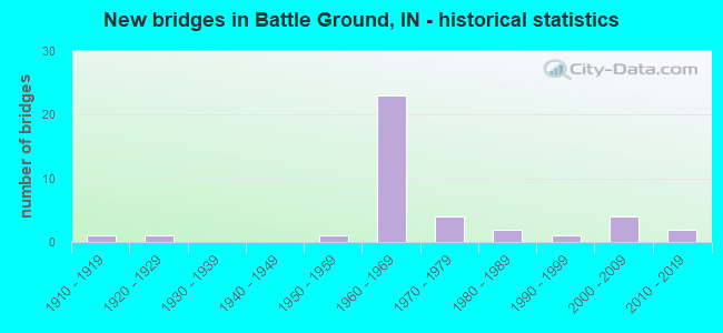
- New bridges - historical statistics
- 11910-1919
- 11920-1929
- 11950-1959
- 231960-1969
- 41970-1979
- 21980-1989
- 11990-1999
- 42000-2009
- 22010-2019

- Reconstructed bridges - Historical Statistics
- 11960-1969
- 01970-1979
- 81980-1989
- 51990-1999
- 02000-2009
- 22010-2019


- Bridge Condition - Deck
- 30.4%Good
- 30.4%Satisfactory
- 30.4%Fair
- 8.7%Poor

- Bridge Condition - Superstructure
- 13.0%Very good
- 26.1%Good
- 26.1%Satisfactory
- 26.1%Fair
- 8.7%Poor

- Bridge Condition - Substructure
- 21.7%Very good
- 34.8%Good
- 30.4%Satisfactory
- 8.7%Fair
- 4.3%Poor

- Bridge Condition - Channel
- 40.0%Very good
- 25.0%Good
- 25.0%Satisfactory
- 10.0%Fair

- Bridge Condition - Culverts
- 66.7%Good
- 33.3%Poor
Find on map >> Show street view
Structure Number: 3774, Location: 00.58 S SR 43 (Lat: 40.491869, Lng: -86.860100), Route carried "on" structure: Interstate 65, Year Built: 1968, Year Reconstructed: 1993, Status: Open, Structure Length: 14.63m (48.00ft), Average Daily Traffic: 15,585 (year 2010), Truck Traffic: 38%, Average Future Daily Traffic: 28,225 (year 2034), Design Load: HS 20+Mod, Features Intersected: CSX, N 9TH ST, BURNETT C
Minimum Vertical Clearance: 30+ m (98+ ft), Kilometerpoint: 285.369, Lanes on structure: 2, Lanes under structure: 2, Base Highway Network: Yes (, Subroute: 1), Owner: State Highway Agency, Approaching Roadway Width: 11.6m (38.1ft), Skew: 1 degrees, Material/Design: Steel continuous, Design/Construction: Stringer/Multi-beam, Number Of Spans In Main Unit: 6, Length of Maximum Span: 32.0m (105.0ft), Curb-To-Curb Width: 12.3m (40.4ft), Out-to-Out Width: 13.3m (43.6ft)
Condition: Deck: Fair, Superstructure: Satisfactory, Substructure: Satisfactory, Channel: Very good, Operating Rating: 54.9 metric tons, Method Used To Determine Operating Rating: Load Factor (LF), Inventory Rating: 32.8 metric tons, Method Used To Determine Inventory Rating: Load Factor (LF), Structural Evaluation: Equal to present minimum criteria, Deck Geometry: Better than present minimum criteria, Underclear: Superior to present desirable criteria, Waterway Adequacy: Superior to present desirable criteria, Approach Roadway Alignment: Equal to present desirable criteria, Designated Inspection Frequency: Every 24 months, Inspection Date: August 2021, Deck Structure Type: Concrete Cast-file-Place, Wearing Surface/Protective System: Wearing Surface: Monolithic Concrete, Deck Protection: Epoxy Coated Reinforcing
Find on map >> Show street view
Structure Number: 1624, Location: 01.53 N SR 225 (Lat: 40.540981, Lng: -86.869261), Route carried "on" structure: State highway 43, Year Built: 1989, Status: Open, Structure Length: 1.07m (3.51ft), Average Daily Traffic: 10,230 (year 2006), Truck Traffic: 11%, Average Future Daily Traffic: 14,169 (year 2033), Design Load: HS 20, Features Intersected: WALTERS DITCH
Minimum Vertical Clearance: 30+ m (98+ ft), Kilometerpoint: 13.438, Lanes on structure: 2, Base Highway Network: Yes (, Subroute: 1), Owner: State Highway Agency, Approaching Roadway Width: 13.4m (44.0ft), Skew: 2 degrees, Material/Design: Steel, Design/Construction: Culvert, Number Of Spans In Main Unit: 2, Length of Maximum Span: 4.7m (15.4ft), Curb-To-Curb Width: 13.4m (44.0ft), Out-to-Out Width: 13.4m (44.0ft)
Condition: Channel: Fair, Culverts: Poor, Operating Rating: 34.7 metric tons, Method Used To Determine Operating Rating: Load and Resistance Factor Rating (LRFR) rating reported by rating factor(RF) method using HL-93 loadings, Inventory Rating: 26.9 metric tons, Method Used To Determine Inventory Rating: Load and Resistance Factor Rating (LRFR) rating reported by rating factor(RF) method using HL-93 loadings, Structural Evaluation: Meets minimum limits, Deck Geometry: Equal to present minimum criteria, Waterway Adequacy: Better than present minimum criteria, Approach Roadway Alignment: Equal to present desirable criteria, Designated Inspection Frequency: Every 12 months, Inspection Date: October 2021
Find on map >> Show street view
Structure Number: 2915, Location: 00.60 N OLD SR 25 (Lat: 40.495519, Lng: -86.823289), Route carried "on" structure: State highway 225, Year Built: 1912, Year Reconstructed: 1989, Status: Posted for load, Structure Length: 19.57m (64.21ft), Average Daily Traffic: 960 (year 2009), Truck Traffic: 8%, Average Future Daily Traffic: 1,594 (year 2033), Design Load: H 20, Features Intersected: WABASH RIVER
Minimum Vertical Clearance: 5.31m (17.42ft), Kilometerpoint: 0.966, Lanes on structure: 1, Owner: State Highway Agency, Approaching Roadway Width: 5.5m (18.0ft), Material/Design: Steel, Design/Construction: Truss - Thru, Number Of Spans In Main Unit: 4, Length of Maximum Span: 48.2m (158.1ft), Curb or Sidewalk Widths: Left: 0.2m (0.7ft), Right: 0.2m (0.7ft), Curb-To-Curb Width: 4.4m (14.4ft), Out-to-Out Width: 4.7m (15.4ft)
Condition: Deck: Poor, Superstructure: Poor, Substructure: Poor, Channel: Fair, Operating Rating: 19.2 metric tons, Method Used To Determine Operating Rating: Load Factor (LF), Inventory Rating: 11.5 metric tons, Method Used To Determine Inventory Rating: Load Factor (LF), Structural Evaluation: High priority of corrective action, Deck Geometry: High priority of replacement, Waterway Adequacy: Equal to present minimum criteria, Approach Roadway Alignment: High priority of corrective action, Bridge Posting: Required (Relationship of Operating Rating to Maximum Legal Load: > 39.9% below), Designated Inspection Frequency: Every 12 months, Critical Feature Inspection Frequency: Every 12 months, Underwater Inspection Frequency: Every 60 months, Inspection Date: October 2021, Critical Feature Inspection Date: May 2021, Underwater Inspection Date: April 2019, Deck Structure Type: Concrete Cast-file-Place, Wearing Surface/Protective System: Wearing Surface: Monolithic Concrete, Deck Protection: Epoxy Coated Reinforcing
Find on map >> Show street view
Structure Number: 29155, Location: 02.66 S SR 43 (Lat: 40.502611, Lng: -86.832169), Route carried "on" structure: State highway 225, Year Built: 2003, Status: Open, Structure Length: 2.19m (7.19ft), Average Daily Traffic: 1,446 (year 2004), Truck Traffic: 10%, Average Future Daily Traffic: 2,401 (year 2034), Design Load: HS 20, Features Intersected: SWISHER RD, BIKE TRAIL
Minimum Vertical Clearance: 30+ m (98+ ft), Kilometerpoint: 2.076, Lanes on structure: 2, Lanes under structure: 2, Owner: State Highway Agency, Approaching Roadway Width: 9.8m (32.2ft), Material/Design: Concrete, Design/Construction: Culvert, Number Of Spans In Main Unit: 1, Number Of Approach Spans: 1, Length of Maximum Span: 12.8m (42.0ft), Curb-To-Curb Width: 9.7m (31.8ft), Out-to-Out Width: 9.7m (31.8ft)
Condition: Culverts: Good, Operating Rating: 54.5 metric tons, Method Used To Determine Operating Rating: Field evaluation and documented engineering judgment, Inventory Rating: 32.7 metric tons, Method Used To Determine Inventory Rating: Field evaluation and documented engineering judgment, Structural Evaluation: Better than present minimum criteria, Deck Geometry: Somewhat better than minimum adequacy, Underclear: Meets minimum limits, Approach Roadway Alignment: Equal to present desirable criteria, Designated Inspection Frequency: Every 24 months, Inspection Date: April 2021
Find on map >> Show street view
Structure Number: 2916, Location: 01.95 S SR 43 (Lat: 40.510981, Lng: -86.839981), Route carried "on" structure: State highway 225, Year Built: 1972, Year Reconstructed: 1995, Status: Open, Structure Length: 4.72m (15.49ft), Average Daily Traffic: 1,065 (year 2016), Truck Traffic: 10%, Average Future Daily Traffic: 2,204 (year 2034), Design Load: HS 20, Features Intersected: BURNETT CREEK
Minimum Vertical Clearance: 30+ m (98+ ft), Kilometerpoint: 3.299, Lanes on structure: 2, Owner: State Highway Agency, Approaching Roadway Width: 13.4m (44.0ft), Skew: 2 degrees, Material/Design: Prestressed concrete continuous, Design/Construction: Stringer/Multi-beam, Number Of Spans In Main Unit: 3, Length of Maximum Span: 15.4m (50.5ft), Curb-To-Curb Width: 12.6m (41.3ft), Out-to-Out Width: 13.6m (44.6ft)
Condition: Deck: Fair, Superstructure: Good, Substructure: Good, Channel: Satisfactory, Operating Rating: 52.5 metric tons, Method Used To Determine Operating Rating: Load and Resistance Factor Rating (LRFR) rating reported by rating factor(RF) method using HL-93 loadings, Inventory Rating: 35.0 metric tons, Method Used To Determine Inventory Rating: Load and Resistance Factor Rating (LRFR) rating reported by rating factor(RF) method using HL-93 loadings, Structural Evaluation: Better than present minimum criteria, Deck Geometry: Better than present minimum criteria, Waterway Adequacy: Superior to present desirable criteria, Approach Roadway Alignment: Equal to present desirable criteria, Length Of Structure Improvement: 4.72m (15.49ft), Designated Inspection Frequency: Every 24 months, Inspection Date: April 2021, Bridge Improvement Cost: $904,000, Total Project Cost: $904,000, Deck Structure Type: Concrete Cast-file-Place, Wearing Surface/Protective System: Wearing Surface: Latex Concrete
Find on map >> Show street view
Structure Number: 2917, Location: 01.24 S SR 43 (Lat: 40.518650, Lng: -86.845450), Route carried "on" structure: State highway 225, Year Built: 1972, Year Reconstructed: 1995, Status: Open, Structure Length: 3.78m (12.40ft), Average Daily Traffic: 990 (year 2016), Truck Traffic: 6%, Average Future Daily Traffic: 2,204 (year 2034), Design Load: HS 20, Features Intersected: BURNETT CREEK
Minimum Vertical Clearance: 30+ m (98+ ft), Kilometerpoint: 4.442, Lanes on structure: 2, Owner: State Highway Agency, Approaching Roadway Width: 11.6m (38.1ft), Material/Design: Prestressed concrete continuous, Design/Construction: Stringer/Multi-beam, Number Of Spans In Main Unit: 3, Length of Maximum Span: 12.3m (40.4ft), Curb-To-Curb Width: 12.6m (41.3ft), Out-to-Out Width: 13.6m (44.6ft)
Condition: Deck: Good, Superstructure: Good, Substructure: Satisfactory, Channel: Satisfactory, Operating Rating: 54.8 metric tons, Method Used To Determine Operating Rating: Load and Resistance Factor Rating (LRFR) rating reported by rating factor(RF) method using HL-93 loadings, Inventory Rating: 42.1 metric tons, Method Used To Determine Inventory Rating: Load and Resistance Factor Rating (LRFR) rating reported by rating factor(RF) method using HL-93 loadings, Structural Evaluation: Equal to present minimum criteria, Deck Geometry: Superior to present desirable criteria, Waterway Adequacy: Superior to present desirable criteria, Approach Roadway Alignment: Equal to present desirable criteria, Designated Inspection Frequency: Every 24 months, Inspection Date: April 2021, Deck Structure Type: Concrete Cast-file-Place, Wearing Surface/Protective System: Wearing Surface: Latex Concrete
Find on map >> Show street view
Structure Number: 3773, Location: 00.92 S SR 43 (Lat: 40.486839, Lng: -86.858111), Route carried "on" structure: Alternate County highway , Year Built: 1968, Year Reconstructed: 2017, Status: Open, Structure Length: 6.99m (22.93ft), Average Daily Traffic: 527 (year 2017), Truck Traffic: 17%, Average Future Daily Traffic: 1,614 (year 2033), Design Load: HS 20, Features Intersected: I-65 NBL and I-65 SBL, Facility Carried by Structure: SWISHER ROAD
Minimum Vertical Clearance: 30+ m (98+ ft), Kilometerpoint: 0.000, Lanes on structure: 2, Lanes under structure: 4, Owner: State Highway Agency, Approaching Roadway Width: 13.4m (44.0ft), Skew: 2 degrees, Material/Design: Steel continuous, Design/Construction: Stringer/Multi-beam, Number Of Spans In Main Unit: 2, Length of Maximum Span: 34.4m (112.9ft), Curb-To-Curb Width: 13.2m (43.3ft), Out-to-Out Width: 14.1m (46.3ft)
Condition: Deck: Good, Superstructure: Satisfactory, Substructure: Satisfactory, Operating Rating: 35.0 metric tons, Method Used To Determine Operating Rating: Load and Resistance Factor Rating (LRFR) rating reported by rating factor(RF) method using HL-93 loadings, Inventory Rating: 27.2 metric tons, Method Used To Determine Inventory Rating: Load and Resistance Factor Rating (LRFR) rating reported by rating factor(RF) method using HL-93 loadings, Structural Evaluation: Equal to present minimum criteria, Deck Geometry: Superior to present desirable criteria, Underclear: Somewhat better than minimum adequacy, Approach Roadway Alignment: Equal to present desirable criteria, Designated Inspection Frequency: Every 24 months, Inspection Date: August 2021, Deck Structure Type: Concrete Cast-file-Place, Wearing Surface/Protective System: Wearing Surface: Monolithic Concrete, Deck Protection: Epoxy Coated Reinforcing
Find on map >> Show street view
Structure Number: 3775, Location: 00.58 S SR 43 (Lat: 40.491661, Lng: -86.860350), Route carried "on" structure: Interstate 65, Year Built: 1968, Year Reconstructed: 1993, Status: Open, Structure Length: 15.27m (50.10ft), Average Daily Traffic: 15,585 (year 2010), Truck Traffic: 38%, Average Future Daily Traffic: 28,225 (year 2034), Design Load: HS 20+Mod, Features Intersected: CSX, N 9TH ST, BURNETT C
Minimum Vertical Clearance: 30+ m (98+ ft), Kilometerpoint: 285.369, Lanes on structure: 2, Lanes under structure: 2, Base Highway Network: Yes (, Subroute: 1), Owner: State Highway Agency, Approaching Roadway Width: 11.6m (38.1ft), Skew: 1 degrees, Material/Design: Steel continuous, Design/Construction: Stringer/Multi-beam, Number Of Spans In Main Unit: 6, Length of Maximum Span: 32.0m (105.0ft), Curb-To-Curb Width: 12.4m (40.7ft), Out-to-Out Width: 13.3m (43.6ft)
Condition: Deck: Satisfactory, Superstructure: Satisfactory, Substructure: Good, Channel: Good, Operating Rating: 60.2 metric tons, Method Used To Determine Operating Rating: Load Factor (LF), Inventory Rating: 36.1 metric tons, Method Used To Determine Inventory Rating: Load Factor (LF), Structural Evaluation: Equal to present minimum criteria, Deck Geometry: Better than present minimum criteria, Underclear: Equal to present minimum criteria, Waterway Adequacy: Superior to present desirable criteria, Approach Roadway Alignment: Equal to present desirable criteria, Designated Inspection Frequency: Every 24 months, Inspection Date: August 2021, Deck Structure Type: Concrete Cast-file-Place, Wearing Surface/Protective System: Wearing Surface: Monolithic Concrete, Deck Protection: Epoxy Coated Reinforcing
Find on map >> Show street view
Structure Number: 3776, Location: 00.23 S SR 43 (Lat: 40.495461, Lng: -86.864061), Route carried "on" structure: Interstate 65, Year Built: 1968, Year Reconstructed: 1993, Status: Open, Structure Length: 3.44m (11.29ft), Average Daily Traffic: 17,903 (year 2004), Truck Traffic: 10%, Average Future Daily Traffic: 32,423 (year 2034), Design Load: HS 20+Mod, Features Intersected: PROPHETS ROCK ROAD
Minimum Vertical Clearance: 30+ m (98+ ft), Kilometerpoint: 285.932, Lanes on structure: 3, Lanes under structure: 2, Base Highway Network: Yes (, Subroute: 1), Owner: State Highway Agency, Approaching Roadway Width: 15.2m (49.9ft), Skew: 1 degrees, Material/Design: Steel continuous, Design/Construction: Stringer/Multi-beam, Number Of Spans In Main Unit: 3, Length of Maximum Span: 12.2m (40.0ft), Curb-To-Curb Width: 19.6m (64.3ft), Out-to-Out Width: 20.5m (67.3ft)
Condition: Deck: Satisfactory, Superstructure: Fair, Substructure: Satisfactory, Operating Rating: 42.8 metric tons, Method Used To Determine Operating Rating: Load and Resistance Factor Rating (LRFR) rating reported by rating factor(RF) method using HL-93 loadings, Inventory Rating: 33.0 metric tons, Method Used To Determine Inventory Rating: Load and Resistance Factor Rating (LRFR) rating reported by rating factor(RF) method using HL-93 loadings, Structural Evaluation: Somewhat better than minimum adequacy, Deck Geometry: Superior to present desirable criteria, Underclear: Meets minimum limits, Approach Roadway Alignment: Equal to present desirable criteria, Designated Inspection Frequency: Every 24 months, Inspection Date: August 2021, Deck Structure Type: Concrete Cast-file-Place, Wearing Surface/Protective System: Wearing Surface: Latex Concrete
Find on map >> Show street view
Structure Number: 3777, Location: 00.23 S SR 43 (Lat: 40.495219, Lng: -86.864419), Route carried "on" structure: Interstate 65, Year Built: 1968, Year Reconstructed: 1993, Status: Open, Structure Length: 3.44m (11.29ft), Average Daily Traffic: 17,903 (year 2004), Truck Traffic: 10%, Average Future Daily Traffic: 32,423 (year 2034), Design Load: HS 20+Mod, Features Intersected: PROPHETS ROCK ROAD
Minimum Vertical Clearance: 30+ m (98+ ft), Kilometerpoint: 285.932, Lanes on structure: 3, Lanes under structure: 2, Base Highway Network: Yes (, Subroute: 1), Owner: State Highway Agency, Approaching Roadway Width: 15.2m (49.9ft), Skew: 1 degrees, Material/Design: Steel continuous, Design/Construction: Stringer/Multi-beam, Number Of Spans In Main Unit: 3, Length of Maximum Span: 12.2m (40.0ft), Curb-To-Curb Width: 17.6m (57.7ft), Out-to-Out Width: 18.6m (61.0ft)
Condition: Deck: Satisfactory, Superstructure: Poor, Substructure: Satisfactory, Operating Rating: 42.8 metric tons, Method Used To Determine Operating Rating: Load and Resistance Factor Rating (LRFR) rating reported by rating factor(RF) method using HL-93 loadings, Inventory Rating: 33.0 metric tons, Method Used To Determine Inventory Rating: Load and Resistance Factor Rating (LRFR) rating reported by rating factor(RF) method using HL-93 loadings, Structural Evaluation: Meets minimum limits, Deck Geometry: Better than present minimum criteria, Underclear: Meets minimum limits, Approach Roadway Alignment: Equal to present desirable criteria, Designated Inspection Frequency: Every 12 months, Inspection Date: August 2021, Deck Structure Type: Concrete Cast-file-Place, Wearing Surface/Protective System: Wearing Surface: Latex Concrete
Find on map >> Show street view
Structure Number: 3779, Location: 03.13 N SR 25 (Lat: 40.496681, Lng: -86.868400), Route carried "on" structure: Interstate 65, Year Built: 1968, Year Reconstructed: 1993, Status: Open, Structure Length: 4.27m (14.01ft), Average Daily Traffic: 22,529 (year 2015), Truck Traffic: 10%, Average Future Daily Traffic: 32,423 (year 2034), Design Load: HS 20+Mod, Features Intersected: SR 43
Minimum Vertical Clearance: 30+ m (98+ ft), Kilometerpoint: 286.302, Lanes on structure: 2, Lanes under structure: 4, Base Highway Network: Yes (, Subroute: 1), Owner: State Highway Agency, Approaching Roadway Width: 11.6m (38.1ft), Skew: 2 degrees, Material/Design: Steel continuous, Design/Construction: Stringer/Multi-beam, Number Of Spans In Main Unit: 2, Length of Maximum Span: 21.9m (71.9ft), Curb-To-Curb Width: 12.0m (39.4ft), Out-to-Out Width: 13.0m (42.7ft)
Condition: Deck: Fair, Superstructure: Fair, Substructure: Fair, Operating Rating: 39.9 metric tons, Method Used To Determine Operating Rating: Load and Resistance Factor Rating (LRFR) rating reported by rating factor(RF) method using HL-93 loadings, Inventory Rating: 30.8 metric tons, Method Used To Determine Inventory Rating: Load and Resistance Factor Rating (LRFR) rating reported by rating factor(RF) method using HL-93 loadings, Structural Evaluation: Somewhat better than minimum adequacy, Deck Geometry: Equal to present minimum criteria, Underclear: Somewhat better than minimum adequacy, Approach Roadway Alignment: Equal to present desirable criteria, Designated Inspection Frequency: Every 24 months, Other Special Inspection Frequency: Every 60 months, Inspection Date: August 2021, Other Special Inspection Date: June 2020, Deck Structure Type: Concrete Cast-file-Place, Wearing Surface/Protective System: Wearing Surface: Latex Concrete
Find on map >> Show street view
Structure Number: 378, Location: 00.77 N SR 43 (Lat: 40.501561, Lng: -86.882531), Route carried "on" structure: Interstate 65, Year Built: 1968, Year Reconstructed: 1993, Status: Open, Structure Length: 4.27m (14.01ft), Average Daily Traffic: 14,122 (year 2004), Truck Traffic: 10%, Average Future Daily Traffic: 25,575 (year 2030), Design Load: HS 20+Mod, Features Intersected: BURNETT CREEK
Minimum Vertical Clearance: 30+ m (98+ ft), Kilometerpoint: 287.541, Lanes on structure: 2, Base Highway Network: Yes (, Subroute: 1), Owner: State Highway Agency, Approaching Roadway Width: 11.6m (38.1ft), Material/Design: Steel continuous, Design/Construction: Stringer/Multi-beam, Number Of Spans In Main Unit: 3, Length of Maximum Span: 16.5m (54.1ft), Curb-To-Curb Width: 12.3m (40.4ft), Out-to-Out Width: 13.3m (43.6ft)
Condition: Deck: Fair, Superstructure: Fair, Substructure: Satisfactory, Channel: Very good, Operating Rating: 51.8 metric tons, Method Used To Determine Operating Rating: Load and Resistance Factor Rating (LRFR) rating reported by rating factor(RF) method using HL-93 loadings, Inventory Rating: 39.9 metric tons, Method Used To Determine Inventory Rating: Load and Resistance Factor Rating (LRFR) rating reported by rating factor(RF) method using HL-93 loadings, Structural Evaluation: Somewhat better than minimum adequacy, Deck Geometry: Better than present minimum criteria, Waterway Adequacy: Superior to present desirable criteria, Approach Roadway Alignment: Equal to present desirable criteria, Designated Inspection Frequency: Every 24 months, Inspection Date: August 2021, Deck Structure Type: Concrete Cast-file-Place, Wearing Surface/Protective System: Wearing Surface: Latex Concrete
Find on map >> Show street view
Structure Number: 3781, Location: 00.77 N SR 43 (Lat: 40.501350, Lng: -86.882681), Route carried "on" structure: Interstate 65, Year Built: 1968, Year Reconstructed: 1993, Status: Open, Structure Length: 4.27m (14.01ft), Average Daily Traffic: 14,122 (year 2004), Truck Traffic: 10%, Average Future Daily Traffic: 25,575 (year 2030), Design Load: HS 20+Mod, Features Intersected: BURNETT CREEK
Minimum Vertical Clearance: 30+ m (98+ ft), Kilometerpoint: 287.541, Lanes on structure: 2, Base Highway Network: Yes (, Subroute: 1), Owner: State Highway Agency, Approaching Roadway Width: 11.6m (38.1ft), Material/Design: Steel continuous, Design/Construction: Stringer/Multi-beam, Number Of Spans In Main Unit: 3, Length of Maximum Span: 16.5m (54.1ft), Curb-To-Curb Width: 12.5m (41.0ft), Out-to-Out Width: 13.5m (44.3ft)
Condition: Deck: Fair, Superstructure: Fair, Substructure: Good, Channel: Satisfactory, Operating Rating: 50.9 metric tons, Method Used To Determine Operating Rating: Load and Resistance Factor Rating (LRFR) rating reported by rating factor(RF) method using HL-93 loadings, Inventory Rating: 39.2 metric tons, Method Used To Determine Inventory Rating: Load and Resistance Factor Rating (LRFR) rating reported by rating factor(RF) method using HL-93 loadings, Structural Evaluation: Somewhat better than minimum adequacy, Deck Geometry: Better than present minimum criteria, Waterway Adequacy: Superior to present desirable criteria, Approach Roadway Alignment: Equal to present desirable criteria, Length Of Structure Improvement: 4.27m (14.01ft), Designated Inspection Frequency: Every 24 months, Inspection Date: August 2021, Bridge Improvement Cost: $588,000, Total Project Cost: $588,000, Deck Structure Type: Concrete Cast-file-Place, Wearing Surface/Protective System: Wearing Surface: Latex Concrete
Find on map >> Show street view
Structure Number: 3782, Location: 01.12 N SR 43 (Lat: 40.503900, Lng: -86.886181), Route carried "on" structure: County highway , Year Built: 1968, Year Reconstructed: 2017, Status: Open, Structure Length: 8.82m (28.94ft), Average Daily Traffic: 5,600 (year 2017), Truck Traffic: 4%, Average Future Daily Traffic: 7,600 (year 2037), Design Load: HS 20, Features Intersected: I-65 NB/SB, Facility Carried by Structure: CR 600N
Minimum Vertical Clearance: 30+ m (98+ ft), Kilometerpoint: 0.000, Lanes on structure: 2, Lanes under structure: 4, Owner: State Highway Agency, Approaching Roadway Width: 6.7m (22.0ft), Skew: 3 degrees, Material/Design: Steel continuous, Design/Construction: Stringer/Multi-beam, Number Of Spans In Main Unit: 2, Number Of Approach Spans: 2, Length of Maximum Span: 32.2m (105.6ft), Curb-To-Curb Width: 9.8m (32.2ft), Out-to-Out Width: 10.7m (35.1ft)
Condition: Deck: Good, Superstructure: Good, Substructure: Good, Operating Rating: 33.0 metric tons, Method Used To Determine Operating Rating: Load and Resistance Factor Rating (LRFR) rating reported by rating factor(RF) method using HL-93 loadings, Inventory Rating: 25.6 metric tons, Method Used To Determine Inventory Rating: Load and Resistance Factor Rating (LRFR) rating reported by rating factor(RF) method using HL-93 loadings, Structural Evaluation: Equal to present minimum criteria, Deck Geometry: Meets minimum limits, Underclear: Somewhat better than minimum adequacy, Approach Roadway Alignment: Equal to present desirable criteria, Designated Inspection Frequency: Every 24 months, Inspection Date: August 2021, Deck Structure Type: Concrete Cast-file-Place, Wearing Surface/Protective System: Wearing Surface: Monolithic Concrete, Deck Protection: Epoxy Coated Reinforcing
Find on map >> Show street view
Structure Number: 76808, Location: 00.65 S SR 225 (Lat: 40.508931, Lng: -86.868561), Route carried "on" structure: State highway 43, Year Built: 2008, Status: Open, Structure Length: 4.01m (13.16ft), Average Daily Traffic: 12,360 (year 2006), Truck Traffic: 9%, Average Future Daily Traffic: 17,118 (year 2033), Design Load: HS 20, Features Intersected: BURNETT CREEK
Minimum Vertical Clearance: 30+ m (98+ ft), Kilometerpoint: 9.930, Lanes on structure: 5, Base Highway Network: Yes (, Subroute: 1), Owner: State Highway Agency, Approaching Roadway Width: 20.9m (68.6ft), Skew: 1 degrees, Material/Design: Prestressed concrete, Design/Construction: Tee Beam, Number Of Spans In Main Unit: 1, Length of Maximum Span: 39.7m (130.2ft), Curb-To-Curb Width: 20.3m (66.6ft), Out-to-Out Width: 21.2m (69.6ft)
Condition: Deck: Satisfactory, Superstructure: Good, Substructure: Very good, Channel: Very good, Operating Rating: 76.8 metric tons, Method Used To Determine Operating Rating: Load and Resistance Factor Rating (LRFR) rating reported by rating factor(RF) method using HL-93 loadings, Inventory Rating: 57.0 metric tons, Method Used To Determine Inventory Rating: Load and Resistance Factor Rating (LRFR) rating reported by rating factor(RF) method using HL-93 loadings, Structural Evaluation: Better than present minimum criteria, Deck Geometry: Somewhat better than minimum adequacy, Waterway Adequacy: Superior to present desirable criteria, Approach Roadway Alignment: Equal to present desirable criteria, Designated Inspection Frequency: Every 24 months, Inspection Date: March 2021, Deck Structure Type: Concrete Cast-file-Place, Wearing Surface/Protective System: Wearing Surface: Monolithic Concrete, Deck Protection: Epoxy Coated Reinforcing
Find on map >> Show street view
Structure Number: 79001, Location: 00.19 NE of CR 500 E (Lat: 40.496189, Lng: -86.807500), Route carried "on" structure: County highway , Year Built: 1977, Status: Posted for load, Structure Length: 1.46m (4.79ft), Average Daily Traffic: 140 (year 2017), Truck Traffic: 7%, Average Future Daily Traffic: 208 (year 2038), Design Load: HS 20, Features Intersected: BUCK CREEK, Facility Carried by Structure: Stair Rd
Minimum Vertical Clearance: 30+ m (98+ ft), Kilometerpoint: 0.000, Lanes on structure: 2, Owner: County Highway Agency, Approaching Roadway Width: 5.5m (18.0ft), Material/Design: Wood or Timber, Design/Construction: Slab, Number Of Spans In Main Unit: 2, Length of Maximum Span: 7.3m (24.0ft), Curb or Sidewalk Widths: Left: 0.1m (0.3ft), Right: 0.1m (0.3ft), Curb-To-Curb Width: 7.5m (24.6ft), Out-to-Out Width: 7.9m (25.9ft)
Condition: Deck: Good, Superstructure: Good, Substructure: Fair, Channel: Very good, Operating Rating: 41.3 metric tons, Method Used To Determine Operating Rating: Allowable Stress (AS), Inventory Rating: 29.5 metric tons, Method Used To Determine Inventory Rating: Allowable Stress (AS), Structural Evaluation: Somewhat better than minimum adequacy, Deck Geometry: Somewhat better than minimum adequacy, Waterway Adequacy: Equal to present desirable criteria, Approach Roadway Alignment: Equal to present desirable criteria, Length Of Structure Improvement: 1.89m (6.20ft), Designated Inspection Frequency: Every 24 months, Inspection Date: September 2020, Bridge Improvement Cost: $281,000, Roadway Improvement Cost: $71,000, Total Project Cost: $507,000 ( Estimate for 2018), Deck Structure Type: Wood or Timber, Wearing Surface/Protective System: Wearing Surface: Bituminous
Find on map >> Show street view
Structure Number: 7900116, Location: 00.32 W of SR 43 (Lat: 40.503939, Lng: -86.874619), Route carried "on" structure: County highway 66, Year Built: 1920, Year Reconstructed: 1967, Status: Open, Structure Length: 0.98m (3.22ft), Average Daily Traffic: 5,255 (year 2016), Truck Traffic: 7%, Average Future Daily Traffic: 7,967 (year 2038), Design Load: HS 20, Features Intersected: Burnett Creek, Facility Carried by Structure: CR 600N
Minimum Vertical Clearance: 30+ m (98+ ft), Kilometerpoint: 0.000, Lanes on structure: 2, Owner: County Highway Agency, Approaching Roadway Width: 7.9m (25.9ft), Material/Design: Concrete, Design/Construction: Arch - Deck, Number Of Spans In Main Unit: 1, Length of Maximum Span: 9.8m (32.2ft), Curb or Sidewalk Widths: Left: 0.2m (0.7ft), Right: 0.2m (0.7ft), Curb-To-Curb Width: 7.9m (25.9ft), Out-to-Out Width: 9.0m (29.5ft)
Condition: Deck: Fair, Superstructure: Fair, Substructure: Good, Channel: Satisfactory, Operating Rating: 32.7 metric tons, Method Used To Determine Operating Rating: Field evaluation and documented engineering judgment, Inventory Rating: 22.7 metric tons, Method Used To Determine Inventory Rating: Field evaluation and documented engineering judgment, Structural Evaluation: Somewhat better than minimum adequacy, Deck Geometry: High priority of replacement, Waterway Adequacy: Equal to present desirable criteria, Approach Roadway Alignment: Equal to present desirable criteria, Length Of Structure Improvement: 2.65m (8.69ft), Designated Inspection Frequency: Every 24 months, Inspection Date: September 2020, Bridge Improvement Cost: $533,000, Roadway Improvement Cost: $157,000, Total Project Cost: $980,000 ( Estimate for 2018), Deck Structure Type: Concrete Cast-file-Place, Wearing Surface/Protective System: Wearing Surface: Bituminous
Find on map >> Show street view
Structure Number: 7900118, Location: 00.13 W of SR 43 (Lat: 40.512519, Lng: -86.871069), Route carried "on" structure: County highway 415, Year Built: 1959, Year Reconstructed: 1990, Status: Open, Structure Length: 2.31m (7.58ft), Average Daily Traffic: 1,974 (year 2016), Truck Traffic: 7%, Average Future Daily Traffic: 2,993 (year 2038), Design Load: HS 20, Features Intersected: North Fork Burnett Creek, Facility Carried by Structure: CR 650N
Minimum Vertical Clearance: 30+ m (98+ ft), Kilometerpoint: 0.000, Lanes on structure: 2, Owner: County Highway Agency, Approaching Roadway Width: 6.7m (22.0ft), Skew: 1 degrees, Material/Design: Prestressed concrete continuous, Design/Construction: Box Beam or Girders - Multiple, Number Of Spans In Main Unit: 3, Length of Maximum Span: 8.5m (27.9ft), Curb-To-Curb Width: 8.5m (27.9ft), Out-to-Out Width: 9.7m (31.8ft)
Condition: Deck: Good, Superstructure: Satisfactory, Substructure: Good, Channel: Good, Operating Rating: 46.9 metric tons, Method Used To Determine Operating Rating: Load and Resistance Factor (LRFR), Inventory Rating: 34.8 metric tons, Method Used To Determine Inventory Rating: Load and Resistance Factor (LRFR), Structural Evaluation: Equal to present minimum criteria, Deck Geometry: Somewhat better than minimum adequacy, Waterway Adequacy: Superior to present desirable criteria, Approach Roadway Alignment: Equal to present desirable criteria, Length Of Structure Improvement: 0.03m (0.10ft), Designated Inspection Frequency: Every 24 months, Inspection Date: September 2020, Bridge Improvement Cost: $1,000, Total Project Cost: $4,000 ( Estimate for 2018), Deck Structure Type: Concrete Cast-file-Place, Wearing Surface/Protective System: Wearing Surface: Monolithic Concrete
Find on map >> Show street view
Structure Number: 7900119, Location: 00.35 E of CR 75 E (Lat: 40.521989, Lng: -86.885750), Route carried "on" structure: County highway 228, Year Built: 1987, Status: Open, Structure Length: 2.15m (7.05ft), Average Daily Traffic: 549 (year 2016), Truck Traffic: 7%, Average Future Daily Traffic: 832 (year 2038), Design Load: HS 20, Features Intersected: North Fork Burnett Creek, Facility Carried by Structure: CR 725N
Minimum Vertical Clearance: 30+ m (98+ ft), Kilometerpoint: 0.000, Lanes on structure: 2, Owner: County Highway Agency, Approaching Roadway Width: 6.1m (20.0ft), Skew: 1 degrees, Material/Design: Concrete continuous, Design/Construction: Slab, Number Of Spans In Main Unit: 3, Length of Maximum Span: 7.9m (25.9ft), Curb-To-Curb Width: 7.3m (24.0ft), Out-to-Out Width: 8.1m (26.6ft)
Condition: Deck: Satisfactory, Superstructure: Satisfactory, Substructure: Very good, Channel: Good, Operating Rating: 43.4 metric tons, Method Used To Determine Operating Rating: Load and Resistance Factor (LRFR), Inventory Rating: 32.2 metric tons, Method Used To Determine Inventory Rating: Load and Resistance Factor (LRFR), Structural Evaluation: Equal to present minimum criteria, Deck Geometry: Meets minimum limits, Waterway Adequacy: Superior to present desirable criteria, Approach Roadway Alignment: Equal to present desirable criteria, Length Of Structure Improvement: 0.37m (1.21ft), Designated Inspection Frequency: Every 48 months, Inspection Date: September 2018, Bridge Improvement Cost: $3,000, Total Project Cost: $7,000 ( Estimate for 2018), Deck Structure Type: Concrete Cast-file-Place, Wearing Surface/Protective System: Wearing Surface: Monolithic Concrete
Find on map >> Show street view
Structure Number: 7900122, Location: 00.46 W of SR 43 (Lat: 40.532889, Lng: -86.877900), Route carried "on" structure: County highway 230, Year Built: 1971, Year Reconstructed: 2002, Status: Open, Structure Length: 1.98m (6.50ft), Average Daily Traffic: 548 (year 2017), Truck Traffic: 7%, Average Future Daily Traffic: 1,054 (year 2038), Design Load: HS 20, Features Intersected: North Fork Burnett Creek, Facility Carried by Structure: CR 800N
Minimum Vertical Clearance: 30+ m (98+ ft), Kilometerpoint: 0.000, Lanes on structure: 2, Owner: County Highway Agency, Approaching Roadway Width: 6.4m (21.0ft), Material/Design: Prestressed concrete, Design/Construction: Box Beam or Girders - Multiple, Number Of Spans In Main Unit: 1, Length of Maximum Span: 19.1m (62.7ft), Curb-To-Curb Width: 8.5m (27.9ft), Out-to-Out Width: 8.5m (27.9ft)
Condition: Deck: Satisfactory, Superstructure: Very good, Substructure: Satisfactory, Channel: Very good, Operating Rating: 61.4 metric tons, Method Used To Determine Operating Rating: Load and Resistance Factor (LRFR), Inventory Rating: 42.2 metric tons, Method Used To Determine Inventory Rating: Load and Resistance Factor (LRFR), Structural Evaluation: Equal to present minimum criteria, Deck Geometry: Somewhat better than minimum adequacy, Waterway Adequacy: Superior to present desirable criteria, Approach Roadway Alignment: Equal to present desirable criteria, Designated Inspection Frequency: Every 48 months, Inspection Date: September 2018, Deck Structure Type: Concrete Cast-file-Place, Wearing Surface/Protective System: Wearing Surface: Latex Concrete
Find on map >> Show street view
Structure Number: 7900153, Location: 00.13 N of CR 400 N (Lat: 40.476611, Lng: -86.810589), Route carried "on" structure: County highway 73, Year Built: 1963, Status: Open, Structure Length: 0.85m (2.79ft), Average Daily Traffic: 1,063 (year 2017), Truck Traffic: 7%, Average Future Daily Traffic: 1,580 (year 2038), Design Load: HS 20, Features Intersected: Dry Run Creek, Facility Carried by Structure: CR 500E
Minimum Vertical Clearance: 30+ m (98+ ft), Kilometerpoint: 0.000, Lanes on structure: 2, Owner: County Highway Agency, Approaching Roadway Width: 6.1m (20.0ft), Material/Design: Prestressed concrete, Design/Construction: Box Beam or Girders - Multiple, Number Of Spans In Main Unit: 1, Length of Maximum Span: 8.2m (26.9ft), Curb or Sidewalk Widths: Left: 0.2m (0.7ft), Right: 0.2m (0.7ft), Curb-To-Curb Width: 7.3m (24.0ft), Out-to-Out Width: 8.3m (27.2ft)
Condition: Deck: Fair, Superstructure: Fair, Substructure: Good, Channel: Good, Operating Rating: 49.5 metric tons, Method Used To Determine Operating Rating: Load Factor (LF), Inventory Rating: 29.9 metric tons, Method Used To Determine Inventory Rating: Load Factor (LF), Structural Evaluation: Somewhat better than minimum adequacy, Deck Geometry: Meets minimum limits, Waterway Adequacy: Superior to present desirable criteria, Approach Roadway Alignment: Equal to present desirable criteria, Length Of Structure Improvement: 1.19m (3.90ft), Designated Inspection Frequency: Every 24 months, Inspection Date: September 2020, Bridge Improvement Cost: $222,000, Roadway Improvement Cost: $108,000, Total Project Cost: $476,000 ( Estimate for 2018), Deck Structure Type: Concrete Precast Panels, Wearing Surface/Protective System: Wearing Surface: Bituminous
Find on map >> Show street view
Structure Number: 7900158, Location: 00.15 E of CR 300 E (Lat: 40.508931, Lng: -86.845100), Route carried "on" structure: County highway , Year Built: 1963, Year Reconstructed: 2004, Status: Open, Structure Length: 4.63m (15.19ft), Average Daily Traffic: 2,107 (year 2016), Truck Traffic: 7%, Average Future Daily Traffic: 3,194 (year 2038), Design Load: HS 20, Features Intersected: Burnett Creek, Facility Carried by Structure: Prophet Rock Rd
Minimum Vertical Clearance: 30+ m (98+ ft), Kilometerpoint: 0.000, Lanes on structure: 2, Owner: County Highway Agency, Approaching Roadway Width: 7.6m (24.9ft), Skew: 3 degrees, Material/Design: Prestressed concrete, Design/Construction: Stringer/Multi-beam, Number Of Spans In Main Unit: 3, Length of Maximum Span: 18.0m (59.1ft), Curb or Sidewalk Widths: Left: 0.3m (1.0ft), Right: 0.3m (1.0ft), Curb-To-Curb Width: 7.6m (24.9ft), Out-to-Out Width: 8.8m (28.9ft)
Condition: Deck: Poor, Superstructure: Satisfactory, Substructure: Good, Channel: Good, Operating Rating: 69.2 metric tons, Method Used To Determine Operating Rating: Load and Resistance Factor (LRFR), Inventory Rating: 40.4 metric tons, Method Used To Determine Inventory Rating: Load and Resistance Factor (LRFR), Structural Evaluation: Equal to present minimum criteria, Deck Geometry: High priority of replacement, Waterway Adequacy: Superior to present desirable criteria, Approach Roadway Alignment: Equal to present minimum criteria, Length Of Structure Improvement: 4.63m (15.19ft), Designated Inspection Frequency: Every 12 months, Inspection Date: September 2021, Bridge Improvement Cost: $43,000, Roadway Improvement Cost: $17,000, Total Project Cost: $85,000 ( Estimate for 2018), Deck Structure Type: Concrete Cast-file-Place, Wearing Surface/Protective System: Wearing Surface: Latex Concrete
Find on map >> Show street view
Structure Number: 7900212, Location: 00.15 S of CR 900 N (Lat: 40.545261, Lng: -86.892581), Route carried "on" structure: County highway 415, Year Built: 2007, Status: Open, Structure Length: 1.27m (4.17ft), Average Daily Traffic: 241 (year 2018), Truck Traffic: 7%, Average Future Daily Traffic: 351 (year 2038), Design Load: HS 20, Features Intersected: Brown Ditch, Facility Carried by Structure: CR 75E
Minimum Vertical Clearance: 30+ m (98+ ft), Kilometerpoint: 0.000, Lanes on structure: 2, Owner: County Highway Agency, Approaching Roadway Width: 5.5m (18.0ft), Skew: 2 degrees, Material/Design: Prestressed concrete, Design/Construction: Box Beam or Girders - Multiple, Number Of Spans In Main Unit: 1, Length of Maximum Span: 11.9m (39.0ft), Curb-To-Curb Width: 8.7m (28.5ft), Out-to-Out Width: 8.8m (28.9ft)
Condition: Deck: Good, Superstructure: Very good, Substructure: Very good, Channel: Very good, Operating Rating: 84.7 metric tons, Method Used To Determine Operating Rating: Load Factor (LF), Inventory Rating: 46.6 metric tons, Method Used To Determine Inventory Rating: Load Factor (LF), Structural Evaluation: Equal to present desirable criteria, Deck Geometry: Equal to present minimum criteria, Waterway Adequacy: Superior to present desirable criteria, Approach Roadway Alignment: Equal to present desirable criteria, Designated Inspection Frequency: Every 24 months, Inspection Date: September 2020, Deck Structure Type: Concrete Cast-file-Place, Wearing Surface/Protective System: Wearing Surface: Monolithic Concrete, Deck Protection: Epoxy Coated Reinforcing
Find on map >> Show street view
Structure Number: 7900217, Location: 00.44 N SR 225 (Lat: 40.495061, Lng: -86.806789), Route carried "on" structure: County highway 25, Year Built: 1998, Status: Open, Structure Length: 3.00m (9.84ft), Average Daily Traffic: 4,306 (year 2017), Truck Traffic: 7%, Average Future Daily Traffic: 6,399 (year 2038), Design Load: HS 20, Features Intersected: BUCK CREEK
Minimum Vertical Clearance: 30+ m (98+ ft), Kilometerpoint: 0.000, Lanes on structure: 2, Owner: County Highway Agency, Approaching Roadway Width: 13.4m (44.0ft), Material/Design: Prestressed concrete, Design/Construction: Tee Beam, Number Of Spans In Main Unit: 1, Length of Maximum Span: 29.5m (96.8ft), Curb-To-Curb Width: 13.6m (44.6ft), Out-to-Out Width: 14.5m (47.6ft)
Condition: Deck: Satisfactory, Superstructure: Very good, Substructure: Very good, Channel: Satisfactory, Operating Rating: 84.8 metric tons, Method Used To Determine Operating Rating: Load and Resistance Factor (LRFR), Inventory Rating: 63.0 metric tons, Method Used To Determine Inventory Rating: Load and Resistance Factor (LRFR), Structural Evaluation: Equal to present desirable criteria, Deck Geometry: Superior to present desirable criteria, Waterway Adequacy: Superior to present desirable criteria, Approach Roadway Alignment: Equal to present desirable criteria, Designated Inspection Frequency: Every 48 months, Inspection Date: September 2018, Deck Structure Type: Concrete Cast-file-Place, Wearing Surface/Protective System: Wearing Surface: Monolithic Concrete, Deck Protection: Epoxy Coated Reinforcing
Find on map >> Show street view
Structure Number: 7900229, Location: 00.15 NW of N 9th St (Lat: 40.489511, Lng: -86.866369), Route carried "on" structure: County highway , Year Built: 2017, Status: Open, Structure Length: 5.53m (18.14ft), Average Daily Traffic: 6,578 (year 2018), Truck Traffic: 7%, Average Future Daily Traffic: 9,584 (year 2038), Design Load: HS 20, Features Intersected: Burnett Creek, Facility Carried by Structure: Burnett Rd
Minimum Vertical Clearance: 30+ m (98+ ft), Kilometerpoint: 0.000, Lanes on structure: 2, Owner: County Highway Agency, Approaching Roadway Width: 12.8m (42.0ft), Material/Design: Concrete continuous, Design/Construction: Slab, Number Of Spans In Main Unit: 4, Length of Maximum Span: 15.2m (49.9ft), Curb or Sidewalk Widths: Left: 1.6m (5.2ft), Right: 0.0m, Curb-To-Curb Width: 12.2m (40.0ft), Out-to-Out Width: 14.7m (48.2ft)
Condition: Deck: Good, Superstructure: Good, Substructure: Very good, Channel: Very good, Operating Rating: 37.8 metric tons, Method Used To Determine Operating Rating: Load and Resistance Factor (LRFR), Inventory Rating: 32.9 metric tons, Method Used To Determine Inventory Rating: Load and Resistance Factor (LRFR), Structural Evaluation: Better than present minimum criteria, Deck Geometry: Somewhat better than minimum adequacy, Waterway Adequacy: Superior to present desirable criteria, Approach Roadway Alignment: Equal to present desirable criteria, Designated Inspection Frequency: Every 24 months, Inspection Date: September 2020, Deck Structure Type: Concrete Cast-file-Place, Wearing Surface/Protective System: Wearing Surface: Monolithic Concrete, Deck Protection: Epoxy Coated Reinforcing
Find on map >> Show street view
Structure Number: 7900234, Location: 00.48 E MERIDIAN LINE RD. (Lat: 40.547581, Lng: -86.897869), Route carried "on" structure: County highway 78, Year Built: 2019, Status: Open, Structure Length: 0.70m (2.30ft), Average Daily Traffic: 160 (year 2018), Truck Traffic: 7%, Average Future Daily Traffic: 233 (year 2038), Design Load: HS 20, Features Intersected: ANDREW BROWN DITCH, Facility Carried by Structure: CR 900N
Minimum Vertical Clearance: 30+ m (98+ ft), Kilometerpoint: 0.000, Lanes on structure: 2, Owner: County Highway Agency, Approaching Roadway Width: 6.4m (21.0ft), Skew: 3 degrees, Material/Design: Concrete, Design/Construction: Culvert, Number Of Spans In Main Unit: 1, Length of Maximum Span: 7.0m (23.0ft)
Condition: Channel: Very good, Culverts: Good, Operating Rating: 55.5 metric tons, Method Used To Determine Operating Rating: Load and Resistance Factor (LRFR), Inventory Rating: 52.9 metric tons, Method Used To Determine Inventory Rating: Load and Resistance Factor (LRFR), Structural Evaluation: Better than present minimum criteria, Waterway Adequacy: Superior to present desirable criteria, Approach Roadway Alignment: Equal to present desirable criteria, Designated Inspection Frequency: Every 24 months, Inspection Date: September 2020
Find on map >> Show street view
Structure Number: 29155, Location: 00.66 S SR 43 (Lat: 40.502611, Lng: -86.832175), Route carried "under" structure: ServiceState lands road , Year Built: 2003, Structure Length: 0. m, Average Daily Traffic: 510 (year 2004), Features Intersected: SWIHER ROAD, Facility Carried by Structure: SR 225
Minimum Vertical Clearance: 4.98m (16.34ft), Kilometerpoint: 0.000, Lanes on structure: 2, Lanes under structure: 2, Material/Design: Concrete, Design/Construction: Culvert, Length of Maximum Span: 12.8m (42.0ft)
Find on map >> Show street view
Structure Number: 3773, Location: 00.92 S SR 43 (Lat: 40.486839, Lng: -86.858117), Route carried "under" structure: Interstate 65, Year Built: 1968, Structure Length: 0. m, Average Daily Traffic: 20,003 (year 2017), Truck Traffic: 38%, Features Intersected: I-65 SBL, Facility Carried by Structure: SWISHER ROAD
Minimum Vertical Clearance: 4.88m (16.01ft), Kilometerpoint: 284.822, Lanes on structure: 2, Lanes under structure: 4, Material/Design: Steel continuous, Design/Construction: Stringer/Multi-beam, Length of Maximum Span: 34.4m (112.9ft)
Find on map >> Show street view
Structure Number: 3773, Location: 00.92 S SR 43 (Lat: 40.486839, Lng: -86.858117), Route carried "under" structure: Interstate 65, Year Built: 1968, Structure Length: 0. m, Average Daily Traffic: 19,753 (year 2017), Truck Traffic: 37%, Features Intersected: I-65 NBL, Facility Carried by Structure: SWISHER ROAD
Minimum Vertical Clearance: 4.90m (16.08ft), Kilometerpoint: 284.822, Lanes on structure: 2, Lanes under structure: 4, Material/Design: Steel continuous, Design/Construction: Stringer/Multi-beam, Length of Maximum Span: 34.4m (112.9ft)
Find on map >> Show street view
Structure Number: 3774, Location: 00.58 S SR 43 (Lat: 40.491869, Lng: -86.860108), Route carried "under" structure: City street , Year Built: 1968, Structure Length: 0. m, Average Daily Traffic: 2,719 (year 2009), Truck Traffic: 10%, Features Intersected: N 9TH ST, Facility Carried by Structure: I-65 NB
Minimum Vertical Clearance: 7.49m (24.57ft), Kilometerpoint: 0.000, Lanes on structure: 2, Lanes under structure: 2, Material/Design: Steel continuous, Design/Construction: Stringer/Multi-beam, Length of Maximum Span: 32.0m (105.0ft)
Find on map >> Show street view
Structure Number: 3775, Location: 00.58 S SR 43 (Lat: 40.491661, Lng: -86.860353), Route carried "under" structure: City street , Year Built: 1968, Structure Length: 0. m, Average Daily Traffic: 2,719 (year 2009), Truck Traffic: 10%, Features Intersected: N 9TH ST, Facility Carried by Structure: I-65 SB
Minimum Vertical Clearance: 6.76m (22.18ft), Kilometerpoint: 0.000, Lanes on structure: 2, Lanes under structure: 2, Material/Design: Steel continuous, Design/Construction: Stringer/Multi-beam, Length of Maximum Span: 32.0m (105.0ft)
Find on map >> Show street view
Structure Number: 3776, Location: 00.23 S SR 43 (Lat: 40.495461, Lng: -86.864067), Route carried "under" structure: County highway , Year Built: 1968, Structure Length: 0. m, Average Daily Traffic: 132 (year 2004), Truck Traffic: 5%, Features Intersected: PROPHETS ROCK ROAD, Facility Carried by Structure: I-65 NB
Minimum Vertical Clearance: 4.65m (15.26ft), Kilometerpoint: 0.000, Lanes on structure: 3, Lanes under structure: 2, Material/Design: Steel continuous, Design/Construction: Stringer/Multi-beam, Length of Maximum Span: 12.2m (40.0ft)
Find on map >> Show street view
Structure Number: 3777, Location: 00.23 S SR 43 (Lat: 40.495219, Lng: -86.864417), Route carried "under" structure: County highway , Year Built: 1968, Structure Length: 0. m, Average Daily Traffic: 132 (year 2004), Truck Traffic: 5%, Features Intersected: PROPHETS ROCK ROAD, Facility Carried by Structure: I-65 SB
Minimum Vertical Clearance: 4.40m (14.44ft), Kilometerpoint: 0.000, Lanes on structure: 3, Lanes under structure: 2, Material/Design: Steel continuous, Design/Construction: Stringer/Multi-beam, Length of Maximum Span: 12.2m (40.0ft)
Find on map >> Show street view
Structure Number: 3778, Location: 03.13 N SR 25 (Lat: 40.496961, Lng: -86.868386), Route carried "under" structure: State highway 43, Year Built: 1968, Structure Length: 0. m, Average Daily Traffic: 8,900 (year 2015), Truck Traffic: 10%, Features Intersected: SR 43 NB, Facility Carried by Structure: I-65 NB
Minimum Vertical Clearance: 4.67m (15.32ft), Kilometerpoint: 9.077, Lanes on structure: 3, Lanes under structure: 2, Material/Design: Steel continuous, Design/Construction: Stringer/Multi-beam, Length of Maximum Span: 21.9m (71.9ft)
Find on map >> Show street view
Structure Number: 3778, Location: 03.13 N SR 25 (Lat: 40.496961, Lng: -86.868386), Route carried "under" structure: State highway 43, Year Built: 1968, Structure Length: 0. m, Average Daily Traffic: 8,900 (year 2015), Truck Traffic: 10%, Features Intersected: SR 43 SB, Facility Carried by Structure: I-65 NB
Minimum Vertical Clearance: 4.67m (15.32ft), Kilometerpoint: 9.077, Lanes on structure: 3, Lanes under structure: 2, Material/Design: Steel continuous, Design/Construction: Stringer/Multi-beam, Length of Maximum Span: 21.9m (71.9ft)
Find on map >> Show street view
Structure Number: 3779, Location: 03.13 N SR 25 (Lat: 40.496681, Lng: -86.868400), Route carried "under" structure: State highway 43, Year Built: 1968, Structure Length: 0. m, Average Daily Traffic: 6,401 (year 2015), Truck Traffic: 10%, Features Intersected: SR 43 NB, Facility Carried by Structure: I-65 SB
Minimum Vertical Clearance: 5.23m (17.16ft), Kilometerpoint: 9.061, Lanes on structure: 2, Lanes under structure: 2, Material/Design: Steel continuous, Design/Construction: Stringer/Multi-beam, Length of Maximum Span: 21.9m (71.9ft)
Find on map >> Show street view
Structure Number: 3779, Location: 03.13 N SR 25 (Lat: 40.496681, Lng: -86.868400), Route carried "under" structure: State highway 43, Year Built: 1968, Structure Length: 0. m, Average Daily Traffic: 6,401 (year 2015), Truck Traffic: 10%, Features Intersected: SR 43 SB, Facility Carried by Structure: I-65 SB
Minimum Vertical Clearance: 5.23m (17.16ft), Kilometerpoint: 9.061, Lanes on structure: 2, Lanes under structure: 2, Material/Design: Steel continuous, Design/Construction: Stringer/Multi-beam, Length of Maximum Span: 21.9m (71.9ft)
Find on map >> Show street view
Structure Number: 3782, Location: 01.12 N SR 43 (Lat: 40.503900, Lng: -86.886186), Route carried "under" structure: Interstate 65, Year Built: 1968, Structure Length: 0. m, Average Daily Traffic: 16,165 (year 2010), Truck Traffic: 38%, Features Intersected: I-65 SBL, Facility Carried by Structure: CR 600 N
Minimum Vertical Clearance: 5.13m (16.83ft), Kilometerpoint: 288.105, Lanes on structure: 2, Lanes under structure: 4, Material/Design: Steel continuous, Design/Construction: Stringer/Multi-beam, Length of Maximum Span: 32.2m (105.6ft)
Find on map >> Show street view
Structure Number: 3782, Location: 01.12 N SR 43 (Lat: 40.503900, Lng: -86.886186), Route carried "under" structure: Interstate 65, Year Built: 1968, Structure Length: 0. m, Average Daily Traffic: 16,165 (year 2010), Truck Traffic: 38%, Features Intersected: I-65 NBL, Facility Carried by Structure: CR 600N
Minimum Vertical Clearance: 5.46m (17.91ft), Kilometerpoint: 288.105, Lanes on structure: 2, Lanes under structure: 4, Material/Design: Steel continuous, Design/Construction: Stringer/Multi-beam, Length of Maximum Span: 32.2m (105.6ft)