Bridge Statistics for Basin City, Washington (WA)
Condition, Traffic, Stress, Structural Evaluation, Project Costs
- National Bridge Inventory (NBI) Statistics
- 21Number of bridges
- 118ft / 35.9mTotal length
- $32,162,000Total costs
- 10,949Total average daily traffic
- 3,078Total average daily truck traffic
- 14,707Total future (year 2038) average daily traffic
- National Bridge Inventory (NBI) Registered Bridges for Basin City
- No street view available for this location
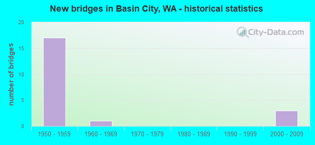
- New bridges - historical statistics
- 171950-1959
- 11960-1969
- 32000-2009

- Reconstructed bridges - Historical Statistics
- 51960-1969
- 11970-1979
- 01980-1989
- 01990-1999
- 12000-2009


- Bridge Condition - Deck
- 19.0%Very good
- 61.9%Good
- 14.3%Satisfactory
- 4.8%Fair

- Bridge Condition - Superstructure
- 23.8%Very good
- 57.1%Good
- 9.5%Satisfactory
- 4.8%Fair
- 4.8%Poor

- Bridge Condition - Substructure
- 33.3%Very good
- 66.7%Good

- Bridge Condition - Channel
- 95.0%Very good
- 5.0%Good
Find on map >> Show street view
Structure Number: 11PECL0109, Location: Block 19, PE. 46AWW Stati (Lat: 46.515903, Lng: -119.195392), Route carried "on" structure: ServiceOther road , Year Built: 1955, Year Reconstructed: 2009, Status: Posted for load, Structure Length: 0.88m (2.89ft), Average Daily Traffic: 10 (year 2021), Average Future Daily Traffic: 10 (year 2041), Design Load: H 10, Features Intersected: Potholes East Canal Late, Facility Carried by Structure: FARM ACCESS
Minimum Vertical Clearance: 30+ m (98+ ft), Kilometerpoint: 0.000, Lanes on structure: 1, Owner: Bureau of Reclamation, Maintenance Responsibility: Local Agency, Approaching Roadway Width: 4.9m (16.1ft), Material/Design: Wood or Timber, Design/Construction: Stringer/Multi-beam, Number Of Spans In Main Unit: 1, Length of Maximum Span: 8.1m (26.6ft), Curb or Sidewalk Widths: Left: 0.2m (0.7ft), Right: 0.2m (0.7ft), Curb-To-Curb Width: 4.5m (14.8ft), Out-to-Out Width: 4.9m (16.1ft)
Condition: Deck: Fair, Superstructure: Good, Substructure: Very good, Channel: Very good, Operating Rating: 28.0 metric tons, Method Used To Determine Operating Rating: Allowable Stress (AS), Inventory Rating: 20.2 metric tons, Method Used To Determine Inventory Rating: Allowable Stress (AS), Structural Evaluation: Somewhat better than minimum adequacy, Deck Geometry: Equal to present minimum criteria, Waterway Adequacy: Superior to present desirable criteria, Approach Roadway Alignment: Equal to present minimum criteria, Bridge Posting: Required (Relationship of Operating Rating to Maximum Legal Load: 0.1 - 9.9% below), Designated Inspection Frequency: Every 24 months, Inspection Date: March 2021, Deck Structure Type: Wood or Timber
Find on map >> Show street view
Structure Number: 7991, Location: 0.63W JCT R 901 (Lat: 46.547825, Lng: -119.145642), Route carried "on" structure: County highway 6700, Year Built: 1958, Status: Open, Structure Length: 1.10m (3.61ft), Average Daily Traffic: 230 (year 2018), Truck Traffic: 5%, Average Future Daily Traffic: 550 (year 2038), Design Load: H 15, Features Intersected: POTHOLES EAST CANAL, Facility Carried by Structure: COUNTY ARTERIAL
Minimum Vertical Clearance: 30+ m (98+ ft), Kilometerpoint: 0.001, Lanes on structure: 2, Owner: County Highway Agency, Approaching Roadway Width: 8.2m (26.9ft), Material/Design: Wood or Timber, Design/Construction: Stringer/Multi-beam, Number Of Spans In Main Unit: 2, Length of Maximum Span: 5.5m (18.0ft), Curb-To-Curb Width: 7.2m (23.6ft), Out-to-Out Width: 7.6m (24.9ft)
Condition: Deck: Good, Superstructure: Satisfactory, Substructure: Good, Channel: Very good, Operating Rating: 23.0 metric tons, Method Used To Determine Operating Rating: Allowable Stress (AS) rating reported by rating factor (RF) method using MS18 loading, Inventory Rating: 17.2 metric tons, Method Used To Determine Inventory Rating: Allowable Stress (AS) rating reported by rating factor (RF) method using MS18 loading, Structural Evaluation: Somewhat better than minimum adequacy, Deck Geometry: Meets minimum limits, Waterway Adequacy: Equal to present desirable criteria, Approach Roadway Alignment: Equal to present desirable criteria, Length Of Structure Improvement: 1.40m (4.59ft), Designated Inspection Frequency: Every 24 months, Inspection Date: December 2020, Bridge Improvement Cost: $699,000, Roadway Improvement Cost: $140,000, Total Project Cost: $1,398,000 ( Estimate for 2014), Deck Structure Type: Wood or Timber, Wearing Surface/Protective System: Wearing Surface: Bituminous
Find on map >> Show street view
Structure Number: 80048, Location: 0.01 S FERN RD 438 (Lat: 46.647281, Lng: -119.176789), Route carried "on" structure: County highway 4000, Year Built: 1957, Year Reconstructed: 1972, Status: Open, Structure Length: 0.98m (3.22ft), Average Daily Traffic: 2,710 (year 2018), Truck Traffic: 39%, Average Future Daily Traffic: 3,100 (year 2038), Design Load: HS 20, Features Intersected: W B 5, Facility Carried by Structure: COUNTY ARTERIAL
Minimum Vertical Clearance: 30+ m (98+ ft), Kilometerpoint: 0.001, Lanes on structure: 2, Owner: County Highway Agency, Approaching Roadway Width: 8.5m (27.9ft), Material/Design: Prestressed concrete, Design/Construction: Tee Beam, Number Of Spans In Main Unit: 1, Length of Maximum Span: 9.8m (32.2ft), Curb-To-Curb Width: 9.0m (29.5ft), Out-to-Out Width: 9.1m (29.9ft)
Condition: Deck: Very good, Superstructure: Very good, Substructure: Very good, Channel: Very good, Operating Rating: 45.4 metric tons, Method Used To Determine Operating Rating: Load Factor (LF), Inventory Rating: 28.1 metric tons, Method Used To Determine Inventory Rating: Load Factor (LF), Structural Evaluation: Better than present minimum criteria, Deck Geometry: Meets minimum limits, Waterway Adequacy: Equal to present desirable criteria, Approach Roadway Alignment: Equal to present desirable criteria, Length Of Structure Improvement: 1.28m (4.20ft), Designated Inspection Frequency: Every 24 months, Inspection Date: December 2021, Bridge Improvement Cost: $638,000, Roadway Improvement Cost: $128,000, Total Project Cost: $1,277,000 ( Estimate for 2014), Deck Structure Type: Other, Wearing Surface/Protective System: Wearing Surface: Monolithic Concrete
Find on map >> Show street view
Structure Number: 8028, Location: 0.14 S KLAMATH 686 (Lat: 46.560131, Lng: -119.090872), Route carried "on" structure: ServiceCounty highway 6690, Year Built: 1957, Status: Open, Structure Length: 0.94m (3.08ft), Average Daily Traffic: 24 (year 2020), Truck Traffic: 76%, Average Future Daily Traffic: 40 (year 2040), Design Load: H 15, Features Intersected: POTHOLES EAST CANAL, Facility Carried by Structure: COUNTY ROAD
Minimum Vertical Clearance: 30+ m (98+ ft), Kilometerpoint: 0.001, Lanes on structure: 2, Owner: County Highway Agency, Approaching Roadway Width: 7.3m (24.0ft), Material/Design: Wood or Timber, Design/Construction: Stringer/Multi-beam, Number Of Spans In Main Unit: 1, Length of Maximum Span: 9.4m (30.8ft), Curb-To-Curb Width: 7.3m (24.0ft), Out-to-Out Width: 7.6m (24.9ft)
Condition: Deck: Satisfactory, Superstructure: Good, Substructure: Good, Channel: Very good, Operating Rating: 34.5 metric tons, Method Used To Determine Operating Rating: Allowable Stress (AS), Inventory Rating: 23.6 metric tons, Method Used To Determine Inventory Rating: Allowable Stress (AS), Structural Evaluation: Equal to present minimum criteria, Deck Geometry: Equal to present minimum criteria, Waterway Adequacy: Equal to present desirable criteria, Approach Roadway Alignment: Equal to present desirable criteria, Length Of Structure Improvement: 1.25m (4.10ft), Designated Inspection Frequency: Every 24 months, Inspection Date: December 2021, Bridge Improvement Cost: $623,000, Roadway Improvement Cost: $125,000, Total Project Cost: $1,246,000 ( Estimate for 2014), Deck Structure Type: Wood or Timber, Wearing Surface/Protective System: Wearing Surface: Bituminous
Find on map >> Show street view
Structure Number: 80324, Location: 0.02 S FERN 438 (Lat: 46.640608, Lng: -119.201675), Route carried "on" structure: ServiceCounty highway 4470, Year Built: 1959, Status: Posted for load, Structure Length: 1.22m (4.00ft), Average Daily Traffic: 52 (year 2019), Truck Traffic: 10%, Average Future Daily Traffic: 120 (year 2039), Design Load: HS 20, Features Intersected: W B 5 GG, Facility Carried by Structure: COUNTY ROAD
Minimum Vertical Clearance: 30+ m (98+ ft), Kilometerpoint: 0.001, Lanes on structure: 2, Owner: County Highway Agency, Approaching Roadway Width: 7.9m (25.9ft), Material/Design: Wood or Timber, Design/Construction: Stringer/Multi-beam, Number Of Spans In Main Unit: 2, Length of Maximum Span: 6.1m (20.0ft), Curb-To-Curb Width: 7.3m (24.0ft), Out-to-Out Width: 7.6m (24.9ft)
Condition: Deck: Good, Superstructure: Satisfactory, Substructure: Good, Channel: Very good, Operating Rating: 22.4 metric tons, Method Used To Determine Operating Rating: Allowable Stress (AS) rating reported by rating factor (RF) method using MS18 loading, Inventory Rating: 16.8 metric tons, Method Used To Determine Inventory Rating: Allowable Stress (AS) rating reported by rating factor (RF) method using MS18 loading, Structural Evaluation: Somewhat better than minimum adequacy, Deck Geometry: Equal to present minimum criteria, Waterway Adequacy: Equal to present desirable criteria, Approach Roadway Alignment: Equal to present desirable criteria, Bridge Posting: Required (Relationship of Operating Rating to Maximum Legal Load: 10.0 - 19.9% below), Length Of Structure Improvement: 1.52m (4.99ft), Designated Inspection Frequency: Every 24 months, Inspection Date: December 2021, Bridge Improvement Cost: $760,000, Roadway Improvement Cost: $152,000, Total Project Cost: $1,520,000 ( Estimate for 2014), Deck Structure Type: Wood or Timber, Wearing Surface/Protective System: Wearing Surface: Gravel
Find on map >> Show street view
Structure Number: 80379, Location: 0.74E JCT R 507 (Lat: 46.548628, Lng: -119.216047), Route carried "on" structure: County highway 6700, Year Built: 1958, Status: Posted for load, Structure Length: 1.43m (4.69ft), Average Daily Traffic: 230 (year 2018), Truck Traffic: 15%, Average Future Daily Traffic: 530 (year 2038), Design Load: H 15, Features Intersected: P-E-41-2-C, Facility Carried by Structure: COUNTY ARTERIAL
Minimum Vertical Clearance: 30+ m (98+ ft), Kilometerpoint: 0.001, Lanes on structure: 2, Owner: County Highway Agency, Approaching Roadway Width: 7.9m (25.9ft), Skew: 3 degrees, Material/Design: Wood or Timber, Design/Construction: Stringer/Multi-beam, Number Of Spans In Main Unit: 2, Length of Maximum Span: 7.3m (24.0ft), Curb-To-Curb Width: 7.3m (24.0ft), Out-to-Out Width: 7.6m (24.9ft)
Condition: Deck: Good, Superstructure: Good, Substructure: Good, Channel: Very good, Operating Rating: 22.4 metric tons, Method Used To Determine Operating Rating: Allowable Stress (AS) rating reported by rating factor (RF) method using MS18 loading, Inventory Rating: 16.8 metric tons, Method Used To Determine Inventory Rating: Allowable Stress (AS) rating reported by rating factor (RF) method using MS18 loading, Structural Evaluation: Somewhat better than minimum adequacy, Deck Geometry: Somewhat better than minimum adequacy, Waterway Adequacy: Equal to present desirable criteria, Approach Roadway Alignment: Equal to present desirable criteria, Bridge Posting: Required (Relationship of Operating Rating to Maximum Legal Load: 30.0 - 39.9% below), Length Of Structure Improvement: 1.74m (5.71ft), Designated Inspection Frequency: Every 24 months, Inspection Date: December 2020, Bridge Improvement Cost: $866,000, Roadway Improvement Cost: $173,000, Total Project Cost: $1,733,000 ( Estimate for 2014), Deck Structure Type: Wood or Timber, Wearing Surface/Protective System: Wearing Surface: Bituminous
Find on map >> Show street view
Structure Number: 80503, Location: 1.35E JCT R 901 (Lat: 46.547200, Lng: -119.103842), Route carried "on" structure: County highway 6700, Year Built: 1956, Year Reconstructed: 1978, Status: Open, Structure Length: 0.79m (2.59ft), Average Daily Traffic: 365 (year 2018), Truck Traffic: 5%, Average Future Daily Traffic: 510 (year 2038), Design Load: HS 20, Features Intersected: POTHOLES EAST CANAL, Facility Carried by Structure: COUNTY ARTERIAL
Minimum Vertical Clearance: 30+ m (98+ ft), Kilometerpoint: 0.001, Lanes on structure: 2, Owner: County Highway Agency, Approaching Roadway Width: 7.9m (25.9ft), Skew: 1 degrees, Material/Design: Prestressed concrete, Design/Construction: Stringer/Multi-beam, Number Of Spans In Main Unit: 1, Length of Maximum Span: 7.9m (25.9ft), Curb-To-Curb Width: 9.0m (29.5ft), Out-to-Out Width: 9.1m (29.9ft)
Condition: Deck: Good, Superstructure: Very good, Substructure: Good, Channel: Very good, Operating Rating: 39.0 metric tons, Method Used To Determine Operating Rating: Allowable Stress (AS), Inventory Rating: 30.8 metric tons, Method Used To Determine Inventory Rating: Allowable Stress (AS), Structural Evaluation: Better than present minimum criteria, Deck Geometry: Equal to present minimum criteria, Waterway Adequacy: Equal to present desirable criteria, Approach Roadway Alignment: Equal to present desirable criteria, Length Of Structure Improvement: 1.10m (3.61ft), Designated Inspection Frequency: Every 24 months, Inspection Date: December 2020, Bridge Improvement Cost: $547,000, Roadway Improvement Cost: $109,000, Total Project Cost: $1,094,000 ( Estimate for 2014), Deck Structure Type: Other, Wearing Surface/Protective System: Wearing Surface: Bituminous
Find on map >> Show street view
Structure Number: 80601, Location: 0.85EJCT R 507 (Lat: 46.534217, Lng: -119.219358), Route carried "on" structure: Spur County highway 5540, Year Built: 1956, Status: Open, Structure Length: 1.07m (3.51ft), Average Daily Traffic: 52 (year 2018), Truck Traffic: 5%, Average Future Daily Traffic: 110 (year 2038), Design Load: HS 20, Features Intersected: P-E-41-2-H, Facility Carried by Structure: COUNTY ROAD
Minimum Vertical Clearance: 30+ m (98+ ft), Kilometerpoint: 0.001, Lanes on structure: 2, Owner: County Highway Agency, Approaching Roadway Width: 7.3m (24.0ft), Material/Design: Wood or Timber, Design/Construction: Stringer/Multi-beam, Number Of Spans In Main Unit: 2, Length of Maximum Span: 5.5m (18.0ft), Curb-To-Curb Width: 7.1m (23.3ft), Out-to-Out Width: 7.6m (24.9ft)
Condition: Deck: Good, Superstructure: Good, Substructure: Good, Channel: Good, Operating Rating: 45.4 metric tons, Method Used To Determine Operating Rating: Allowable Stress (AS), Inventory Rating: 32.7 metric tons, Method Used To Determine Inventory Rating: Allowable Stress (AS), Structural Evaluation: Better than present minimum criteria, Deck Geometry: Somewhat better than minimum adequacy, Waterway Adequacy: Equal to present desirable criteria, Approach Roadway Alignment: Equal to present minimum criteria, Length Of Structure Improvement: 1.37m (4.49ft), Designated Inspection Frequency: Every 24 months, Inspection Date: December 2020, Bridge Improvement Cost: $684,000, Roadway Improvement Cost: $137,000, Total Project Cost: $1,368,000 ( Estimate for 2014), Deck Structure Type: Wood or Timber, Wearing Surface/Protective System: Wearing Surface: Gravel
Find on map >> Show street view
Structure Number: 81083, Location: 0.68 SW PALMER 541 (Lat: 46.533625, Lng: -119.167864), Route carried "on" structure: ServiceCounty highway 5390, Year Built: 1958, Status: Posted for load, Structure Length: 1.37m (4.49ft), Average Daily Traffic: 201 (year 2018), Truck Traffic: 10%, Average Future Daily Traffic: 155 (year 2038), Design Load: H 15, Features Intersected: P E 46 A W W, Facility Carried by Structure: COUNTY ROAD
Minimum Vertical Clearance: 30+ m (98+ ft), Kilometerpoint: 0.001, Lanes on structure: 2, Owner: County Highway Agency, Approaching Roadway Width: 6.7m (22.0ft), Skew: 4 degrees, Material/Design: Wood or Timber, Design/Construction: Stringer/Multi-beam, Number Of Spans In Main Unit: 2, Length of Maximum Span: 7.0m (23.0ft), Curb-To-Curb Width: 7.3m (24.0ft), Out-to-Out Width: 7.6m (24.9ft)
Condition: Deck: Good, Superstructure: Good, Substructure: Very good, Channel: Very good, Operating Rating: 21.1 metric tons, Method Used To Determine Operating Rating: Allowable Stress (AS) rating reported by rating factor (RF) method using MS18 loading, Inventory Rating: 14.6 metric tons, Method Used To Determine Inventory Rating: Allowable Stress (AS) rating reported by rating factor (RF) method using MS18 loading, Structural Evaluation: Meets minimum limits, Deck Geometry: Somewhat better than minimum adequacy, Waterway Adequacy: Equal to present desirable criteria, Approach Roadway Alignment: Equal to present desirable criteria, Bridge Posting: Required (Relationship of Operating Rating to Maximum Legal Load: > 39.9% below), Length Of Structure Improvement: 1.68m (5.51ft), Designated Inspection Frequency: Every 24 months, Inspection Date: December 2020, Bridge Improvement Cost: $836,000, Roadway Improvement Cost: $167,000, Total Project Cost: $1,672,000 ( Estimate for 2014), Deck Structure Type: Wood or Timber, Wearing Surface/Protective System: Wearing Surface: Bituminous
Find on map >> Show street view
Structure Number: 81341, Location: 3.69S JCT R 608 (Lat: 46.537842, Lng: -119.132167), Route carried "on" structure: County highway 9010, Year Built: 1954, Year Reconstructed: 1972, Status: Open, Structure Length: 2.96m (9.71ft), Average Daily Traffic: 2,414 (year 2018), Truck Traffic: 35%, Average Future Daily Traffic: 2,560 (year 2038), Design Load: HS 20, Features Intersected: POTHOLES EAST CANAL, Facility Carried by Structure: COUNTY HIGHWAY
Minimum Vertical Clearance: 30+ m (98+ ft), Kilometerpoint: 0.001, Lanes on structure: 2, Owner: County Highway Agency, Approaching Roadway Width: 8.8m (28.9ft), Skew: 1 degrees, Material/Design: Prestressed concrete, Design/Construction: Tee Beam, Number Of Spans In Main Unit: 4, Length of Maximum Span: 8.8m (28.9ft), Curb-To-Curb Width: 8.9m (29.2ft), Out-to-Out Width: 9.4m (30.8ft)
Condition: Deck: Good, Superstructure: Good, Substructure: Good, Channel: Very good, Operating Rating: 45.4 metric tons, Method Used To Determine Operating Rating: Allowable Stress (AS), Inventory Rating: 32.7 metric tons, Method Used To Determine Inventory Rating: Allowable Stress (AS), Structural Evaluation: Better than present minimum criteria, Deck Geometry: Meets minimum limits, Waterway Adequacy: Equal to present desirable criteria, Approach Roadway Alignment: Equal to present desirable criteria, Length Of Structure Improvement: 3.26m (10.70ft), Designated Inspection Frequency: Every 24 months, Inspection Date: December 2020, Bridge Improvement Cost: $1,626,000, Roadway Improvement Cost: $325,000, Total Project Cost: $3,253,000 ( Estimate for 2014), Deck Structure Type: Concrete Precast Panels, Wearing Surface/Protective System: Wearing Surface: Bituminous
Find on map >> Show street view
Structure Number: 8146, Location: 0.49 S RUSSELL 670 (Lat: 46.539964, Lng: -119.111142), Route carried "on" structure: ServiceCounty highway 6150, Year Built: 1957, Status: Open, Structure Length: 0.82m (2.69ft), Average Daily Traffic: 158 (year 2019), Truck Traffic: 45%, Average Future Daily Traffic: 240 (year 2039), Design Load: H 15, Features Intersected: POTHOLES EAST CANAL, Facility Carried by Structure: COUNTY ROAD
Minimum Vertical Clearance: 30+ m (98+ ft), Kilometerpoint: 0.001, Lanes on structure: 2, Owner: County Highway Agency, Approaching Roadway Width: 7.3m (24.0ft), Material/Design: Wood or Timber, Design/Construction: Stringer/Multi-beam, Number Of Spans In Main Unit: 1, Length of Maximum Span: 8.2m (26.9ft), Curb-To-Curb Width: 7.3m (24.0ft), Out-to-Out Width: 7.6m (24.9ft)
Condition: Deck: Good, Superstructure: Good, Substructure: Good, Channel: Very good, Operating Rating: 39.0 metric tons, Method Used To Determine Operating Rating: Allowable Stress (AS), Inventory Rating: 27.2 metric tons, Method Used To Determine Inventory Rating: Allowable Stress (AS), Structural Evaluation: Equal to present minimum criteria, Deck Geometry: Somewhat better than minimum adequacy, Waterway Adequacy: Equal to present desirable criteria, Approach Roadway Alignment: Equal to present desirable criteria, Length Of Structure Improvement: 1.13m (3.71ft), Designated Inspection Frequency: Every 24 months, Inspection Date: December 2021, Bridge Improvement Cost: $562,000, Roadway Improvement Cost: $112,000, Total Project Cost: $1,125,000 ( Estimate for 2014), Deck Structure Type: Wood or Timber, Wearing Surface/Protective System: Wearing Surface: Bituminous
Find on map >> Show street view
Structure Number: 81787, Location: 0.84W JCT R 901 (Lat: 46.519647, Lng: -119.149619), Route carried "on" structure: ServiceCounty highway 6360, Year Built: 1958, Status: Posted for load, Structure Length: 2.50m (8.20ft), Average Daily Traffic: 172 (year 2018), Truck Traffic: 10%, Average Future Daily Traffic: 240 (year 2038), Design Load: H 15, Features Intersected: POTHOLES EAST CANAL, Facility Carried by Structure: COUNTY ROAD
Minimum Vertical Clearance: 30+ m (98+ ft), Kilometerpoint: 0.001, Lanes on structure: 2, Owner: County Highway Agency, Approaching Roadway Width: 7.9m (25.9ft), Material/Design: Wood or Timber, Design/Construction: Stringer/Multi-beam, Number Of Spans In Main Unit: 3, Length of Maximum Span: 8.5m (27.9ft), Curb-To-Curb Width: 7.3m (24.0ft), Out-to-Out Width: 7.6m (24.9ft)
Condition: Deck: Good, Superstructure: Poor, Substructure: Good, Channel: Very good, Operating Rating: 21.4 metric tons, Method Used To Determine Operating Rating: Allowable Stress (AS) rating reported by rating factor (RF) method using MS18 loading, Inventory Rating: 13.0 metric tons, Method Used To Determine Inventory Rating: Allowable Stress (AS) rating reported by rating factor (RF) method using MS18 loading, Structural Evaluation: Meets minimum limits, Deck Geometry: Somewhat better than minimum adequacy, Waterway Adequacy: Equal to present desirable criteria, Approach Roadway Alignment: Equal to present desirable criteria, Bridge Posting: Required (Relationship of Operating Rating to Maximum Legal Load: > 39.9% below), Length Of Structure Improvement: 2.80m (9.19ft), Designated Inspection Frequency: Every 24 months, Inspection Date: December 2020, Bridge Improvement Cost: $1,398,000, Roadway Improvement Cost: $280,000, Total Project Cost: $2,797,000 ( Estimate for 2014), Deck Structure Type: Wood or Timber, Wearing Surface/Protective System: Wearing Surface: Bituminous
Find on map >> Show street view
Structure Number: 82107, Location: 2.67 W GLADE N 901 (Lat: 46.519639, Lng: -119.187583), Route carried "on" structure: ServiceCounty highway 6360, Year Built: 1958, Status: Posted for load, Structure Length: 0.85m (2.79ft), Average Daily Traffic: 120 (year 2018), Truck Traffic: 5%, Average Future Daily Traffic: 250 (year 2038), Design Load: H 15, Features Intersected: POTHOLES EAST CANAL, Facility Carried by Structure: COUNTY ROAD
Minimum Vertical Clearance: 30+ m (98+ ft), Kilometerpoint: 0.001, Lanes on structure: 2, Owner: County Highway Agency, Approaching Roadway Width: 7.3m (24.0ft), Skew: 3 degrees, Material/Design: Wood or Timber, Design/Construction: Stringer/Multi-beam, Number Of Spans In Main Unit: 1, Length of Maximum Span: 8.2m (26.9ft), Curb-To-Curb Width: 7.2m (23.6ft), Out-to-Out Width: 7.6m (24.9ft)
Condition: Deck: Good, Superstructure: Good, Substructure: Very good, Channel: Very good, Operating Rating: 25.6 metric tons, Method Used To Determine Operating Rating: Allowable Stress (AS) rating reported by rating factor (RF) method using MS18 loading, Inventory Rating: 17.2 metric tons, Method Used To Determine Inventory Rating: Allowable Stress (AS) rating reported by rating factor (RF) method using MS18 loading, Structural Evaluation: Somewhat better than minimum adequacy, Deck Geometry: Meets minimum limits, Waterway Adequacy: Equal to present desirable criteria, Approach Roadway Alignment: Equal to present desirable criteria, Bridge Posting: Required (Relationship of Operating Rating to Maximum Legal Load: 30.0 - 39.9% below), Length Of Structure Improvement: 1.16m (3.81ft), Designated Inspection Frequency: Every 24 months, Inspection Date: December 2020, Bridge Improvement Cost: $578,000, Roadway Improvement Cost: $116,000, Total Project Cost: $1,155,000 ( Estimate for 2014), Deck Structure Type: Wood or Timber, Wearing Surface/Protective System: Wearing Surface: Bituminous
Find on map >> Show street view
Structure Number: 83032, Location: 0.07E SAGEHILL 400 (Lat: 46.591203, Lng: -119.174950), Route carried "on" structure: County highway 6080, Year Built: 1956, Year Reconstructed: 1974, Status: Open, Structure Length: 1.55m (5.09ft), Average Daily Traffic: 2,181 (year 2018), Truck Traffic: 22%, Average Future Daily Traffic: 3,270 (year 2038), Design Load: HS 20, Features Intersected: POTHOLES CANAL, Facility Carried by Structure: COUNTY HIGHWAY
Minimum Vertical Clearance: 30+ m (98+ ft), Kilometerpoint: 0.001, Lanes on structure: 2, Owner: County Highway Agency, Approaching Roadway Width: 8.5m (27.9ft), Material/Design: Prestressed concrete, Design/Construction: Tee Beam, Number Of Spans In Main Unit: 2, Length of Maximum Span: 7.9m (25.9ft), Curb-To-Curb Width: 9.6m (31.5ft), Out-to-Out Width: 9.8m (32.2ft)
Condition: Deck: Satisfactory, Superstructure: Fair, Substructure: Good, Channel: Very good, Operating Rating: 47.2 metric tons, Method Used To Determine Operating Rating: Load Factor (LF), Inventory Rating: 24.5 metric tons, Method Used To Determine Inventory Rating: Load Factor (LF), Structural Evaluation: Somewhat better than minimum adequacy, Deck Geometry: Meets minimum limits, Waterway Adequacy: Equal to present desirable criteria, Approach Roadway Alignment: Equal to present desirable criteria, Length Of Structure Improvement: 1.86m (6.10ft), Designated Inspection Frequency: Every 24 months, Inspection Date: December 2021, Bridge Improvement Cost: $927,000, Roadway Improvement Cost: $185,000, Total Project Cost: $1,854,000 ( Estimate for 2014), Deck Structure Type: Other, Wearing Surface/Protective System: Wearing Surface: Bituminous
Find on map >> Show street view
Structure Number: 83707, Location: 0.8 E SAGEHILL 400 (Lat: 46.670842, Lng: -119.161725), Route carried "on" structure: County highway 3700, Year Built: 1953, Year Reconstructed: 1974, Status: Open, Structure Length: 0.98m (3.22ft), Average Daily Traffic: 370 (year 2019), Truck Traffic: 10%, Average Future Daily Traffic: 560 (year 2039), Design Load: HS 20, Features Intersected: SCOOTENEY RESEVOIR, Facility Carried by Structure: COUNTY HIGHWAY
Minimum Vertical Clearance: 30+ m (98+ ft), Kilometerpoint: 0.001, Lanes on structure: 2, Owner: County Highway Agency, Approaching Roadway Width: 7.3m (24.0ft), Skew: 1 degrees, Material/Design: Prestressed concrete, Design/Construction: Stringer/Multi-beam, Number Of Spans In Main Unit: 1, Length of Maximum Span: 9.8m (32.2ft), Curb-To-Curb Width: 7.9m (25.9ft), Out-to-Out Width: 8.5m (27.9ft)
Condition: Deck: Satisfactory, Superstructure: Good, Substructure: Good, Channel: Very good, Operating Rating: 38.6 metric tons, Method Used To Determine Operating Rating: Load and Resistance Factor Rating (LRFR) rating reported by rating factor(RF) method using HL-93 loadings, Inventory Rating: 18.8 metric tons, Method Used To Determine Inventory Rating: Load and Resistance Factor Rating (LRFR) rating reported by rating factor(RF) method using HL-93 loadings, Structural Evaluation: Somewhat better than minimum adequacy, Deck Geometry: Somewhat better than minimum adequacy, Waterway Adequacy: Equal to present desirable criteria, Approach Roadway Alignment: Equal to present desirable criteria, Bridge Posting: Required (Relationship of Operating Rating to Maximum Legal Load: 20.0 - 29.9% below), Length Of Structure Improvement: 1.28m (4.20ft), Designated Inspection Frequency: Every 24 months, Inspection Date: December 2021, Bridge Improvement Cost: $638,000, Roadway Improvement Cost: $128,000, Total Project Cost: $1,277,000 ( Estimate for 2014), Deck Structure Type: Other, Wearing Surface/Protective System: Wearing Surface: Bituminous
Find on map >> Show street view
Structure Number: 83845, Location: 0.31 W R-170 608 (Lat: 46.576667, Lng: -119.188611), Route carried "on" structure: ServiceCounty highway 6900, Year Built: 1956, Status: Posted for load, Structure Length: 1.31m (4.30ft), Average Daily Traffic: 34 (year 2020), Truck Traffic: 37%, Average Future Daily Traffic: 50 (year 2040), Design Load: H 15, Features Intersected: P-E-41-2-C, Facility Carried by Structure: COUNTY ROAD
Minimum Vertical Clearance: 30+ m (98+ ft), Kilometerpoint: 0.001, Lanes on structure: 2, Owner: County Highway Agency, Approaching Roadway Width: 7.9m (25.9ft), Material/Design: Wood or Timber, Design/Construction: Stringer/Multi-beam, Number Of Spans In Main Unit: 2, Length of Maximum Span: 6.7m (22.0ft), Curb-To-Curb Width: 7.3m (24.0ft), Out-to-Out Width: 7.6m (24.9ft)
Condition: Deck: Good, Superstructure: Good, Substructure: Good, Channel: Very good, Operating Rating: 22.4 metric tons, Method Used To Determine Operating Rating: Allowable Stress (AS) rating reported by rating factor (RF) method using MS18 loading, Inventory Rating: 16.8 metric tons, Method Used To Determine Inventory Rating: Allowable Stress (AS) rating reported by rating factor (RF) method using MS18 loading, Structural Evaluation: Somewhat better than minimum adequacy, Deck Geometry: Equal to present minimum criteria, Waterway Adequacy: Equal to present desirable criteria, Approach Roadway Alignment: Equal to present desirable criteria, Bridge Posting: Required (Relationship of Operating Rating to Maximum Legal Load: 10.0 - 19.9% below), Length Of Structure Improvement: 1.62m (5.31ft), Designated Inspection Frequency: Every 24 months, Inspection Date: December 2021, Bridge Improvement Cost: $806,000, Roadway Improvement Cost: $161,000, Total Project Cost: $1,611,000 ( Estimate for 2014), Deck Structure Type: Wood or Timber, Wearing Surface/Protective System: Wearing Surface: Bituminous
Find on map >> Show street view
Structure Number: 84104, Location: 0.08E COLONIAL 669 (Lat: 46.576764, Lng: -119.093167), Route carried "on" structure: ServiceCounty highway 6900, Year Built: 1956, Year Reconstructed: 1973, Status: Open, Structure Length: 2.59m (8.50ft), Average Daily Traffic: 474 (year 2020), Truck Traffic: 46%, Average Future Daily Traffic: 710 (year 2040), Design Load: HS 20, Features Intersected: POTHOLES EAST CANAL, Facility Carried by Structure: COUNTY HIGHWAY
Minimum Vertical Clearance: 30+ m (98+ ft), Kilometerpoint: 0.001, Lanes on structure: 2, Owner: County Highway Agency, Approaching Roadway Width: 7.6m (24.9ft), Material/Design: Prestressed concrete, Design/Construction: Stringer/Multi-beam, Number Of Spans In Main Unit: 3, Length of Maximum Span: 9.1m (29.9ft), Curb-To-Curb Width: 8.4m (27.6ft), Out-to-Out Width: 8.5m (27.9ft)
Condition: Deck: Good, Superstructure: Good, Substructure: Good, Channel: Very good, Operating Rating: 39.9 metric tons, Method Used To Determine Operating Rating: Load Factor (LF), Inventory Rating: 20.0 metric tons, Method Used To Determine Inventory Rating: Load Factor (LF), Structural Evaluation: Somewhat better than minimum adequacy, Deck Geometry: Somewhat better than minimum adequacy, Waterway Adequacy: Equal to present desirable criteria, Approach Roadway Alignment: Equal to present desirable criteria, Length Of Structure Improvement: 2.90m (9.51ft), Designated Inspection Frequency: Every 24 months, Inspection Date: December 2021, Bridge Improvement Cost: $1,444,000, Roadway Improvement Cost: $289,000, Total Project Cost: $2,888,000 ( Estimate for 2014), Deck Structure Type: Other, Wearing Surface/Protective System: Wearing Surface: Monolithic Concrete
Find on map >> Show street view
Structure Number: 84111, Location: 0.69 E GLADE N 901 (Lat: 46.576781, Lng: -119.108067), Route carried "on" structure: County highway 6900, Year Built: 1969, Status: Open, Structure Length: 4.60m (15.09ft), Average Daily Traffic: 507 (year 2020), Truck Traffic: 28%, Average Future Daily Traffic: 753 (year 2040), Design Load: HS 20, Features Intersected: OLD RAILROAD BED, Facility Carried by Structure: SHEFFIELD ROAD
Minimum Vertical Clearance: 30+ m (98+ ft), Kilometerpoint: 0.001, Lanes on structure: 2, Owner: County Highway Agency, Approaching Roadway Width: 8.2m (26.9ft), Skew: 3 degrees, Material/Design: Steel, Design/Construction: Girder and Floorbeam System, Number Of Spans In Main Unit: 3, Length of Maximum Span: 18.3m (60.0ft), Curb or Sidewalk Widths: Left: 0.6m (2.0ft), Right: 0.6m (2.0ft), Curb-To-Curb Width: 8.6m (28.2ft), Out-to-Out Width: 9.8m (32.2ft)
Condition: Deck: Good, Superstructure: Good, Substructure: Good, Operating Rating: 52.6 metric tons, Method Used To Determine Operating Rating: Load Factor (LF), Inventory Rating: 30.8 metric tons, Method Used To Determine Inventory Rating: Load Factor (LF), Structural Evaluation: Better than present minimum criteria, Deck Geometry: Somewhat better than minimum adequacy, Approach Roadway Alignment: Equal to present desirable criteria, Length Of Structure Improvement: 4.91m (16.11ft), Designated Inspection Frequency: Every 24 months, Inspection Date: November 2020, Bridge Improvement Cost: $2,447,000, Roadway Improvement Cost: $489,000, Total Project Cost: $4,894,000 ( Estimate for 2014), Deck Structure Type: Concrete Cast-file-Place, Wearing Surface/Protective System: Wearing Surface: Monolithic Concrete
Find on map >> Show street view
Structure Number: 87034, Location: 0.44 E GLADE N 901 (Lat: 46.547428, Lng: -119.122817), Route carried "on" structure: County highway 6700, Year Built: 2003, Status: Open, Structure Length: 3.14m (10.30ft), Average Daily Traffic: 361 (year 2018), Truck Traffic: 5%, Average Future Daily Traffic: 450 (year 2038), Design Load: HL 93, Features Intersected: POTHOLES CANAL, Facility Carried by Structure: COUNTY ARTERIAL
Minimum Vertical Clearance: 30+ m (98+ ft), Kilometerpoint: 0.001, Lanes on structure: 2, Owner: County Highway Agency, Approaching Roadway Width: 8.5m (27.9ft), Skew: 2 degrees, Material/Design: Prestressed concrete, Design/Construction: Tee Beam, Number Of Spans In Main Unit: 1, Length of Maximum Span: 31.4m (103.0ft), Curb-To-Curb Width: 8.7m (28.5ft), Out-to-Out Width: 8.9m (29.2ft)
Condition: Deck: Very good, Superstructure: Very good, Substructure: Very good, Channel: Very good, Operating Rating: 89.8 metric tons, Method Used To Determine Operating Rating: Load and Resistance Factor (LRFR), Inventory Rating: 63.5 metric tons, Method Used To Determine Inventory Rating: Load and Resistance Factor (LRFR), Structural Evaluation: Equal to present desirable criteria, Deck Geometry: Equal to present minimum criteria, Waterway Adequacy: Equal to present desirable criteria, Approach Roadway Alignment: Equal to present desirable criteria, Designated Inspection Frequency: Every 24 months, Inspection Date: December 2020, Deck Structure Type: Other, Wearing Surface/Protective System: Wearing Surface: Monolithic Concrete
Find on map >> Show street view
Structure Number: 87035, Location: 1.51 W GLADE N 01 (Lat: 46.519772, Lng: -119.163531), Route carried "on" structure: County highway 6360, Year Built: 2003, Status: Open, Structure Length: 3.35m (10.99ft), Average Daily Traffic: 120 (year 2018), Truck Traffic: 10%, Average Future Daily Traffic: 240 (year 2038), Design Load: HL 93, Features Intersected: POTHOLES CANAL, Facility Carried by Structure: COUNTY ROAD
Minimum Vertical Clearance: 30+ m (98+ ft), Kilometerpoint: 0.001, Lanes on structure: 2, Owner: County Highway Agency, Approaching Roadway Width: 8.5m (27.9ft), Skew: 2 degrees, Material/Design: Prestressed concrete, Design/Construction: Tee Beam, Number Of Spans In Main Unit: 1, Length of Maximum Span: 33.5m (109.9ft), Curb-To-Curb Width: 8.7m (28.5ft), Out-to-Out Width: 8.9m (29.2ft)
Condition: Deck: Very good, Superstructure: Very good, Substructure: Very good, Channel: Very good, Operating Rating: 89.8 metric tons, Method Used To Determine Operating Rating: Load and Resistance Factor (LRFR), Inventory Rating: 64.4 metric tons, Method Used To Determine Inventory Rating: Load and Resistance Factor (LRFR), Structural Evaluation: Equal to present desirable criteria, Deck Geometry: Equal to present minimum criteria, Waterway Adequacy: Equal to present desirable criteria, Approach Roadway Alignment: Equal to present desirable criteria, Designated Inspection Frequency: Every 24 months, Inspection Date: December 2020, Deck Structure Type: Other, Wearing Surface/Protective System: Wearing Surface: Monolithic Concrete
Find on map >> Show street view
Structure Number: 87227, Location: 0.11N H. SPUR 476 (Lat: 46.622328, Lng: -119.218539), Route carried "on" structure: County highway 4050, Year Built: 2005, Status: Open, Structure Length: 1.43m (4.69ft), Average Daily Traffic: 164 (year 2020), Truck Traffic: 36%, Average Future Daily Traffic: 259 (year 2040), Design Load: HL 93, Features Intersected: W B 5 W W 1, Facility Carried by Structure: COUNTY ARTERIAL
Minimum Vertical Clearance: 30+ m (98+ ft), Kilometerpoint: 0.001, Lanes on structure: 2, Owner: County Highway Agency, Approaching Roadway Width: 8.5m (27.9ft), Skew: 3 degrees, Material/Design: Prestressed concrete, Design/Construction: Tee Beam, Number Of Spans In Main Unit: 1, Length of Maximum Span: 13.4m (44.0ft), Curb-To-Curb Width: 8.5m (27.9ft), Out-to-Out Width: 8.8m (28.9ft)
Condition: Deck: Very good, Superstructure: Very good, Substructure: Very good, Channel: Very good, Operating Rating: 74.4 metric tons, Method Used To Determine Operating Rating: Load Factor (LF), Inventory Rating: 44.4 metric tons, Method Used To Determine Inventory Rating: Load Factor (LF), Structural Evaluation: Equal to present desirable criteria, Deck Geometry: Equal to present minimum criteria, Waterway Adequacy: Equal to present desirable criteria, Approach Roadway Alignment: Equal to present desirable criteria, Designated Inspection Frequency: Every 24 months, Inspection Date: November 2020, Deck Structure Type: Other, Wearing Surface/Protective System: Wearing Surface: Monolithic Concrete