Bridge Statistics for Bartow, Florida (FL)
Condition, Traffic, Stress, Structural Evaluation, Project Costs
- National Bridge Inventory (NBI) Statistics
- 27Number of bridges
- 318ft / 96.7mTotal length
- $144,000Total costs
- 297,000Total average daily traffic
- 50,925Total average daily truck traffic
- National Bridge Inventory (NBI) Registered Bridges for Bartow
- No street view available for this location
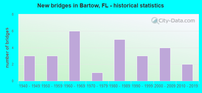
- New bridges - historical statistics
- 31940-1949
- 31950-1959
- 61960-1969
- 11970-1979
- 51980-1989
- 31990-1999
- 42000-2009
- 22010-2019

- Reconstructed bridges - Historical Statistics
- 21970-1979
- 31980-1989


- Bridge Condition - Deck
- 69.2%Good
- 30.8%Satisfactory

- Bridge Condition - Superstructure
- 15.4%Very good
- 69.2%Good
- 15.4%Satisfactory

- Bridge Condition - Substructure
- 23.1%Very good
- 69.2%Good
- 7.7%Satisfactory

- Bridge Condition - Channel
- 13.0%Excellent
- 13.0%Very good
- 47.8%Good
- 21.7%Satisfactory
- 4.3%Fair

- Bridge Condition - Culverts
- 8.3%Very good
- 50.0%Good
- 41.7%Satisfactory
Find on map >> Show street view
Structure Number: 60055, Location: 1.2MI. EAST OF US-17 (Lat: 27.550992, Lng: -81.791289), Route carried "on" structure: Alternate State highway 64A, Year Built: 1999, Status: Open, Structure Length: 3.91m (12.83ft), Average Daily Traffic: 6,700 (year 2020), Truck Traffic: 16%, Average Future Daily Traffic: 11,624 (year 2042), Design Load: HS 25 or greater, Features Intersected: PEACE RIVER RELIEF
Minimum Vertical Clearance: 30+ m (98+ ft), Kilometerpoint: 2.039, Lanes on structure: 2, Base Highway Network: Yes, Owner: State Highway Agency, Approaching Roadway Width: 10.2m (33.5ft), Material/Design: Concrete continuous, Design/Construction: Slab, Number Of Spans In Main Unit: 5, Length of Maximum Span: 8.5m (27.9ft), Curb-To-Curb Width: 13.2m (43.3ft), Out-to-Out Width: 14.1m (46.3ft)
Condition: Deck: Good, Superstructure: Good, Substructure: Very good, Channel: Good, Operating Rating: 63.3 metric tons, Method Used To Determine Operating Rating: Load Factor (LF), Inventory Rating: 38.0 metric tons, Method Used To Determine Inventory Rating: Load Factor (LF), Structural Evaluation: Better than present minimum criteria, Deck Geometry: Somewhat better than minimum adequacy, Waterway Adequacy: Superior to present desirable criteria, Approach Roadway Alignment: Equal to present desirable criteria, Designated Inspection Frequency: Every 24 months, Underwater Inspection Frequency: Every 23 months, Inspection Date: January 2022, Underwater Inspection Date: January 2022, Deck Structure Type: Concrete Cast-file-Place
Find on map >> Show street view
Structure Number: 60056, Location: 10.9MI. EAST OF US-17 (Lat: 27.565028, Lng: -81.637833), Route carried "on" structure: State highway 64, Year Built: 1999, Status: Open, Structure Length: 7.83m (25.69ft), Average Daily Traffic: 7,000 (year 2020), Truck Traffic: 24%, Average Future Daily Traffic: 12,145 (year 2042), Design Load: HS 20+Mod, Features Intersected: CHARLIE CREEK
Minimum Vertical Clearance: 30+ m (98+ ft), Kilometerpoint: 17.426, Lanes on structure: 2, Base Highway Network: Yes, Owner: State Highway Agency, Approaching Roadway Width: 13.3m (43.6ft), Material/Design: Prestressed concrete, Design/Construction: Stringer/Multi-beam, Number Of Spans In Main Unit: 5, Length of Maximum Span: 15.7m (51.5ft), Curb-To-Curb Width: 13.3m (43.6ft), Out-to-Out Width: 14.2m (46.6ft)
Condition: Deck: Good, Superstructure: Good, Substructure: Good, Channel: Excellent, Operating Rating: 66.0 metric tons, Method Used To Determine Operating Rating: Load Factor (LF), Inventory Rating: 39.5 metric tons, Method Used To Determine Inventory Rating: Load Factor (LF), Structural Evaluation: Better than present minimum criteria, Deck Geometry: Somewhat better than minimum adequacy, Waterway Adequacy: Superior to present desirable criteria, Approach Roadway Alignment: Equal to present desirable criteria, Designated Inspection Frequency: Every 24 months, Inspection Date: January 2022, Deck Structure Type: Concrete Cast-file-Place
Find on map >> Show street view
Structure Number: 160001, Location: 0.2 MI NORTH OF SR-60 (Lat: 27.906444, Lng: -81.843472), Route carried "on" structure: US 98, Year Built: 1960, Year Reconstructed: 1986, Status: Open, Structure Length: 0.98m (3.22ft), Average Daily Traffic: 37,000 (year 2020), Truck Traffic: 13%, Average Future Daily Traffic: 64,195 (year 2042), Design Load: HS 20+Mod, Features Intersected: BEAR CREEK
Minimum Vertical Clearance: 30+ m (98+ ft), Kilometerpoint: 1.110, Lanes on structure: 7, Base Highway Network: Yes, Owner: State Highway Agency, Approaching Roadway Width: 28.7m (94.2ft), Skew: 20 degrees, Material/Design: Concrete, Design/Construction: Culvert, Number Of Spans In Main Unit: 3, Length of Maximum Span: 3.4m (11.2ft), Curb or Sidewalk Widths: Left: 0.0m, Right: 1.8m (5.9ft)
Condition: Channel: Satisfactory, Culverts: Satisfactory, Operating Rating: 61.2 metric tons, Method Used To Determine Operating Rating: Load Factor (LF), Inventory Rating: 36.7 metric tons, Method Used To Determine Inventory Rating: Load Factor (LF), Structural Evaluation: Equal to present minimum criteria, Waterway Adequacy: Superior to present desirable criteria, Approach Roadway Alignment: Equal to present desirable criteria, Designated Inspection Frequency: Every 24 months, Underwater Inspection Frequency: Every 24 months, Inspection Date: September 2021, Underwater Inspection Date: August 2021
Find on map >> Show street view
Structure Number: 160012, Location: 2.3 MI SOUTH OF SR-60 (Lat: 27.863717, Lng: -81.828681), Route carried "on" structure: US 17, Year Built: 1970, Year Reconstructed: 1986, Status: Open, Structure Length: 1.32m (4.33ft), Average Daily Traffic: 17,300 (year 2020), Truck Traffic: 18%, Average Future Daily Traffic: 30,016 (year 2042), Design Load: HS 20, Features Intersected: SIX MILE CREEK
Minimum Vertical Clearance: 30+ m (98+ ft), Kilometerpoint: 25.181, Lanes on structure: 4, Base Highway Network: Yes, Owner: State Highway Agency, Approaching Roadway Width: 17.2m (56.4ft), Skew: 10 degrees, Material/Design: Concrete, Design/Construction: Culvert, Number Of Spans In Main Unit: 4, Length of Maximum Span: 3.3m (10.8ft)
Condition: Channel: Good, Culverts: Good, Operating Rating: 66.2 metric tons, Method Used To Determine Operating Rating: Load Factor (LF), Inventory Rating: 39.9 metric tons, Method Used To Determine Inventory Rating: Load Factor (LF), Structural Evaluation: Better than present minimum criteria, Waterway Adequacy: Equal to present desirable criteria, Approach Roadway Alignment: Equal to present desirable criteria, Designated Inspection Frequency: Every 24 months, Underwater Inspection Frequency: Every 24 months, Inspection Date: October 2020, Underwater Inspection Date: September 2020
Find on map >> Show street view
Structure Number: 160043, Location: 1.0 MI EAST OF US-17 (Lat: 27.903022, Lng: -81.815103), Route carried "on" structure: State highway 60, Year Built: 1964, Status: Open, Structure Length: 4.88m (16.01ft), Average Daily Traffic: 11,750 (year 2020), Truck Traffic: 22%, Average Future Daily Traffic: 20,386 (year 2042), Design Load: HS 20, Features Intersected: PEACE RIVER OVERFLOW
Minimum Vertical Clearance: 30+ m (98+ ft), Kilometerpoint: 25.294, Lanes on structure: 2, Base Highway Network: Yes, Owner: State Highway Agency, Approaching Roadway Width: 8.5m (27.9ft), Material/Design: Prestressed concrete, Design/Construction: Stringer/Multi-beam, Number Of Spans In Main Unit: 4, Length of Maximum Span: 12.2m (40.0ft), Curb-To-Curb Width: 8.5m (27.9ft), Out-to-Out Width: 10.4m (34.1ft)
Condition: Deck: Good, Superstructure: Very good, Substructure: Good, Channel: Good, Operating Rating: 68.6 metric tons, Method Used To Determine Operating Rating: Load Factor (LF), Inventory Rating: 43.9 metric tons, Method Used To Determine Inventory Rating: Load Factor (LF), Structural Evaluation: Better than present minimum criteria, Deck Geometry: High priority of corrective action, Waterway Adequacy: Equal to present desirable criteria, Approach Roadway Alignment: Equal to present desirable criteria, Designated Inspection Frequency: Every 24 months, Inspection Date: October 2020, Deck Structure Type: Concrete Cast-file-Place
Find on map >> Show street view
Structure Number: 16008, Location: 3.1MI E OF US-17 OVERPASS (Lat: 27.909442, Lng: -81.779539), Route carried "on" structure: State highway 60, Year Built: 1951, Year Reconstructed: 1983, Status: Open, Structure Length: 0.64m (2.10ft), Average Daily Traffic: 23,500 (year 2020), Truck Traffic: 22%, Average Future Daily Traffic: 40,772 (year 2042), Design Load: H 15, Features Intersected: DRY GULCH
Minimum Vertical Clearance: 30+ m (98+ ft), Kilometerpoint: 28.934, Lanes on structure: 4, Base Highway Network: Yes, Owner: State Highway Agency, Approaching Roadway Width: 17.1m (56.1ft), Skew: 10 degrees, Material/Design: Concrete, Design/Construction: Culvert, Number Of Spans In Main Unit: 2, Length of Maximum Span: 3.1m (10.2ft)
Condition: Channel: Good, Culverts: Good, Operating Rating: 76.2 metric tons, Method Used To Determine Operating Rating: Load Factor (LF), Inventory Rating: 45.7 metric tons, Method Used To Determine Inventory Rating: Load Factor (LF), Structural Evaluation: Better than present minimum criteria, Waterway Adequacy: Equal to present desirable criteria, Approach Roadway Alignment: Equal to present desirable criteria, Designated Inspection Frequency: Every 24 months, Inspection Date: August 2020
Find on map >> Show street view
Structure Number: 160081, Location: 5.2MI E OF US-17 OVERPASS (Lat: 27.912692, Lng: -81.746086), Route carried "on" structure: State highway 60, Year Built: 1951, Year Reconstructed: 1983, Status: Open, Structure Length: 0.64m (2.10ft), Average Daily Traffic: 23,500 (year 2020), Truck Traffic: 22%, Average Future Daily Traffic: 40,772 (year 2042), Design Load: H 15, Features Intersected: GASKIN CREEK
Minimum Vertical Clearance: 30+ m (98+ ft), Kilometerpoint: 32.303, Lanes on structure: 4, Base Highway Network: Yes, Owner: State Highway Agency, Approaching Roadway Width: 17.1m (56.1ft), Skew: 10 degrees, Material/Design: Concrete, Design/Construction: Culvert, Number Of Spans In Main Unit: 2, Length of Maximum Span: 3.0m (9.8ft)
Condition: Channel: Very good, Culverts: Satisfactory, Operating Rating: 76.2 metric tons, Method Used To Determine Operating Rating: Load Factor (LF), Inventory Rating: 45.7 metric tons, Method Used To Determine Inventory Rating: Load Factor (LF), Structural Evaluation: Equal to present minimum criteria, Waterway Adequacy: Better than present minimum criteria, Approach Roadway Alignment: Better than present minimum criteria, Designated Inspection Frequency: Every 24 months, Underwater Inspection Frequency: Every 24 months, Inspection Date: August 2020, Underwater Inspection Date: July 2020
Find on map >> Show street view
Structure Number: 160108, Location: 1.4 MI EAST OF US-17 (Lat: 27.821011, Lng: -81.799669), Route carried "on" structure: County highway 640, Year Built: 1969, Status: Open, Structure Length: 9.18m (30.12ft), Average Daily Traffic: 2,900 (year 2020), Truck Traffic: 14%, Average Future Daily Traffic: 5,032 (year 2042), Features Intersected: PEACE RIVER
Minimum Vertical Clearance: 30+ m (98+ ft), Kilometerpoint: 2.120, Lanes on structure: 2, Owner: County Highway Agency, Approaching Roadway Width: 7.3m (24.0ft), Skew: 3 degrees, Material/Design: Prestressed concrete, Design/Construction: Stringer/Multi-beam, Number Of Spans In Main Unit: 7, Length of Maximum Span: 13.1m (43.0ft), Curb or Sidewalk Widths: Left: 0.2m (0.7ft), Right: 0.2m (0.7ft), Curb-To-Curb Width: 7.3m (24.0ft), Out-to-Out Width: 7.8m (25.6ft)
Condition: Deck: Satisfactory, Superstructure: Good, Substructure: Good, Channel: Good, Operating Rating: 49.4 metric tons, Method Used To Determine Operating Rating: Load Factor (LF), Inventory Rating: 29.7 metric tons, Method Used To Determine Inventory Rating: Load Factor (LF), Structural Evaluation: Better than present minimum criteria, Deck Geometry: High priority of replacement, Waterway Adequacy: Equal to present desirable criteria, Approach Roadway Alignment: Better than present minimum criteria, Designated Inspection Frequency: Every 24 months, Underwater Inspection Frequency: Every 24 months, Inspection Date: September 2021, Underwater Inspection Date: August 2021, Deck Structure Type: Concrete Cast-file-Place
Find on map >> Show street view
Structure Number: 160109, Location: 2.0 MI EAST OF US-17 (Lat: 27.821175, Lng: -81.796872), Route carried "on" structure: County highway 640, Year Built: 1960, Status: Open, Structure Length: 0.94m (3.08ft), Average Daily Traffic: 2,900 (year 2020), Truck Traffic: 14%, Average Future Daily Traffic: 5,032 (year 2042), Features Intersected: PEACE DITCH
Minimum Vertical Clearance: 30+ m (98+ ft), Kilometerpoint: 2.438, Lanes on structure: 2, Owner: County Highway Agency, Approaching Roadway Width: 9.5m (31.2ft), Material/Design: Concrete, Design/Construction: Culvert, Number Of Spans In Main Unit: 3, Length of Maximum Span: 3.3m (10.8ft)
Condition: Channel: Good, Culverts: Good, Operating Rating: 78.0 metric tons, Method Used To Determine Operating Rating: Load Factor (LF), Inventory Rating: 46.7 metric tons, Method Used To Determine Inventory Rating: Load Factor (LF), Structural Evaluation: Better than present minimum criteria, Waterway Adequacy: Better than present minimum criteria, Approach Roadway Alignment: Equal to present desirable criteria, Designated Inspection Frequency: Every 24 months, Underwater Inspection Frequency: Every 24 months, Inspection Date: September 2021, Underwater Inspection Date: August 2021
Find on map >> Show street view
Structure Number: 160129, Location: 0.7 MI EAST OF US-17 (Lat: 27.902136, Lng: -81.817531), Route carried "on" structure: State highway 60, Year Built: 1947, Status: Open, Structure Length: 17.83m (58.50ft), Average Daily Traffic: 11,750 (year 2020), Truck Traffic: 22%, Average Future Daily Traffic: 20,386 (year 2042), Design Load: H 20, Features Intersected: PEACE RIVER
Minimum Vertical Clearance: 30+ m (98+ ft), Kilometerpoint: 24.961, Lanes on structure: 2, Base Highway Network: Yes, Owner: State Highway Agency, Approaching Roadway Width: 8.0m (26.2ft), Material/Design: Steel, Design/Construction: Stringer/Multi-beam, Number Of Spans In Main Unit: 15, Length of Maximum Span: 12.2m (40.0ft), Curb-To-Curb Width: 8.0m (26.2ft), Out-to-Out Width: 9.2m (30.2ft)
Condition: Deck: Satisfactory, Superstructure: Good, Substructure: Good, Channel: Good, Operating Rating: 55.3 metric tons, Method Used To Determine Operating Rating: Load Factor (LF), Inventory Rating: 33.6 metric tons, Method Used To Determine Inventory Rating: Load Factor (LF), Structural Evaluation: Better than present minimum criteria, Deck Geometry: High priority of replacement, Waterway Adequacy: Equal to present desirable criteria, Approach Roadway Alignment: Equal to present desirable criteria, Length Of Structure Improvement: 17.68m (58.01ft), Designated Inspection Frequency: Every 24 months, Underwater Inspection Frequency: Every 24 months, Inspection Date: October 2020, Underwater Inspection Date: September 2020, Bridge Improvement Cost: $131,000, Roadway Improvement Cost: $13,000, Total Project Cost: $144,000, Deck Structure Type: Concrete Cast-file-Place
Find on map >> Show street view
Structure Number: 16013, Location: 1.0 MI EAST OF US-17 (Lat: 27.902822, Lng: -81.815092), Route carried "on" structure: State highway 60, Year Built: 1947, Status: Open, Structure Length: 6.10m (20.01ft), Average Daily Traffic: 11,750 (year 2020), Truck Traffic: 22%, Average Future Daily Traffic: 20,386 (year 2042), Design Load: H 20, Features Intersected: PEACE RIVER OVERFLOW
Minimum Vertical Clearance: 30+ m (98+ ft), Kilometerpoint: 25.294, Lanes on structure: 2, Base Highway Network: Yes, Owner: State Highway Agency, Approaching Roadway Width: 7.9m (25.9ft), Material/Design: Steel, Design/Construction: Stringer/Multi-beam, Number Of Spans In Main Unit: 5, Length of Maximum Span: 12.2m (40.0ft), Curb-To-Curb Width: 7.9m (25.9ft), Out-to-Out Width: 9.1m (29.9ft)
Condition: Deck: Satisfactory, Superstructure: Good, Substructure: Good, Channel: Good, Operating Rating: 55.3 metric tons, Method Used To Determine Operating Rating: Load Factor (LF), Inventory Rating: 33.6 metric tons, Method Used To Determine Inventory Rating: Load Factor (LF), Structural Evaluation: Better than present minimum criteria, Deck Geometry: High priority of replacement, Waterway Adequacy: Equal to present desirable criteria, Approach Roadway Alignment: Equal to present desirable criteria, Designated Inspection Frequency: Every 24 months, Inspection Date: October 2020, Deck Structure Type: Concrete Cast-file-Place
Find on map >> Show street view
Structure Number: 160211, Location: 0.4 MI NORTH OF US-98 (Lat: 27.907606, Lng: -81.829156), Route carried "on" structure: US 17, Year Built: 1985, Status: Open, Structure Length: 2.30m (7.55ft), Average Daily Traffic: 25,000 (year 2020), Truck Traffic: 13%, Average Future Daily Traffic: 43,375 (year 2042), Design Load: HS 20, Features Intersected: BEAR CREEK
Minimum Vertical Clearance: 30+ m (98+ ft), Kilometerpoint: 30.059, Lanes on structure: 2, Base Highway Network: Yes, Owner: State Highway Agency, Approaching Roadway Width: 10.8m (35.4ft), Material/Design: Prestressed concrete, Design/Construction: Slab, Number Of Spans In Main Unit: 3, Length of Maximum Span: 7.7m (25.3ft), Curb-To-Curb Width: 10.8m (35.4ft), Out-to-Out Width: 13.2m (43.3ft)
Condition: Deck: Good, Superstructure: Good, Substructure: Good, Channel: Very good, Inventory Rating: 74.4 metric tons, Method Used To Determine Inventory Rating: Allowable Stress (AS), Structural Evaluation: Better than present minimum criteria, Deck Geometry: Somewhat better than minimum adequacy, Waterway Adequacy: Equal to present desirable criteria, Approach Roadway Alignment: Equal to present desirable criteria, Designated Inspection Frequency: Every 24 months, Inspection Date: October 2020, Deck Structure Type: Concrete Precast Panels, Wearing Surface/Protective System: Wearing Surface: Integral Concrete
Find on map >> Show street view
Structure Number: 160214, Location: 0.4 MI NORTH OF US-98 (Lat: 27.907611, Lng: -81.829361), Route carried "on" structure: US 17, Year Built: 1985, Status: Open, Structure Length: 2.30m (7.55ft), Average Daily Traffic: 12,000 (year 2019), Truck Traffic: 13%, Average Future Daily Traffic: 20,820 (year 2041), Design Load: HS 20, Features Intersected: BEAR CREEK
Minimum Vertical Clearance: 30+ m (98+ ft), Kilometerpoint: 30.032, Lanes on structure: 2, Base Highway Network: Yes, Owner: State Highway Agency, Approaching Roadway Width: 11.0m (36.1ft), Material/Design: Prestressed concrete, Design/Construction: Slab, Number Of Spans In Main Unit: 3, Length of Maximum Span: 7.7m (25.3ft), Curb-To-Curb Width: 11.0m (36.1ft), Out-to-Out Width: 14.6m (47.9ft)
Condition: Deck: Satisfactory, Superstructure: Satisfactory, Substructure: Very good, Channel: Very good, Inventory Rating: 74.4 metric tons, Method Used To Determine Inventory Rating: Allowable Stress (AS), Structural Evaluation: Equal to present minimum criteria, Deck Geometry: Equal to present minimum criteria, Waterway Adequacy: Equal to present desirable criteria, Approach Roadway Alignment: Equal to present desirable criteria, Designated Inspection Frequency: Every 24 months, Inspection Date: October 2020, Deck Structure Type: Concrete Precast Panels, Wearing Surface/Protective System: Wearing Surface: Integral Concrete
Find on map >> Show street view
Structure Number: 160285, Location: 0.4 MI NORTH OF SR-60B (Lat: 27.899656, Lng: -81.850731), Route carried "on" structure: Alternate State highway A60, Year Built: 2004, Status: Open, Structure Length: 15.11m (49.57ft), Average Daily Traffic: 22,500 (year 2020), Truck Traffic: 16%, Average Future Daily Traffic: 39,038 (year 2042), Design Load: HS 20, Features Intersected: CSX RR & POLK ST, Facility Carried by Structure: SR-60A (VAN FLEET)
Minimum Vertical Clearance: 30.45m (99.90ft), Kilometerpoint: 0.953, Lanes on structure: 4, Lanes under structure: 2, Base Highway Network: Yes, Owner: State Highway Agency, Approaching Roadway Width: 19.6m (64.3ft), Skew: 29 degrees, Material/Design: Prestressed concrete, Design/Construction: Stringer/Multi-beam, Number Of Spans In Main Unit: 4, Length of Maximum Span: 46.4m (152.2ft), Curb or Sidewalk Widths: Left: 1.5m (4.9ft), Right: 1.5m (4.9ft), Curb-To-Curb Width: 19.6m (64.3ft), Out-to-Out Width: 29.9m (98.1ft)
Condition: Deck: Good, Superstructure: Good, Substructure: Good, Operating Rating: 63.9 metric tons, Method Used To Determine Operating Rating: Load Factor (LF), Inventory Rating: 38.3 metric tons, Method Used To Determine Inventory Rating: Load Factor (LF), Structural Evaluation: Better than present minimum criteria, Deck Geometry: Better than present minimum criteria, Underclear: Superior to present desirable criteria, Approach Roadway Alignment: Equal to present desirable criteria, Designated Inspection Frequency: Every 24 months, Inspection Date: October 2020, Deck Structure Type: Concrete Cast-file-Place
Find on map >> Show street view
Structure Number: 160309, Location: 0.25 MI N OF SR-60B (Lat: 27.900822, Lng: -81.829344), Route carried "on" structure: State highway 17, Year Built: 2005, Status: Open, Structure Length: 6.40m (21.00ft), Average Daily Traffic: 26,000 (year 2020), Truck Traffic: 14%, Average Future Daily Traffic: 45,110 (year 2042), Design Load: HS 20+Mod, Features Intersected: SR-60 & CSX RR
Minimum Vertical Clearance: 30+ m (98+ ft), Kilometerpoint: 0.441, Lanes on structure: 4, Lanes under structure: 4, Base Highway Network: Yes, Owner: State Highway Agency, Approaching Roadway Width: 19.0m (62.3ft), Skew: 12 degrees, Material/Design: Prestressed concrete, Design/Construction: Stringer/Multi-beam, Number Of Spans In Main Unit: 3, Length of Maximum Span: 24.5m (80.4ft), Curb or Sidewalk Widths: Left: 2.0m (6.6ft), Right: 2.0m (6.6ft), Curb-To-Curb Width: 28.5m (93.5ft), Out-to-Out Width: 29.4m (96.5ft)
Condition: Deck: Good, Superstructure: Good, Substructure: Good, Operating Rating: 76.0 metric tons, Method Used To Determine Operating Rating: Load Factor (LF), Inventory Rating: 45.6 metric tons, Method Used To Determine Inventory Rating: Load Factor (LF), Structural Evaluation: Better than present minimum criteria, Deck Geometry: Superior to present desirable criteria, Underclear: Equal to present minimum criteria, Approach Roadway Alignment: Equal to present desirable criteria, Designated Inspection Frequency: Every 24 months, Inspection Date: October 2020, Deck Structure Type: Concrete Cast-file-Place
Find on map >> Show street view
Structure Number: 160321, Location: 3 MI NORTH OF US-98 (Lat: 28.291583, Lng: -82.055528), Route carried "on" structure: State highway 471, Year Built: 1966, Year Reconstructed: 1991, Status: Open, Structure Length: 0.64m (2.10ft), Average Daily Traffic: 3,900 (year 2020), Truck Traffic: 36%, Average Future Daily Traffic: 6,766 (year 2042), Design Load: H 20, Features Intersected: CHANCE CREEK
Minimum Vertical Clearance: 30+ m (98+ ft), Kilometerpoint: 4.838, Lanes on structure: 2, Base Highway Network: Yes, Owner: State Highway Agency, Approaching Roadway Width: 9.2m (30.2ft), Material/Design: Concrete, Design/Construction: Culvert, Number Of Spans In Main Unit: 2, Length of Maximum Span: 3.0m (9.8ft)
Condition: Channel: Good, Culverts: Satisfactory, Inventory Rating: 68.9 metric tons, Method Used To Determine Inventory Rating: Load Factor (LF), Structural Evaluation: Equal to present minimum criteria, Waterway Adequacy: Equal to present desirable criteria, Approach Roadway Alignment: Equal to present desirable criteria, Designated Inspection Frequency: Every 24 months, Underwater Inspection Frequency: Every 24 months, Inspection Date: May 2021, Underwater Inspection Date: April 2021
Find on map >> Show street view
Structure Number: 164444, Location: 4.3 MI SOUTH OF SR-60 (Lat: 27.841783, Lng: -81.882972), Route carried "on" structure: County highway 555, Year Built: 1950, Status: Open, Structure Length: 0.64m (2.10ft), Average Daily Traffic: 2,200 (year 2020), Truck Traffic: 13%, Average Future Daily Traffic: 3,817 (year 2042), Features Intersected: SWEEZY'S DITCH
Minimum Vertical Clearance: 30+ m (98+ ft), Kilometerpoint: 10.750, Lanes on structure: 2, Owner: County Highway Agency, Approaching Roadway Width: 7.7m (25.3ft), Material/Design: Concrete, Design/Construction: Culvert, Number Of Spans In Main Unit: 2, Length of Maximum Span: 3.0m (9.8ft)
Condition: Channel: Good, Culverts: Good, Operating Rating: 65.3 metric tons, Method Used To Determine Operating Rating: Load Factor (LF), Inventory Rating: 39.2 metric tons, Method Used To Determine Inventory Rating: Load Factor (LF), Structural Evaluation: Better than present minimum criteria, Waterway Adequacy: Better than present minimum criteria, Approach Roadway Alignment: Equal to present desirable criteria, Designated Inspection Frequency: Every 24 months, Underwater Inspection Frequency: Every 24 months, Inspection Date: September 2021, Underwater Inspection Date: August 2021
Find on map >> Show street view
Structure Number: 164446, Location: 2.8 MI S of SR-60 (Lat: 27.866056, Lng: -81.847139), Route carried "on" structure: County highway , Year Built: 1985, Status: Open, Structure Length: 0.76m (2.49ft), Average Daily Traffic: 531 (year 2021), Truck Traffic: 1%, Average Future Daily Traffic: 921 (year 2042), Design Load: HS 20, Features Intersected: SIX MILE CREEK, Facility Carried by Structure: NORALYN MINE RD
Minimum Vertical Clearance: 30+ m (98+ ft), Kilometerpoint: 0.000, Lanes on structure: 2, Owner: County Highway Agency, Approaching Roadway Width: 6.2m (20.3ft), Skew: 2 degrees, Material/Design: Concrete, Design/Construction: Culvert, Number Of Spans In Main Unit: 2, Length of Maximum Span: 3.4m (11.2ft)
Condition: Channel: Satisfactory, Culverts: Good, Operating Rating: 42.5 metric tons, Method Used To Determine Operating Rating: Load Factor (LF), Inventory Rating: 25.5 metric tons, Method Used To Determine Inventory Rating: Load Factor (LF), Structural Evaluation: Equal to present minimum criteria, Waterway Adequacy: Equal to present desirable criteria, Approach Roadway Alignment: Equal to present desirable criteria, Designated Inspection Frequency: Every 24 months, Inspection Date: September 2021
Find on map >> Show street view
Structure Number: 164447, Location: 3.1 MI NORTH OF CR-640 (Lat: 27.864203, Lng: -81.831225), Route carried "on" structure: County highway , Year Built: 1986, Status: Open, Structure Length: 1.50m (4.92ft), Average Daily Traffic: 573 (year 2021), Truck Traffic: 2%, Average Future Daily Traffic: 994 (year 2042), Features Intersected: SIX MILE CREEK, Facility Carried by Structure: S KISSENGEN AVE.
Minimum Vertical Clearance: 30+ m (98+ ft), Kilometerpoint: 0.000, Lanes on structure: 2, Owner: County Highway Agency, Approaching Roadway Width: 6.1m (20.0ft), Skew: 3 degrees, Material/Design: Concrete, Design/Construction: Culvert, Number Of Spans In Main Unit: 4, Length of Maximum Span: 3.4m (11.2ft)
Condition: Channel: Satisfactory, Culverts: Satisfactory, Operating Rating: 65.4 metric tons, Method Used To Determine Operating Rating: Load Factor (LF), Inventory Rating: 39.2 metric tons, Method Used To Determine Inventory Rating: Load Factor (LF), Structural Evaluation: Equal to present minimum criteria, Waterway Adequacy: Better than present minimum criteria, Approach Roadway Alignment: Equal to present desirable criteria, Designated Inspection Frequency: Every 24 months, Underwater Inspection Frequency: Every 24 months, Inspection Date: September 2021, Underwater Inspection Date: August 2021
Find on map >> Show street view
Structure Number: 164454, Location: 1 MI NORTH OF SR-60 (Lat: 27.925044, Lng: -81.795575), Route carried "on" structure: County highway , Year Built: 1992, Status: Open, Structure Length: 3.08m (10.10ft), Average Daily Traffic: 1,654 (year 2021), Truck Traffic: 3%, Average Future Daily Traffic: 2,870 (year 2042), Design Load: HS 20, Features Intersected: PEACE CREEK, Facility Carried by Structure: 91 MINE ROAD
Minimum Vertical Clearance: 30+ m (98+ ft), Kilometerpoint: 1.791, Lanes on structure: 2, Owner: County Highway Agency, Approaching Roadway Width: 12.4m (40.7ft), Skew: 1 degrees, Material/Design: Concrete continuous, Design/Construction: Slab, Number Of Spans In Main Unit: 4, Length of Maximum Span: 7.8m (25.6ft), Curb-To-Curb Width: 12.4m (40.7ft), Out-to-Out Width: 13.3m (43.6ft)
Condition: Deck: Good, Superstructure: Good, Substructure: Satisfactory, Channel: Good, Operating Rating: 63.5 metric tons, Method Used To Determine Operating Rating: Load Factor (LF), Inventory Rating: 38.1 metric tons, Method Used To Determine Inventory Rating: Load Factor (LF), Structural Evaluation: Equal to present minimum criteria, Deck Geometry: Better than present minimum criteria, Waterway Adequacy: Better than present minimum criteria, Approach Roadway Alignment: Equal to present minimum criteria, Designated Inspection Frequency: Every 24 months, Underwater Inspection Frequency: Every 24 months, Inspection Date: September 2021, Underwater Inspection Date: August 2021, Deck Structure Type: Concrete Cast-file-Place
Find on map >> Show street view
Structure Number: 16455, Location: 0.25MI W OF OLD BARTOW RD (Lat: 27.924972, Lng: -81.829722), Route carried "on" structure: County highway , Year Built: 2013, Status: Open, Structure Length: 4.57m (14.99ft), Average Daily Traffic: 7,000 (year 2021), Truck Traffic: 13%, Average Future Daily Traffic: 12,145 (year 2042), Design Load: HL 93, Features Intersected: SADDLE CREEK, Facility Carried by Structure: E.M. SMITH BLVD.
Minimum Vertical Clearance: 30+ m (98+ ft), Kilometerpoint: 2.454, Lanes on structure: 4, Owner: County Highway Agency, Approaching Roadway Width: 26.0m (85.3ft), Skew: 23 degrees, Material/Design: Prestressed concrete, Design/Construction: Stringer/Multi-beam, Number Of Spans In Main Unit: 2, Length of Maximum Span: 22.2m (72.8ft), Curb or Sidewalk Widths: Left: 3.5m (11.5ft), Right: 0.0m, Curb-To-Curb Width: 26.0m (85.3ft), Out-to-Out Width: 30.9m (101.4ft)
Condition: Deck: Good, Superstructure: Very good, Substructure: Very good, Channel: Excellent, Operating Rating: 49.0 metric tons, Method Used To Determine Operating Rating: Load and Resistance Factor (LRFR), Inventory Rating: 33.9 metric tons, Method Used To Determine Inventory Rating: Load and Resistance Factor (LRFR), Structural Evaluation: Equal to present desirable criteria, Deck Geometry: Superior to present desirable criteria, Waterway Adequacy: Equal to present desirable criteria, Approach Roadway Alignment: Equal to present desirable criteria, Designated Inspection Frequency: Every 24 months, Inspection Date: April 2021, Deck Structure Type: Concrete Cast-file-Place
Find on map >> Show street view
Structure Number: 164551, Location: 0.3MI WOF ERNEST SMITH BL (Lat: 27.922550, Lng: -81.826397), Route carried "on" structure: County highway , Year Built: 2013, Status: Open, Structure Length: 2.01m (6.59ft), Average Daily Traffic: 5,000 (year 2020), Truck Traffic: 14%, Average Future Daily Traffic: 8,675 (year 2042), Design Load: HL 93, Features Intersected: SADDLE CREEK, Facility Carried by Structure: OLD BARTOW RD.
Minimum Vertical Clearance: 30+ m (98+ ft), Kilometerpoint: 0.000, Lanes on structure: 2, Owner: County Highway Agency, Approaching Roadway Width: 12.4m (40.7ft), Material/Design: Concrete, Design/Construction: Culvert, Number Of Spans In Main Unit: 5, Length of Maximum Span: 3.7m (12.1ft)
Condition: Channel: Excellent, Culverts: Very good, Operating Rating: 47.4 metric tons, Method Used To Determine Operating Rating: Load and Resistance Factor (LRFR), Inventory Rating: 36.6 metric tons, Method Used To Determine Inventory Rating: Load and Resistance Factor (LRFR), Structural Evaluation: Equal to present desirable criteria, Waterway Adequacy: Equal to present desirable criteria, Approach Roadway Alignment: Equal to present desirable criteria, Designated Inspection Frequency: Every 24 months, Inspection Date: April 2021
Find on map >> Show street view
Structure Number: 165101, Location: 0.1 MI NORTH OF SHADY LN (Lat: 27.906833, Lng: -81.847458), Route carried "on" structure: City street , Year Built: 1965, Status: Open, Structure Length: 0.70m (2.30ft), Average Daily Traffic: 1,500 (year 2021), Truck Traffic: 2%, Average Future Daily Traffic: 2,603 (year 2042), Design Load: HS 20, Features Intersected: BEAR CREEK, Facility Carried by Structure: RICHLAND ROAD
Minimum Vertical Clearance: 30+ m (98+ ft), Kilometerpoint: 0.359, Lanes on structure: 2, Owner: City or Municipal Highway Agency, Approaching Roadway Width: 7.3m (24.0ft), Material/Design: Prestressed concrete, Design/Construction: Channel Beam, Number Of Spans In Main Unit: 1, Length of Maximum Span: 7.0m (23.0ft), Curb or Sidewalk Widths: Left: 1.3m (4.3ft), Right: 1.3m (4.3ft), Curb-To-Curb Width: 7.3m (24.0ft), Out-to-Out Width: 10.7m (35.1ft)
Condition: Deck: Good, Superstructure: Satisfactory, Substructure: Good, Channel: Satisfactory, Operating Rating: 44.9 metric tons, Method Used To Determine Operating Rating: Load Factor (LF), Inventory Rating: 26.9 metric tons, Method Used To Determine Inventory Rating: Load Factor (LF), Structural Evaluation: Equal to present minimum criteria, Deck Geometry: Meets minimum limits, Waterway Adequacy: Better than present minimum criteria, Approach Roadway Alignment: Equal to present desirable criteria, Designated Inspection Frequency: Every 24 months, Inspection Date: September 2021, Deck Structure Type: Concrete Cast-file-Place, Wearing Surface/Protective System: Wearing Surface: Bituminous
Find on map >> Show street view
Structure Number: 167008, Location: 0.2 MI. NORTH OF SR-60 (Lat: 27.906556, Lng: -81.840611), Route carried "on" structure: City street , Year Built: 1988, Status: Open, Structure Length: 0.96m (3.15ft), Average Daily Traffic: 992 (year 2021), Truck Traffic: 19%, Average Future Daily Traffic: 1,721 (year 2042), Features Intersected: BEAR CREEK CANAL, Facility Carried by Structure: N. WILSON AVE.
Minimum Vertical Clearance: 30+ m (98+ ft), Kilometerpoint: 0.000, Lanes on structure: 2, Owner: City or Municipal Highway Agency, Approaching Roadway Width: 7.3m (24.0ft), Material/Design: Concrete, Design/Construction: Culvert, Number Of Spans In Main Unit: 3, Length of Maximum Span: 3.0m (9.8ft)
Condition: Channel: Satisfactory, Culverts: Good, Operating Rating: 46.4 metric tons, Method Used To Determine Operating Rating: Load Factor (LF), Inventory Rating: 27.8 metric tons, Method Used To Determine Inventory Rating: Load Factor (LF), Structural Evaluation: Equal to present minimum criteria, Waterway Adequacy: Equal to present desirable criteria, Approach Roadway Alignment: Better than present minimum criteria, Designated Inspection Frequency: Every 24 months, Inspection Date: July 2021
Find on map >> Show street view
Structure Number: 500016, Location: 1.5mi. South of I10 SR8 (Lat: 30.567192, Lng: -84.721058), Route carried "on" structure: State highway 12, Year Built: 1940, Status: Open, Structure Length: 1.43m (4.69ft), Average Daily Traffic: 5,700 (year 2020), Truck Traffic: 12%, Average Future Daily Traffic: 9,890 (year 2042), Design Load: H 15, Features Intersected: Shepards Pond
Minimum Vertical Clearance: 30+ m (98+ ft), Kilometerpoint: 11.814, Lanes on structure: 2, Owner: State Highway Agency, Approaching Roadway Width: 10.4m (34.1ft), Material/Design: Steel, Design/Construction: Culvert, Number Of Spans In Main Unit: 3, Length of Maximum Span: 4.6m (15.1ft)
Condition: Channel: Fair, Culverts: Satisfactory, Inventory Rating: 58.1 metric tons, Method Used To Determine Inventory Rating: Allowable Stress (AS), Structural Evaluation: Equal to present minimum criteria, Waterway Adequacy: Better than present minimum criteria, Approach Roadway Alignment: Equal to present desirable criteria, Designated Inspection Frequency: Every 24 months, Inspection Date: January 2022
Find on map >> Show street view
Structure Number: 160285, Location: 0.4 MI NORTH OF SR-60B (Lat: 27.899656, Lng: -81.850731), Route carried "under" structure: City street , Year Built: 2004, Structure Length: 0. m, Average Daily Traffic: 900 (year 2020), Truck Traffic: 20%, Features Intersected: CSX RR & POLK ST, Facility Carried by Structure: SR-60A (VAN FLEET)
Minimum Vertical Clearance: 5.85m (19.19ft), Kilometerpoint: 0.000, Lanes on structure: 4, Lanes under structure: 2, Material/Design: Prestressed concrete, Design/Construction: Stringer/Multi-beam, Length of Maximum Span: 46.4m (152.2ft)
Find on map >> Show street view
Structure Number: 160309, Location: 0.25 MI N OF SR-60B (Lat: 27.900822, Lng: -81.829344), Route carried "under" structure: State highway 60, Year Built: 2005, Structure Length: 0. m, Average Daily Traffic: 25,500 (year 2020), Truck Traffic: 19%, Features Intersected: SR-60 & CSX RR, Facility Carried by Structure: US-17 (N HOLLAND)
Minimum Vertical Clearance: 7.13m (23.39ft), Kilometerpoint: 0.549, Lanes on structure: 4, Lanes under structure: 4, Material/Design: Prestressed concrete, Design/Construction: Stringer/Multi-beam, Length of Maximum Span: 24.5m (80.4ft)