Bridge Statistics for Barton, New York (NY)
Condition, Traffic, Stress, Structural Evaluation, Project Costs
- National Bridge Inventory (NBI) Statistics
- 31Number of bridges
- 292ft / 89.2mTotal length
- $44,957,000Total costs
- 84,492Total average daily traffic
- 15,169Total average daily truck traffic
- National Bridge Inventory (NBI) Registered Bridges for Barton
- No street view available for this location
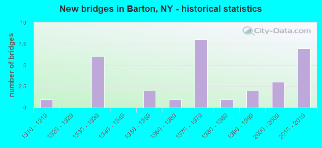
- New bridges - historical statistics
- 11910-1919
- 61930-1939
- 21950-1959
- 11960-1969
- 81970-1979
- 11980-1989
- 21990-1999
- 32000-2009
- 72010-2019
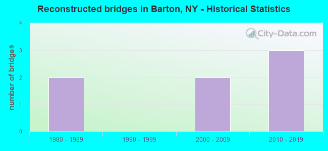
- Reconstructed bridges - Historical Statistics
- 21980-1989
- 01990-1999
- 22000-2009
- 32010-2019
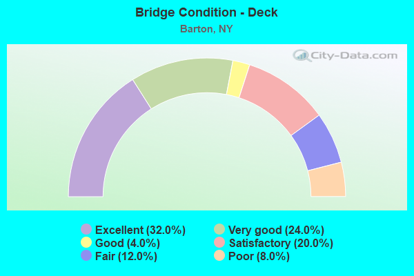
- Bridge Condition - Deck
- 32.0%Excellent
- 24.0%Very good
- 4.0%Good
- 20.0%Satisfactory
- 12.0%Fair
- 8.0%Poor
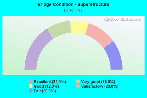
- Bridge Condition - Superstructure
- 32.0%Excellent
- 16.0%Very good
- 12.0%Good
- 20.0%Satisfactory
- 20.0%Fair
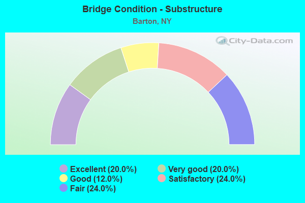
- Bridge Condition - Substructure
- 20.0%Excellent
- 20.0%Very good
- 12.0%Good
- 24.0%Satisfactory
- 24.0%Fair
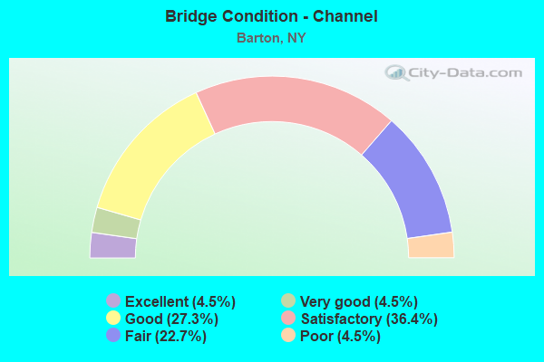
- Bridge Condition - Channel
- 4.5%Excellent
- 4.5%Very good
- 27.3%Good
- 36.4%Satisfactory
- 22.7%Fair
- 4.5%Poor
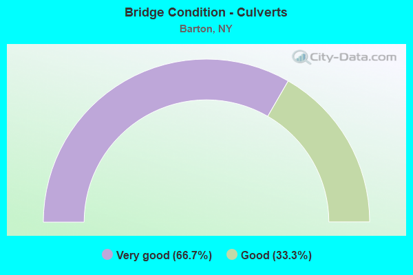
- Bridge Condition - Culverts
- 66.7%Very good
- 33.3%Good
Find on map >> Show street view
Structure Number: 101288, Location: RTE 17C 3.6 MI E WAVERLY (Lat: 42.008333, Lng: -76.480978), Route carried "on" structure: State highway 17C, Year Built: 1931, Status: Open, Structure Length: 1.65m (5.41ft), Average Daily Traffic: 3,605 (year 2019), Truck Traffic: 7%, Average Future Daily Traffic: 4,379 (year 2040), Design Load: H 20, Features Intersected: ELLIS CREEK
Minimum Vertical Clearance: 30+ m (98+ ft), Kilometerpoint: 3.910, Lanes on structure: 2, Base Highway Network: Yes, Owner: State Highway Agency, Approaching Roadway Width: 11.0m (36.1ft), Skew: 1 degrees, Material/Design: Steel, Design/Construction: Stringer/Multi-beam, Number Of Spans In Main Unit: 1, Length of Maximum Span: 15.8m (51.8ft), Curb-To-Curb Width: 10.7m (35.1ft), Out-to-Out Width: 11.4m (37.4ft)
Condition: Deck: Satisfactory, Superstructure: Satisfactory, Substructure: Satisfactory, Channel: Satisfactory, Operating Rating: 39.0 metric tons, Method Used To Determine Operating Rating: Load Factor (LF), Inventory Rating: 22.7 metric tons, Method Used To Determine Inventory Rating: Load Factor (LF), Structural Evaluation: Equal to present minimum criteria, Deck Geometry: Somewhat better than minimum adequacy, Waterway Adequacy: Equal to present desirable criteria, Approach Roadway Alignment: Equal to present desirable criteria, Length Of Structure Improvement: 1.64m (5.38ft), Designated Inspection Frequency: Every 24 months, Inspection Date: April 2020, Bridge Improvement Cost: $648,000, Roadway Improvement Cost: $380,000, Total Project Cost: $1,028,000 ( Estimate for 2021), Deck Structure Type: Concrete Cast-file-Place, Wearing Surface/Protective System: Wearing Surface: Bituminous, Membrane: Other
Find on map >> Show street view
Structure Number: 101289, Location: RTE 17C N END OF BARTON (Lat: 42.045217, Lng: -76.447622), Route carried "on" structure: State highway 17C, Year Built: 1938, Year Reconstructed: 2015, Status: Open, Structure Length: 5.27m (17.29ft), Average Daily Traffic: 2,103 (year 2020), Truck Traffic: 14%, Average Future Daily Traffic: 2,193 (year 2040), Design Load: HL 93, Features Intersected: BUTSON CREEK
Minimum Vertical Clearance: 30+ m (98+ ft), Kilometerpoint: 10.265, Lanes on structure: 2, Base Highway Network: Yes, Owner: State Highway Agency, Approaching Roadway Width: 11.6m (38.1ft), Material/Design: Steel continuous, Design/Construction: Stringer/Multi-beam, Number Of Spans In Main Unit: 3, Length of Maximum Span: 21.0m (68.9ft), Curb-To-Curb Width: 11.6m (38.1ft), Out-to-Out Width: 12.6m (41.3ft)
Condition: Deck: Very good, Superstructure: Excellent, Substructure: Excellent, Channel: Good, Operating Rating: 79.8 metric tons, Method Used To Determine Operating Rating: Load Factor (LF), Inventory Rating: 48.1 metric tons, Method Used To Determine Inventory Rating: Load Factor (LF), Structural Evaluation: Superior to present desirable criteria, Deck Geometry: Somewhat better than minimum adequacy, Waterway Adequacy: Equal to present minimum criteria, Approach Roadway Alignment: Equal to present desirable criteria, Length Of Structure Improvement: 5.27m (17.29ft), Designated Inspection Frequency: Every 24 months, Inspection Date: September 2021, Bridge Improvement Cost: $1,571,000, Roadway Improvement Cost: $920,000, Total Project Cost: $2,491,000 ( Estimate for 2021), Deck Structure Type: Concrete Cast-file-Place, Wearing Surface/Protective System: Wearing Surface: Integral Concrete, Deck Protection: Epoxy Coated Reinforcing
Find on map >> Show street view
Structure Number: 102317, Location: 1.2 MI N OF WAVERLY (Lat: 42.026875, Lng: -76.524064), Route carried "on" structure: State highway 34, Year Built: 2019, Status: Open, Structure Length: 9.33m (30.61ft), Average Daily Traffic: 4,855 (year 2017), Truck Traffic: 6%, Average Future Daily Traffic: 5,064 (year 2040), Design Load: H 20, Features Intersected: CAYUTA CREEK
Minimum Vertical Clearance: 30+ m (98+ ft), Kilometerpoint: 3.282, Lanes on structure: 2, Base Highway Network: Yes, Owner: State Highway Agency, Approaching Roadway Width: 12.2m (40.0ft), Skew: 6 degrees, Material/Design: Steel continuous, Design/Construction: Stringer/Multi-beam, Number Of Spans In Main Unit: 2, Length of Maximum Span: 46.0m (150.9ft), Curb-To-Curb Width: 12.2m (40.0ft), Out-to-Out Width: 13.5m (44.3ft)
Condition: Deck: Excellent, Superstructure: Excellent, Substructure: Very good, Channel: Good, Inventory Rating: 62.6 metric tons, Method Used To Determine Inventory Rating: Load Factor (LF), Structural Evaluation: Equal to present desirable criteria, Deck Geometry: Equal to present minimum criteria, Waterway Adequacy: Somewhat better than minimum adequacy, Approach Roadway Alignment: Equal to present desirable criteria, Length Of Structure Improvement: 9.32m (30.58ft), Designated Inspection Frequency: Every 24 months, Inspection Date: June 2021, Bridge Improvement Cost: $4,142,000, Roadway Improvement Cost: $2,426,000, Total Project Cost: $6,568,000 ( Estimate for 2021), Deck Structure Type: Concrete Cast-file-Place, Wearing Surface/Protective System: Wearing Surface: Monolithic Concrete, Deck Protection: Epoxy Coated Reinforcing
Find on map >> Show street view
Structure Number: 102318, Location: 1.3 MI.N.OF WAVERLY (Lat: 42.028658, Lng: -76.523678), Route carried "on" structure: State highway 34, Year Built: 2019, Status: Open, Structure Length: 3.78m (12.40ft), Average Daily Traffic: 4,855 (year 2017), Truck Traffic: 6%, Average Future Daily Traffic: 5,064 (year 2040), Design Load: HL 93, Features Intersected: MP 274.41 NOR SOU
Minimum Vertical Clearance: 30+ m (98+ ft), Kilometerpoint: 3.556, Lanes on structure: 2, Base Highway Network: Yes, Owner: State Highway Agency, Approaching Roadway Width: 12.2m (40.0ft), Material/Design: Steel, Design/Construction: Stringer/Multi-beam, Number Of Spans In Main Unit: 1, Length of Maximum Span: 34.7m (113.8ft), Curb-To-Curb Width: 12.2m (40.0ft), Out-to-Out Width: 13.5m (44.3ft)
Condition: Deck: Excellent, Superstructure: Excellent, Substructure: Very good, Operating Rating: 80.7 metric tons, Method Used To Determine Operating Rating: Load Factor (LF), Inventory Rating: 48.1 metric tons, Method Used To Determine Inventory Rating: Load Factor (LF), Structural Evaluation: Equal to present desirable criteria, Deck Geometry: Equal to present minimum criteria, Underclear: Superior to present desirable criteria, Approach Roadway Alignment: Equal to present minimum criteria, Length Of Structure Improvement: 3.77m (12.37ft), Designated Inspection Frequency: Every 24 months, Inspection Date: July 2021, Bridge Improvement Cost: $2,047,000, Roadway Improvement Cost: $1,199,000, Total Project Cost: $3,246,000 ( Estimate for 2021), Deck Structure Type: Concrete Cast-file-Place, Wearing Surface/Protective System: Wearing Surface: Monolithic Concrete, Deck Protection: Epoxy Coated Reinforcing
Find on map >> Show street view
Structure Number: 102319, Location: 6.8 MI NORTH OF WAVERLY (Lat: 42.104992, Lng: -76.545883), Route carried "on" structure: State highway 34, Year Built: 1959, Year Reconstructed: 2017, Status: Open, Structure Length: 1.37m (4.49ft), Average Daily Traffic: 1,927 (year 2020), Truck Traffic: 10%, Average Future Daily Traffic: 2,010 (year 2040), Design Load: HL 93, Features Intersected: DEAN CREEK
Minimum Vertical Clearance: 30+ m (98+ ft), Kilometerpoint: 12.421, Lanes on structure: 2, Base Highway Network: Yes, Owner: State Highway Agency, Approaching Roadway Width: 11.0m (36.1ft), Material/Design: Prestressed concrete, Design/Construction: Tee Beam, Number Of Spans In Main Unit: 1, Length of Maximum Span: 12.8m (42.0ft), Curb-To-Curb Width: 11.0m (36.1ft), Out-to-Out Width: 11.9m (39.0ft)
Condition: Deck: Excellent, Superstructure: Excellent, Substructure: Satisfactory, Channel: Good, Operating Rating: 87.1 metric tons, Method Used To Determine Operating Rating: Load Factor (LF), Inventory Rating: 36.3 metric tons, Method Used To Determine Inventory Rating: Load Factor (LF), Structural Evaluation: Equal to present minimum criteria, Deck Geometry: Equal to present minimum criteria, Waterway Adequacy: Somewhat better than minimum adequacy, Approach Roadway Alignment: Equal to present desirable criteria, Length Of Structure Improvement: 1.37m (4.49ft), Designated Inspection Frequency: Every 24 months, Inspection Date: September 2021, Bridge Improvement Cost: $721,000, Roadway Improvement Cost: $422,000, Total Project Cost: $1,144,000 ( Estimate for 2021), Deck Structure Type: Other, Wearing Surface/Protective System: Wearing Surface: Bituminous
Find on map >> Show street view
Structure Number: 1061511, Location: 0.2 MI SE JCT SH17 & SH34 (Lat: 42.000181, Lng: -76.521597), Route carried "on" structure: State highway 17, Year Built: 1973, Year Reconstructed: 1991, Status: Open, Structure Length: 6.71m (22.01ft), Average Daily Traffic: 7,235 (year 2020), Truck Traffic: 28%, Average Future Daily Traffic: 8,384 (year 2040), Design Load: HS 20+Mod, Features Intersected: ITHACA CENTRAL RR
Minimum Vertical Clearance: 32.69m (107.25ft), Kilometerpoint: 2.993, Lanes on structure: 2, Base Highway Network: Yes, Owner: State Highway Agency, Approaching Roadway Width: 11.9m (39.0ft), Skew: 1 degrees, Material/Design: Steel, Design/Construction: Stringer/Multi-beam, Number Of Spans In Main Unit: 3, Length of Maximum Span: 36.2m (118.8ft), Curb-To-Curb Width: 11.9m (39.0ft), Out-to-Out Width: 12.8m (42.0ft)
Condition: Deck: Satisfactory, Superstructure: Fair, Substructure: Fair, Operating Rating: 62.6 metric tons, Method Used To Determine Operating Rating: Load Factor (LF), Inventory Rating: 37.2 metric tons, Method Used To Determine Inventory Rating: Load Factor (LF), Structural Evaluation: Somewhat better than minimum adequacy, Deck Geometry: Equal to present minimum criteria, Underclear: Better than present minimum criteria, Approach Roadway Alignment: Equal to present desirable criteria, Length Of Structure Improvement: 6.70m (21.98ft), Designated Inspection Frequency: Every 24 months, Inspection Date: October 2020, Bridge Improvement Cost: $1,980,000, Roadway Improvement Cost: $1,160,000, Total Project Cost: $3,140,000 ( Estimate for 2021), Deck Structure Type: Concrete Cast-file-Place, Wearing Surface/Protective System: Wearing Surface: Integral Concrete
Find on map >> Show street view
Structure Number: 1061512, Location: .2 MI SE JCT SH 17 & SH 3 (Lat: 41.999967, Lng: -76.521550), Route carried "on" structure: State highway 17, Year Built: 1973, Year Reconstructed: 1991, Status: Open, Structure Length: 6.71m (22.01ft), Average Daily Traffic: 7,235 (year 2020), Truck Traffic: 28%, Average Future Daily Traffic: 8,384 (year 2040), Design Load: HS 20+Mod, Features Intersected: ITHACA CENTRAL RR
Minimum Vertical Clearance: 32.69m (107.25ft), Kilometerpoint: 2.993, Lanes on structure: 2, Base Highway Network: Yes, Owner: State Highway Agency, Approaching Roadway Width: 13.1m (43.0ft), Skew: 1 degrees, Material/Design: Steel, Design/Construction: Stringer/Multi-beam, Number Of Spans In Main Unit: 3, Length of Maximum Span: 36.2m (118.8ft), Curb-To-Curb Width: 11.9m (39.0ft), Out-to-Out Width: 12.8m (42.0ft)
Condition: Deck: Satisfactory, Superstructure: Satisfactory, Substructure: Fair, Operating Rating: 65.3 metric tons, Method Used To Determine Operating Rating: Load Factor (LF), Inventory Rating: 38.1 metric tons, Method Used To Determine Inventory Rating: Load Factor (LF), Structural Evaluation: Somewhat better than minimum adequacy, Deck Geometry: Equal to present minimum criteria, Underclear: Better than present minimum criteria, Approach Roadway Alignment: Equal to present desirable criteria, Length Of Structure Improvement: 6.70m (21.98ft), Designated Inspection Frequency: Every 24 months, Inspection Date: October 2020, Bridge Improvement Cost: $1,980,000, Roadway Improvement Cost: $1,160,000, Total Project Cost: $3,140,000 ( Estimate for 2021), Deck Structure Type: Concrete Cast-file-Place, Wearing Surface/Protective System: Wearing Surface: Integral Concrete
Find on map >> Show street view
Structure Number: 1061521, Location: 2 MI SE JCT SH 17 & SH 34 (Lat: 42.006461, Lng: -76.485050), Route carried "on" structure: State highway 17, Year Built: 1973, Status: Open, Structure Length: 3.57m (11.71ft), Average Daily Traffic: 7,235 (year 2020), Truck Traffic: 28%, Average Future Daily Traffic: 11,290 (year 2040), Design Load: HS 20+Mod, Features Intersected: SHEPARD ROAD
Minimum Vertical Clearance: 30+ m (98+ ft), Kilometerpoint: 6.098, Lanes on structure: 2, Lanes under structure: 2, Base Highway Network: Yes, Owner: State Highway Agency, Approaching Roadway Width: 11.9m (39.0ft), Skew: 3 degrees, Material/Design: Steel, Design/Construction: Stringer/Multi-beam, Number Of Spans In Main Unit: 1, Length of Maximum Span: 34.1m (111.9ft), Curb-To-Curb Width: 12.1m (39.7ft), Out-to-Out Width: 13.0m (42.7ft)
Condition: Deck: Good, Superstructure: Good, Substructure: Good, Operating Rating: 85.3 metric tons, Method Used To Determine Operating Rating: Load Factor (LF), Inventory Rating: 50.8 metric tons, Method Used To Determine Inventory Rating: Load Factor (LF), Structural Evaluation: Better than present minimum criteria, Deck Geometry: Better than present minimum criteria, Underclear: Equal to present minimum criteria, Approach Roadway Alignment: Equal to present desirable criteria, Length Of Structure Improvement: 3.56m (11.68ft), Designated Inspection Frequency: Every 24 months, Inspection Date: July 2020, Bridge Improvement Cost: $1,451,000, Roadway Improvement Cost: $850,000, Total Project Cost: $2,301,000 ( Estimate for 2021), Deck Structure Type: Concrete Cast-file-Place, Wearing Surface/Protective System: Wearing Surface: Monolithic Concrete
Find on map >> Show street view
Structure Number: 1061522, Location: 2 MI SE JCT SH 17 & SH 34 (Lat: 42.006156, Lng: -76.485256), Route carried "on" structure: State highway 17, Year Built: 1973, Status: Open, Structure Length: 3.60m (11.81ft), Average Daily Traffic: 7,235 (year 2020), Truck Traffic: 28%, Average Future Daily Traffic: 11,290 (year 2040), Design Load: HS 20+Mod, Features Intersected: SHEPARD ROAD
Minimum Vertical Clearance: 30+ m (98+ ft), Kilometerpoint: 6.098, Lanes on structure: 2, Lanes under structure: 2, Base Highway Network: Yes, Owner: State Highway Agency, Approaching Roadway Width: 11.9m (39.0ft), Skew: 3 degrees, Material/Design: Steel, Design/Construction: Stringer/Multi-beam, Number Of Spans In Main Unit: 1, Length of Maximum Span: 34.1m (111.9ft), Curb-To-Curb Width: 12.2m (40.0ft), Out-to-Out Width: 13.0m (42.7ft)
Condition: Deck: Very good, Superstructure: Good, Substructure: Good, Operating Rating: 92.5 metric tons, Method Used To Determine Operating Rating: Load Factor (LF), Inventory Rating: 55.3 metric tons, Method Used To Determine Inventory Rating: Load Factor (LF), Structural Evaluation: Better than present minimum criteria, Deck Geometry: Better than present minimum criteria, Underclear: Equal to present minimum criteria, Approach Roadway Alignment: Equal to present desirable criteria, Length Of Structure Improvement: 3.59m (11.78ft), Designated Inspection Frequency: Every 24 months, Inspection Date: July 2020, Bridge Improvement Cost: $1,466,000, Roadway Improvement Cost: $858,000, Total Project Cost: $2,324,000 ( Estimate for 2021), Deck Structure Type: Concrete Cast-file-Place, Wearing Surface/Protective System: Wearing Surface: Monolithic Concrete
Find on map >> Show street view
Structure Number: 106202, Location: 2.2 MI SE JCT SH17 & SH34 (Lat: 42.006531, Lng: -76.480542), Route carried "on" structure: State highway 17, Year Built: 1973, Status: Open, Structure Length: 1.25m (4.10ft), Average Daily Traffic: 14,470 (year 2020), Truck Traffic: 28%, Average Future Daily Traffic: 22,580 (year 2040), Design Load: HS 20+Mod, Features Intersected: ELLIS CREEK
Minimum Vertical Clearance: 30+ m (98+ ft), Kilometerpoint: 6.500, Lanes on structure: 4, Base Highway Network: Yes, Owner: State Highway Agency, Approaching Roadway Width: 23.5m (77.1ft), Skew: 20 degrees, Material/Design: Concrete, Design/Construction: Culvert, Number Of Spans In Main Unit: 2, Length of Maximum Span: 6.0m (19.7ft)
Condition: Channel: Good, Culverts: Good, Operating Rating: 80.7 metric tons, Method Used To Determine Operating Rating: Load Factor (LF), Inventory Rating: 48.1 metric tons, Method Used To Determine Inventory Rating: Load Factor (LF), Structural Evaluation: Better than present minimum criteria, Waterway Adequacy: Equal to present desirable criteria, Approach Roadway Alignment: Equal to present desirable criteria, Length Of Structure Improvement: 1.24m (4.07ft), Designated Inspection Frequency: Every 24 months, Inspection Date: June 2020, Bridge Improvement Cost: $875,000, Roadway Improvement Cost: $512,000, Total Project Cost: $1,387,000 ( Estimate for 2021)
Find on map >> Show street view
Structure Number: 109094, Location: 4.4 MI N OF WAVERLY (Lat: 42.069906, Lng: -76.543344), Route carried "on" structure: State highway 34, Year Built: 1937, Status: Open, Structure Length: 0.70m (2.30ft), Average Daily Traffic: 4,855 (year 2017), Truck Traffic: 6%, Average Future Daily Traffic: 5,064 (year 2040), Design Load: H 20, Features Intersected: KING HOLLOW CREEK
Minimum Vertical Clearance: 30+ m (98+ ft), Kilometerpoint: 8.479, Lanes on structure: 2, Base Highway Network: Yes, Owner: State Highway Agency, Approaching Roadway Width: 10.1m (33.1ft), Skew: 1 degrees, Material/Design: Concrete, Design/Construction: Slab, Number Of Spans In Main Unit: 1, Length of Maximum Span: 6.0m (19.7ft), Curb-To-Curb Width: 9.7m (31.8ft), Out-to-Out Width: 11.0m (36.1ft)
Condition: Deck: Poor, Superstructure: Fair, Substructure: Fair, Channel: Satisfactory, Operating Rating: 41.8 metric tons, Method Used To Determine Operating Rating: Load and Resistance Factor Rating (LRFR) rating reported by rating factor(RF) method using HL-93 loadings, Inventory Rating: 32.1 metric tons, Method Used To Determine Inventory Rating: Load and Resistance Factor Rating (LRFR) rating reported by rating factor(RF) method using HL-93 loadings, Structural Evaluation: Somewhat better than minimum adequacy, Deck Geometry: Meets minimum limits, Waterway Adequacy: Somewhat better than minimum adequacy, Approach Roadway Alignment: Equal to present desirable criteria, Length Of Structure Improvement: 0.70m (2.30ft), Designated Inspection Frequency: Every 24 months, Inspection Date: September 2021, Bridge Improvement Cost: $308,000, Roadway Improvement Cost: $180,000, Total Project Cost: $488,000 ( Estimate for 2021), Wearing Surface/Protective System: Wearing Surface: Bituminous, Membrane: Preformed Fabric
Find on map >> Show street view
Structure Number: 109095, Location: 3.1 MI N OF WAVERLY (Lat: 42.051411, Lng: -76.536294), Route carried "on" structure: State highway 34, Year Built: 1937, Status: Open, Structure Length: 0.70m (2.30ft), Average Daily Traffic: 4,855 (year 2017), Truck Traffic: 6%, Average Future Daily Traffic: 5,064 (year 2040), Design Load: H 20, Features Intersected: RANCH CREEK
Minimum Vertical Clearance: 30+ m (98+ ft), Kilometerpoint: 6.339, Lanes on structure: 2, Base Highway Network: Yes, Owner: State Highway Agency, Approaching Roadway Width: 10.4m (34.1ft), Material/Design: Concrete, Design/Construction: Slab, Number Of Spans In Main Unit: 1, Length of Maximum Span: 6.7m (22.0ft), Curb-To-Curb Width: 9.7m (31.8ft), Out-to-Out Width: 11.0m (36.1ft)
Condition: Deck: Fair, Superstructure: Fair, Substructure: Fair, Channel: Satisfactory, Operating Rating: 78.9 metric tons, Method Used To Determine Operating Rating: Load Factor (LF), Inventory Rating: 47.2 metric tons, Method Used To Determine Inventory Rating: Load Factor (LF), Structural Evaluation: Somewhat better than minimum adequacy, Deck Geometry: Meets minimum limits, Waterway Adequacy: Somewhat better than minimum adequacy, Approach Roadway Alignment: Equal to present desirable criteria, Length Of Structure Improvement: 0.70m (2.30ft), Designated Inspection Frequency: Every 24 months, Inspection Date: August 2020, Bridge Improvement Cost: $302,000, Roadway Improvement Cost: $177,000, Total Project Cost: $479,000 ( Estimate for 2021), Wearing Surface/Protective System: Wearing Surface: Bituminous, Membrane: Preformed Fabric
Find on map >> Show street view
Structure Number: 109096, Location: 2.2 MI N OF WAVERLY (Lat: 42.039289, Lng: -76.528569), Route carried "on" structure: State highway 34, Year Built: 1937, Status: Open, Structure Length: 0.70m (2.30ft), Average Daily Traffic: 4,855 (year 2017), Truck Traffic: 6%, Average Future Daily Traffic: 5,064 (year 2040), Design Load: H 20, Features Intersected: SPRING BROOK
Minimum Vertical Clearance: 30+ m (98+ ft), Kilometerpoint: 4.843, Lanes on structure: 2, Base Highway Network: Yes, Owner: State Highway Agency, Approaching Roadway Width: 10.1m (33.1ft), Material/Design: Concrete, Design/Construction: Slab, Number Of Spans In Main Unit: 1, Length of Maximum Span: 6.7m (22.0ft), Curb-To-Curb Width: 9.6m (31.5ft), Out-to-Out Width: 10.9m (35.8ft)
Condition: Deck: Fair, Superstructure: Fair, Substructure: Fair, Channel: Fair, Operating Rating: 78.9 metric tons, Method Used To Determine Operating Rating: Load Factor (LF), Inventory Rating: 47.2 metric tons, Method Used To Determine Inventory Rating: Load Factor (LF), Structural Evaluation: Somewhat better than minimum adequacy, Deck Geometry: Meets minimum limits, Waterway Adequacy: Meets minimum limits, Approach Roadway Alignment: Equal to present desirable criteria, Length Of Structure Improvement: 0.70m (2.30ft), Designated Inspection Frequency: Every 24 months, Inspection Date: August 2020, Bridge Improvement Cost: $301,000, Roadway Improvement Cost: $176,000, Total Project Cost: $477,000 ( Estimate for 2021), Wearing Surface/Protective System: Wearing Surface: Bituminous, Membrane: Preformed Fabric
Find on map >> Show street view
Structure Number: 221824, Location: 2 MILES SW OF BARTON (Lat: 42.022125, Lng: -76.468389), Route carried "on" structure: Other road , Year Built: 2016, Status: Open, Structure Length: 1.74m (5.71ft), Average Daily Traffic: 172 (year 2019), Truck Traffic: 3%, Average Future Daily Traffic: 241 (year 2039), Design Load: HL 93, Features Intersected: NORFOLK SOUTHERN RR, Facility Carried by Structure: BARTON ROAD
Minimum Vertical Clearance: 30+ m (98+ ft), Kilometerpoint: 0.113, Lanes on structure: 1, Owner: Town or Township Highway Agency, Approaching Roadway Width: 3.7m (12.1ft), Material/Design: Steel, Design/Construction: Stringer/Multi-beam, Number Of Spans In Main Unit: 1, Length of Maximum Span: 17.1m (56.1ft), Curb-To-Curb Width: 3.7m (12.1ft), Out-to-Out Width: 4.3m (14.1ft)
Condition: Deck: Excellent, Superstructure: Excellent, Substructure: Excellent, Operating Rating: 66.2 metric tons, Method Used To Determine Operating Rating: Load Factor (LF), Inventory Rating: 39.0 metric tons, Method Used To Determine Inventory Rating: Load Factor (LF), Structural Evaluation: Superior to present desirable criteria, Deck Geometry: High priority of replacement, Underclear: Somewhat better than minimum adequacy, Approach Roadway Alignment: Somewhat better than minimum adequacy, Length Of Structure Improvement: 1.73m (5.68ft), Designated Inspection Frequency: Every 24 months, Inspection Date: November 2020, Bridge Improvement Cost: $451,000, Roadway Improvement Cost: $264,000, Total Project Cost: $716,000 ( Estimate for 2021), Deck Structure Type: Concrete Cast-file-Place, Wearing Surface/Protective System: Wearing Surface: Monolithic Concrete, Deck Protection: Epoxy Coated Reinforcing
Find on map >> Show street view
Structure Number: 221826, Location: IN BARTON (Lat: 42.041614, Lng: -76.445033), Route carried "on" structure: Other road , Year Built: 2015, Status: Open, Structure Length: 1.16m (3.81ft), Average Daily Traffic: 110 (year 2017), Truck Traffic: 3%, Average Future Daily Traffic: 154 (year 2037), Features Intersected: BUTSON CREEK, Facility Carried by Structure: BARTON ROAD
Minimum Vertical Clearance: 30+ m (98+ ft), Kilometerpoint: 3.588, Lanes on structure: 2, Owner: Town or Township Highway Agency, Approaching Roadway Width: 5.5m (18.0ft), Material/Design: Aluminum, Iron, Design/Construction: Culvert, Number Of Spans In Main Unit: 1, Length of Maximum Span: 10.7m (35.1ft), Curb-To-Curb Width: 7.1m (23.3ft), Out-to-Out Width: 7.4m (24.3ft)
Condition: Channel: Poor, Culverts: Very good, Operating Rating: 80.2 metric tons, Method Used To Determine Operating Rating: Field evaluation and documented engineering judgment, Inventory Rating: 40.8 metric tons, Method Used To Determine Inventory Rating: Field evaluation and documented engineering judgment, Structural Evaluation: Equal to present desirable criteria, Deck Geometry: Meets minimum limits, Waterway Adequacy: Meets minimum limits, Approach Roadway Alignment: Somewhat better than minimum adequacy, Length Of Structure Improvement: 1.15m (3.77ft), Designated Inspection Frequency: Every 24 months, Inspection Date: November 2021, Bridge Improvement Cost: $153,000, Roadway Improvement Cost: $89,000, Total Project Cost: $242,000 ( Estimate for 2021), Wearing Surface/Protective System: Wearing Surface: Other
Find on map >> Show street view
Structure Number: 221828, Location: 3.8 MI N OF WAVERLY (Lat: 42.050994, Lng: -76.539558), Route carried "on" structure: Other road , Year Built: 1938, Status: Open, Structure Length: 0.82m (2.69ft), Average Daily Traffic: 100 (year 2017), Truck Traffic: 3%, Average Future Daily Traffic: 140 (year 2037), Features Intersected: GLORY GULCH CREEK, Facility Carried by Structure: CAMPTOWN ROAD
Minimum Vertical Clearance: 30+ m (98+ ft), Kilometerpoint: 0.338, Lanes on structure: 2, Owner: Town or Township Highway Agency, Approaching Roadway Width: 5.2m (17.1ft), Skew: 2 degrees, Material/Design: Steel, Design/Construction: Stringer/Multi-beam, Number Of Spans In Main Unit: 1, Length of Maximum Span: 7.0m (23.0ft), Curb-To-Curb Width: 6.1m (20.0ft), Out-to-Out Width: 7.0m (23.0ft)
Condition: Deck: Poor, Superstructure: Fair, Substructure: Fair, Channel: Fair, Operating Rating: 48.1 metric tons, Method Used To Determine Operating Rating: Load Factor (LF), Inventory Rating: 29.0 metric tons, Method Used To Determine Inventory Rating: Load Factor (LF), Structural Evaluation: Somewhat better than minimum adequacy, Deck Geometry: Somewhat better than minimum adequacy, Waterway Adequacy: Meets minimum limits, Approach Roadway Alignment: Equal to present minimum criteria, Length Of Structure Improvement: 0.82m (2.69ft), Designated Inspection Frequency: Every 24 months, Inspection Date: June 2021, Bridge Improvement Cost: $230,000, Roadway Improvement Cost: $135,000, Total Project Cost: $365,000 ( Estimate for 2021), Deck Structure Type: Concrete Cast-file-Place, Wearing Surface/Protective System: Wearing Surface: Bituminous
Find on map >> Show street view
Structure Number: 221831, Location: 1.0 MI S OF LOCKWOOD (Lat: 42.076808, Lng: -76.547417), Route carried "on" structure: Other road , Year Built: 2007, Status: Open, Structure Length: 3.60m (11.81ft), Average Daily Traffic: 43 (year 2019), Average Future Daily Traffic: 60 (year 2039), Features Intersected: CAYUTA CREEK, Facility Carried by Structure: MILLER HOLLOW RD.
Minimum Vertical Clearance: 30+ m (98+ ft), Kilometerpoint: 0.129, Lanes on structure: 1, Owner: County Highway Agency, Approaching Roadway Width: 4.3m (14.1ft), Material/Design: Prestressed concrete, Design/Construction: Box Beam or Girders - Multiple, Number Of Spans In Main Unit: 1, Length of Maximum Span: 31.4m (103.0ft), Curb-To-Curb Width: 4.3m (14.1ft), Out-to-Out Width: 5.1m (16.7ft)
Condition: Deck: Excellent, Superstructure: Very good, Substructure: Excellent, Channel: Very good, Inventory Rating: 55.3 metric tons, Method Used To Determine Inventory Rating: Load Factor (LF), Structural Evaluation: Equal to present desirable criteria, Deck Geometry: Equal to present minimum criteria, Waterway Adequacy: Equal to present minimum criteria, Approach Roadway Alignment: Equal to present minimum criteria, Length Of Structure Improvement: 3.59m (11.78ft), Designated Inspection Frequency: Every 24 months, Inspection Date: September 2020, Bridge Improvement Cost: $402,000, Roadway Improvement Cost: $236,000, Total Project Cost: $638,000 ( Estimate for 2021), Deck Structure Type: Concrete Cast-file-Place, Wearing Surface/Protective System: Wearing Surface: Integral Concrete
Find on map >> Show street view
Structure Number: 221832, Location: 1.9 MI N OF LOCKWOOD (Lat: 42.116244, Lng: -76.547214), Route carried "on" structure: Other road , Year Built: 1958, Year Reconstructed: 2007, Status: Open, Structure Length: 5.46m (17.91ft), Average Daily Traffic: 66 (year 2017), Truck Traffic: 9%, Average Future Daily Traffic: 92 (year 2037), Design Load: HS 20, Features Intersected: CAYUTA CREEK, Facility Carried by Structure: RENIFF ROAD
Minimum Vertical Clearance: 30+ m (98+ ft), Kilometerpoint: 0.016, Lanes on structure: 1, Owner: County Highway Agency, Approaching Roadway Width: 3.7m (12.1ft), Material/Design: Steel, Design/Construction: Stringer/Multi-beam, Number Of Spans In Main Unit: 3, Length of Maximum Span: 17.6m (57.7ft), Curb-To-Curb Width: 3.9m (12.8ft), Out-to-Out Width: 5.3m (17.4ft)
Condition: Deck: Fair, Superstructure: Satisfactory, Substructure: Satisfactory, Channel: Fair, Operating Rating: 71.7 metric tons, Method Used To Determine Operating Rating: Load Factor (LF), Inventory Rating: 42.6 metric tons, Method Used To Determine Inventory Rating: Load Factor (LF), Structural Evaluation: Equal to present minimum criteria, Deck Geometry: Meets minimum limits, Waterway Adequacy: Meets minimum limits, Approach Roadway Alignment: Somewhat better than minimum adequacy, Length Of Structure Improvement: 5.45m (17.88ft), Designated Inspection Frequency: Every 24 months, Inspection Date: June 2021, Bridge Improvement Cost: $640,000, Roadway Improvement Cost: $375,000, Total Project Cost: $1,015,000 ( Estimate for 2021), Deck Structure Type: Open Grating, Wearing Surface/Protective System: Wearing Surface: Other
Find on map >> Show street view
Structure Number: 333479, Location: 3.1 MI S OF LOCKWOOD (Lat: 42.050667, Lng: -76.537672), Route carried "on" structure: Other road , Year Built: 2008, Status: Open, Structure Length: 3.35m (10.99ft), Average Daily Traffic: 100 (year 2017), Truck Traffic: 3%, Average Future Daily Traffic: 140 (year 2037), Design Load: HS 25 or greater, Features Intersected: CAYUTA CREEK, Facility Carried by Structure: CAMPTOWN ROAD
Minimum Vertical Clearance: 30+ m (98+ ft), Kilometerpoint: 0.129, Lanes on structure: 2, Owner: County Highway Agency, Approaching Roadway Width: 6.1m (20.0ft), Material/Design: Prestressed concrete continuous, Design/Construction: Box Beam or Girders - Multiple, Number Of Spans In Main Unit: 2, Length of Maximum Span: 15.5m (50.9ft), Curb-To-Curb Width: 6.6m (21.7ft), Out-to-Out Width: 7.6m (24.9ft)
Condition: Deck: Very good, Superstructure: Very good, Substructure: Very good, Channel: Excellent, Inventory Rating: 85.3 metric tons, Method Used To Determine Inventory Rating: Load Factor (LF), Structural Evaluation: Equal to present desirable criteria, Deck Geometry: Somewhat better than minimum adequacy, Waterway Adequacy: Equal to present minimum criteria, Approach Roadway Alignment: Equal to present minimum criteria, Length Of Structure Improvement: 3.35m (10.99ft), Designated Inspection Frequency: Every 24 months, Inspection Date: October 2020, Bridge Improvement Cost: $679,000, Roadway Improvement Cost: $398,000, Total Project Cost: $1,077,000 ( Estimate for 2021), Deck Structure Type: Concrete Cast-file-Place, Wearing Surface/Protective System: Wearing Surface: Bituminous, Deck Protection: Epoxy Coated Reinforcing
Find on map >> Show street view
Structure Number: 33348, Location: IN LOCKWOOD (Lat: 42.091942, Lng: -76.547122), Route carried "on" structure: Other road , Year Built: 1960, Year Reconstructed: 2011, Status: Open, Structure Length: 4.72m (15.49ft), Average Daily Traffic: 512 (year 2017), Truck Traffic: 8%, Average Future Daily Traffic: 717 (year 2037), Design Load: HL 93, Features Intersected: CAYUTA CREEK, Facility Carried by Structure: MAIN STREET
Minimum Vertical Clearance: 30+ m (98+ ft), Kilometerpoint: 0.048, Lanes on structure: 2, Owner: County Highway Agency, Approaching Roadway Width: 7.9m (25.9ft), Skew: 1 degrees, Material/Design: Steel continuous, Design/Construction: Stringer/Multi-beam, Number Of Spans In Main Unit: 2, Length of Maximum Span: 22.8m (74.8ft), Curb-To-Curb Width: 8.5m (27.9ft), Out-to-Out Width: 9.4m (30.8ft)
Condition: Deck: Excellent, Superstructure: Excellent, Substructure: Very good, Channel: Satisfactory, Inventory Rating: 62.6 metric tons, Method Used To Determine Inventory Rating: Load Factor (LF), Structural Evaluation: Equal to present desirable criteria, Deck Geometry: Somewhat better than minimum adequacy, Waterway Adequacy: Meets minimum limits, Approach Roadway Alignment: Equal to present minimum criteria, Length Of Structure Improvement: 4.72m (15.49ft), Designated Inspection Frequency: Every 24 months, Inspection Date: November 2021, Bridge Improvement Cost: $1,025,000, Roadway Improvement Cost: $600,000, Total Project Cost: $1,624,000 ( Estimate for 2021), Deck Structure Type: Concrete Cast-file-Place, Wearing Surface/Protective System: Wearing Surface: Integral Concrete, Deck Protection: Epoxy Coated Reinforcing
Find on map >> Show street view
Structure Number: 333482, Location: 1 MILE NE OF LOCKWOOD (Lat: 42.106572, Lng: -76.541039), Route carried "on" structure: County highway , Year Built: 1990, Year Reconstructed: 2018, Status: Open, Structure Length: 1.49m (4.89ft), Average Daily Traffic: 552 (year 2017), Truck Traffic: 8%, Average Future Daily Traffic: 773 (year 2037), Design Load: HS 20, Features Intersected: DEAN CREEK, Facility Carried by Structure: DEAN CREEK ROAD
Minimum Vertical Clearance: 30+ m (98+ ft), Kilometerpoint: 0.467, Lanes on structure: 2, Owner: County Highway Agency, Approaching Roadway Width: 7.3m (24.0ft), Skew: 5 degrees, Material/Design: Steel, Design/Construction: Stringer/Multi-beam, Number Of Spans In Main Unit: 1, Length of Maximum Span: 10.9m (35.8ft), Curb-To-Curb Width: 7.5m (24.6ft), Out-to-Out Width: 8.1m (26.6ft)
Condition: Deck: Excellent, Superstructure: Satisfactory, Substructure: Satisfactory, Channel: Satisfactory, Operating Rating: 52.6 metric tons, Method Used To Determine Operating Rating: Allowable Stress (AS), Inventory Rating: 36.3 metric tons, Method Used To Determine Inventory Rating: Allowable Stress (AS), Structural Evaluation: Equal to present minimum criteria, Deck Geometry: Meets minimum limits, Waterway Adequacy: Somewhat better than minimum adequacy, Approach Roadway Alignment: Equal to present minimum criteria, Length Of Structure Improvement: 1.49m (4.89ft), Designated Inspection Frequency: Every 24 months, Inspection Date: October 2020, Bridge Improvement Cost: $745,000, Roadway Improvement Cost: $436,000, Total Project Cost: $1,181,000 ( Estimate for 2021), Deck Structure Type: Wood or Timber, Wearing Surface/Protective System: Wearing Surface: Bituminous, Membrane: Other
Find on map >> Show street view
Structure Number: 333487, Location: IN WAVERLY (Lat: 42.003133, Lng: -76.522142), Route carried "on" structure: Other road , Year Built: 1978, Status: Open, Structure Length: 12.71m (41.70ft), Average Daily Traffic: 5,235 (year 2017), Truck Traffic: 9%, Average Future Daily Traffic: 6,477 (year 2040), Design Load: HS 20, Features Intersected: NORFOLK SOUTHERN R.R., C, Facility Carried by Structure: BROAD STREET EXTEN
Minimum Vertical Clearance: 30+ m (98+ ft), Kilometerpoint: 0.225, Lanes on structure: 2, Owner: County Highway Agency, Approaching Roadway Width: 13.4m (44.0ft), Material/Design: Steel continuous, Design/Construction: Stringer/Multi-beam, Number Of Spans In Main Unit: 4, Length of Maximum Span: 33.2m (108.9ft), Curb-To-Curb Width: 13.3m (43.6ft), Out-to-Out Width: 14.3m (46.9ft)
Condition: Deck: Very good, Superstructure: Very good, Substructure: Satisfactory, Channel: Good, Operating Rating: 75.3 metric tons, Method Used To Determine Operating Rating: Load Factor (LF), Inventory Rating: 45.4 metric tons, Method Used To Determine Inventory Rating: Load Factor (LF), Structural Evaluation: Equal to present minimum criteria, Deck Geometry: Somewhat better than minimum adequacy, Underclear: Equal to present desirable criteria, Waterway Adequacy: Somewhat better than minimum adequacy, Approach Roadway Alignment: Better than present minimum criteria, Length Of Structure Improvement: 12.71m (41.70ft), Designated Inspection Frequency: Every 24 months, Inspection Date: October 2021, Bridge Improvement Cost: $3,964,000, Roadway Improvement Cost: $2,322,000, Total Project Cost: $6,286,000 ( Estimate for 2021), Deck Structure Type: Concrete Cast-file-Place, Wearing Surface/Protective System: Wearing Surface: Integral Concrete, Deck Protection: Epoxy Coated Reinforcing
Find on map >> Show street view
Structure Number: 333488, Location: 1.9 MI WEST OF BARTON (Lat: 42.039944, Lng: -76.482783), Route carried "on" structure: County highway , Year Built: 2016, Status: Open, Structure Length: 2.23m (7.32ft), Average Daily Traffic: 389 (year 2017), Truck Traffic: 13%, Average Future Daily Traffic: 545 (year 2037), Design Load: HS 20, Features Intersected: ELLIS CREEK, Facility Carried by Structure: ELLIS CREEK ROAD
Minimum Vertical Clearance: 30+ m (98+ ft), Kilometerpoint: 3.652, Lanes on structure: 2, Owner: County Highway Agency, Approaching Roadway Width: 5.5m (18.0ft), Skew: 3 degrees, Material/Design: Steel, Design/Construction: Stringer/Multi-beam, Number Of Spans In Main Unit: 1, Length of Maximum Span: 20.4m (66.9ft), Curb-To-Curb Width: 7.7m (25.3ft), Out-to-Out Width: 8.4m (27.6ft)
Condition: Deck: Excellent, Superstructure: Excellent, Substructure: Very good, Channel: Satisfactory, Operating Rating: 56.2 metric tons, Method Used To Determine Operating Rating: Load Factor (LF), Inventory Rating: 43.5 metric tons, Method Used To Determine Inventory Rating: Load Factor (LF), Structural Evaluation: Equal to present desirable criteria, Deck Geometry: Somewhat better than minimum adequacy, Waterway Adequacy: Meets minimum limits, Approach Roadway Alignment: Equal to present desirable criteria, Length Of Structure Improvement: 2.22m (7.28ft), Designated Inspection Frequency: Every 24 months, Inspection Date: October 2020, Bridge Improvement Cost: $600,000, Roadway Improvement Cost: $351,000, Total Project Cost: $952,000 ( Estimate for 2021), Deck Structure Type: Concrete Cast-file-Place, Wearing Surface/Protective System: Wearing Surface: Monolithic Concrete, Deck Protection: Epoxy Coated Reinforcing
Find on map >> Show street view
Structure Number: 333489, Location: 2.3 MI NW OF BARTON (Lat: 42.060136, Lng: -76.485583), Route carried "on" structure: County highway , Year Built: 2003, Status: Open, Structure Length: 1.10m (3.61ft), Average Daily Traffic: 421 (year 2016), Truck Traffic: 16%, Average Future Daily Traffic: 589 (year 2036), Features Intersected: ELLIS CREEK, Facility Carried by Structure: ELLIS CREEK ROAD
Minimum Vertical Clearance: 30+ m (98+ ft), Kilometerpoint: 6.002, Lanes on structure: 2, Owner: County Highway Agency, Approaching Roadway Width: 6.1m (20.0ft), Skew: 2 degrees, Material/Design: Aluminum, Iron, Design/Construction: Culvert, Number Of Spans In Main Unit: 1, Length of Maximum Span: 10.7m (35.1ft)
Condition: Channel: Satisfactory, Culverts: Very good, Operating Rating: 80.2 metric tons, Method Used To Determine Operating Rating: Field evaluation and documented engineering judgment, Inventory Rating: 40.8 metric tons, Method Used To Determine Inventory Rating: Field evaluation and documented engineering judgment, Structural Evaluation: Equal to present desirable criteria, Waterway Adequacy: Equal to present desirable criteria, Approach Roadway Alignment: Equal to present desirable criteria, Length Of Structure Improvement: 1.09m (3.58ft), Designated Inspection Frequency: Every 24 months, Inspection Date: June 2020, Bridge Improvement Cost: $119,000, Roadway Improvement Cost: $69,000, Total Project Cost: $188,000 ( Estimate for 2021)
Find on map >> Show street view
Structure Number: 33349, Location: 2.6 MI NW OF BARTON (Lat: 42.068800, Lng: -76.484014), Route carried "on" structure: County highway , Year Built: 2015, Status: Open, Structure Length: 1.74m (5.71ft), Average Daily Traffic: 421 (year 2016), Truck Traffic: 16%, Average Future Daily Traffic: 589 (year 2036), Design Load: HS 20, Features Intersected: ELLIS CREEK, Facility Carried by Structure: COUNTY ROAD 9
Minimum Vertical Clearance: 30+ m (98+ ft), Kilometerpoint: 7.112, Lanes on structure: 2, Owner: County Highway Agency, Approaching Roadway Width: 7.3m (24.0ft), Skew: 1 degrees, Material/Design: Prestressed concrete, Design/Construction: Box Beam or Girders - Multiple, Number Of Spans In Main Unit: 1, Length of Maximum Span: 16.5m (54.1ft), Curb-To-Curb Width: 7.3m (24.0ft), Out-to-Out Width: 8.4m (27.6ft)
Condition: Deck: Satisfactory, Superstructure: Excellent, Substructure: Excellent, Channel: Fair, Operating Rating: 83.5 metric tons, Method Used To Determine Operating Rating: Load Factor (LF), Inventory Rating: 49.9 metric tons, Method Used To Determine Inventory Rating: Load Factor (LF), Structural Evaluation: Superior to present desirable criteria, Deck Geometry: Meets minimum limits, Waterway Adequacy: Equal to present minimum criteria, Approach Roadway Alignment: Somewhat better than minimum adequacy, Length Of Structure Improvement: 1.73m (5.68ft), Designated Inspection Frequency: Every 24 months, Inspection Date: October 2021, Bridge Improvement Cost: $382,000, Roadway Improvement Cost: $224,000, Total Project Cost: $606,000 ( Estimate for 2021), Deck Structure Type: Concrete Cast-file-Place, Wearing Surface/Protective System: Wearing Surface: Integral Concrete, Deck Protection: Epoxy Coated Reinforcing
Find on map >> Show street view
Structure Number: 333494, Location: 0.5 MILE NORTH OF BARTON (Lat: 42.049167, Lng: -76.451553), Route carried "on" structure: Alternate County highway , Year Built: 1990, Status: Open, Structure Length: 1.46m (4.79ft), Average Daily Traffic: 345 (year 2017), Truck Traffic: 4%, Average Future Daily Traffic: 483 (year 2037), Design Load: HS 20, Features Intersected: BUTSON CREEK, Facility Carried by Structure: COUNTY RD 11
Minimum Vertical Clearance: 30+ m (98+ ft), Kilometerpoint: 0.981, Lanes on structure: 2, Owner: County Highway Agency, Approaching Roadway Width: 4.9m (16.1ft), Skew: 1 degrees, Material/Design: Wood or Timber, Design/Construction: Stringer/Multi-beam, Number Of Spans In Main Unit: 1, Length of Maximum Span: 14.0m (45.9ft), Curb-To-Curb Width: 7.3m (24.0ft), Out-to-Out Width: 7.9m (25.9ft)
Condition: Deck: Very good, Superstructure: Good, Substructure: Good, Channel: Satisfactory, Operating Rating: 41.7 metric tons, Method Used To Determine Operating Rating: Allowable Stress (AS), Inventory Rating: 27.2 metric tons, Method Used To Determine Inventory Rating: Allowable Stress (AS), Structural Evaluation: Equal to present minimum criteria, Deck Geometry: Somewhat better than minimum adequacy, Waterway Adequacy: Equal to present desirable criteria, Approach Roadway Alignment: Equal to present minimum criteria, Length Of Structure Improvement: 1.46m (4.79ft), Designated Inspection Frequency: Every 24 months, Inspection Date: March 2020, Bridge Improvement Cost: $492,000, Roadway Improvement Cost: $288,000, Total Project Cost: $780,000 ( Estimate for 2021), Deck Structure Type: Wood or Timber, Wearing Surface/Protective System: Wearing Surface: Bituminous
Find on map >> Show street view
Structure Number: 333495, Location: 3.7 MI SW STRAITS CORNERS (Lat: 42.136778, Lng: -76.445172), Route carried "on" structure: County highway , Year Built: 2015, Status: Open, Structure Length: 1.22m (4.00ft), Average Daily Traffic: 154 (year 2017), Truck Traffic: 7%, Average Future Daily Traffic: 216 (year 2037), Design Load: HL 93, Features Intersected: S BR CATATONK CREEK, Facility Carried by Structure: HAMILTON VALLEY RO
Minimum Vertical Clearance: 30+ m (98+ ft), Kilometerpoint: 2.462, Lanes on structure: 2, Owner: County Highway Agency, Approaching Roadway Width: 6.7m (22.0ft), Skew: 4 degrees, Material/Design: Concrete, Design/Construction: Frame, Number Of Spans In Main Unit: 1, Length of Maximum Span: 11.9m (39.0ft), Curb-To-Curb Width: 8.4m (27.6ft), Out-to-Out Width: 9.8m (32.2ft)
Condition: Deck: Very good, Superstructure: Very good, Substructure: Excellent, Channel: Good, Operating Rating: 45.4 metric tons, Method Used To Determine Operating Rating: Load and Resistance Factor Rating (LRFR) rating reported by rating factor(RF) method using HL-93 loadings, Inventory Rating: 35.0 metric tons, Method Used To Determine Inventory Rating: Load and Resistance Factor Rating (LRFR) rating reported by rating factor(RF) method using HL-93 loadings, Structural Evaluation: Equal to present desirable criteria, Deck Geometry: Somewhat better than minimum adequacy, Waterway Adequacy: Equal to present desirable criteria, Approach Roadway Alignment: Somewhat better than minimum adequacy, Length Of Structure Improvement: 1.21m (3.97ft), Designated Inspection Frequency: Every 24 months, Inspection Date: August 2021, Bridge Improvement Cost: $266,000, Roadway Improvement Cost: $156,000, Total Project Cost: $421,000 ( Estimate for 2021)
Find on map >> Show street view
Structure Number: 335933, Location: 1.4 MI NE OF LOCKWOOD (Lat: 42.114611, Lng: -76.531944), Route carried "on" structure: County highway , Year Built: 1985, Status: Open, Structure Length: 1.10m (3.61ft), Average Daily Traffic: 552 (year 2017), Truck Traffic: 8%, Average Future Daily Traffic: 773 (year 2037), Design Load: HS 20, Features Intersected: DEAN CREEK, Facility Carried by Structure: DEAN CREEK ROAD
Minimum Vertical Clearance: 30+ m (98+ ft), Kilometerpoint: 1.641, Lanes on structure: 2, Owner: County Highway Agency, Approaching Roadway Width: 7.3m (24.0ft), Material/Design: Wood or Timber, Design/Construction: Slab, Number Of Spans In Main Unit: 1, Length of Maximum Span: 10.6m (34.8ft), Curb-To-Curb Width: 10.7m (35.1ft), Out-to-Out Width: 11.0m (36.1ft)
Condition: Deck: Satisfactory, Superstructure: Satisfactory, Substructure: Satisfactory, Channel: Fair, Operating Rating: 33.6 metric tons, Method Used To Determine Operating Rating: Load Factor (LF), Inventory Rating: 24.5 metric tons, Method Used To Determine Inventory Rating: Load Factor (LF), Structural Evaluation: Equal to present minimum criteria, Deck Geometry: Equal to present minimum criteria, Waterway Adequacy: Meets minimum limits, Approach Roadway Alignment: Equal to present desirable criteria, Length Of Structure Improvement: 1.09m (3.58ft), Designated Inspection Frequency: Every 24 months, Inspection Date: June 2021, Bridge Improvement Cost: $412,000, Roadway Improvement Cost: $241,000, Total Project Cost: $653,000 ( Estimate for 2021), Wearing Surface/Protective System: Wearing Surface: Bituminous
Find on map >> Show street view
Structure Number: 1061521, Location: 2 MI SE JCT SH 17 & SH 34 (Lat: 42.006461, Lng: -76.485050), Route carried "under" structure: Other road , Year Built: 1973, Structure Length: 0. m, Features Intersected: SHEPARD ROAD, Facility Carried by Structure: RTE 17
Minimum Vertical Clearance: 4.72m (15.49ft), Kilometerpoint: 0.064, Lanes on structure: 2, Lanes under structure: 2, Material/Design: Steel, Design/Construction: Stringer/Multi-beam, Length of Maximum Span: 34.1m (111.9ft)
Find on map >> Show street view
Structure Number: 1061522, Location: 2 MI SE JCT SH 17 & SH 34 (Lat: 42.006156, Lng: -76.485256), Route carried "under" structure: Other road , Year Built: 1973, Structure Length: 0. m, Features Intersected: SHEPARD ROAD, Facility Carried by Structure: RTE 17
Minimum Vertical Clearance: 4.67m (15.32ft), Kilometerpoint: 0.209, Lanes on structure: 2, Lanes under structure: 2, Material/Design: Steel, Design/Construction: Stringer/Multi-beam, Length of Maximum Span: 34.1m (111.9ft)
Find on map >> Show street view
Structure Number: 721833, Location: 3.1 MI SW OF BARTON (Lat: 42.007658, Lng: -76.484167), Route carried "under" structure: Other road , Year Built: 1915, Structure Length: 0. m, Features Intersected: SHEPHERD ROAD, Facility Carried by Structure: NORFOLK SOUTHERN
Minimum Vertical Clearance: 4.42m (14.50ft), Kilometerpoint: 0.000, Lanes under structure: 2, Material/Design: Steel, Design/Construction: Girder and Floorbeam System, Length of Maximum Span: 11.2m (36.7ft)