Bridge Statistics for Barstow, Texas (TX)
Condition, Traffic, Stress, Structural Evaluation, Project Costs
- National Bridge Inventory (NBI) Statistics
- 28Number of bridges
- 371ft / 113mTotal length
- $13,000Total costs
- 137,046Total average daily traffic
- 53,581Total average daily truck traffic
- National Bridge Inventory (NBI) Registered Bridges for Barstow
- No street view available for this location
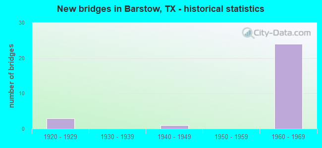
- New bridges - historical statistics
- 31920-1929
- 11940-1949
- 241960-1969

- Reconstructed bridges - Historical Statistics
- 11930-1939
- 01940-1949
- 21950-1959
- 01960-1969
- 11970-1979
- 31980-1989


- Bridge Condition - Deck
- 33.3%Very good
- 16.7%Good
- 16.7%Satisfactory
- 33.3%Fair

- Bridge Condition - Superstructure
- 33.3%Good
- 33.3%Satisfactory
- 33.3%Fair

- Bridge Condition - Substructure
- 16.7%Good
- 33.3%Satisfactory
- 50.0%Fair

- Bridge Condition - Channel
- 50.0%Very good
- 33.3%Good
- 16.7%Satisfactory

- Bridge Condition - Culverts
- 10.0%Good
- 75.0%Satisfactory
- 15.0%Fair
Find on map >> Show street view
Structure Number: 61950000307072, Location: 3.55 MI E OF US 285 (Lat: 31.411669, Lng: -103.425089), Route carried "on" structure: Interstate 20, Year Built: 1966, Status: Open, Structure Length: 0.70m (2.30ft), Average Daily Traffic: 14,055 (year 2020), Truck Traffic: 62%, Average Future Daily Traffic: 9,830 (year 2033), Design Load: HS 20, Features Intersected: DRAW
Minimum Vertical Clearance: 30+ m (98+ ft), Kilometerpoint: 84.650, Lanes on structure: 4, Owner: State Highway Agency, Approaching Roadway Width: 23.2m (76.1ft), Skew: 20 degrees, Material/Design: Concrete, Design/Construction: Culvert, Number Of Spans In Main Unit: 4, Length of Maximum Span: 1.5m (4.9ft)
Condition: Channel: Very good, Culverts: Satisfactory, Operating Rating: 39.9 metric tons, Method Used To Determine Operating Rating: Load Factor (LF), Inventory Rating: 23.6 metric tons, Method Used To Determine Inventory Rating: Load Factor (LF), Structural Evaluation: Somewhat better than minimum adequacy, Waterway Adequacy: Superior to present desirable criteria, Approach Roadway Alignment: Equal to present desirable criteria, Designated Inspection Frequency: Every 24 months, Inspection Date: March 2021
Find on map >> Show street view
Structure Number: 61950000307073, Location: 5.85 MI E OF US 285 (Lat: 31.425994, Lng: -103.390117), Route carried "on" structure: Interstate 20, Year Built: 1966, Status: Open, Structure Length: 1.34m (4.40ft), Average Daily Traffic: 14,055 (year 2020), Truck Traffic: 62%, Average Future Daily Traffic: 9,830 (year 2033), Design Load: HS 20, Features Intersected: DRAW
Minimum Vertical Clearance: 30+ m (98+ ft), Kilometerpoint: 88.395, Lanes on structure: 4, Owner: State Highway Agency, Approaching Roadway Width: 23.2m (76.1ft), Skew: 20 degrees, Material/Design: Concrete, Design/Construction: Culvert, Number Of Spans In Main Unit: 5, Length of Maximum Span: 2.4m (7.9ft), Curb-To-Curb Width: 23.2m (76.1ft), Out-to-Out Width: 39.4m (129.3ft)
Condition: Channel: Good, Culverts: Satisfactory, Operating Rating: 39.9 metric tons, Method Used To Determine Operating Rating: Load Factor (LF), Inventory Rating: 23.6 metric tons, Method Used To Determine Inventory Rating: Load Factor (LF), Structural Evaluation: Somewhat better than minimum adequacy, Deck Geometry: Superior to present desirable criteria, Waterway Adequacy: Superior to present desirable criteria, Approach Roadway Alignment: Equal to present desirable criteria, Designated Inspection Frequency: Every 24 months, Inspection Date: March 2021, Deck Structure Type: Concrete Cast-file-Place, Wearing Surface/Protective System: Wearing Surface: Bituminous
Find on map >> Show street view
Structure Number: 62380000401004, Location: 2.50 Mi E of Reeves C/L (Lat: 31.447886, Lng: -103.427944), Route carried "on" structure: Business State highway 20, Year Built: 1927, Year Reconstructed: 1962, Status: Open, Structure Length: 3.84m (12.60ft), Average Daily Traffic: 3,730 (year 2013), Truck Traffic: 5%, Average Future Daily Traffic: 5,230 (year 2033), Design Load: H 15, Features Intersected: Draw
Minimum Vertical Clearance: 30+ m (98+ ft), Kilometerpoint: 20.081, Lanes on structure: 2, Owner: State Highway Agency, Approaching Roadway Width: 13.4m (44.0ft), Material/Design: Concrete, Design/Construction: Slab, Number Of Spans In Main Unit: 9, Length of Maximum Span: 4.3m (14.1ft), Curb-To-Curb Width: 13.3m (43.6ft), Out-to-Out Width: 13.8m (45.3ft)
Condition: Deck: Fair, Superstructure: Fair, Substructure: Fair, Channel: Good, Operating Rating: 33.6 metric tons, Method Used To Determine Operating Rating: Load Factor (LF), Inventory Rating: 20.0 metric tons, Method Used To Determine Inventory Rating: Load Factor (LF), Structural Evaluation: Somewhat better than minimum adequacy, Deck Geometry: Equal to present minimum criteria, Waterway Adequacy: Equal to present minimum criteria, Approach Roadway Alignment: Equal to present desirable criteria, Designated Inspection Frequency: Every 24 months, Inspection Date: September 2021, Deck Structure Type: Concrete Cast-file-Place, Wearing Surface/Protective System: Wearing Surface: Bituminous
Find on map >> Show street view
Structure Number: 62380000401005, Location: 2.65 Mi E of Reeves C/L (Lat: 31.448664, Lng: -103.424969), Route carried "on" structure: Business State highway 20, Year Built: 1927, Year Reconstructed: 1962, Status: Open, Structure Length: 3.41m (11.19ft), Average Daily Traffic: 3,730 (year 2013), Truck Traffic: 5%, Average Future Daily Traffic: 5,230 (year 2033), Design Load: H 15, Features Intersected: Draw
Minimum Vertical Clearance: 30+ m (98+ ft), Kilometerpoint: 20.406, Lanes on structure: 2, Owner: State Highway Agency, Approaching Roadway Width: 13.4m (44.0ft), Material/Design: Concrete, Design/Construction: Slab, Number Of Spans In Main Unit: 8, Length of Maximum Span: 4.3m (14.1ft), Curb-To-Curb Width: 13.3m (43.6ft), Out-to-Out Width: 13.8m (45.3ft)
Condition: Deck: Fair, Superstructure: Fair, Substructure: Fair, Channel: Good, Operating Rating: 33.6 metric tons, Method Used To Determine Operating Rating: Load Factor (LF), Inventory Rating: 20.0 metric tons, Method Used To Determine Inventory Rating: Load Factor (LF), Structural Evaluation: Somewhat better than minimum adequacy, Deck Geometry: Equal to present minimum criteria, Waterway Adequacy: Equal to present minimum criteria, Approach Roadway Alignment: Equal to present desirable criteria, Length Of Structure Improvement: 3.41m (11.19ft), Designated Inspection Frequency: Every 24 months, Inspection Date: September 2021, Bridge Improvement Cost: $10,000, Roadway Improvement Cost: $3,000, Total Project Cost: $13,000, Deck Structure Type: Concrete Cast-file-Place, Wearing Surface/Protective System: Wearing Surface: Bituminous
Find on map >> Show street view
Structure Number: 62380000401017, Location: 1.40 MI NE OF FM 516 (Lat: 31.463928, Lng: -103.370333), Route carried "on" structure: Business State highway 20, Year Built: 1925, Year Reconstructed: 1941, Status: Open, Structure Length: 0.82m (2.69ft), Average Daily Traffic: 2,150 (year 2013), Truck Traffic: 6%, Average Future Daily Traffic: 3,010 (year 2033), Design Load: H 15, Features Intersected: DRAW
Minimum Vertical Clearance: 30+ m (98+ ft), Kilometerpoint: 25.833, Lanes on structure: 2, Owner: State Highway Agency, Approaching Roadway Width: 12.2m (40.0ft), Material/Design: Concrete, Design/Construction: Culvert, Number Of Spans In Main Unit: 4, Length of Maximum Span: 1.8m (5.9ft), Curb-To-Curb Width: 12.6m (41.3ft), Out-to-Out Width: 13.1m (43.0ft)
Condition: Channel: Good, Culverts: Fair, Operating Rating: 39.9 metric tons, Method Used To Determine Operating Rating: Load Factor (LF), Inventory Rating: 23.6 metric tons, Method Used To Determine Inventory Rating: Load Factor (LF), Structural Evaluation: Somewhat better than minimum adequacy, Deck Geometry: Equal to present minimum criteria, Waterway Adequacy: Equal to present minimum criteria, Approach Roadway Alignment: Equal to present desirable criteria, Designated Inspection Frequency: Every 24 months, Inspection Date: July 2020, Deck Structure Type: Concrete Cast-file-Place, Wearing Surface/Protective System: Wearing Surface: Bituminous
Find on map >> Show street view
Structure Number: 62380000402046, Location: 0.00 Mi NE of Reeves C/L (Lat: 31.426892, Lng: -103.389317), Route carried "on" structure: Interstate 20, Year Built: 1968, Status: Open, Structure Length: 4.72m (15.49ft), Average Daily Traffic: 3,510 (year 2013), Truck Traffic: 62%, Average Future Daily Traffic: 4,910 (year 2033), Design Load: HS 20, Features Intersected: Pecos River
Minimum Vertical Clearance: 30+ m (98+ ft), Kilometerpoint: 0.000, Lanes on structure: 2, Owner: State Highway Agency, Approaching Roadway Width: 12.2m (40.0ft), Material/Design: Prestressed concrete, Design/Construction: Stringer/Multi-beam, Number Of Spans In Main Unit: 1, Number Of Approach Spans: 2, Length of Maximum Span: 19.8m (65.0ft), Curb-To-Curb Width: 12.2m (40.0ft), Out-to-Out Width: 12.9m (42.3ft)
Condition: Deck: Very good, Superstructure: Good, Substructure: Satisfactory, Channel: Satisfactory, Operating Rating: 58.0 metric tons, Method Used To Determine Operating Rating: Load Factor (LF), Inventory Rating: 28.1 metric tons, Method Used To Determine Inventory Rating: Load Factor (LF), Structural Evaluation: Equal to present minimum criteria, Deck Geometry: Better than present minimum criteria, Waterway Adequacy: Superior to present desirable criteria, Approach Roadway Alignment: Equal to present desirable criteria, Designated Inspection Frequency: Every 24 months, Inspection Date: September 2021, Deck Structure Type: Concrete Cast-file-Place, Wearing Surface/Protective System: Wearing Surface: Bituminous
Find on map >> Show street view
Structure Number: 62380000402047, Location: 0.00 Mi NE of Reeves C/L (Lat: 31.426747, Lng: -103.389186), Route carried "on" structure: Interstate 20, Year Built: 1968, Status: Open, Structure Length: 4.72m (15.49ft), Average Daily Traffic: 3,690 (year 2013), Truck Traffic: 14%, Average Future Daily Traffic: 5,170 (year 2033), Design Load: HS 20, Features Intersected: Pecos River
Minimum Vertical Clearance: 30+ m (98+ ft), Kilometerpoint: 0.002, Lanes on structure: 2, Owner: State Highway Agency, Approaching Roadway Width: 12.2m (40.0ft), Material/Design: Prestressed concrete, Design/Construction: Stringer/Multi-beam, Number Of Spans In Main Unit: 1, Number Of Approach Spans: 2, Length of Maximum Span: 19.8m (65.0ft), Curb-To-Curb Width: 12.2m (40.0ft), Out-to-Out Width: 12.9m (42.3ft)
Condition: Deck: Very good, Superstructure: Good, Substructure: Satisfactory, Channel: Good, Operating Rating: 59.0 metric tons, Method Used To Determine Operating Rating: Load Factor (LF), Inventory Rating: 29.9 metric tons, Method Used To Determine Inventory Rating: Load Factor (LF), Structural Evaluation: Equal to present minimum criteria, Deck Geometry: Better than present minimum criteria, Waterway Adequacy: Superior to present desirable criteria, Approach Roadway Alignment: Equal to present desirable criteria, Designated Inspection Frequency: Every 24 months, Inspection Date: September 2021, Deck Structure Type: Concrete Cast-file-Place, Wearing Surface/Protective System: Wearing Surface: Bituminous
Find on map >> Show street view
Structure Number: 62380000402048, Location: 0.15 MI NE OF REEVES C/L (Lat: 31.429089, Lng: -103.387100), Route carried "on" structure: Interstate 20, Year Built: 1968, Status: Open, Structure Length: 4.42m (14.50ft), Average Daily Traffic: 3,690 (year 2013), Truck Traffic: 14%, Average Future Daily Traffic: 5,170 (year 2033), Design Load: HS 20, Features Intersected: PECOS RIVER RELIEF 1
Minimum Vertical Clearance: 30+ m (98+ ft), Kilometerpoint: 0.306, Lanes on structure: 2, Owner: State Highway Agency, Approaching Roadway Width: 11.6m (38.1ft), Material/Design: Concrete, Design/Construction: Culvert, Number Of Spans In Main Unit: 17, Length of Maximum Span: 2.4m (7.9ft), Curb-To-Curb Width: 12.4m (40.7ft), Out-to-Out Width: 16.2m (53.1ft)
Condition: Channel: Very good, Culverts: Satisfactory, Operating Rating: 44.4 metric tons, Method Used To Determine Operating Rating: No rating analysis performed, Inventory Rating: 32.7 metric tons, Method Used To Determine Inventory Rating: No rating analysis performed, Structural Evaluation: Equal to present minimum criteria, Deck Geometry: Better than present minimum criteria, Waterway Adequacy: Superior to present desirable criteria, Approach Roadway Alignment: Equal to present desirable criteria, Designated Inspection Frequency: Every 24 months, Inspection Date: November 2021, Deck Structure Type: Concrete Cast-file-Place, Wearing Surface/Protective System: Wearing Surface: Bituminous
Find on map >> Show street view
Structure Number: 62380000402049, Location: 0.15 MI NE OF REEVES C/L (Lat: 31.428669, Lng: -103.387189), Route carried "on" structure: Interstate 20, Year Built: 1968, Status: Open, Structure Length: 4.42m (14.50ft), Average Daily Traffic: 3,690 (year 2013), Truck Traffic: 14%, Average Future Daily Traffic: 5,170 (year 2033), Design Load: HS 20, Features Intersected: PECOS RIVER RELIEF 1
Minimum Vertical Clearance: 30+ m (98+ ft), Kilometerpoint: 0.306, Lanes on structure: 2, Owner: State Highway Agency, Approaching Roadway Width: 11.6m (38.1ft), Material/Design: Concrete, Design/Construction: Culvert, Number Of Spans In Main Unit: 17, Length of Maximum Span: 2.4m (7.9ft), Curb-To-Curb Width: 12.4m (40.7ft), Out-to-Out Width: 16.2m (53.1ft)
Condition: Channel: Very good, Culverts: Satisfactory, Operating Rating: 44.4 metric tons, Method Used To Determine Operating Rating: No rating analysis performed, Inventory Rating: 32.7 metric tons, Method Used To Determine Inventory Rating: No rating analysis performed, Structural Evaluation: Equal to present minimum criteria, Deck Geometry: Better than present minimum criteria, Waterway Adequacy: Superior to present desirable criteria, Approach Roadway Alignment: Equal to present desirable criteria, Designated Inspection Frequency: Every 24 months, Inspection Date: November 2021, Deck Structure Type: Concrete Cast-file-Place, Wearing Surface/Protective System: Wearing Surface: Bituminous
Find on map >> Show street view
Structure Number: 6238000040205, Location: 0.30 MI NE OF REEVES C/L (Lat: 31.430361, Lng: -103.385811), Route carried "on" structure: Interstate 20, Year Built: 1968, Status: Open, Structure Length: 4.69m (15.39ft), Average Daily Traffic: 3,690 (year 2013), Truck Traffic: 14%, Average Future Daily Traffic: 5,170 (year 2033), Design Load: HS 20, Features Intersected: PECOS RIVER RELIEF
Minimum Vertical Clearance: 30+ m (98+ ft), Kilometerpoint: 0.488, Lanes on structure: 2, Owner: State Highway Agency, Approaching Roadway Width: 11.6m (38.1ft), Material/Design: Concrete, Design/Construction: Culvert, Number Of Spans In Main Unit: 18, Length of Maximum Span: 2.4m (7.9ft), Curb-To-Curb Width: 12.3m (40.4ft), Out-to-Out Width: 16.2m (53.1ft)
Condition: Channel: Very good, Culverts: Satisfactory, Operating Rating: 44.4 metric tons, Method Used To Determine Operating Rating: No rating analysis performed, Inventory Rating: 32.7 metric tons, Method Used To Determine Inventory Rating: No rating analysis performed, Structural Evaluation: Equal to present minimum criteria, Deck Geometry: Better than present minimum criteria, Waterway Adequacy: Superior to present desirable criteria, Approach Roadway Alignment: Equal to present desirable criteria, Designated Inspection Frequency: Every 24 months, Inspection Date: November 2021, Deck Structure Type: Concrete Cast-file-Place, Wearing Surface/Protective System: Wearing Surface: Bituminous
Find on map >> Show street view
Structure Number: 62380000402051, Location: 0.30 MI NE OF REEVES C/L (Lat: 31.429889, Lng: -103.385889), Route carried "on" structure: Interstate 20, Year Built: 1968, Status: Open, Structure Length: 4.69m (15.39ft), Average Daily Traffic: 3,690 (year 2013), Truck Traffic: 14%, Average Future Daily Traffic: 5,170 (year 2033), Design Load: HS 20, Features Intersected: PECOS RIVER RELIEF 2
Minimum Vertical Clearance: 30+ m (98+ ft), Kilometerpoint: 0.488, Lanes on structure: 2, Owner: State Highway Agency, Approaching Roadway Width: 11.6m (38.1ft), Material/Design: Concrete, Design/Construction: Culvert, Number Of Spans In Main Unit: 18, Length of Maximum Span: 2.4m (7.9ft), Curb-To-Curb Width: 12.4m (40.7ft), Out-to-Out Width: 16.2m (53.1ft)
Condition: Channel: Very good, Culverts: Satisfactory, Operating Rating: 44.4 metric tons, Method Used To Determine Operating Rating: No rating analysis performed, Inventory Rating: 32.7 metric tons, Method Used To Determine Inventory Rating: No rating analysis performed, Structural Evaluation: Equal to present minimum criteria, Deck Geometry: Better than present minimum criteria, Waterway Adequacy: Superior to present desirable criteria, Approach Roadway Alignment: Equal to present desirable criteria, Designated Inspection Frequency: Every 24 months, Inspection Date: November 2021, Deck Structure Type: Concrete Cast-file-Place, Wearing Surface/Protective System: Wearing Surface: Bituminous
Find on map >> Show street view
Structure Number: 62380000402052, Location: 0.45 MI NE OF REEVES C/L (Lat: 31.432119, Lng: -103.383969), Route carried "on" structure: Interstate 20, Year Built: 1968, Status: Open, Structure Length: 6.55m (21.49ft), Average Daily Traffic: 3,690 (year 2013), Truck Traffic: 14%, Average Future Daily Traffic: 5,170 (year 2033), Design Load: HS 20, Features Intersected: PECOS RIVER RELIEF 3
Minimum Vertical Clearance: 30+ m (98+ ft), Kilometerpoint: 0.732, Lanes on structure: 2, Owner: State Highway Agency, Approaching Roadway Width: 11.6m (38.1ft), Material/Design: Concrete, Design/Construction: Culvert, Number Of Spans In Main Unit: 25, Length of Maximum Span: 2.4m (7.9ft), Curb-To-Curb Width: 12.1m (39.7ft), Out-to-Out Width: 14.8m (48.6ft)
Condition: Channel: Very good, Culverts: Satisfactory, Operating Rating: 44.4 metric tons, Method Used To Determine Operating Rating: No rating analysis performed, Inventory Rating: 32.7 metric tons, Method Used To Determine Inventory Rating: No rating analysis performed, Structural Evaluation: Equal to present minimum criteria, Deck Geometry: Equal to present minimum criteria, Waterway Adequacy: Superior to present desirable criteria, Approach Roadway Alignment: Equal to present desirable criteria, Designated Inspection Frequency: Every 24 months, Inspection Date: November 2021, Deck Structure Type: Concrete Cast-file-Place, Wearing Surface/Protective System: Wearing Surface: Bituminous
Find on map >> Show street view
Structure Number: 62380000402053, Location: 0.45 MI NE OF REEVES C/L (Lat: 31.431531, Lng: -103.384231), Route carried "on" structure: Interstate 20, Year Built: 1968, Status: Open, Structure Length: 6.55m (21.49ft), Average Daily Traffic: 3,690 (year 2013), Truck Traffic: 14%, Average Future Daily Traffic: 5,170 (year 2033), Design Load: HS 20, Features Intersected: PECOS RIVER RELIEF 3
Minimum Vertical Clearance: 30+ m (98+ ft), Kilometerpoint: 0.732, Lanes on structure: 2, Owner: State Highway Agency, Approaching Roadway Width: 11.6m (38.1ft), Material/Design: Concrete, Design/Construction: Culvert, Number Of Spans In Main Unit: 25, Length of Maximum Span: 2.4m (7.9ft), Curb-To-Curb Width: 12.2m (40.0ft), Out-to-Out Width: 14.8m (48.6ft)
Condition: Channel: Very good, Culverts: Satisfactory, Operating Rating: 44.4 metric tons, Method Used To Determine Operating Rating: No rating analysis performed, Inventory Rating: 32.7 metric tons, Method Used To Determine Inventory Rating: No rating analysis performed, Structural Evaluation: Equal to present minimum criteria, Deck Geometry: Better than present minimum criteria, Waterway Adequacy: Superior to present desirable criteria, Approach Roadway Alignment: Equal to present desirable criteria, Designated Inspection Frequency: Every 24 months, Inspection Date: November 2021, Deck Structure Type: Concrete Cast-file-Place, Wearing Surface/Protective System: Wearing Surface: Bituminous
Find on map >> Show street view
Structure Number: 62380000402054, Location: 0.60 MI NE OF REEVES C/L (Lat: 31.433811, Lng: -103.382161), Route carried "on" structure: Interstate 20, Year Built: 1968, Status: Open, Structure Length: 6.55m (21.49ft), Average Daily Traffic: 3,690 (year 2013), Truck Traffic: 14%, Average Future Daily Traffic: 5,170 (year 2033), Design Load: HS 20, Features Intersected: PECOS RIVER RELIEF 4
Minimum Vertical Clearance: 30+ m (98+ ft), Kilometerpoint: 0.985, Lanes on structure: 2, Owner: State Highway Agency, Approaching Roadway Width: 11.6m (38.1ft), Material/Design: Concrete, Design/Construction: Culvert, Number Of Spans In Main Unit: 25, Length of Maximum Span: 2.4m (7.9ft), Curb-To-Curb Width: 12.1m (39.7ft), Out-to-Out Width: 14.8m (48.6ft)
Condition: Channel: Very good, Culverts: Satisfactory, Operating Rating: 44.4 metric tons, Method Used To Determine Operating Rating: No rating analysis performed, Inventory Rating: 32.7 metric tons, Method Used To Determine Inventory Rating: No rating analysis performed, Structural Evaluation: Equal to present minimum criteria, Deck Geometry: Equal to present minimum criteria, Waterway Adequacy: Superior to present desirable criteria, Approach Roadway Alignment: Equal to present desirable criteria, Designated Inspection Frequency: Every 24 months, Inspection Date: November 2021, Deck Structure Type: Concrete Cast-file-Place, Wearing Surface/Protective System: Wearing Surface: Bituminous
Find on map >> Show street view
Structure Number: 62380000402055, Location: 0.60 MI NE OF REEVES C/L (Lat: 31.433239, Lng: -103.382439), Route carried "on" structure: Interstate 20, Year Built: 1968, Status: Open, Structure Length: 6.55m (21.49ft), Average Daily Traffic: 3,690 (year 2013), Truck Traffic: 14%, Average Future Daily Traffic: 5,170 (year 2033), Design Load: HS 20, Features Intersected: PECOS RIVER RELIEF 4
Minimum Vertical Clearance: 30+ m (98+ ft), Kilometerpoint: 0.985, Lanes on structure: 2, Owner: State Highway Agency, Approaching Roadway Width: 11.6m (38.1ft), Material/Design: Concrete, Design/Construction: Culvert, Number Of Spans In Main Unit: 25, Length of Maximum Span: 2.4m (7.9ft), Curb-To-Curb Width: 12.4m (40.7ft), Out-to-Out Width: 14.7m (48.2ft)
Condition: Channel: Very good, Culverts: Satisfactory, Operating Rating: 39.9 metric tons, Method Used To Determine Operating Rating: Load Factor (LF), Inventory Rating: 23.6 metric tons, Method Used To Determine Inventory Rating: Load Factor (LF), Structural Evaluation: Somewhat better than minimum adequacy, Deck Geometry: Better than present minimum criteria, Waterway Adequacy: Superior to present desirable criteria, Approach Roadway Alignment: Equal to present desirable criteria, Designated Inspection Frequency: Every 24 months, Inspection Date: March 2021, Deck Structure Type: Concrete Cast-file-Place, Wearing Surface/Protective System: Wearing Surface: Bituminous
Find on map >> Show street view
Structure Number: 62380000402056, Location: 0.75 MI NE OF REEVES C/L (Lat: 31.435519, Lng: -103.380369), Route carried "on" structure: Interstate 20, Year Built: 1968, Status: Open, Structure Length: 6.83m (22.41ft), Average Daily Traffic: 3,690 (year 2013), Truck Traffic: 14%, Average Future Daily Traffic: 5,170 (year 2033), Design Load: HS 20, Features Intersected: PECOS RIVER RELIEF 5
Minimum Vertical Clearance: 30+ m (98+ ft), Kilometerpoint: 1.238, Lanes on structure: 2, Owner: State Highway Agency, Approaching Roadway Width: 11.6m (38.1ft), Material/Design: Concrete, Design/Construction: Culvert, Number Of Spans In Main Unit: 26, Length of Maximum Span: 2.4m (7.9ft), Curb-To-Curb Width: 12.0m (39.4ft), Out-to-Out Width: 14.8m (48.6ft)
Condition: Channel: Good, Culverts: Satisfactory, Operating Rating: 44.4 metric tons, Method Used To Determine Operating Rating: No rating analysis performed, Inventory Rating: 32.7 metric tons, Method Used To Determine Inventory Rating: No rating analysis performed, Structural Evaluation: Equal to present minimum criteria, Deck Geometry: Equal to present minimum criteria, Waterway Adequacy: Superior to present desirable criteria, Approach Roadway Alignment: Equal to present desirable criteria, Designated Inspection Frequency: Every 24 months, Inspection Date: November 2021, Deck Structure Type: Concrete Cast-file-Place, Wearing Surface/Protective System: Wearing Surface: Bituminous
Find on map >> Show street view
Structure Number: 62380000402057, Location: 0.75 MI NE OF REEVES C/L (Lat: 31.434939, Lng: -103.380669), Route carried "on" structure: Interstate 20, Year Built: 1968, Status: Open, Structure Length: 6.83m (22.41ft), Average Daily Traffic: 3,690 (year 2013), Truck Traffic: 14%, Average Future Daily Traffic: 5,170 (year 2033), Design Load: HS 20, Features Intersected: PECOS RIVER RELIEF 5
Minimum Vertical Clearance: 30+ m (98+ ft), Kilometerpoint: 1.238, Lanes on structure: 2, Owner: State Highway Agency, Approaching Roadway Width: 11.6m (38.1ft), Material/Design: Concrete, Design/Construction: Culvert, Number Of Spans In Main Unit: 26, Length of Maximum Span: 2.4m (7.9ft), Curb-To-Curb Width: 12.2m (40.0ft), Out-to-Out Width: 14.7m (48.2ft)
Condition: Channel: Very good, Culverts: Satisfactory, Operating Rating: 39.9 metric tons, Method Used To Determine Operating Rating: Load Factor (LF), Inventory Rating: 23.6 metric tons, Method Used To Determine Inventory Rating: Load Factor (LF), Structural Evaluation: Somewhat better than minimum adequacy, Deck Geometry: Better than present minimum criteria, Waterway Adequacy: Superior to present desirable criteria, Approach Roadway Alignment: Equal to present desirable criteria, Designated Inspection Frequency: Every 24 months, Inspection Date: March 2021, Deck Structure Type: Concrete Cast-file-Place, Wearing Surface/Protective System: Wearing Surface: Bituminous
Find on map >> Show street view
Structure Number: 62380000402058, Location: 0.90 MI NE OF REEVES C/L (Lat: 31.437200, Lng: -103.378639), Route carried "on" structure: Interstate 20, Year Built: 1968, Status: Open, Structure Length: 6.83m (22.41ft), Average Daily Traffic: 3,690 (year 2013), Truck Traffic: 14%, Average Future Daily Traffic: 5,170 (year 2033), Design Load: HS 20, Features Intersected: PECOS RIVER RELIEF 6
Minimum Vertical Clearance: 30+ m (98+ ft), Kilometerpoint: 1.487, Lanes on structure: 2, Owner: State Highway Agency, Approaching Roadway Width: 11.6m (38.1ft), Material/Design: Concrete, Design/Construction: Culvert, Number Of Spans In Main Unit: 26, Length of Maximum Span: 2.4m (7.9ft), Curb-To-Curb Width: 11.9m (39.0ft), Out-to-Out Width: 14.8m (48.6ft)
Condition: Channel: Good, Culverts: Satisfactory, Operating Rating: 44.4 metric tons, Method Used To Determine Operating Rating: No rating analysis performed, Inventory Rating: 32.7 metric tons, Method Used To Determine Inventory Rating: No rating analysis performed, Structural Evaluation: Equal to present minimum criteria, Deck Geometry: Equal to present minimum criteria, Waterway Adequacy: Superior to present desirable criteria, Approach Roadway Alignment: Equal to present desirable criteria, Designated Inspection Frequency: Every 24 months, Inspection Date: November 2021, Deck Structure Type: Concrete Cast-file-Place, Wearing Surface/Protective System: Wearing Surface: Bituminous
Find on map >> Show street view
Structure Number: 62380000402059, Location: 0.90 MI NE OF REEVES C/L (Lat: 31.436619, Lng: -103.378889), Route carried "on" structure: Interstate 20, Year Built: 1968, Status: Open, Structure Length: 6.83m (22.41ft), Average Daily Traffic: 3,690 (year 2013), Truck Traffic: 14%, Average Future Daily Traffic: 5,170 (year 2033), Design Load: HS 20, Features Intersected: PECOS RIVER RELIEF 6
Minimum Vertical Clearance: 30+ m (98+ ft), Kilometerpoint: 1.487, Lanes on structure: 2, Owner: State Highway Agency, Approaching Roadway Width: 11.6m (38.1ft), Material/Design: Concrete, Design/Construction: Culvert, Number Of Spans In Main Unit: 26, Length of Maximum Span: 2.4m (7.9ft), Curb-To-Curb Width: 12.2m (40.0ft), Out-to-Out Width: 14.8m (48.6ft)
Condition: Channel: Good, Culverts: Fair, Operating Rating: 44.4 metric tons, Method Used To Determine Operating Rating: No rating analysis performed, Inventory Rating: 32.7 metric tons, Method Used To Determine Inventory Rating: No rating analysis performed, Structural Evaluation: Somewhat better than minimum adequacy, Deck Geometry: Better than present minimum criteria, Waterway Adequacy: Superior to present desirable criteria, Approach Roadway Alignment: Equal to present desirable criteria, Designated Inspection Frequency: Every 24 months, Inspection Date: November 2021, Deck Structure Type: Concrete Cast-file-Place, Wearing Surface/Protective System: Wearing Surface: Bituminous
Find on map >> Show street view
Structure Number: 6238000040206, Location: IH 20 @ FM 516 (Lat: 31.441139, Lng: -103.374219), Route carried "on" structure: State highway 516, Year Built: 1968, Status: Open, Structure Length: 7.01m (23.00ft), Average Daily Traffic: 1,235 (year 2017), Truck Traffic: 2%, Average Future Daily Traffic: 1,260 (year 2033), Design Load: H 20, Features Intersected: IH 20
Minimum Vertical Clearance: 30+ m (98+ ft), Kilometerpoint: 2.488, Lanes on structure: 2, Lanes under structure: 4, Owner: State Highway Agency, Approaching Roadway Width: 10.1m (33.1ft), Skew: 1 degrees, Material/Design: Prestressed concrete, Design/Construction: Stringer/Multi-beam, Number Of Spans In Main Unit: 4, Length of Maximum Span: 19.8m (65.0ft), Curb-To-Curb Width: 10.1m (33.1ft), Out-to-Out Width: 10.8m (35.4ft)
Condition: Deck: Good, Superstructure: Satisfactory, Substructure: Good, Operating Rating: 54.4 metric tons, Method Used To Determine Operating Rating: Load Factor (LF), Inventory Rating: 26.3 metric tons, Method Used To Determine Inventory Rating: Load Factor (LF), Structural Evaluation: Equal to present minimum criteria, Deck Geometry: Somewhat better than minimum adequacy, Underclear: Somewhat better than minimum adequacy, Approach Roadway Alignment: Equal to present desirable criteria, Designated Inspection Frequency: Every 24 months, Inspection Date: September 2021, Deck Structure Type: Concrete Cast-file-Place, Wearing Surface/Protective System: Wearing Surface: Bituminous
Find on map >> Show street view
Structure Number: 62380000402061, Location: 1.95 MI NE OF REEVES C/L (Lat: 31.447839, Lng: -103.367400), Route carried "on" structure: Interstate 20, Year Built: 1968, Year Reconstructed: 1985, Status: Open, Structure Length: 0.79m (2.59ft), Average Daily Traffic: 7,890 (year 2013), Truck Traffic: 62%, Average Future Daily Traffic: 11,050 (year 2033), Design Load: HS 20, Features Intersected: DRAW
Minimum Vertical Clearance: 30+ m (98+ ft), Kilometerpoint: 3.143, Lanes on structure: 6, Owner: State Highway Agency, Approaching Roadway Width: 29.9m (98.1ft), Skew: 23 degrees, Material/Design: Concrete, Design/Construction: Culvert, Number Of Spans In Main Unit: 2, Length of Maximum Span: 2.7m (8.9ft)
Condition: Channel: Satisfactory, Culverts: Good, Operating Rating: 44.4 metric tons, Method Used To Determine Operating Rating: No rating analysis performed, Inventory Rating: 32.7 metric tons, Method Used To Determine Inventory Rating: No rating analysis performed, Structural Evaluation: Better than present minimum criteria, Waterway Adequacy: Superior to present desirable criteria, Approach Roadway Alignment: Equal to present desirable criteria, Designated Inspection Frequency: Every 24 months, Inspection Date: November 2021
Find on map >> Show street view
Structure Number: 62380000402062, Location: 3.15 MI NE OF REEVES C/L (Lat: 31.460867, Lng: -103.353500), Route carried "on" structure: Interstate 20, Year Built: 1968, Year Reconstructed: 1985, Status: Open, Structure Length: 1.31m (4.30ft), Average Daily Traffic: 7,890 (year 2013), Truck Traffic: 62%, Average Future Daily Traffic: 11,050 (year 2033), Design Load: HS 20, Features Intersected: DRAW
Minimum Vertical Clearance: 30+ m (98+ ft), Kilometerpoint: 5.092, Lanes on structure: 4, Owner: State Highway Agency, Approaching Roadway Width: 23.2m (76.1ft), Skew: 24 degrees, Material/Design: Concrete, Design/Construction: Culvert, Number Of Spans In Main Unit: 4, Length of Maximum Span: 2.1m (6.9ft), Curb-To-Curb Width: 23.2m (76.1ft), Out-to-Out Width: 46.7m (153.2ft)
Condition: Channel: Very good, Culverts: Satisfactory, Operating Rating: 49.9 metric tons, Method Used To Determine Operating Rating: Load Factor (LF), Inventory Rating: 29.9 metric tons, Method Used To Determine Inventory Rating: Load Factor (LF), Structural Evaluation: Equal to present minimum criteria, Deck Geometry: Superior to present desirable criteria, Waterway Adequacy: Superior to present desirable criteria, Approach Roadway Alignment: Equal to present desirable criteria, Designated Inspection Frequency: Every 24 months, Inspection Date: November 2021, Deck Structure Type: Concrete Cast-file-Place, Wearing Surface/Protective System: Wearing Surface: Bituminous
Find on map >> Show street view
Structure Number: 62380000402063, Location: 4.05 MI NE OF REEVES C/L (Lat: 31.468761, Lng: -103.342061), Route carried "on" structure: Interstate 20, Year Built: 1968, Year Reconstructed: 1985, Status: Open, Structure Length: 1.13m (3.71ft), Average Daily Traffic: 7,890 (year 2013), Truck Traffic: 62%, Average Future Daily Traffic: 11,050 (year 2033), Design Load: HS 20, Features Intersected: DRAW
Minimum Vertical Clearance: 30+ m (98+ ft), Kilometerpoint: 6.511, Lanes on structure: 4, Owner: State Highway Agency, Approaching Roadway Width: 23.2m (76.1ft), Skew: 24 degrees, Material/Design: Concrete, Design/Construction: Culvert, Number Of Spans In Main Unit: 3, Length of Maximum Span: 2.4m (7.9ft)
Condition: Channel: Satisfactory, Culverts: Satisfactory, Operating Rating: 44.4 metric tons, Method Used To Determine Operating Rating: No rating analysis performed, Inventory Rating: 32.7 metric tons, Method Used To Determine Inventory Rating: No rating analysis performed, Structural Evaluation: Equal to present minimum criteria, Waterway Adequacy: Superior to present desirable criteria, Approach Roadway Alignment: Equal to present desirable criteria, Designated Inspection Frequency: Every 24 months, Inspection Date: November 2021
Find on map >> Show street view
Structure Number: 62380000402064, Location: 3.05 Mi NE of FM 516 (Lat: 31.471592, Lng: -103.337189), Route carried "on" structure: Business State highway 20, Year Built: 1968, Status: Open, Structure Length: 9.14m (29.99ft), Average Daily Traffic: 2,150 (year 2013), Truck Traffic: 6%, Average Future Daily Traffic: 3,010 (year 2033), Design Load: H 20, Features Intersected: IH 20
Minimum Vertical Clearance: 30+ m (98+ ft), Kilometerpoint: 29.121, Lanes on structure: 2, Lanes under structure: 4, Owner: State Highway Agency, Approaching Roadway Width: 10.1m (33.1ft), Skew: 4 degrees, Material/Design: Steel continuous, Design/Construction: Stringer/Multi-beam, Number Of Spans In Main Unit: 2, Number Of Approach Spans: 2, Length of Maximum Span: 27.4m (89.9ft), Curb-To-Curb Width: 10.1m (33.1ft), Out-to-Out Width: 10.8m (35.4ft)
Condition: Deck: Satisfactory, Superstructure: Satisfactory, Substructure: Fair, Operating Rating: 45.4 metric tons, Method Used To Determine Operating Rating: Load Factor (LF), Inventory Rating: 27.2 metric tons, Method Used To Determine Inventory Rating: Load Factor (LF), Structural Evaluation: Somewhat better than minimum adequacy, Deck Geometry: Meets minimum limits, Underclear: Meets minimum limits, Approach Roadway Alignment: Equal to present desirable criteria, Designated Inspection Frequency: Every 24 months, Inspection Date: September 2021, Deck Structure Type: Concrete Cast-file-Place, Wearing Surface/Protective System: Wearing Surface: Bituminous
Find on map >> Show street view
Structure Number: 62380100101002, Location: 2.95 MI NW OF IH 20 BUS (Lat: 31.488753, Lng: -103.420164), Route carried "on" structure: State highway 516, Year Built: 1947, Status: Open, Structure Length: 1.16m (3.81ft), Average Daily Traffic: 1,091 (year 2020), Truck Traffic: 11%, Average Future Daily Traffic: 1,800 (year 2033), Design Load: H 15, Features Intersected: DRAINAGE DITCH
Minimum Vertical Clearance: 30+ m (98+ ft), Kilometerpoint: 25.441, Lanes on structure: 2, Owner: State Highway Agency, Approaching Roadway Width: 6.7m (22.0ft), Skew: 4 degrees, Material/Design: Concrete, Design/Construction: Culvert, Number Of Spans In Main Unit: 4, Length of Maximum Span: 1.8m (5.9ft), Curb-To-Curb Width: 7.3m (24.0ft), Out-to-Out Width: 7.7m (25.3ft)
Condition: Channel: Very good, Culverts: Good, Operating Rating: 39.9 metric tons, Method Used To Determine Operating Rating: Load Factor (LF), Inventory Rating: 23.6 metric tons, Method Used To Determine Inventory Rating: Load Factor (LF), Structural Evaluation: Equal to present minimum criteria, Deck Geometry: Meets minimum limits, Waterway Adequacy: Equal to present minimum criteria, Approach Roadway Alignment: Equal to present desirable criteria, Designated Inspection Frequency: Every 24 months, Inspection Date: July 2020, Deck Structure Type: Concrete Cast-file-Place, Wearing Surface/Protective System: Wearing Surface: Bituminous
Find on map >> Show street view
Structure Number: 62380280602001, Location: 0.45 MI NE OF FM 516 (Lat: 31.485267, Lng: -103.403450), Route carried "on" structure: State highway 2355, Year Built: 1960, Year Reconstructed: 1976, Status: Open, Structure Length: 0.67m (2.20ft), Average Daily Traffic: 1,240 (year 2020), Truck Traffic: 3%, Average Future Daily Traffic: 1,900 (year 2033), Features Intersected: DRAW
Minimum Vertical Clearance: 30+ m (98+ ft), Kilometerpoint: 16.776, Lanes on structure: 2, Owner: State Highway Agency, Approaching Roadway Width: 7.3m (24.0ft), Skew: 1 degrees, Material/Design: Concrete, Design/Construction: Culvert, Number Of Spans In Main Unit: 2, Length of Maximum Span: 3.0m (9.8ft)
Condition: Channel: Satisfactory, Culverts: Fair, Operating Rating: 32.7 metric tons, Method Used To Determine Operating Rating: Field evaluation and documented engineering judgment, Inventory Rating: 24.5 metric tons, Method Used To Determine Inventory Rating: Field evaluation and documented engineering judgment, Structural Evaluation: Somewhat better than minimum adequacy, Waterway Adequacy: Better than present minimum criteria, Approach Roadway Alignment: Equal to present desirable criteria, Designated Inspection Frequency: Every 24 months, Inspection Date: July 2020
Find on map >> Show street view
Structure Number: 6238000040206, Location: IH 20 @ FM 516 (Lat: 31.441139, Lng: -103.374219), Route carried "under" structure: Interstate 20, Year Built: 1968, Structure Length: 0. m, Average Daily Traffic: 9,950 (year 2011), Truck Traffic: 62%, Features Intersected: IH 20, Facility Carried by Structure: FM 516
Minimum Vertical Clearance: 5.16m (16.93ft), Kilometerpoint: 2.148, Lanes on structure: 2, Lanes under structure: 4, Material/Design: Prestressed concrete, Design/Construction: Stringer/Multi-beam, Length of Maximum Span: 19.8m (65.0ft)
Find on map >> Show street view
Structure Number: 62380000402064, Location: 3.05 Mi NE of FM 516 (Lat: 31.471592, Lng: -103.337189), Route carried "under" structure: Interstate 20, Year Built: 1968, Structure Length: 0. m, Average Daily Traffic: 8,510 (year 2011), Truck Traffic: 66%, Features Intersected: IH 20
Minimum Vertical Clearance: 5.18m (16.99ft), Kilometerpoint: 7.071, Lanes on structure: 2, Lanes under structure: 4, Material/Design: Steel continuous, Design/Construction: Stringer/Multi-beam, Length of Maximum Span: 27.4m (89.9ft)