Bridge Statistics for Barryton, Michigan (MI)
Condition, Traffic, Stress, Structural Evaluation, Project Costs
- National Bridge Inventory (NBI) Statistics
- 16Number of bridges
- 112ft / 34.2mTotal length
- $635,000Total costs
- 49,224Total average daily traffic
- 2,905Total average daily truck traffic
- 70,041Total future (year 2018) average daily traffic
- National Bridge Inventory (NBI) Registered Bridges for Barryton
- No street view available for this location
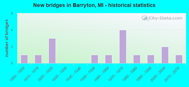
- New bridges - historical statistics
- 11900-1909
- 11910-1919
- 31920-1929
- 11950-1959
- 11960-1969
- 41970-1979
- 11980-1989
- 11990-1999
- 22000-2009
- 12010-2019

- Reconstructed bridges - Historical Statistics
- 11960-1969
- 11970-1979
- 01980-1989
- 31990-1999
- 22000-2009


- Bridge Condition - Deck
- 18.8%Very good
- 25.0%Good
- 43.8%Satisfactory
- 6.3%Fair
- 6.3%Poor

- Bridge Condition - Superstructure
- 25.0%Very good
- 25.0%Good
- 18.8%Satisfactory
- 25.0%Fair
- 6.3%Serious

- Bridge Condition - Substructure
- 18.8%Very good
- 25.0%Good
- 37.5%Satisfactory
- 18.8%Fair

- Bridge Condition - Channel
- 26.7%Very good
- 20.0%Good
- 46.7%Satisfactory
- 6.7%Fair
Find on map >> Show street view
Structure Number: 6753, Location: IN BARRYTON (Lat: 43.746278, Lng: -85.147344), Route carried "on" structure: State highway 66, Year Built: 1927, Year Reconstructed: 1999, Status: Open, Structure Length: 1.53m (5.02ft), Average Daily Traffic: 3,557 (year 2007), Truck Traffic: 6%, Average Future Daily Traffic: 5,104 (year 2018), Design Load: HS 25 or greater, Features Intersected: W BR CHIPPEWA RIVER
Minimum Vertical Clearance: 30.48m (100.00ft), Kilometerpoint: 31.094, Lanes on structure: 2, Base Highway Network: Yes (Inventory Route: 52, Subroute: 7), Owner: State Highway Agency, Approaching Roadway Width: 10.7m (35.1ft), Material/Design: Steel, Design/Construction: Stringer/Multi-beam, Number Of Spans In Main Unit: 1, Length of Maximum Span: 15.3m (50.2ft), Curb-To-Curb Width: 10.7m (35.1ft), Out-to-Out Width: 11.4m (37.4ft)
Condition: Deck: Good, Superstructure: Fair, Substructure: Satisfactory, Channel: Very good, Operating Rating: 92.9 metric tons, Method Used To Determine Operating Rating: Load Factor (LF), Inventory Rating: 55.6 metric tons, Method Used To Determine Inventory Rating: Load Factor (LF), Structural Evaluation: Somewhat better than minimum adequacy, Deck Geometry: Somewhat better than minimum adequacy, Waterway Adequacy: Equal to present desirable criteria, Approach Roadway Alignment: Equal to present desirable criteria, Designated Inspection Frequency: Every 24 months, Inspection Date: August 2020, Deck Structure Type: Concrete Cast-file-Place, Wearing Surface/Protective System: Wearing Surface: Monolithic Concrete, Deck Protection: Epoxy Coated Reinforcing
Find on map >> Show street view
Structure Number: 6754, Location: IN BARRYTON (Lat: 43.753669, Lng: -85.147614), Route carried "on" structure: State highway 66, Year Built: 1927, Year Reconstructed: 1999, Status: Open, Structure Length: 2.45m (8.04ft), Average Daily Traffic: 2,357 (year 2007), Truck Traffic: 9%, Average Future Daily Traffic: 3,492 (year 2018), Design Load: HS 25 or greater, Features Intersected: N BR CHIPPEWA RIVER
Minimum Vertical Clearance: 30.48m (100.00ft), Kilometerpoint: 31.908, Lanes on structure: 2, Base Highway Network: Yes (Inventory Route: 52, Subroute: 7), Owner: State Highway Agency, Approaching Roadway Width: 7.3m (24.0ft), Skew: 1 degrees, Material/Design: Steel, Design/Construction: Stringer/Multi-beam, Number Of Spans In Main Unit: 2, Length of Maximum Span: 12.3m (40.4ft), Curb-To-Curb Width: 10.7m (35.1ft), Out-to-Out Width: 11.4m (37.4ft)
Condition: Deck: Satisfactory, Superstructure: Good, Substructure: Fair, Channel: Good, Operating Rating: 99.5 metric tons, Method Used To Determine Operating Rating: Load Factor (LF), Inventory Rating: 59.6 metric tons, Method Used To Determine Inventory Rating: Load Factor (LF), Structural Evaluation: Somewhat better than minimum adequacy, Deck Geometry: Somewhat better than minimum adequacy, Waterway Adequacy: Equal to present desirable criteria, Approach Roadway Alignment: Equal to present desirable criteria, Designated Inspection Frequency: Every 24 months, Inspection Date: August 2020, Deck Structure Type: Concrete Cast-file-Place, Wearing Surface/Protective System: Wearing Surface: Monolithic Concrete, Deck Protection: Epoxy Coated Reinforcing
Find on map >> Show street view
Structure Number: 6755, Location: 1.0 MI N OF BARRYTON (Lat: 43.761728, Lng: -85.147853), Route carried "on" structure: State highway 66, Year Built: 1927, Year Reconstructed: 1999, Status: Open, Structure Length: 2.43m (7.97ft), Average Daily Traffic: 2,294 (year 2007), Truck Traffic: 9%, Average Future Daily Traffic: 3,469 (year 2018), Design Load: HS 25 or greater, Features Intersected: N BR CHIPPEWA RIVER
Minimum Vertical Clearance: 30.48m (100.00ft), Kilometerpoint: 32.780, Lanes on structure: 2, Base Highway Network: Yes (Inventory Route: 52, Subroute: 7), Owner: State Highway Agency, Approaching Roadway Width: 10.7m (35.1ft), Skew: 4 degrees, Material/Design: Steel, Design/Construction: Stringer/Multi-beam, Number Of Spans In Main Unit: 2, Length of Maximum Span: 12.2m (40.0ft), Curb-To-Curb Width: 10.7m (35.1ft), Out-to-Out Width: 11.4m (37.4ft)
Condition: Deck: Satisfactory, Superstructure: Fair, Substructure: Satisfactory, Channel: Satisfactory, Inventory Rating: 62.2 metric tons, Method Used To Determine Inventory Rating: Load Factor (LF), Structural Evaluation: Somewhat better than minimum adequacy, Deck Geometry: Somewhat better than minimum adequacy, Waterway Adequacy: Equal to present desirable criteria, Approach Roadway Alignment: Equal to present desirable criteria, Designated Inspection Frequency: Every 24 months, Inspection Date: August 2020, Deck Structure Type: Concrete Cast-file-Place, Wearing Surface/Protective System: Wearing Surface: Monolithic Concrete, Deck Protection: Epoxy Coated Reinforcing
Find on map >> Show street view
Structure Number: 6764, Location: BARRYTON MICH (Lat: 43.755911, Lng: -85.148706), Route carried "on" structure: County highway 5480, Year Built: 1956, Year Reconstructed: 2013, Status: Open, Structure Length: 1.36m (4.46ft), Average Daily Traffic: 1,943 (year 2020), Truck Traffic: 5%, Average Future Daily Traffic: 2,146 (year 2040), Design Load: Greater than HL93, Features Intersected: N BR CHIPPEWA RIVER, Facility Carried by Structure: 20 MILE ROAD
Minimum Vertical Clearance: 30.48m (100.00ft), Kilometerpoint: 10.550, Lanes on structure: 2, Base Highway Network: Yes (Inventory Route: 53, Subroute: 7), Owner: County Highway Agency, Approaching Roadway Width: 10.7m (35.1ft), Material/Design: Prestressed concrete, Design/Construction: Box Beam or Girders - Multiple, Number Of Spans In Main Unit: 1, Length of Maximum Span: 13.2m (43.3ft), Curb-To-Curb Width: 10.8m (35.4ft), Out-to-Out Width: 11.5m (37.7ft)
Condition: Deck: Very good, Superstructure: Very good, Substructure: Good, Channel: Good, Operating Rating: 84.9 metric tons, Method Used To Determine Operating Rating: Load and Resistance Factor Rating (LRFR) rating reported by rating factor(RF) method using HL-93 loadings, Inventory Rating: 65.4 metric tons, Method Used To Determine Inventory Rating: Load and Resistance Factor Rating (LRFR) rating reported by rating factor(RF) method using HL-93 loadings, Structural Evaluation: Better than present minimum criteria, Deck Geometry: Equal to present minimum criteria, Waterway Adequacy: Equal to present desirable criteria, Approach Roadway Alignment: Equal to present desirable criteria, Designated Inspection Frequency: Every 24 months, Inspection Date: August 2021, Deck Structure Type: Concrete Cast-file-Place, Wearing Surface/Protective System: Wearing Surface: Monolithic Concrete, Deck Protection: Epoxy Coated Reinforcing
Find on map >> Show street view
Structure Number: 677, Location: 1.4 MI W OF M-66 (Lat: 43.727081, Lng: -85.175036), Route carried "on" structure: County highway , Year Built: 1910, Year Reconstructed: 1974, Status: Posted for load, Structure Length: 0.85m (2.79ft), Average Daily Traffic: 421 (year 2015), Truck Traffic: 9%, Average Future Daily Traffic: 514 (year 2035), Design Load: HS 20, Features Intersected: S BR CHIPPEWA RIVER, Facility Carried by Structure: 18 MILE ROAD
Minimum Vertical Clearance: 30.48m (100.00ft), Kilometerpoint: 2.939, Lanes on structure: 2, Owner: County Highway Agency, Approaching Roadway Width: 6.4m (21.0ft), Material/Design: Steel, Design/Construction: Stringer/Multi-beam, Number Of Spans In Main Unit: 1, Length of Maximum Span: 8.2m (26.9ft), Curb-To-Curb Width: 8.5m (27.9ft), Out-to-Out Width: 8.5m (27.9ft)
Condition: Deck: Poor, Superstructure: Serious, Substructure: Fair, Channel: Satisfactory, Operating Rating: 31.4 metric tons, Method Used To Determine Operating Rating: Load Factor (LF) rating reported by rating factor (RF) method using MS18 loading, Inventory Rating: 18.8 metric tons, Method Used To Determine Inventory Rating: Load Factor (LF) rating reported by rating factor (RF) method using MS18 loading, Structural Evaluation: High priority of corrective action, Deck Geometry: Somewhat better than minimum adequacy, Waterway Adequacy: Equal to present minimum criteria, Approach Roadway Alignment: Equal to present desirable criteria, Bridge Posting: Required (Relationship of Operating Rating to Maximum Legal Load: 10.0 - 19.9% below), Designated Inspection Frequency: Every 12 months, Inspection Date: August 2021, Deck Structure Type: Concrete Cast-file-Place, Wearing Surface/Protective System: Wearing Surface: Bituminous
Find on map >> Show street view
Structure Number: 6771, Location: 0.9 MI W OF M-66 (Lat: 43.741553, Lng: -85.163125), Route carried "on" structure: County highway , Year Built: 1974, Status: Posted for load, Structure Length: 0.91m (2.99ft), Average Daily Traffic: 438 (year 2020), Truck Traffic: 5%, Average Future Daily Traffic: 484 (year 2040), Design Load: HS 20, Features Intersected: S BRANCH CHIPPEWA RIVER, Facility Carried by Structure: 19 MILE ROAD
Minimum Vertical Clearance: 30.48m (100.00ft), Kilometerpoint: 10.540, Lanes on structure: 2, Owner: County Highway Agency, Approaching Roadway Width: 6.1m (20.0ft), Material/Design: Wood or Timber, Design/Construction: Slab, Number Of Spans In Main Unit: 1, Length of Maximum Span: 8.8m (28.9ft), Curb-To-Curb Width: 8.6m (28.2ft), Out-to-Out Width: 9.1m (29.9ft)
Condition: Deck: Fair, Superstructure: Fair, Substructure: Satisfactory, Channel: Satisfactory, Operating Rating: 29.8 metric tons, Method Used To Determine Operating Rating: Allowable Stress (AS) rating reported by rating factor (RF) method using MS18 loading, Inventory Rating: 18.1 metric tons, Method Used To Determine Inventory Rating: Allowable Stress (AS) rating reported by rating factor (RF) method using MS18 loading, Structural Evaluation: Somewhat better than minimum adequacy, Deck Geometry: Somewhat better than minimum adequacy, Waterway Adequacy: Better than present minimum criteria, Approach Roadway Alignment: Equal to present desirable criteria, Bridge Posting: Required (Relationship of Operating Rating to Maximum Legal Load: 30.0 - 39.9% below), Length Of Structure Improvement: 0.91m (2.99ft), Designated Inspection Frequency: Every 24 months, Inspection Date: August 2021, Bridge Improvement Cost: $110,000, Roadway Improvement Cost: $11,000, Total Project Cost: $129,000, Deck Structure Type: Wood or Timber, Wearing Surface/Protective System: Wearing Surface: Bituminous
Find on map >> Show street view
Structure Number: 6772, Location: 2.2 MI E OF M-66 (Lat: 43.741072, Lng: -85.103464), Route carried "on" structure: County highway , Year Built: 1974, Status: Posted for load, Structure Length: 2.39m (7.84ft), Average Daily Traffic: 224 (year 2020), Truck Traffic: 7%, Average Future Daily Traffic: 260 (year 2040), Design Load: HS 20, Features Intersected: CHIPPEWA RIVER, Facility Carried by Structure: 19 MILE ROAD
Minimum Vertical Clearance: 30.48m (100.00ft), Kilometerpoint: 15.565, Lanes on structure: 2, Owner: County Highway Agency, Approaching Roadway Width: 7.0m (23.0ft), Material/Design: Wood or Timber, Design/Construction: Slab, Number Of Spans In Main Unit: 3, Length of Maximum Span: 7.9m (25.9ft), Curb-To-Curb Width: 9.2m (30.2ft), Out-to-Out Width: 9.7m (31.8ft)
Condition: Deck: Satisfactory, Superstructure: Satisfactory, Substructure: Satisfactory, Channel: Satisfactory, Operating Rating: 30.8 metric tons, Method Used To Determine Operating Rating: Allowable Stress (AS) rating reported by rating factor (RF) method using MS18 loading, Inventory Rating: 20.4 metric tons, Method Used To Determine Inventory Rating: Allowable Stress (AS) rating reported by rating factor (RF) method using MS18 loading, Structural Evaluation: Somewhat better than minimum adequacy, Deck Geometry: Equal to present minimum criteria, Waterway Adequacy: Equal to present desirable criteria, Approach Roadway Alignment: Equal to present desirable criteria, Bridge Posting: Required (Relationship of Operating Rating to Maximum Legal Load: 30.0 - 39.9% below), Length Of Structure Improvement: 2.44m (8.01ft), Designated Inspection Frequency: Every 24 months, Inspection Date: August 2021, Bridge Improvement Cost: $210,000, Roadway Improvement Cost: $21,000, Total Project Cost: $247,000, Deck Structure Type: Wood or Timber, Wearing Surface/Protective System: Wearing Surface: Bituminous
Find on map >> Show street view
Structure Number: 6773, Location: 0.8 MI E OF M-66 (Lat: 43.777458, Lng: -85.132847), Route carried "on" structure: County highway , Year Built: 2004, Status: Open, Structure Length: 1.58m (5.18ft), Average Daily Traffic: 71 (year 2015), Truck Traffic: 10%, Average Future Daily Traffic: 87 (year 2035), Design Load: HS 20, Features Intersected: N BR CHIPPEWA RIVER, Facility Carried by Structure: HOOVER RD
Minimum Vertical Clearance: 30.48m (100.00ft), Kilometerpoint: 5.878, Lanes on structure: 2, Owner: County Highway Agency, Approaching Roadway Width: 8.5m (27.9ft), Material/Design: Wood or Timber, Design/Construction: Stringer/Multi-beam, Number Of Spans In Main Unit: 1, Length of Maximum Span: 15.2m (49.9ft), Curb-To-Curb Width: 8.5m (27.9ft), Out-to-Out Width: 9.1m (29.9ft)
Condition: Deck: Good, Superstructure: Good, Substructure: Very good, Channel: Satisfactory, Operating Rating: 41.5 metric tons, Method Used To Determine Operating Rating: Load and Resistance Factor Rating (LRFR) rating reported by rating factor(RF) method using HL-93 loadings, Inventory Rating: 28.8 metric tons, Method Used To Determine Inventory Rating: Load and Resistance Factor Rating (LRFR) rating reported by rating factor(RF) method using HL-93 loadings, Structural Evaluation: Better than present minimum criteria, Deck Geometry: Better than present minimum criteria, Waterway Adequacy: Equal to present minimum criteria, Approach Roadway Alignment: Equal to present desirable criteria, Designated Inspection Frequency: Every 24 months, Inspection Date: August 2021, Deck Structure Type: Wood or Timber, Wearing Surface/Protective System: Wearing Surface: Bituminous
Find on map >> Show street view
Structure Number: 6774, Location: 1.0 MI E OF M-66 (Lat: 43.784614, Lng: -85.126706), Route carried "on" structure: County highway , Year Built: 1900, Year Reconstructed: 1984, Status: Posted for load, Structure Length: 0.91m (2.99ft), Average Daily Traffic: 67 (year 2019), Truck Traffic: 6%, Average Future Daily Traffic: 78 (year 2039), Design Load: HS 20, Features Intersected: N BR CHIPPEWA RIVER, Facility Carried by Structure: 22 MILE RD
Minimum Vertical Clearance: 30.48m (100.00ft), Kilometerpoint: 1.761, Lanes on structure: 2, Owner: County Highway Agency, Approaching Roadway Width: 4.9m (16.1ft), Material/Design: Wood or Timber, Design/Construction: Slab, Number Of Spans In Main Unit: 1, Length of Maximum Span: 8.8m (28.9ft), Curb-To-Curb Width: 5.6m (18.4ft), Out-to-Out Width: 6.0m (19.7ft)
Condition: Deck: Satisfactory, Superstructure: Satisfactory, Substructure: Fair, Channel: Fair, Operating Rating: 38.2 metric tons, Method Used To Determine Operating Rating: Allowable Stress (AS) rating reported by rating factor (RF) method using MS18 loading, Inventory Rating: 25.9 metric tons, Method Used To Determine Inventory Rating: Allowable Stress (AS) rating reported by rating factor (RF) method using MS18 loading, Structural Evaluation: Somewhat better than minimum adequacy, Deck Geometry: Meets minimum limits, Waterway Adequacy: Better than present minimum criteria, Approach Roadway Alignment: Equal to present desirable criteria, Bridge Posting: Required (Relationship of Operating Rating to Maximum Legal Load: 20.0 - 29.9% below), Designated Inspection Frequency: Every 24 months, Inspection Date: August 2021, Deck Structure Type: Wood or Timber, Wearing Surface/Protective System: Wearing Surface: Bituminous
Find on map >> Show street view
Structure Number: 6775, Location: 1.0 MI E OF M-66 (Lat: 43.806303, Lng: -85.128042), Route carried "on" structure: County highway , Year Built: 2008, Status: Open, Structure Length: 1.58m (5.18ft), Average Daily Traffic: 64 (year 2020), Truck Traffic: 10%, Average Future Daily Traffic: 74 (year 2040), Design Load: HS 20, Features Intersected: N BR CHIPPEWA RIVER, Facility Carried by Structure: EVERGREEN ROAD
Minimum Vertical Clearance: 30.48m (100.00ft), Kilometerpoint: 1.663, Lanes on structure: 2, Owner: County Highway Agency, Approaching Roadway Width: 8.5m (27.9ft), Material/Design: Wood or Timber, Design/Construction: Stringer/Multi-beam, Number Of Spans In Main Unit: 1, Length of Maximum Span: 15.2m (49.9ft), Curb-To-Curb Width: 8.5m (27.9ft), Out-to-Out Width: 9.1m (29.9ft)
Condition: Deck: Good, Superstructure: Very good, Substructure: Very good, Channel: Good, Operating Rating: 41.5 metric tons, Method Used To Determine Operating Rating: Load and Resistance Factor Rating (LRFR) rating reported by rating factor(RF) method using HL-93 loadings, Inventory Rating: 28.8 metric tons, Method Used To Determine Inventory Rating: Load and Resistance Factor Rating (LRFR) rating reported by rating factor(RF) method using HL-93 loadings, Structural Evaluation: Better than present minimum criteria, Deck Geometry: Better than present minimum criteria, Waterway Adequacy: Better than present minimum criteria, Approach Roadway Alignment: Equal to present desirable criteria, Designated Inspection Frequency: Every 24 months, Inspection Date: August 2021, Deck Structure Type: Wood or Timber, Wearing Surface/Protective System: Wearing Surface: Bituminous
Find on map >> Show street view
Structure Number: 6776, Location: 0.8 MI S OF 20 MILE RD (Lat: 43.745258, Lng: -85.157397), Route carried "on" structure: County highway , Year Built: 1996, Status: Posted for load, Structure Length: 2.31m (7.58ft), Average Daily Traffic: 55 (year 2019), Average Future Daily Traffic: 67 (year 2039), Design Load: HS 20, Features Intersected: W BR CHIPPEWA RIVER, Facility Carried by Structure: 35TH AVENUE
Minimum Vertical Clearance: 30.48m (100.00ft), Kilometerpoint: 1.189, Lanes on structure: 2, Owner: County Highway Agency, Approaching Roadway Width: 6.7m (22.0ft), Material/Design: Wood or Timber, Design/Construction: Slab, Number Of Spans In Main Unit: 3, Length of Maximum Span: 9.8m (32.2ft), Curb-To-Curb Width: 8.7m (28.5ft), Out-to-Out Width: 9.1m (29.9ft)
Condition: Deck: Good, Superstructure: Good, Substructure: Good, Channel: Very good, Operating Rating: 46.0 metric tons, Method Used To Determine Operating Rating: Allowable Stress (AS) rating reported by rating factor (RF) method using MS18 loading, Inventory Rating: 31.4 metric tons, Method Used To Determine Inventory Rating: Allowable Stress (AS) rating reported by rating factor (RF) method using MS18 loading, Structural Evaluation: Better than present minimum criteria, Deck Geometry: Better than present minimum criteria, Waterway Adequacy: Equal to present desirable criteria, Approach Roadway Alignment: Meets minimum limits, Bridge Posting: Required (Relationship of Operating Rating to Maximum Legal Load: 0.1 - 9.9% below), Designated Inspection Frequency: Every 24 months, Inspection Date: August 2021, Deck Structure Type: Wood or Timber, Wearing Surface/Protective System: Wearing Surface: Bituminous
Find on map >> Show street view
Structure Number: 6777, Location: 0.1 MI N OF 19 MILE ROAD (Lat: 43.740558, Lng: -85.127425), Route carried "on" structure: County highway , Year Built: 2018, Status: Open, Structure Length: 2.32m (7.61ft), Average Daily Traffic: 160 (year 2019), Truck Traffic: 4%, Average Future Daily Traffic: 195 (year 2039), Design Load: Greater than HL93, Features Intersected: CHIPPEWA RIVER, Facility Carried by Structure: 20TH AVE
Minimum Vertical Clearance: 30.48m (100.00ft), Kilometerpoint: 5.618, Lanes on structure: 2, Owner: County Highway Agency, Approaching Roadway Width: 7.6m (24.9ft), Skew: 1 degrees, Material/Design: Prestressed concrete, Design/Construction: Box Beam or Girders - Multiple, Number Of Spans In Main Unit: 1, Length of Maximum Span: 22.8m (74.8ft), Curb-To-Curb Width: 7.8m (25.6ft), Out-to-Out Width: 8.7m (28.5ft)
Condition: Deck: Very good, Superstructure: Very good, Substructure: Very good, Channel: Very good, Operating Rating: 80.0 metric tons, Method Used To Determine Operating Rating: Load and Resistance Factor Rating (LRFR) rating reported by rating factor(RF) method using HL-93 loadings, Inventory Rating: 61.9 metric tons, Method Used To Determine Inventory Rating: Load and Resistance Factor Rating (LRFR) rating reported by rating factor(RF) method using HL-93 loadings, Structural Evaluation: Equal to present desirable criteria, Deck Geometry: Somewhat better than minimum adequacy, Waterway Adequacy: Better than present minimum criteria, Approach Roadway Alignment: Equal to present desirable criteria, Designated Inspection Frequency: Every 24 months, Inspection Date: August 2021, Deck Structure Type: Concrete Cast-file-Place, Wearing Surface/Protective System: Wearing Surface: Monolithic Concrete, Deck Protection: Epoxy Coated Reinforcing
Find on map >> Show street view
Structure Number: 6778, Location: 0.3 MI S OF 20 MILE ROAD (Lat: 43.749961, Lng: -85.108275), Route carried "on" structure: County highway , Year Built: 1975, Status: Posted for load, Structure Length: 3.19m (10.47ft), Average Daily Traffic: 223 (year 2019), Truck Traffic: 9%, Average Future Daily Traffic: 259 (year 2039), Design Load: HS 20, Features Intersected: CHIPPEWA RIVER, Facility Carried by Structure: 10TH AVE
Minimum Vertical Clearance: 30.48m (100.00ft), Kilometerpoint: 9.936, Lanes on structure: 2, Owner: County Highway Agency, Approaching Roadway Width: 6.1m (20.0ft), Material/Design: Wood or Timber, Design/Construction: Slab, Number Of Spans In Main Unit: 4, Length of Maximum Span: 7.9m (25.9ft), Curb-To-Curb Width: 9.1m (29.9ft), Out-to-Out Width: 9.8m (32.2ft)
Condition: Deck: Satisfactory, Superstructure: Satisfactory, Substructure: Satisfactory, Channel: Satisfactory, Operating Rating: 35.6 metric tons, Method Used To Determine Operating Rating: Allowable Stress (AS) rating reported by rating factor (RF) method using MS18 loading, Inventory Rating: 23.3 metric tons, Method Used To Determine Inventory Rating: Allowable Stress (AS) rating reported by rating factor (RF) method using MS18 loading, Structural Evaluation: Equal to present minimum criteria, Deck Geometry: Equal to present minimum criteria, Waterway Adequacy: Equal to present desirable criteria, Approach Roadway Alignment: Somewhat better than minimum adequacy, Bridge Posting: Required (Relationship of Operating Rating to Maximum Legal Load: 20.0 - 29.9% below), Length Of Structure Improvement: 3.66m (12.01ft), Designated Inspection Frequency: Every 24 months, Inspection Date: August 2021, Bridge Improvement Cost: $220,000, Roadway Improvement Cost: $22,000, Total Project Cost: $259,000, Deck Structure Type: Wood or Timber, Wearing Surface/Protective System: Wearing Surface: Wood or Timber
Find on map >> Show street view
Structure Number: 6783, Location: 0.4 E OF M-66 (Lat: 43.748697, Lng: -85.139161), Route carried "on" structure: City street , Year Built: 1989, Status: Open, Structure Length: 2.74m (8.99ft), Average Daily Traffic: 450 (year 2014), Truck Traffic: 5%, Average Future Daily Traffic: 812 (year 2034), Design Load: HS 20, Features Intersected: CHIPPEWA RIVER, Facility Carried by Structure: MARION AVE
Minimum Vertical Clearance: 30.48m (100.00ft), Kilometerpoint: 0.650, Lanes on structure: 2, Owner: City or Municipal Highway Agency, Approaching Roadway Width: 10.4m (34.1ft), Material/Design: Prestressed concrete, Design/Construction: Tee Beam, Number Of Spans In Main Unit: 3, Length of Maximum Span: 9.1m (29.9ft), Curb or Sidewalk Widths: Left: 0.0m, Right: 1.5m (4.9ft), Curb-To-Curb Width: 9.1m (29.9ft), Out-to-Out Width: 9.2m (30.2ft)
Condition: Deck: Satisfactory, Superstructure: Fair, Substructure: Good, Channel: Very good, Operating Rating: 55.7 metric tons, Method Used To Determine Operating Rating: Load Factor (LF) rating reported by rating factor (RF) method using MS18 loading, Inventory Rating: 33.4 metric tons, Method Used To Determine Inventory Rating: Load Factor (LF) rating reported by rating factor (RF) method using MS18 loading, Structural Evaluation: Somewhat better than minimum adequacy, Deck Geometry: Equal to present minimum criteria, Waterway Adequacy: Equal to present desirable criteria, Approach Roadway Alignment: Equal to present minimum criteria, Designated Inspection Frequency: Every 24 months, Inspection Date: June 2020, Deck Structure Type: Concrete Cast-file-Place, Wearing Surface/Protective System: Wearing Surface: Bituminous, Membrane: Other, Deck Protection: Epoxy Coated Reinforcing
Find on map >> Show street view
Structure Number: 8795, Location: AT SE LIMITS OF NUNICA (Lat: 43.074242, Lng: -86.081714), Route carried "on" structure: Interstate 96, Year Built: 1961, Year Reconstructed: 2013, Status: Open, Structure Length: 6.18m (20.28ft), Average Daily Traffic: 23,300 (year 2013), Truck Traffic: 7%, Average Future Daily Traffic: 28,400 (year 2033), Design Load: HS 20+Mod, Features Intersected: M-104
Minimum Vertical Clearance: 30.48m (100.00ft), Kilometerpoint: 6.212, Lanes on structure: 2, Lanes under structure: 3, Base Highway Network: Yes (Inventory Route: 74, Subroute: 10), Owner: State Highway Agency, Approaching Roadway Width: 12.8m (42.0ft), Skew: 4 degrees, Material/Design: Steel, Design/Construction: Stringer/Multi-beam, Number Of Spans In Main Unit: 3, Length of Maximum Span: 25.4m (83.3ft), Curb-To-Curb Width: 12.5m (41.0ft), Out-to-Out Width: 13.5m (44.3ft)
Condition: Deck: Satisfactory, Superstructure: Good, Substructure: Satisfactory, Operating Rating: 77.4 metric tons, Method Used To Determine Operating Rating: Load Factor (LF) rating reported by rating factor (RF) method using MS18 loading, Inventory Rating: 46.3 metric tons, Method Used To Determine Inventory Rating: Load Factor (LF) rating reported by rating factor (RF) method using MS18 loading, Structural Evaluation: Equal to present minimum criteria, Deck Geometry: Better than present minimum criteria, Underclear: Meets minimum limits, Approach Roadway Alignment: Equal to present desirable criteria, Designated Inspection Frequency: Every 24 months, Inspection Date: May 2020, Deck Structure Type: Concrete Cast-file-Place, Wearing Surface/Protective System: Wearing Surface: Latex Concrete
Find on map >> Show street view
Structure Number: 8801, Location: 0.75 MILES E OF 152ND AVE (Lat: 42.797617, Lng: -86.142603), Route carried "on" structure: County highway 2014, Year Built: 1974, Status: Open, Structure Length: 1.43m (4.69ft), Average Daily Traffic: 13,600 (year 2021), Truck Traffic: 3%, Average Future Daily Traffic: 24,600 (year 2041), Design Load: HS 20, Features Intersected: PINE CREEK, Facility Carried by Structure: OTTAWA BEACH DRIVE
Minimum Vertical Clearance: 30.48m (100.00ft), Kilometerpoint: 6.581, Lanes on structure: 4, Owner: County Highway Agency, Approaching Roadway Width: 15.9m (52.2ft), Skew: 3 degrees, Material/Design: Prestressed concrete, Design/Construction: Box Beam or Girders - Multiple, Number Of Spans In Main Unit: 1, Length of Maximum Span: 13.7m (44.9ft), Curb or Sidewalk Widths: Left: 1.5m (4.9ft), Right: 1.5m (4.9ft), Curb-To-Curb Width: 15.5m (50.9ft), Out-to-Out Width: 19.3m (63.3ft)
Condition: Deck: Very good, Superstructure: Very good, Substructure: Good, Channel: Satisfactory, Operating Rating: 48.0 metric tons, Method Used To Determine Operating Rating: Load and Resistance Factor Rating (LRFR) rating reported by rating factor(RF) method using HL-93 loadings, Inventory Rating: 36.9 metric tons, Method Used To Determine Inventory Rating: Load and Resistance Factor Rating (LRFR) rating reported by rating factor(RF) method using HL-93 loadings, Structural Evaluation: Better than present minimum criteria, Deck Geometry: Meets minimum limits, Waterway Adequacy: Equal to present desirable criteria, Approach Roadway Alignment: Equal to present desirable criteria, Designated Inspection Frequency: Every 24 months, Inspection Date: September 2020, Deck Structure Type: Concrete Precast Panels, Wearing Surface/Protective System: Wearing Surface: Bituminous, Membrane: Preformed Fabric