Bridge Statistics for Barre, Wisconsin (WI)
Condition, Traffic, Stress, Structural Evaluation, Project Costs
- National Bridge Inventory (NBI) Statistics
- 10Number of bridges
- 56ft / 17.0mTotal length
- $1,007,000Total costs
- 16,475Total average daily traffic
- 17,843Total future (year 2039) average daily traffic
- National Bridge Inventory (NBI) Registered Bridges for Barre
- No street view available for this location
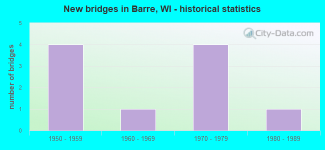
- New bridges - historical statistics
- 41950-1959
- 11960-1969
- 41970-1979
- 11980-1989


- Bridge Condition - Deck
- 50.0%Satisfactory
- 50.0%Fair

- Bridge Condition - Superstructure
- 12.5%Very good
- 37.5%Satisfactory
- 37.5%Fair
- 12.5%Poor

- Bridge Condition - Substructure
- 12.5%Good
- 25.0%Satisfactory
- 50.0%Fair
- 12.5%Poor

- Bridge Condition - Channel
- 50.0%Very good
- 20.0%Good
- 30.0%Satisfactory

- Bridge Condition - Culverts
- 50.0%Satisfactory
- 50.0%Fair
Find on map >> Show street view
Structure Number: B320001, Location: 0.2M E JCT CTH D (Lat: 43.967717, Lng: -91.202583), Route carried "on" structure: County highway , Year Built: 1952, Status: Open, Structure Length: 1.26m (4.13ft), Average Daily Traffic: 1,530 (year 2019), Average Future Daily Traffic: 1,683 (year 2040), Design Load: H 15, Features Intersected: JOHNSON COULEE CREEK, Facility Carried by Structure: CTH W
Minimum Vertical Clearance: 30+ m (98+ ft), Kilometerpoint: 0.000, Lanes on structure: 2, Owner: County Highway Agency, Approaching Roadway Width: 8.5m (27.9ft), Material/Design: Steel, Design/Construction: Stringer/Multi-beam, Number Of Spans In Main Unit: 1, Length of Maximum Span: 12.6m (41.3ft), Curb-To-Curb Width: 7.3m (24.0ft), Out-to-Out Width: 8.0m (26.2ft)
Condition: Deck: Satisfactory, Superstructure: Fair, Substructure: Satisfactory, Channel: Very good, Operating Rating: 35.9 metric tons, Method Used To Determine Operating Rating: Load Factor (LF), Inventory Rating: 21.1 metric tons, Method Used To Determine Inventory Rating: Load Factor (LF), Structural Evaluation: Somewhat better than minimum adequacy, Deck Geometry: Meets minimum limits, Waterway Adequacy: Equal to present desirable criteria, Approach Roadway Alignment: Equal to present desirable criteria, Designated Inspection Frequency: Every 24 months, Inspection Date: March 2021, Deck Structure Type: Concrete Cast-file-Place, Wearing Surface/Protective System: Wearing Surface: Bituminous
Find on map >> Show street view
Structure Number: B320007, Location: 0.3M N JCT CTH I (Lat: 43.829517, Lng: -91.061200), Route carried "on" structure: County highway , Year Built: 1952, Status: Open, Structure Length: 2.23m (7.32ft), Average Daily Traffic: 2,856 (year 2019), Average Future Daily Traffic: 3,141 (year 2040), Design Load: H 15, Features Intersected: BOSTWICK CREEK, Facility Carried by Structure: CTH M
Minimum Vertical Clearance: 30+ m (98+ ft), Kilometerpoint: 0.000, Lanes on structure: 2, Owner: County Highway Agency, Approaching Roadway Width: 8.5m (27.9ft), Material/Design: Steel, Design/Construction: Stringer/Multi-beam, Number Of Spans In Main Unit: 1, Length of Maximum Span: 21.7m (71.2ft), Curb-To-Curb Width: 7.3m (24.0ft), Out-to-Out Width: 8.0m (26.2ft)
Condition: Deck: Fair, Superstructure: Fair, Substructure: Fair, Channel: Good, Operating Rating: 31.0 metric tons, Method Used To Determine Operating Rating: Load Factor (LF), Inventory Rating: 17.8 metric tons, Method Used To Determine Inventory Rating: Load Factor (LF), Structural Evaluation: Meets minimum limits, Deck Geometry: High priority of replacement, Waterway Adequacy: Equal to present desirable criteria, Approach Roadway Alignment: Equal to present desirable criteria, Length Of Structure Improvement: 2.68m (8.79ft), Designated Inspection Frequency: Every 24 months, Inspection Date: April 2021, Bridge Improvement Cost: $285,000, Roadway Improvement Cost: $28,000, Total Project Cost: $427,000 ( Estimate for 2021), Deck Structure Type: Concrete Cast-file-Place, Wearing Surface/Protective System: Wearing Surface: Bituminous
Find on map >> Show street view
Structure Number: B320014, Location: 1.1M E JCT CTH YY (Lat: 43.834100, Lng: -91.075183), Route carried "on" structure: County highway , Year Built: 1952, Status: Open, Structure Length: 1.90m (6.23ft), Average Daily Traffic: 2,448 (year 2019), Average Future Daily Traffic: 2,692 (year 2040), Design Load: H 15, Features Intersected: RUSSIAN COULEE CREEK, Facility Carried by Structure: CTH M
Minimum Vertical Clearance: 30+ m (98+ ft), Kilometerpoint: 0.000, Lanes on structure: 2, Owner: County Highway Agency, Approaching Roadway Width: 8.5m (27.9ft), Skew: 3 degrees, Material/Design: Steel, Design/Construction: Stringer/Multi-beam, Number Of Spans In Main Unit: 1, Length of Maximum Span: 18.7m (61.4ft), Curb-To-Curb Width: 7.3m (24.0ft), Out-to-Out Width: 8.0m (26.2ft)
Condition: Deck: Satisfactory, Superstructure: Satisfactory, Substructure: Satisfactory, Channel: Very good, Operating Rating: 26.1 metric tons, Method Used To Determine Operating Rating: Load Factor (LF), Inventory Rating: 14.6 metric tons, Method Used To Determine Inventory Rating: Load Factor (LF), Structural Evaluation: Meets minimum limits, Deck Geometry: High priority of replacement, Waterway Adequacy: Equal to present desirable criteria, Approach Roadway Alignment: Equal to present desirable criteria, Length Of Structure Improvement: 2.35m (7.71ft), Designated Inspection Frequency: Every 24 months, Inspection Date: April 2021, Bridge Improvement Cost: $250,000, Roadway Improvement Cost: $25,000, Total Project Cost: $376,000 ( Estimate for 2021), Deck Structure Type: Concrete Cast-file-Place, Wearing Surface/Protective System: Wearing Surface: Bituminous
Find on map >> Show street view
Structure Number: B320022, Location: 1.0M N JCT CTH O (Lat: 43.853583, Lng: -91.104383), Route carried "on" structure: County highway , Year Built: 1958, Status: Open, Structure Length: 0.68m (2.23ft), Average Daily Traffic: 4,080 (year 2019), Average Future Daily Traffic: 4,488 (year 2040), Design Load: H 15, Features Intersected: BR BOSTWICK CREEK, Facility Carried by Structure: CTH M
Minimum Vertical Clearance: 30+ m (98+ ft), Kilometerpoint: 0.000, Lanes on structure: 2, Owner: County Highway Agency, Approaching Roadway Width: 9.1m (29.9ft), Skew: 3 degrees, Material/Design: Concrete continuous, Design/Construction: Culvert, Number Of Spans In Main Unit: 2, Length of Maximum Span: 2.4m (7.9ft)
Condition: Channel: Very good, Culverts: Satisfactory, Operating Rating: 53.9 metric tons, Method Used To Determine Operating Rating: Field evaluation and documented engineering judgment, Inventory Rating: 24.3 metric tons, Method Used To Determine Inventory Rating: Field evaluation and documented engineering judgment, Structural Evaluation: Equal to present minimum criteria, Waterway Adequacy: Equal to present desirable criteria, Approach Roadway Alignment: Equal to present minimum criteria, Designated Inspection Frequency: Every 24 months, Inspection Date: April 2021, Deck Structure Type: Concrete Cast-file-Place, Wearing Surface/Protective System: Wearing Surface: Bituminous
Find on map >> Show street view
Structure Number: B320093, Location: 0.2M W JCT CTH O (Lat: 43.851383, Lng: -91.149917), Route carried "on" structure: County highway , Year Built: 1979, Status: Open, Structure Length: 0.85m (2.79ft), Average Daily Traffic: 3,774 (year 2019), Average Future Daily Traffic: 4,151 (year 2040), Design Load: H 15, Features Intersected: WELLS COULEE, Facility Carried by Structure: CTH B
Minimum Vertical Clearance: 30+ m (98+ ft), Kilometerpoint: 0.000, Lanes on structure: 2, Owner: County Highway Agency, Approaching Roadway Width: 9.8m (32.2ft), Material/Design: Steel, Design/Construction: Culvert, Number Of Spans In Main Unit: 3, Length of Maximum Span: 2.4m (7.9ft)
Condition: Channel: Satisfactory, Culverts: Fair, Operating Rating: 53.9 metric tons, Method Used To Determine Operating Rating: Field evaluation and documented engineering judgment, Inventory Rating: 24.3 metric tons, Method Used To Determine Inventory Rating: Field evaluation and documented engineering judgment, Structural Evaluation: Somewhat better than minimum adequacy, Waterway Adequacy: Equal to present minimum criteria, Approach Roadway Alignment: Equal to present minimum criteria, Designated Inspection Frequency: Every 24 months, Inspection Date: April 2021, Deck Structure Type: Steel plate, Wearing Surface/Protective System: Wearing Surface: Bituminous
Find on map >> Show street view
Structure Number: B320094, Location: 0.8M W JCT CTH M (Lat: 43.856033, Lng: -91.116639), Route carried "on" structure: City street , Year Built: 1982, Status: Open, Structure Length: 2.97m (9.74ft), Average Daily Traffic: 146 (year 2019), Average Future Daily Traffic: 160 (year 2039), Design Load: H 20, Features Intersected: BOSTWICK CREEK, Facility Carried by Structure: LRD SWAMP RD
Minimum Vertical Clearance: 30+ m (98+ ft), Kilometerpoint: 0.000, Lanes on structure: 2, Owner: Town or Township Highway Agency, Approaching Roadway Width: 8.5m (27.9ft), Material/Design: Prestressed concrete, Design/Construction: Stringer/Multi-beam, Number Of Spans In Main Unit: 1, Length of Maximum Span: 29.2m (95.8ft), Curb-To-Curb Width: 7.9m (25.9ft), Out-to-Out Width: 8.5m (27.9ft)
Condition: Deck: Fair, Superstructure: Very good, Substructure: Good, Channel: Good, Operating Rating: 58.8 metric tons, Method Used To Determine Operating Rating: Load Factor (LF), Inventory Rating: 32.4 metric tons, Method Used To Determine Inventory Rating: Load Factor (LF), Structural Evaluation: Better than present minimum criteria, Deck Geometry: Somewhat better than minimum adequacy, Waterway Adequacy: Equal to present desirable criteria, Approach Roadway Alignment: Equal to present desirable criteria, Designated Inspection Frequency: Every 24 months, Inspection Date: March 2020, Deck Structure Type: Concrete Cast-file-Place, Wearing Surface/Protective System: Wearing Surface: Monolithic Concrete
Find on map >> Show street view
Structure Number: P320064, Location: 0.1M E JCT CTH M (Lat: 43.826833, Lng: -91.060517), Route carried "on" structure: County highway , Year Built: 1973, Status: Posted for load, Structure Length: 1.90m (6.23ft), Average Daily Traffic: 448 (year 2019), Average Future Daily Traffic: 492 (year 2040), Design Load: H 20, Features Intersected: BR BOSTWICK CREEK, Facility Carried by Structure: CTH I
Minimum Vertical Clearance: 30+ m (98+ ft), Kilometerpoint: 0.000, Lanes on structure: 2, Owner: County Highway Agency, Approaching Roadway Width: 8.5m (27.9ft), Material/Design: Wood or Timber, Design/Construction: Slab, Number Of Spans In Main Unit: 3, Length of Maximum Span: 7.5m (24.6ft), Curb-To-Curb Width: 9.4m (30.8ft), Out-to-Out Width: 9.8m (32.2ft)
Condition: Deck: Satisfactory, Superstructure: Satisfactory, Substructure: Fair, Channel: Satisfactory, Operating Rating: 41.0 metric tons, Method Used To Determine Operating Rating: Load Factor (LF), Inventory Rating: 27.5 metric tons, Method Used To Determine Inventory Rating: Load Factor (LF), Structural Evaluation: Somewhat better than minimum adequacy, Deck Geometry: Equal to present minimum criteria, Waterway Adequacy: Equal to present desirable criteria, Approach Roadway Alignment: Equal to present desirable criteria, Designated Inspection Frequency: Every 24 months, Inspection Date: April 2021, Deck Structure Type: Wood or Timber, Wearing Surface/Protective System: Wearing Surface: Bituminous
Find on map >> Show street view
Structure Number: P32011, Location: 1.3M S JCT CTH M (Lat: 43.820000, Lng: -91.089194), Route carried "on" structure: County highway , Year Built: 1971, Status: Open, Structure Length: 1.59m (5.22ft), Average Daily Traffic: 913 (year 2019), Average Future Daily Traffic: 1,004 (year 2040), Design Load: H 15, Features Intersected: BR BOSTWICK CREEK, Facility Carried by Structure: CTH YY
Minimum Vertical Clearance: 30+ m (98+ ft), Kilometerpoint: 0.000, Lanes on structure: 2, Owner: County Highway Agency, Approaching Roadway Width: 9.1m (29.9ft), Material/Design: Wood or Timber, Design/Construction: Slab, Number Of Spans In Main Unit: 2, Length of Maximum Span: 7.9m (25.9ft), Curb-To-Curb Width: 9.3m (30.5ft), Out-to-Out Width: 9.7m (31.8ft)
Condition: Deck: Fair, Superstructure: Fair, Substructure: Fair, Channel: Very good, Operating Rating: 52.3 metric tons, Method Used To Determine Operating Rating: Load Factor (LF), Inventory Rating: 35.6 metric tons, Method Used To Determine Inventory Rating: Load Factor (LF), Structural Evaluation: Somewhat better than minimum adequacy, Deck Geometry: Equal to present minimum criteria, Waterway Adequacy: Equal to present desirable criteria, Approach Roadway Alignment: Equal to present desirable criteria, Designated Inspection Frequency: Every 12 months, Inspection Date: April 2021, Deck Structure Type: Wood or Timber, Wearing Surface/Protective System: Wearing Surface: Bituminous
Find on map >> Show street view
Structure Number: P320163, Location: 0.2M W JCT CTH OA (Lat: 43.826917, Lng: -91.114350), Route carried "on" structure: City street , Year Built: 1976, Status: Posted for load, Structure Length: 2.27m (7.45ft), Average Daily Traffic: 240 (year 2018), Average Future Daily Traffic: 21 (year 2040), Design Load: H 15, Features Intersected: GARBERS COULEE CREEK, Facility Carried by Structure: LRD DRECTAH RD (DE
Minimum Vertical Clearance: 30+ m (98+ ft), Kilometerpoint: 0.000, Lanes on structure: 2, Owner: Town or Township Highway Agency, Approaching Roadway Width: 9.1m (29.9ft), Material/Design: Wood or Timber, Design/Construction: Slab, Number Of Spans In Main Unit: 3, Length of Maximum Span: 7.9m (25.9ft), Curb-To-Curb Width: 8.1m (26.6ft), Out-to-Out Width: 8.5m (27.9ft)
Condition: Deck: Satisfactory, Superstructure: Satisfactory, Substructure: Fair, Channel: Very good, Operating Rating: 39.2 metric tons, Method Used To Determine Operating Rating: Load Factor (LF), Inventory Rating: 27.5 metric tons, Method Used To Determine Inventory Rating: Load Factor (LF), Structural Evaluation: Somewhat better than minimum adequacy, Deck Geometry: Somewhat better than minimum adequacy, Waterway Adequacy: Equal to present desirable criteria, Approach Roadway Alignment: Equal to present desirable criteria, Bridge Posting: Required (Relationship of Operating Rating to Maximum Legal Load: 0.1 - 9.9% below), Designated Inspection Frequency: Every 12 months, Inspection Date: March 2021, Deck Structure Type: Wood or Timber, Wearing Surface/Protective System: Wearing Surface: Bituminous
Find on map >> Show street view
Structure Number: P320903, Location: 0.1M N JCT CTH I (Lat: 43.828767, Lng: -91.044917), Route carried "on" structure: City street , Year Built: 1965, Status: Posted for load, Structure Length: 1.32m (4.33ft), Average Daily Traffic: 40 (year 2020), Average Future Daily Traffic: 11 (year 2040), Design Load: H 20, Features Intersected: BOSTWICK CREEK, Facility Carried by Structure: LRD DROGSETH RD (D
Minimum Vertical Clearance: 30+ m (98+ ft), Kilometerpoint: 0.000, Lanes on structure: 1, Owner: Town or Township Highway Agency, Approaching Roadway Width: 4.9m (16.1ft), Material/Design: Steel, Design/Construction: Stringer/Multi-beam, Number Of Spans In Main Unit: 1, Length of Maximum Span: 12.3m (40.4ft), Curb-To-Curb Width: 4.9m (16.1ft), Out-to-Out Width: 5.4m (17.7ft)
Condition: Deck: Fair, Superstructure: Poor, Substructure: Poor, Channel: Satisfactory, Operating Rating: 21.2 metric tons, Method Used To Determine Operating Rating: Load Factor (LF), Inventory Rating: 16.2 metric tons, Method Used To Determine Inventory Rating: Load Factor (LF), Structural Evaluation: Meets minimum limits, Deck Geometry: High priority of corrective action, Waterway Adequacy: Equal to present desirable criteria, Approach Roadway Alignment: Equal to present desirable criteria, Bridge Posting: Required (Relationship of Operating Rating to Maximum Legal Load: 0.1 - 9.9% below), Length Of Structure Improvement: 1.77m (5.81ft), Designated Inspection Frequency: Every 12 months, Inspection Date: March 2021, Bridge Improvement Cost: $136,000, Roadway Improvement Cost: $13,000, Total Project Cost: $204,000 ( Estimate for 2021), Deck Structure Type: Wood or Timber, Wearing Surface/Protective System: Wearing Surface: Bituminous