Bridge Statistics for Barkeyville, Pennsylvania (PA)
Condition, Traffic, Stress, Structural Evaluation, Project Costs
- National Bridge Inventory (NBI) Statistics
- 27Number of bridges
- 105ft / 32.0mTotal length
- $2,233,000Total costs
- 93,582Total average daily traffic
- 24,156Total average daily truck traffic
- National Bridge Inventory (NBI) Registered Bridges for Barkeyville
- No street view available for this location
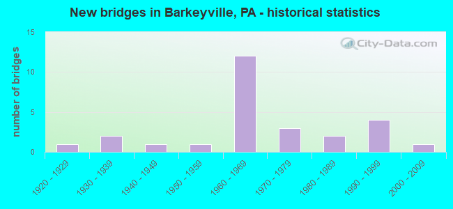
- New bridges - historical statistics
- 11920-1929
- 21930-1939
- 11940-1949
- 11950-1959
- 121960-1969
- 31970-1979
- 21980-1989
- 41990-1999
- 12000-2009

- Reconstructed bridges - Historical Statistics
- 21970-1979
- 01980-1989
- 01990-1999
- 32000-2009
- 02010-2019
- 12020-2022


- Bridge Condition - Deck
- 20.0%Very good
- 20.0%Good
- 46.7%Satisfactory
- 13.3%Fair

- Bridge Condition - Superstructure
- 33.3%Very good
- 6.7%Good
- 20.0%Satisfactory
- 33.3%Fair
- 6.7%Poor

- Bridge Condition - Substructure
- 20.0%Very good
- 40.0%Good
- 20.0%Satisfactory
- 20.0%Fair

- Bridge Condition - Channel
- 16.7%Very good
- 33.3%Good
- 16.7%Satisfactory
- 25.0%Fair
- 8.3%Poor

- Bridge Condition - Culverts
- 33.3%Very good
- 33.3%Good
- 33.3%Satisfactory
Find on map >> Show street view
Structure Number: 8256, Location: 500 FT FROM INT W/T-476 (Lat: 41.152361, Lng: -79.962658), Route carried "on" structure: City street , Year Built: 1940, Year Reconstructed: 1983, Status: Posted for load, Structure Length: 1.10m (3.61ft), Average Daily Traffic: 50 (year 2017), Truck Traffic: 9%, Average Future Daily Traffic: 75 (year 2037), Features Intersected: N BR SLIPPERY ROCK CR, Facility Carried by Structure: T-473 RAY ROAD
Minimum Vertical Clearance: 30+ m (98+ ft), Kilometerpoint: 0.000, Lanes on structure: 1, Owner: Town or Township Highway Agency, Approaching Roadway Width: 3.0m (9.8ft), Material/Design: Steel, Design/Construction: Stringer/Multi-beam, Number Of Spans In Main Unit: 1, Length of Maximum Span: 10.4m (34.1ft), Curb-To-Curb Width: 3.8m (12.5ft), Out-to-Out Width: 4.3m (14.1ft)
Condition: Deck: Fair, Superstructure: Fair, Substructure: Satisfactory, Channel: Fair, Operating Rating: 15.4 metric tons, Method Used To Determine Operating Rating: Load Factor (LF), Inventory Rating: 9.1 metric tons, Method Used To Determine Inventory Rating: Load Factor (LF), Structural Evaluation: High priority of corrective action, Deck Geometry: Meets minimum limits, Waterway Adequacy: Equal to present minimum criteria, Approach Roadway Alignment: Equal to present minimum criteria, Bridge Posting: Required (Relationship of Operating Rating to Maximum Legal Load: > 39.9% below), Length Of Structure Improvement: 1.70m (5.58ft), Designated Inspection Frequency: Every 24 months, Other Special Inspection Frequency: Every 12 months, Inspection Date: August 2021, Other Special Inspection Date: August 2021, Bridge Improvement Cost: $4,000, Roadway Improvement Cost: $10,000, Total Project Cost: $48,000, Deck Structure Type: Open Grating
Find on map >> Show street view
Structure Number: 25953, Location: WOLF CREEK TOWNSHIP (Lat: 41.209125, Lng: -80.038214), Route carried "on" structure: State highway , Year Built: 1955, Status: Open, Structure Length: 2.01m (6.59ft), Average Daily Traffic: 318 (year 2022), Truck Traffic: 5%, Average Future Daily Traffic: 442 (year 2032), Design Load: H 20, Features Intersected: OVER WOLF CREEK BR, Facility Carried by Structure: SR 2009,CNTRTWN.RD
Minimum Vertical Clearance: 30+ m (98+ ft), Kilometerpoint: 0.000, Lanes on structure: 2, Owner: State Highway Agency, Approaching Roadway Width: 5.5m (18.0ft), Material/Design: Steel, Design/Construction: Stringer/Multi-beam, Number Of Spans In Main Unit: 1, Length of Maximum Span: 19.2m (63.0ft), Curb or Sidewalk Widths: Left: 0.1m (0.3ft), Right: 0.1m (0.3ft), Curb-To-Curb Width: 7.3m (24.0ft), Out-to-Out Width: 8.4m (27.6ft)
Condition: Deck: Satisfactory, Superstructure: Fair, Substructure: Good, Channel: Satisfactory, Operating Rating: 50.8 metric tons, Method Used To Determine Operating Rating: Load Factor (LF), Inventory Rating: 29.9 metric tons, Method Used To Determine Inventory Rating: Load Factor (LF), Structural Evaluation: Somewhat better than minimum adequacy, Deck Geometry: Somewhat better than minimum adequacy, Waterway Adequacy: Better than present minimum criteria, Approach Roadway Alignment: Equal to present desirable criteria, Length Of Structure Improvement: 2.70m (8.86ft), Designated Inspection Frequency: Every 24 months, Inspection Date: December 2019, Bridge Improvement Cost: $3,000, Roadway Improvement Cost: $7,000, Total Project Cost: $35,000, Deck Structure Type: Concrete Cast-file-Place, Wearing Surface/Protective System: Wearing Surface: Bituminous
Find on map >> Show street view
Structure Number: 25954, Location: WOLF CREEK TOWNSHIP (Lat: 41.230364, Lng: -80.044803), Route carried "on" structure: State highway , Year Built: 1961, Status: Open, Structure Length: 1.52m (4.99ft), Average Daily Traffic: 247 (year 2022), Truck Traffic: 2%, Average Future Daily Traffic: 260 (year 2032), Design Load: H 20, Features Intersected: OVER CENTERTOWN RUN, Facility Carried by Structure: SR 2009,CNTRTWN.RD
Minimum Vertical Clearance: 30+ m (98+ ft), Kilometerpoint: 0.179, Lanes on structure: 2, Owner: State Highway Agency, Approaching Roadway Width: 6.1m (20.0ft), Skew: 3 degrees, Material/Design: Prestressed concrete, Design/Construction: Box Beam or Girders - Multiple, Number Of Spans In Main Unit: 1, Length of Maximum Span: 14.6m (47.9ft), Curb or Sidewalk Widths: Left: 0.5m (1.6ft), Right: 0.5m (1.6ft), Curb-To-Curb Width: 9.1m (29.9ft), Out-to-Out Width: 11.0m (36.1ft)
Condition: Deck: Satisfactory, Superstructure: Good, Substructure: Good, Channel: Good, Operating Rating: 44.5 metric tons, Method Used To Determine Operating Rating: Load Factor (LF), Inventory Rating: 13.6 metric tons, Method Used To Determine Inventory Rating: Load Factor (LF), Structural Evaluation: Meets minimum limits, Deck Geometry: Equal to present minimum criteria, Waterway Adequacy: Better than present minimum criteria, Approach Roadway Alignment: Equal to present desirable criteria, Length Of Structure Improvement: 2.20m (7.22ft), Designated Inspection Frequency: Every 24 months, Inspection Date: September 2021, Deck Structure Type: Concrete Cast-file-Place, Wearing Surface/Protective System: Wearing Surface: Bituminous, Membrane: Preformed Fabric
Find on map >> Show street view
Structure Number: 25966, Location: WOLF CREEK TOWNSHIP (Lat: 41.228950, Lng: -80.045731), Route carried "on" structure: State highway , Year Built: 1939, Year Reconstructed: 1975, Status: Posted for load, Structure Length: 1.25m (4.10ft), Average Daily Traffic: 524 (year 2022), Truck Traffic: 4%, Average Future Daily Traffic: 648 (year 2032), Design Load: H 20, Features Intersected: OVER WOLF CREEK, Facility Carried by Structure: SR 2014,SCRUBGRASS
Minimum Vertical Clearance: 30+ m (98+ ft), Kilometerpoint: 15.091, Lanes on structure: 2, Owner: State Highway Agency, Approaching Roadway Width: 5.8m (19.0ft), Material/Design: Steel, Design/Construction: Stringer/Multi-beam, Number Of Spans In Main Unit: 1, Length of Maximum Span: 11.6m (38.1ft), Curb or Sidewalk Widths: Left: 0.2m (0.7ft), Right: 0.2m (0.7ft), Curb-To-Curb Width: 6.5m (21.3ft), Out-to-Out Width: 7.2m (23.6ft)
Condition: Deck: Satisfactory, Superstructure: Poor, Substructure: Satisfactory, Channel: Fair, Operating Rating: 43.5 metric tons, Method Used To Determine Operating Rating: Load Factor (LF), Inventory Rating: 25.4 metric tons, Method Used To Determine Inventory Rating: Load Factor (LF), Structural Evaluation: Meets minimum limits, Deck Geometry: High priority of corrective action, Waterway Adequacy: Better than present minimum criteria, Approach Roadway Alignment: Equal to present desirable criteria, Length Of Structure Improvement: 1.90m (6.23ft), Designated Inspection Frequency: Every 24 months, Other Special Inspection Frequency: Every 12 months, Inspection Date: May 2020, Other Special Inspection Date: May 2021, Deck Structure Type: Closed Grating, Wearing Surface/Protective System: Wearing Surface: Bituminous, Membrane: Preformed Fabric
Find on map >> Show street view
Structure Number: 25972, Location: WORTH TOWNSHIP (Lat: 41.249764, Lng: -80.031644), Route carried "on" structure: State highway , Year Built: 1976, Status: Open, Structure Length: 0.76m (2.49ft), Average Daily Traffic: 155 (year 2022), Truck Traffic: 9%, Average Future Daily Traffic: 229 (year 2032), Design Load: HS 20, Features Intersected: OVER WOLF CREEK BRANCH, Facility Carried by Structure: SR 2022,MILLBROOK
Minimum Vertical Clearance: 30+ m (98+ ft), Kilometerpoint: 5.192, Lanes on structure: 2, Owner: State Highway Agency, Approaching Roadway Width: 5.5m (18.0ft), Material/Design: Steel, Design/Construction: Culvert, Number Of Spans In Main Unit: 2, Length of Maximum Span: 3.4m (11.2ft), Curb-To-Curb Width: 7.7m (25.3ft), Out-to-Out Width: 8.7m (28.5ft)
Condition: Channel: Fair, Culverts: Satisfactory, Operating Rating: 49.0 metric tons, Method Used To Determine Operating Rating: Field evaluation and documented engineering judgment, Inventory Rating: 32.7 metric tons, Method Used To Determine Inventory Rating: Field evaluation and documented engineering judgment, Structural Evaluation: Equal to present minimum criteria, Deck Geometry: Somewhat better than minimum adequacy, Waterway Adequacy: Better than present minimum criteria, Approach Roadway Alignment: Equal to present desirable criteria, Length Of Structure Improvement: 0.80m (2.62ft), Designated Inspection Frequency: Every 48 months, Inspection Date: May 2020
Find on map >> Show street view
Structure Number: 26308, Location: SOPHER ROAD,WOLF CREEK (Lat: 41.218908, Lng: -80.003306), Route carried "on" structure: City street 7230, Year Built: 1985, Status: Open, Structure Length: 0.70m (2.30ft), Average Daily Traffic: 34 (year 2018), Truck Traffic: 4%, Average Future Daily Traffic: 50 (year 2038), Design Load: HS 25 or greater, Features Intersected: OVER WOLF CREEK BRANCH, Facility Carried by Structure: BRIDGE 2711,T-914
Minimum Vertical Clearance: 30+ m (98+ ft), Kilometerpoint: 0.000, Lanes on structure: 2, Owner: County Highway Agency, Approaching Roadway Width: 7.3m (24.0ft), Material/Design: Prestressed concrete, Design/Construction: Slab, Number Of Spans In Main Unit: 1, Length of Maximum Span: 6.4m (21.0ft), Curb-To-Curb Width: 7.6m (24.9ft), Out-to-Out Width: 8.6m (28.2ft)
Condition: Deck: Very good, Superstructure: Very good, Substructure: Very good, Channel: Good, Operating Rating: 89.8 metric tons, Method Used To Determine Operating Rating: Load Factor (LF), Inventory Rating: 58.1 metric tons, Method Used To Determine Inventory Rating: Load Factor (LF), Structural Evaluation: Equal to present desirable criteria, Deck Geometry: Equal to present minimum criteria, Waterway Adequacy: Equal to present desirable criteria, Approach Roadway Alignment: Equal to present desirable criteria, Length Of Structure Improvement: 0.70m (2.30ft), Designated Inspection Frequency: Every 24 months, Inspection Date: July 2020, Wearing Surface/Protective System: Wearing Surface: Bituminous, Membrane: Preformed Fabric
Find on map >> Show street view
Structure Number: 26311, Location: JAMISON RD.,WORTH TWP. (Lat: 41.245261, Lng: -80.032408), Route carried "on" structure: City street 7231, Year Built: 1983, Status: Open, Structure Length: 1.28m (4.20ft), Average Daily Traffic: 51 (year 2018), Truck Traffic: 4%, Average Future Daily Traffic: 70 (year 2038), Design Load: HS 20, Features Intersected: OVER WOLF CREEK BRANCH, Facility Carried by Structure: BRIDGE 2211,T-894
Minimum Vertical Clearance: 30+ m (98+ ft), Kilometerpoint: 0.000, Lanes on structure: 2, Owner: County Highway Agency, Approaching Roadway Width: 9.1m (29.9ft), Skew: 3 degrees, Material/Design: Concrete, Design/Construction: Culvert, Number Of Spans In Main Unit: 2, Length of Maximum Span: 6.4m (21.0ft), Curb-To-Curb Width: 14.0m (45.9ft), Out-to-Out Width: 14.8m (48.6ft)
Condition: Channel: Very good, Culverts: Good, Operating Rating: 58.1 metric tons, Method Used To Determine Operating Rating: Load Factor (LF), Inventory Rating: 34.5 metric tons, Method Used To Determine Inventory Rating: Load Factor (LF), Structural Evaluation: Better than present minimum criteria, Deck Geometry: Superior to present desirable criteria, Waterway Adequacy: Equal to present desirable criteria, Approach Roadway Alignment: Equal to present desirable criteria, Length Of Structure Improvement: 1.30m (4.27ft), Designated Inspection Frequency: Every 24 months, Inspection Date: July 2020
Find on map >> Show street view
Structure Number: 26312, Location: JACK ROAD ,WORTH TWP (Lat: 41.259500, Lng: -80.020869), Route carried "on" structure: City street 7231, Year Built: 1938, Status: Open, Structure Length: 1.10m (3.61ft), Average Daily Traffic: 46 (year 2019), Truck Traffic: 4%, Average Future Daily Traffic: 60 (year 2039), Design Load: H 20, Features Intersected: OVER WOLF CREEK BRANCH, Facility Carried by Structure: BRIDGE 2207,T-912
Minimum Vertical Clearance: 30+ m (98+ ft), Kilometerpoint: 0.000, Lanes on structure: 2, Owner: County Highway Agency, Approaching Roadway Width: 4.0m (13.1ft), Skew: 9 degrees, Material/Design: Steel, Design/Construction: Stringer/Multi-beam, Number Of Spans In Main Unit: 1, Length of Maximum Span: 10.1m (33.1ft), Curb-To-Curb Width: 5.2m (17.1ft), Out-to-Out Width: 5.3m (17.4ft)
Condition: Deck: Satisfactory, Superstructure: Satisfactory, Substructure: Good, Channel: Very good, Operating Rating: 56.2 metric tons, Method Used To Determine Operating Rating: Load Factor (LF), Inventory Rating: 33.6 metric tons, Method Used To Determine Inventory Rating: Load Factor (LF), Structural Evaluation: Equal to present minimum criteria, Deck Geometry: High priority of corrective action, Waterway Adequacy: Better than present minimum criteria, Approach Roadway Alignment: Meets minimum limits, Length Of Structure Improvement: 1.10m (3.61ft), Designated Inspection Frequency: Every 24 months, Inspection Date: September 2021, Bridge Improvement Cost: $31,000, Roadway Improvement Cost: $91,000, Total Project Cost: $1,000, Deck Structure Type: Open Grating
Find on map >> Show street view
Structure Number: 3364, Location: BARKEYVILLE BOROUGH (Lat: 41.201578, Lng: -79.974556), Route carried "on" structure: State highway 8, Year Built: 1965, Year Reconstructed: 2013, Status: Open, Structure Length: 6.83m (22.41ft), Average Daily Traffic: 10,018 (year 2022), Truck Traffic: 9%, Average Future Daily Traffic: 12,326 (year 2032), Design Load: HS 20+Mod, Features Intersected: OVER SR 80,EB/WB
Minimum Vertical Clearance: 30+ m (98+ ft), Kilometerpoint: 3.573, Lanes on structure: 4, Lanes under structure: 8, Base Highway Network: Yes, Owner: State Highway Agency, Approaching Roadway Width: 22.3m (73.2ft), Skew: 20 degrees, Material/Design: Steel continuous, Design/Construction: Stringer/Multi-beam, Number Of Spans In Main Unit: 5, Length of Maximum Span: 17.7m (58.1ft), Curb or Sidewalk Widths: Left: 0.5m (1.6ft), Right: 0.5m (1.6ft), Curb-To-Curb Width: 18.5m (60.7ft), Out-to-Out Width: 19.5m (64.0ft)
Condition: Deck: Very good, Superstructure: Satisfactory, Substructure: Good, Operating Rating: 83.5 metric tons, Method Used To Determine Operating Rating: Load and Resistance Factor (LRFR), Inventory Rating: 64.4 metric tons, Method Used To Determine Inventory Rating: Load and Resistance Factor (LRFR), Structural Evaluation: Equal to present minimum criteria, Deck Geometry: Equal to present minimum criteria, Underclear: Somewhat better than minimum adequacy, Approach Roadway Alignment: Equal to present desirable criteria, Length Of Structure Improvement: 7.80m (25.59ft), Designated Inspection Frequency: Every 48 months, Inspection Date: May 2020, Bridge Improvement Cost: $113,000, Roadway Improvement Cost: $332,000, Total Project Cost: $1,522,000, Deck Structure Type: Concrete Cast-file-Place, Wearing Surface/Protective System: Wearing Surface: Bituminous, Membrane: Preformed Fabric
Find on map >> Show street view
Structure Number: 33642, Location: IRWIN TOWNSHIP (Lat: 41.230967, Lng: -79.954911), Route carried "on" structure: State highway 8, Year Built: 1990, Year Reconstructed: 2020, Status: Open, Structure Length: 1.74m (5.71ft), Average Daily Traffic: 7,031 (year 2022), Truck Traffic: 10%, Average Future Daily Traffic: 6,474 (year 2032), Design Load: HS 25 or greater, Features Intersected: OVER SR 6008
Minimum Vertical Clearance: 30+ m (98+ ft), Kilometerpoint: 6.951, Lanes on structure: 2, Lanes under structure: 2, Base Highway Network: Yes, Owner: State Highway Agency, Approaching Roadway Width: 13.4m (44.0ft), Skew: 2 degrees, Material/Design: Prestressed concrete, Design/Construction: Box Beam or Girders - Single/Spread, Number Of Spans In Main Unit: 1, Length of Maximum Span: 16.8m (55.1ft), Curb or Sidewalk Widths: Left: 0.2m (0.7ft), Right: 0.2m (0.7ft), Curb-To-Curb Width: 13.4m (44.0ft), Out-to-Out Width: 14.2m (46.6ft)
Condition: Deck: Good, Superstructure: Very good, Substructure: Good, Operating Rating: 89.8 metric tons, Method Used To Determine Operating Rating: Load Factor (LF), Inventory Rating: 43.5 metric tons, Method Used To Determine Inventory Rating: Load Factor (LF), Structural Evaluation: Better than present minimum criteria, Deck Geometry: Equal to present minimum criteria, Underclear: Better than present minimum criteria, Approach Roadway Alignment: Equal to present desirable criteria, Length Of Structure Improvement: 2.40m (7.87ft), Designated Inspection Frequency: Every 48 months, Inspection Date: September 2020, Deck Structure Type: Concrete Cast-file-Place, Wearing Surface/Protective System: Wearing Surface: Monolithic Concrete, Deck Protection: Epoxy Coated Reinforcing
Find on map >> Show street view
Structure Number: 33792, Location: IRWIN TOWNSHIP (Lat: 41.202181, Lng: -79.935639), Route carried "on" structure: State highway , Year Built: 1965, Status: Open, Structure Length: 3.78m (12.40ft), Average Daily Traffic: 617 (year 2021), Truck Traffic: 10%, Average Future Daily Traffic: 702 (year 2032), Design Load: HS 20+Mod, Features Intersected: OVER SR 80,EB, Facility Carried by Structure: SR 3003,GEORGETOWN
Minimum Vertical Clearance: 30+ m (98+ ft), Kilometerpoint: 3.563, Lanes on structure: 2, Lanes under structure: 2, Owner: State Highway Agency, Approaching Roadway Width: 6.7m (22.0ft), Skew: 1 degrees, Material/Design: Prestressed concrete, Design/Construction: Box Beam or Girders - Single/Spread, Number Of Spans In Main Unit: 3, Length of Maximum Span: 17.7m (58.1ft), Curb or Sidewalk Widths: Left: 0.5m (1.6ft), Right: 0.5m (1.6ft), Curb-To-Curb Width: 8.7m (28.5ft), Out-to-Out Width: 10.3m (33.8ft)
Condition: Deck: Satisfactory, Superstructure: Fair, Substructure: Fair, Operating Rating: 68.0 metric tons, Method Used To Determine Operating Rating: Load Factor (LF), Inventory Rating: 28.1 metric tons, Method Used To Determine Inventory Rating: Load Factor (LF), Structural Evaluation: Somewhat better than minimum adequacy, Deck Geometry: Somewhat better than minimum adequacy, Underclear: Somewhat better than minimum adequacy, Approach Roadway Alignment: Equal to present desirable criteria, Length Of Structure Improvement: 4.70m (15.42ft), Designated Inspection Frequency: Every 24 months, Inspection Date: August 2021, Bridge Improvement Cost: $15,000, Roadway Improvement Cost: $45,000, Total Project Cost: $205,000, Deck Structure Type: Concrete Cast-file-Place, Wearing Surface/Protective System: Wearing Surface: Bituminous, Membrane: Preformed Fabric
Find on map >> Show street view
Structure Number: 33794, Location: IRWIN TOWNSHIP (Lat: 41.202908, Lng: -79.936256), Route carried "on" structure: State highway , Year Built: 1965, Status: Open, Structure Length: 3.87m (12.70ft), Average Daily Traffic: 617 (year 2021), Truck Traffic: 10%, Average Future Daily Traffic: 702 (year 2032), Design Load: HS 20+Mod, Features Intersected: OVER SR 80,WB, Facility Carried by Structure: SR 3003,GEORGETOWN
Minimum Vertical Clearance: 30+ m (98+ ft), Kilometerpoint: 3.563, Lanes on structure: 2, Lanes under structure: 2, Owner: State Highway Agency, Approaching Roadway Width: 6.7m (22.0ft), Skew: 1 degrees, Material/Design: Prestressed concrete, Design/Construction: Box Beam or Girders - Single/Spread, Number Of Spans In Main Unit: 3, Length of Maximum Span: 17.7m (58.1ft), Curb or Sidewalk Widths: Left: 0.5m (1.6ft), Right: 0.5m (1.6ft), Curb-To-Curb Width: 8.6m (28.2ft), Out-to-Out Width: 10.2m (33.5ft)
Condition: Deck: Satisfactory, Superstructure: Fair, Substructure: Fair, Operating Rating: 58.1 metric tons, Method Used To Determine Operating Rating: Load Factor (LF), Inventory Rating: 26.3 metric tons, Method Used To Determine Inventory Rating: Load Factor (LF), Structural Evaluation: Somewhat better than minimum adequacy, Deck Geometry: Somewhat better than minimum adequacy, Underclear: Somewhat better than minimum adequacy, Approach Roadway Alignment: Equal to present desirable criteria, Length Of Structure Improvement: 4.70m (15.42ft), Designated Inspection Frequency: Every 24 months, Inspection Date: August 2021, Bridge Improvement Cost: $8,000, Roadway Improvement Cost: $22,000, Total Project Cost: $103,000, Deck Structure Type: Concrete Cast-file-Place, Wearing Surface/Protective System: Wearing Surface: Bituminous, Membrane: Preformed Fabric
Find on map >> Show street view
Structure Number: 33885, Location: IRWIN TOWNSHIP (Lat: 41.215731, Lng: -79.991950), Route carried "on" structure: City street 7208, Year Built: 1925, Status: Open, Structure Length: 1.07m (3.51ft), Average Daily Traffic: 50 (year 2014), Average Future Daily Traffic: 70 (year 2034), Design Load: H 20, Features Intersected: E. BR. WOLF CREEK, Facility Carried by Structure: T-310,OLD BEECH RD
Minimum Vertical Clearance: 30+ m (98+ ft), Kilometerpoint: 0.000, Lanes on structure: 1, Owner: Town or Township Highway Agency, Approaching Roadway Width: 4.6m (15.1ft), Material/Design: Steel, Design/Construction: Stringer/Multi-beam, Number Of Spans In Main Unit: 1, Length of Maximum Span: 10.1m (33.1ft), Curb or Sidewalk Widths: Left: 0.2m (0.7ft), Right: 0.2m (0.7ft), Curb-To-Curb Width: 4.2m (13.8ft), Out-to-Out Width: 4.9m (16.1ft)
Condition: Deck: Fair, Superstructure: Fair, Substructure: Fair, Channel: Poor, Operating Rating: 51.7 metric tons, Method Used To Determine Operating Rating: Load Factor (LF), Inventory Rating: 30.8 metric tons, Method Used To Determine Inventory Rating: Load Factor (LF), Structural Evaluation: Somewhat better than minimum adequacy, Deck Geometry: Somewhat better than minimum adequacy, Waterway Adequacy: Better than present minimum criteria, Approach Roadway Alignment: Equal to present desirable criteria, Length Of Structure Improvement: 1.30m (4.27ft), Designated Inspection Frequency: Every 24 months, Inspection Date: March 2020, Bridge Improvement Cost: $20,000, Roadway Improvement Cost: $59,000, Total Project Cost: $271,000, Deck Structure Type: Concrete Cast-file-Place, Wearing Surface/Protective System: Wearing Surface: Monolithic Concrete
Find on map >> Show street view
Structure Number: 3966, Location: E. GILMORE RD. WOLF CRK. (Lat: 41.219778, Lng: -80.004817), Route carried "on" structure: City street 7230, Year Built: 1996, Status: Open, Structure Length: 0.67m (2.20ft), Average Daily Traffic: 250 (year 2019), Truck Traffic: 4%, Average Future Daily Traffic: 350 (year 2039), Design Load: HS 25 or greater, Features Intersected: OVER WOLF CREEK EAST BR., Facility Carried by Structure: BRIDGE 2710,T-481
Minimum Vertical Clearance: 30+ m (98+ ft), Kilometerpoint: 0.000, Lanes on structure: 2, Owner: County Highway Agency, Approaching Roadway Width: 7.3m (24.0ft), Skew: 1 degrees, Material/Design: Concrete, Design/Construction: Culvert, Number Of Spans In Main Unit: 1, Length of Maximum Span: 6.1m (20.0ft), Curb-To-Curb Width: 7.5m (24.6ft), Out-to-Out Width: 8.4m (27.6ft)
Condition: Channel: Good, Culverts: Very good, Operating Rating: 81.6 metric tons, Method Used To Determine Operating Rating: Load Factor (LF), Inventory Rating: 49.0 metric tons, Method Used To Determine Inventory Rating: Load Factor (LF), Structural Evaluation: Equal to present desirable criteria, Deck Geometry: Somewhat better than minimum adequacy, Waterway Adequacy: Equal to present desirable criteria, Approach Roadway Alignment: Equal to present desirable criteria, Length Of Structure Improvement: 0.80m (2.62ft), Designated Inspection Frequency: Every 24 months, Inspection Date: July 2021, Deck Structure Type: Concrete Cast-file-Place
Find on map >> Show street view
Structure Number: 40574, Location: BRINKLEY RD. WOLF CREEK (Lat: 41.211622, Lng: -80.011150), Route carried "on" structure: City street 7230, Year Built: 1999, Status: Open, Structure Length: 0.82m (2.69ft), Average Daily Traffic: 57 (year 2019), Truck Traffic: 4%, Average Future Daily Traffic: 80 (year 2039), Design Load: HS 25 or greater, Features Intersected: OVER WOLF CREEK EAST BR., Facility Carried by Structure: BRIDGE 2712,T-459
Minimum Vertical Clearance: 30+ m (98+ ft), Kilometerpoint: 0.000, Lanes on structure: 2, Owner: County Highway Agency, Approaching Roadway Width: 5.5m (18.0ft), Material/Design: Prestressed concrete, Design/Construction: Box Beam or Girders - Multiple, Number Of Spans In Main Unit: 1, Length of Maximum Span: 7.6m (24.9ft), Curb-To-Curb Width: 7.6m (24.9ft), Out-to-Out Width: 8.6m (28.2ft)
Condition: Deck: Satisfactory, Superstructure: Satisfactory, Substructure: Very good, Channel: Satisfactory, Operating Rating: 85.3 metric tons, Method Used To Determine Operating Rating: Load Factor (LF), Inventory Rating: 51.7 metric tons, Method Used To Determine Inventory Rating: Load Factor (LF), Structural Evaluation: Equal to present minimum criteria, Deck Geometry: Equal to present minimum criteria, Waterway Adequacy: Equal to present desirable criteria, Approach Roadway Alignment: Equal to present desirable criteria, Length Of Structure Improvement: 0.80m (2.62ft), Designated Inspection Frequency: Every 24 months, Inspection Date: October 2021, Deck Structure Type: Other, Wearing Surface/Protective System: Wearing Surface: Bituminous, Membrane: Preformed Fabric
Find on map >> Show street view
Structure Number: 40877, Location: WOLF CREEK TOWNSHIP (Lat: 41.201278, Lng: -80.033900), Route carried "on" structure: Interstate 80, Year Built: 1965, Year Reconstructed: 2000, Status: Open, Structure Length: 1.01m (3.31ft), Average Daily Traffic: 14,801 (year 2021), Truck Traffic: 38%, Average Future Daily Traffic: 17,252 (year 2032), Design Load: HS 25 or greater, Features Intersected: OVER T998,CENTERTOWN RD.
Minimum Vertical Clearance: 30+ m (98+ ft), Kilometerpoint: 41.038, Lanes on structure: 2, Lanes under structure: 2, Base Highway Network: Yes, Owner: State Highway Agency, Approaching Roadway Width: 11.6m (38.1ft), Skew: 11 degrees, Material/Design: Prestressed concrete, Design/Construction: Box Beam or Girders - Multiple, Number Of Spans In Main Unit: 1, Length of Maximum Span: 9.8m (32.2ft), Curb or Sidewalk Widths: Left: 0.1m (0.3ft), Right: 0.1m (0.3ft), Curb-To-Curb Width: 12.7m (41.7ft), Out-to-Out Width: 13.6m (44.6ft)
Condition: Deck: Good, Superstructure: Very good, Substructure: Good, Operating Rating: 78.9 metric tons, Method Used To Determine Operating Rating: Load Factor (LF), Inventory Rating: 43.5 metric tons, Method Used To Determine Inventory Rating: Load Factor (LF), Structural Evaluation: Better than present minimum criteria, Deck Geometry: Better than present minimum criteria, Underclear: Better than present minimum criteria, Approach Roadway Alignment: Equal to present desirable criteria, Length Of Structure Improvement: 1.60m (5.25ft), Designated Inspection Frequency: Every 24 months, Inspection Date: June 2020, Deck Structure Type: Concrete Cast-file-Place, Wearing Surface/Protective System: Wearing Surface: Bituminous, Membrane: Preformed Fabric, Deck Protection: Epoxy Coated Reinforcing
Find on map >> Show street view
Structure Number: 40966, Location: WOLF CREEK TOWNSHIP (Lat: 41.201536, Lng: -80.034142), Route carried "on" structure: Interstate 80, Year Built: 1965, Year Reconstructed: 2000, Status: Open, Structure Length: 1.01m (3.31ft), Average Daily Traffic: 13,653 (year 2021), Truck Traffic: 40%, Average Future Daily Traffic: 16,630 (year 2032), Design Load: HS 25 or greater, Features Intersected: OVER T998,CENTERTOWN RD.
Minimum Vertical Clearance: 30+ m (98+ ft), Kilometerpoint: 40.988, Lanes on structure: 2, Lanes under structure: 2, Base Highway Network: Yes, Owner: State Highway Agency, Approaching Roadway Width: 11.9m (39.0ft), Skew: 11 degrees, Material/Design: Prestressed concrete, Design/Construction: Box Beam or Girders - Multiple, Number Of Spans In Main Unit: 1, Length of Maximum Span: 9.8m (32.2ft), Curb or Sidewalk Widths: Left: 0.2m (0.7ft), Right: 0.1m (0.3ft), Curb-To-Curb Width: 12.7m (41.7ft), Out-to-Out Width: 13.6m (44.6ft)
Condition: Deck: Good, Superstructure: Very good, Substructure: Satisfactory, Operating Rating: 78.9 metric tons, Method Used To Determine Operating Rating: Load Factor (LF), Inventory Rating: 43.5 metric tons, Method Used To Determine Inventory Rating: Load Factor (LF), Structural Evaluation: Equal to present minimum criteria, Deck Geometry: Better than present minimum criteria, Underclear: Better than present minimum criteria, Approach Roadway Alignment: Equal to present desirable criteria, Length Of Structure Improvement: 1.60m (5.25ft), Designated Inspection Frequency: Every 24 months, Inspection Date: June 2020, Bridge Improvement Cost: $4,000, Roadway Improvement Cost: $10,000, Total Project Cost: $48,000, Deck Structure Type: Concrete Cast-file-Place, Wearing Surface/Protective System: Wearing Surface: Bituminous, Membrane: Preformed Fabric, Deck Protection: Epoxy Coated Reinforcing
Find on map >> Show street view
Structure Number: 4141, Location: PATTERSON SCHL.,WOLF CK. (Lat: 41.215342, Lng: -80.017361), Route carried "on" structure: City street , Year Built: 2001, Status: Open, Structure Length: 1.52m (4.99ft), Average Daily Traffic: 59 (year 2017), Truck Traffic: 4%, Average Future Daily Traffic: 80 (year 2037), Design Load: HS 25 or greater, Features Intersected: OVER WOLF CREEK E.BRANCH, Facility Carried by Structure: BRIDGE 2709,T-912
Minimum Vertical Clearance: 30+ m (98+ ft), Kilometerpoint: 0.000, Lanes on structure: 2, Owner: County Highway Agency, Approaching Roadway Width: 7.3m (24.0ft), Material/Design: Prestressed concrete, Design/Construction: Box Beam or Girders - Multiple, Number Of Spans In Main Unit: 1, Length of Maximum Span: 14.9m (48.9ft), Curb-To-Curb Width: 7.8m (25.6ft), Out-to-Out Width: 8.6m (28.2ft)
Condition: Deck: Very good, Superstructure: Very good, Substructure: Very good, Channel: Good, Operating Rating: 68.0 metric tons, Method Used To Determine Operating Rating: Load Factor (LF), Inventory Rating: 40.8 metric tons, Method Used To Determine Inventory Rating: Load Factor (LF), Structural Evaluation: Equal to present desirable criteria, Deck Geometry: Equal to present minimum criteria, Waterway Adequacy: Equal to present desirable criteria, Approach Roadway Alignment: Equal to present desirable criteria, Length Of Structure Improvement: 1.70m (5.58ft), Designated Inspection Frequency: Every 24 months, Inspection Date: November 2019, Deck Structure Type: Other, Wearing Surface/Protective System: Wearing Surface: Bituminous, Membrane: Preformed Fabric
Find on map >> Show street view
Structure Number: 3364, Location: BARKEYVILLE BOROUGH (Lat: 41.201578, Lng: -79.974556), Route carried "under" structure: Interstate 80, Year Built: 1965, Structure Length: 0. m, Average Daily Traffic: 8,507 (year 2020), Truck Traffic: 40%, Features Intersected: OVER SR 80,EB/WB, Facility Carried by Structure: SR 8,PITTSBURGH RD
Minimum Vertical Clearance: 4.98m (16.34ft), Kilometerpoint: 2.033, Lanes on structure: 4, Lanes under structure: 4, Material/Design: Steel continuous, Design/Construction: Stringer/Multi-beam, Length of Maximum Span: 17.7m (58.1ft)
Find on map >> Show street view
Structure Number: 3364, Location: BARKEYVILLE BOROUGH (Lat: 41.201578, Lng: -79.974556), Route carried "under" structure: Interstate 80, Year Built: 1965, Structure Length: 0. m, Average Daily Traffic: 8,778 (year 2020), Truck Traffic: 20%, Features Intersected: OVER SR 80,EB/WB, Facility Carried by Structure: SR 8,PITTSBURGH RD
Minimum Vertical Clearance: 4.91m (16.11ft), Kilometerpoint: 2.029, Lanes on structure: 4, Lanes under structure: 4, Material/Design: Steel continuous, Design/Construction: Stringer/Multi-beam, Length of Maximum Span: 17.7m (58.1ft)
Find on map >> Show street view
Structure Number: 33642, Location: IRWIN TOWNSHIP (Lat: 41.230967, Lng: -79.954911), Route carried "under" structure: State highway , Year Built: 1990, Structure Length: 0. m, Average Daily Traffic: 822 (year 2021), Truck Traffic: 5%, Features Intersected: OVER SR 6008, Facility Carried by Structure: SR 8,NEW ROUTE 8
Minimum Vertical Clearance: 4.90m (16.08ft), Kilometerpoint: 2.305, Lanes on structure: 2, Lanes under structure: 2, Material/Design: Prestressed concrete, Design/Construction: Box Beam or Girders - Single/Spread, Length of Maximum Span: 16.8m (55.1ft)
Find on map >> Show street view
Structure Number: 33646, Location: IRWIN TOWNSHIP (Lat: 41.215000, Lng: -79.938333), Route carried "under" structure: State highway 8, Year Built: 1975, Structure Length: 0. m, Average Daily Traffic: 4,482 (year 2022), Truck Traffic: 9%, Features Intersected: OVER SR 8,N/S R.C.FRAME, Facility Carried by Structure: SR 3102,BLAIR ROAD
Minimum Vertical Clearance: 4.50m (14.76ft), Kilometerpoint: 9.856, Lanes on structure: 2, Lanes under structure: 4, Material/Design: Steel continuous, Design/Construction: Stringer/Multi-beam, Length of Maximum Span: 35.4m (116.1ft)
Find on map >> Show street view
Structure Number: 33646, Location: IRWIN TOWNSHIP (Lat: 41.215000, Lng: -79.938333), Route carried "under" structure: State highway 8, Year Built: 1975, Structure Length: 0. m, Average Daily Traffic: 4,410 (year 2022), Truck Traffic: 11%, Features Intersected: OVER SR 8,N/S R.C.FRAME, Facility Carried by Structure: SR 3102,BLAIR ROAD
Minimum Vertical Clearance: 4.90m (16.08ft), Kilometerpoint: 9.851, Lanes on structure: 2, Lanes under structure: 4, Material/Design: Steel continuous, Design/Construction: Stringer/Multi-beam, Length of Maximum Span: 35.4m (116.1ft)
Find on map >> Show street view
Structure Number: 33792, Location: IRWIN TOWNSHIP (Lat: 41.202181, Lng: -79.935639), Route carried "under" structure: Interstate 80, Year Built: 1965, Structure Length: 0. m, Average Daily Traffic: 8,507 (year 2020), Truck Traffic: 40%, Features Intersected: OVER SR 80,EB, Facility Carried by Structure: SR 3003,GEORGETOWN
Minimum Vertical Clearance: 5.05m (16.57ft), Kilometerpoint: 5.261, Lanes on structure: 2, Lanes under structure: 2, Material/Design: Prestressed concrete, Design/Construction: Box Beam or Girders - Single/Spread, Length of Maximum Span: 17.7m (58.1ft)
Find on map >> Show street view
Structure Number: 33794, Location: IRWIN TOWNSHIP (Lat: 41.202908, Lng: -79.936256), Route carried "under" structure: Interstate 80, Year Built: 1965, Structure Length: 0. m, Average Daily Traffic: 8,778 (year 2020), Truck Traffic: 20%, Features Intersected: OVER SR 80,WB, Facility Carried by Structure: SR 3003,GEORGETOWN
Minimum Vertical Clearance: 5.11m (16.77ft), Kilometerpoint: 5.216, Lanes on structure: 2, Lanes under structure: 2, Material/Design: Prestressed concrete, Design/Construction: Box Beam or Girders - Single/Spread, Length of Maximum Span: 17.7m (58.1ft)
Find on map >> Show street view
Structure Number: 40877, Location: WOLF CREEK TOWNSHIP (Lat: 41.201278, Lng: -80.033900), Route carried "under" structure: City street T998, Year Built: 1965, Structure Length: 0. m, Average Daily Traffic: 360 (year 2002), Truck Traffic: 4%, Features Intersected: OVER T998,CENTERTOWN RD., Facility Carried by Structure: SR 80,EB
Minimum Vertical Clearance: 4.75m (15.58ft), Kilometerpoint: 0.000, Lanes on structure: 2, Lanes under structure: 2, Material/Design: Prestressed concrete, Design/Construction: Box Beam or Girders - Multiple, Length of Maximum Span: 9.8m (32.2ft)
Find on map >> Show street view
Structure Number: 40966, Location: WOLF CREEK TOWNSHIP (Lat: 41.201536, Lng: -80.034142), Route carried "under" structure: City street T998, Year Built: 1965, Structure Length: 0. m, Average Daily Traffic: 360 (year 2002), Truck Traffic: 4%, Features Intersected: OVER T998,CENTERTOWN RD., Facility Carried by Structure: SR 80,WB
Minimum Vertical Clearance: 4.78m (15.68ft), Kilometerpoint: 0.000, Lanes on structure: 2, Lanes under structure: 2, Material/Design: Prestressed concrete, Design/Construction: Box Beam or Girders - Multiple, Length of Maximum Span: 9.8m (32.2ft)