Bridge Statistics for Bancroft, Michigan (MI)
Condition, Traffic, Stress, Structural Evaluation, Project Costs
- National Bridge Inventory (NBI) Statistics
- 17Number of bridges
- 217ft / 66.1mTotal length
- 158,737Total average daily traffic
- 32,003Total average daily truck traffic
- National Bridge Inventory (NBI) Registered Bridges for Bancroft
- No street view available for this location
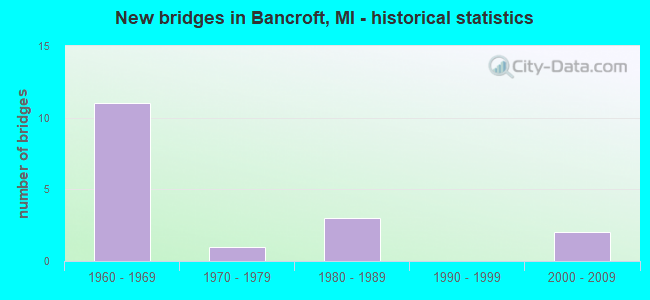
- New bridges - historical statistics
- 111960-1969
- 11970-1979
- 31980-1989
- 22000-2009

- Reconstructed bridges - Historical Statistics
- 21990-1999
- 12000-2009


- Bridge Condition - Deck
- 15.4%Very good
- 53.8%Good
- 23.1%Satisfactory
- 7.7%Fair

- Bridge Condition - Superstructure
- 23.1%Very good
- 30.8%Good
- 30.8%Satisfactory
- 15.4%Fair

- Bridge Condition - Substructure
- 23.1%Very good
- 46.2%Good
- 23.1%Satisfactory
- 7.7%Serious

- Bridge Condition - Channel
- 33.3%Good
- 55.6%Satisfactory
- 11.1%Fair
Find on map >> Show street view
Structure Number: 9734, Location: 3.6 MI SW OF M-71 (Lat: 42.905469, Lng: -84.062739), Route carried "on" structure: Interstate 69, Year Built: 1961, Year Reconstructed: 1998, Status: Open, Structure Length: 5.49m (18.01ft), Average Daily Traffic: 13,840 (year 2007), Truck Traffic: 22%, Average Future Daily Traffic: 19,072 (year 2018), Design Load: HS 20, Features Intersected: SHIAWASSEE RIVER
Minimum Vertical Clearance: 30.48m (100.00ft), Kilometerpoint: 27.913, Lanes on structure: 2, Base Highway Network: Yes (Inventory Route: 55, Subroute: 8), Owner: State Highway Agency, Approaching Roadway Width: 14.0m (45.9ft), Skew: 11 degrees, Material/Design: Steel, Design/Construction: Stringer/Multi-beam, Number Of Spans In Main Unit: 3, Length of Maximum Span: 17.7m (58.1ft), Curb-To-Curb Width: 14.0m (45.9ft), Out-to-Out Width: 15.0m (49.2ft)
Condition: Deck: Good, Superstructure: Satisfactory, Substructure: Satisfactory, Channel: Satisfactory, Operating Rating: 82.2 metric tons, Method Used To Determine Operating Rating: Load Factor (LF), Inventory Rating: 49.2 metric tons, Method Used To Determine Inventory Rating: Load Factor (LF), Structural Evaluation: Equal to present minimum criteria, Deck Geometry: Superior to present desirable criteria, Waterway Adequacy: Equal to present minimum criteria, Approach Roadway Alignment: Equal to present desirable criteria, Designated Inspection Frequency: Every 24 months, Inspection Date: August 2021, Deck Structure Type: Concrete Cast-file-Place, Wearing Surface/Protective System: Wearing Surface: Epoxy Overlay, Deck Protection: Epoxy Coated Reinforcing
Find on map >> Show street view
Structure Number: 9735, Location: 3.6 MI SW OF M-71 (Lat: 42.905714, Lng: -84.062858), Route carried "on" structure: Interstate 69, Year Built: 1961, Year Reconstructed: 1998, Status: Open, Structure Length: 5.49m (18.01ft), Average Daily Traffic: 13,840 (year 2007), Truck Traffic: 22%, Average Future Daily Traffic: 19,072 (year 2018), Design Load: HS 20, Features Intersected: SHIAWASSEE RIVER
Minimum Vertical Clearance: 30.48m (100.00ft), Kilometerpoint: 27.901, Lanes on structure: 2, Base Highway Network: Yes (Inventory Route: 55, Subroute: 9), Owner: State Highway Agency, Approaching Roadway Width: 14.0m (45.9ft), Skew: 11 degrees, Material/Design: Steel, Design/Construction: Stringer/Multi-beam, Number Of Spans In Main Unit: 3, Length of Maximum Span: 17.8m (58.4ft), Curb-To-Curb Width: 14.0m (45.9ft), Out-to-Out Width: 15.0m (49.2ft)
Condition: Deck: Good, Superstructure: Satisfactory, Substructure: Good, Channel: Satisfactory, Operating Rating: 82.2 metric tons, Method Used To Determine Operating Rating: Load Factor (LF), Inventory Rating: 49.2 metric tons, Method Used To Determine Inventory Rating: Load Factor (LF), Structural Evaluation: Equal to present minimum criteria, Deck Geometry: Superior to present desirable criteria, Waterway Adequacy: Equal to present minimum criteria, Approach Roadway Alignment: Equal to present desirable criteria, Designated Inspection Frequency: Every 24 months, Inspection Date: August 2021, Deck Structure Type: Concrete Cast-file-Place, Wearing Surface/Protective System: Wearing Surface: Epoxy Overlay, Deck Protection: Epoxy Coated Reinforcing
Find on map >> Show street view
Structure Number: 9747, Location: 5.8 MI NE OF M-52 (Lat: 42.878314, Lng: -84.122981), Route carried "on" structure: County highway 7657, Year Built: 1966, Year Reconstructed: 2011, Status: Open, Structure Length: 8.46m (27.76ft), Average Daily Traffic: 1,236 (year 2010), Truck Traffic: 4%, Average Future Daily Traffic: 1,373 (year 2030), Design Load: H 15, Features Intersected: I-69, Facility Carried by Structure: STATE RD
Minimum Vertical Clearance: 30.48m (100.00ft), Kilometerpoint: 2.375, Lanes on structure: 2, Lanes under structure: 4, Owner: State Highway Agency, Approaching Roadway Width: 9.8m (32.2ft), Skew: 4 degrees, Material/Design: Steel, Design/Construction: Stringer/Multi-beam, Number Of Spans In Main Unit: 4, Length of Maximum Span: 28.9m (94.8ft), Curb-To-Curb Width: 7.9m (25.9ft), Out-to-Out Width: 9.6m (31.5ft)
Condition: Deck: Satisfactory, Superstructure: Good, Substructure: Satisfactory, Operating Rating: 62.5 metric tons, Method Used To Determine Operating Rating: Load Factor (LF) rating reported by rating factor (RF) method using MS18 loading, Inventory Rating: 37.3 metric tons, Method Used To Determine Inventory Rating: Load Factor (LF) rating reported by rating factor (RF) method using MS18 loading, Structural Evaluation: Equal to present minimum criteria, Deck Geometry: Meets minimum limits, Underclear: High priority of corrective action, Approach Roadway Alignment: Equal to present desirable criteria, Designated Inspection Frequency: Every 24 months, Inspection Date: July 2021, Deck Structure Type: Concrete Cast-file-Place, Wearing Surface/Protective System: Wearing Surface: Latex Concrete
Find on map >> Show street view
Structure Number: 9748, Location: 7.8 MI NE OF M-52 (Lat: 42.894872, Lng: -84.092133), Route carried "on" structure: County highway 7636, Year Built: 1961, Status: Open, Structure Length: 10.91m (35.79ft), Average Daily Traffic: 2,396 (year 1993), Truck Traffic: 2%, Average Future Daily Traffic: 810 (year 1977), Design Load: HS 20, Features Intersected: I-69, Facility Carried by Structure: GRAND RIVER RD
Minimum Vertical Clearance: 30.48m (100.00ft), Kilometerpoint: 7.563, Lanes on structure: 2, Lanes under structure: 4, Owner: State Highway Agency, Approaching Roadway Width: 10.9m (35.8ft), Skew: 5 degrees, Material/Design: Steel, Design/Construction: Stringer/Multi-beam, Number Of Spans In Main Unit: 4, Length of Maximum Span: 37.5m (123.0ft), Curb-To-Curb Width: 8.8m (28.9ft), Out-to-Out Width: 10.0m (32.8ft)
Condition: Deck: Fair, Superstructure: Fair, Substructure: Satisfactory, Operating Rating: 56.1 metric tons, Method Used To Determine Operating Rating: Load Factor (LF) rating reported by rating factor (RF) method using MS18 loading, Inventory Rating: 33.4 metric tons, Method Used To Determine Inventory Rating: Load Factor (LF) rating reported by rating factor (RF) method using MS18 loading, Structural Evaluation: Somewhat better than minimum adequacy, Deck Geometry: Meets minimum limits, Underclear: High priority of corrective action, Approach Roadway Alignment: Equal to present minimum criteria, Designated Inspection Frequency: Every 24 months, Inspection Date: July 2021, Deck Structure Type: Concrete Cast-file-Place, Wearing Surface/Protective System: Wearing Surface: Latex Concrete
Find on map >> Show street view
Structure Number: 9749, Location: 3.9 MI SW OF M-71 (Lat: 42.903125, Lng: -84.069250), Route carried "on" structure: County highway 7669, Year Built: 1966, Status: Open, Structure Length: 7.07m (23.20ft), Average Daily Traffic: 370 (year 1993), Truck Traffic: 2%, Average Future Daily Traffic: 730 (year 1977), Design Load: H 15, Features Intersected: I-69, Facility Carried by Structure: BANCROFT RD
Minimum Vertical Clearance: 30.48m (100.00ft), Kilometerpoint: 2.169, Lanes on structure: 2, Lanes under structure: 4, Owner: State Highway Agency, Approaching Roadway Width: 7.9m (25.9ft), Skew: 2 degrees, Material/Design: Steel, Design/Construction: Stringer/Multi-beam, Number Of Spans In Main Unit: 4, Length of Maximum Span: 24.0m (78.7ft), Curb or Sidewalk Widths: Left: 0.4m (1.3ft), Right: 0.4m (1.3ft), Curb-To-Curb Width: 7.9m (25.9ft), Out-to-Out Width: 9.6m (31.5ft)
Condition: Deck: Satisfactory, Superstructure: Satisfactory, Substructure: Good, Operating Rating: 69.3 metric tons, Method Used To Determine Operating Rating: Load Factor (LF) rating reported by rating factor (RF) method using MS18 loading, Inventory Rating: 41.5 metric tons, Method Used To Determine Inventory Rating: Load Factor (LF) rating reported by rating factor (RF) method using MS18 loading, Structural Evaluation: Equal to present minimum criteria, Deck Geometry: Somewhat better than minimum adequacy, Underclear: High priority of corrective action, Approach Roadway Alignment: Equal to present desirable criteria, Designated Inspection Frequency: Every 24 months, Inspection Date: August 2021, Deck Structure Type: Concrete Cast-file-Place, Wearing Surface/Protective System: Wearing Surface: Epoxy Overlay
Find on map >> Show street view
Structure Number: 975, Location: 2.9 MI SW OF M-71 (Lat: 42.909492, Lng: -84.051533), Route carried "on" structure: County highway , Year Built: 1961, Status: Open, Structure Length: 8.17m (26.80ft), Average Daily Traffic: 674 (year 1997), Truck Traffic: 2%, Average Future Daily Traffic: 775 (year 2017), Design Load: H 15, Features Intersected: I-69, Facility Carried by Structure: NEWBURG RD
Minimum Vertical Clearance: 30.48m (100.00ft), Kilometerpoint: 5.906, Lanes on structure: 2, Lanes under structure: 4, Owner: State Highway Agency, Approaching Roadway Width: 7.9m (25.9ft), Skew: 4 degrees, Material/Design: Steel, Design/Construction: Stringer/Multi-beam, Number Of Spans In Main Unit: 4, Length of Maximum Span: 28.0m (91.9ft), Curb or Sidewalk Widths: Left: 0.7m (2.3ft), Right: 0.7m (2.3ft), Curb-To-Curb Width: 9.0m (29.5ft), Out-to-Out Width: 10.0m (32.8ft)
Condition: Deck: Satisfactory, Superstructure: Fair, Substructure: Good, Operating Rating: 52.5 metric tons, Method Used To Determine Operating Rating: Load Factor (LF) rating reported by rating factor (RF) method using MS18 loading, Inventory Rating: 31.4 metric tons, Method Used To Determine Inventory Rating: Load Factor (LF) rating reported by rating factor (RF) method using MS18 loading, Structural Evaluation: Somewhat better than minimum adequacy, Deck Geometry: Somewhat better than minimum adequacy, Underclear: Meets minimum limits, Approach Roadway Alignment: High priority of corrective action, Designated Inspection Frequency: Every 24 months, Inspection Date: August 2021, Deck Structure Type: Concrete Cast-file-Place, Wearing Surface/Protective System: Wearing Surface: Epoxy Overlay
Find on map >> Show street view
Structure Number: 9781, Location: 3 MILES EAST OF MORRICE (Lat: 42.835389, Lng: -84.108589), Route carried "on" structure: County highway 7616, Year Built: 2001, Status: Open, Structure Length: 1.34m (4.40ft), Average Daily Traffic: 844 (year 2003), Truck Traffic: 5%, Average Future Daily Traffic: 1,255 (year 2023), Design Load: HS 20, Features Intersected: LOOKINGGLASS RIVER, Facility Carried by Structure: BRITTON ROAD
Minimum Vertical Clearance: 30.48m (100.00ft), Kilometerpoint: 9.658, Lanes on structure: 2, Owner: County Highway Agency, Approaching Roadway Width: 10.0m (32.8ft), Skew: 6 degrees, Material/Design: Prestressed concrete, Design/Construction: Box Beam or Girders - Multiple, Number Of Spans In Main Unit: 1, Length of Maximum Span: 13.4m (44.0ft), Curb-To-Curb Width: 10.0m (32.8ft), Out-to-Out Width: 10.5m (34.4ft)
Condition: Deck: Very good, Superstructure: Very good, Substructure: Very good, Channel: Fair, Operating Rating: 71.6 metric tons, Method Used To Determine Operating Rating: Load Factor (LF) rating reported by rating factor (RF) method using MS18 loading, Inventory Rating: 43.1 metric tons, Method Used To Determine Inventory Rating: Load Factor (LF) rating reported by rating factor (RF) method using MS18 loading, Structural Evaluation: Equal to present desirable criteria, Deck Geometry: Equal to present minimum criteria, Waterway Adequacy: Superior to present desirable criteria, Approach Roadway Alignment: Equal to present desirable criteria, Designated Inspection Frequency: Every 24 months, Inspection Date: May 2020, Deck Structure Type: Concrete Cast-file-Place, Wearing Surface/Protective System: Wearing Surface: Integral Concrete, Deck Protection: Epoxy Coated Reinforcing
Find on map >> Show street view
Structure Number: 9783, Location: 1.5 MI NE OF BANCROFT (Lat: 42.896058, Lng: -84.054472), Route carried "on" structure: County highway 7628, Year Built: 1989, Status: Open, Structure Length: 4.26m (13.98ft), Average Daily Traffic: 2,699 (year 2011), Truck Traffic: 10%, Average Future Daily Traffic: 4,011 (year 2031), Design Load: HS 20, Features Intersected: SHIAWASSEE RIVER, Facility Carried by Structure: LANSING ROAD
Minimum Vertical Clearance: 30.48m (100.00ft), Kilometerpoint: 15.309, Lanes on structure: 2, Owner: County Highway Agency, Approaching Roadway Width: 11.9m (39.0ft), Material/Design: Prestressed concrete, Design/Construction: Stringer/Multi-beam, Number Of Spans In Main Unit: 2, Length of Maximum Span: 20.4m (66.9ft), Curb or Sidewalk Widths: Left: 0.8m (2.6ft), Right: 0.8m (2.6ft), Curb-To-Curb Width: 11.9m (39.0ft), Out-to-Out Width: 12.9m (42.3ft)
Condition: Deck: Good, Superstructure: Good, Substructure: Good, Channel: Satisfactory, Operating Rating: 70.0 metric tons, Method Used To Determine Operating Rating: Load Factor (LF) rating reported by rating factor (RF) method using MS18 loading, Inventory Rating: 42.1 metric tons, Method Used To Determine Inventory Rating: Load Factor (LF) rating reported by rating factor (RF) method using MS18 loading, Structural Evaluation: Better than present minimum criteria, Deck Geometry: Somewhat better than minimum adequacy, Waterway Adequacy: Equal to present desirable criteria, Approach Roadway Alignment: Equal to present desirable criteria, Designated Inspection Frequency: Every 24 months, Inspection Date: May 2020, Deck Structure Type: Concrete Precast Panels, Wearing Surface/Protective System: Wearing Surface: Monolithic Concrete, Deck Protection: Epoxy Coated Reinforcing
Find on map >> Show street view
Structure Number: 9787, Location: 2 MI SE OF BANCROFT (Lat: 42.861136, Lng: -84.031878), Route carried "on" structure: County highway , Year Built: 1988, Status: Open, Structure Length: 4.88m (16.01ft), Average Daily Traffic: 936 (year 2011), Truck Traffic: 10%, Average Future Daily Traffic: 1,391 (year 2031), Design Load: HS 20, Features Intersected: SHIAWASSEE RIVER, Facility Carried by Structure: COLE RD
Minimum Vertical Clearance: 30.48m (100.00ft), Kilometerpoint: 2.557, Lanes on structure: 2, Owner: County Highway Agency, Approaching Roadway Width: 11.9m (39.0ft), Skew: 3 degrees, Material/Design: Prestressed concrete, Design/Construction: Stringer/Multi-beam, Number Of Spans In Main Unit: 2, Length of Maximum Span: 23.4m (76.8ft), Curb-To-Curb Width: 12.2m (40.0ft), Out-to-Out Width: 12.9m (42.3ft)
Condition: Deck: Good, Superstructure: Very good, Substructure: Good, Channel: Good, Operating Rating: 69.0 metric tons, Method Used To Determine Operating Rating: Load Factor (LF) rating reported by rating factor (RF) method using MS18 loading, Inventory Rating: 41.5 metric tons, Method Used To Determine Inventory Rating: Load Factor (LF) rating reported by rating factor (RF) method using MS18 loading, Structural Evaluation: Better than present minimum criteria, Deck Geometry: Equal to present desirable criteria, Waterway Adequacy: Equal to present desirable criteria, Approach Roadway Alignment: Equal to present minimum criteria, Designated Inspection Frequency: Every 24 months, Inspection Date: May 2020, Deck Structure Type: Concrete Cast-file-Place, Wearing Surface/Protective System: Wearing Surface: Monolithic Concrete, Deck Protection: Epoxy Coated Reinforcing
Find on map >> Show street view
Structure Number: 9825, Location: 3.5 MI NE OF MORRICE (Lat: 42.857022, Lng: -84.117714), Route carried "on" structure: County highway , Year Built: 1963, Status: Posted for load, Structure Length: 1.18m (3.87ft), Average Daily Traffic: 223 (year 1998), Truck Traffic: 5%, Average Future Daily Traffic: 400 (year 2018), Design Load: HS 20, Features Intersected: LOOKINGGLASS RIVER, Facility Carried by Structure: WINEGAR RD
Minimum Vertical Clearance: 30.48m (100.00ft), Kilometerpoint: 0.586, Lanes on structure: 2, Owner: County Highway Agency, Approaching Roadway Width: 68.9m (226.0ft), Material/Design: Steel, Design/Construction: Stringer/Multi-beam, Number Of Spans In Main Unit: 1, Length of Maximum Span: 10.3m (33.8ft), Curb-To-Curb Width: 7.9m (25.9ft), Out-to-Out Width: 8.0m (26.2ft)
Condition: Deck: Good, Superstructure: Satisfactory, Substructure: Good, Channel: Satisfactory, Operating Rating: 44.1 metric tons, Method Used To Determine Operating Rating: Load Factor (LF) rating reported by rating factor (RF) method using MS18 loading, Inventory Rating: 26.2 metric tons, Method Used To Determine Inventory Rating: Load Factor (LF) rating reported by rating factor (RF) method using MS18 loading, Structural Evaluation: Equal to present minimum criteria, Deck Geometry: Somewhat better than minimum adequacy, Waterway Adequacy: Better than present minimum criteria, Approach Roadway Alignment: Better than present minimum criteria, Bridge Posting: Required (Relationship of Operating Rating to Maximum Legal Load: 10.0 - 19.9% below), Designated Inspection Frequency: Every 24 months, Inspection Date: May 2020, Deck Structure Type: Concrete Cast-file-Place, Wearing Surface/Protective System: Wearing Surface: Monolithic Concrete
Find on map >> Show street view
Structure Number: 9832, Location: 3.5 MI NW OF BYRON (Lat: 42.840117, Lng: -84.009667), Route carried "on" structure: County highway , Year Built: 1975, Status: Posted for load, Structure Length: 3.65m (11.98ft), Average Daily Traffic: 360 (year 1998), Truck Traffic: 5%, Average Future Daily Traffic: 650 (year 2018), Design Load: HS 20, Features Intersected: SHIAWASSEE RIVER, Facility Carried by Structure: LEHRING RD
Minimum Vertical Clearance: 30.48m (100.00ft), Kilometerpoint: 2.002, Lanes on structure: 2, Owner: County Highway Agency, Approaching Roadway Width: 9.1m (29.9ft), Material/Design: Prestressed concrete, Design/Construction: Box Beam or Girders - Multiple, Number Of Spans In Main Unit: 2, Length of Maximum Span: 17.3m (56.8ft), Curb-To-Curb Width: 7.9m (25.9ft), Out-to-Out Width: 8.2m (26.9ft)
Condition: Deck: Good, Superstructure: Good, Substructure: Serious, Channel: Good, Operating Rating: 42.1 metric tons, Method Used To Determine Operating Rating: Load Factor (LF) rating reported by rating factor (RF) method using MS18 loading, Inventory Rating: 25.3 metric tons, Method Used To Determine Inventory Rating: Load Factor (LF) rating reported by rating factor (RF) method using MS18 loading, Structural Evaluation: High priority of corrective action, Deck Geometry: Somewhat better than minimum adequacy, Waterway Adequacy: Better than present minimum criteria, Approach Roadway Alignment: Equal to present minimum criteria, Bridge Posting: Required (Relationship of Operating Rating to Maximum Legal Load: 20.0 - 29.9% below), Designated Inspection Frequency: Every 12 months, Inspection Date: May 2021, Deck Structure Type: Concrete Precast Panels, Wearing Surface/Protective System: Wearing Surface: Bituminous
Find on map >> Show street view
Structure Number: 9864, Location: 1 MI NE OF BANCROFT (Lat: 42.883486, Lng: -84.046261), Route carried "on" structure: County highway , Year Built: 1983, Status: Posted for load, Structure Length: 3.84m (12.60ft), Average Daily Traffic: 320 (year 1998), Truck Traffic: 5%, Average Future Daily Traffic: 575 (year 2018), Design Load: HS 20, Features Intersected: SHIAWASSEE RIVER, Facility Carried by Structure: EXCHANGE RD
Minimum Vertical Clearance: 30.48m (100.00ft), Kilometerpoint: 0.087, Lanes on structure: 2, Owner: County Highway Agency, Approaching Roadway Width: 9.1m (29.9ft), Skew: 1 degrees, Material/Design: Prestressed concrete, Design/Construction: Box Beam or Girders - Multiple, Number Of Spans In Main Unit: 3, Length of Maximum Span: 19.2m (63.0ft), Curb-To-Curb Width: 9.1m (29.9ft), Out-to-Out Width: 9.4m (30.8ft)
Condition: Deck: Good, Superstructure: Good, Substructure: Very good, Channel: Good, Operating Rating: 48.3 metric tons, Method Used To Determine Operating Rating: Load Factor (LF) rating reported by rating factor (RF) method using MS18 loading, Inventory Rating: 28.8 metric tons, Method Used To Determine Inventory Rating: Load Factor (LF) rating reported by rating factor (RF) method using MS18 loading, Structural Evaluation: Better than present minimum criteria, Deck Geometry: Equal to present minimum criteria, Waterway Adequacy: Equal to present desirable criteria, Approach Roadway Alignment: Meets minimum limits, Bridge Posting: Required (Relationship of Operating Rating to Maximum Legal Load: 10.0 - 19.9% below), Designated Inspection Frequency: Every 24 months, Inspection Date: May 2020, Deck Structure Type: Concrete Precast Panels, Wearing Surface/Protective System: Wearing Surface: Bituminous, Membrane: Preformed Fabric, Deck Protection: Epoxy Coated Reinforcing
Find on map >> Show street view
Structure Number: 13166, Location: 0.1 MI EAST OF BLIVEN RD (Lat: 42.807850, Lng: -84.053831), Route carried "on" structure: County highway , Year Built: 2007, Status: Open, Structure Length: 1.34m (4.40ft), Average Daily Traffic: 927 (year 2011), Truck Traffic: 3%, Average Future Daily Traffic: 1,378 (year 2031), Design Load: HS 20, Features Intersected: NEAL DRAIN, Facility Carried by Structure: BEARD RD
Minimum Vertical Clearance: 30.48m (100.00ft), Kilometerpoint: 22.467, Lanes on structure: 2, Owner: County Highway Agency, Approaching Roadway Width: 8.8m (28.9ft), Material/Design: Prestressed concrete, Design/Construction: Box Beam or Girders - Multiple, Number Of Spans In Main Unit: 1, Length of Maximum Span: 12.2m (40.0ft), Curb-To-Curb Width: 8.8m (28.9ft), Out-to-Out Width: 9.5m (31.2ft)
Condition: Deck: Very good, Superstructure: Very good, Substructure: Very good, Channel: Satisfactory, Operating Rating: 82.0 metric tons, Method Used To Determine Operating Rating: Load Factor (LF) rating reported by rating factor (RF) method using MS18 loading, Inventory Rating: 49.2 metric tons, Method Used To Determine Inventory Rating: Load Factor (LF) rating reported by rating factor (RF) method using MS18 loading, Structural Evaluation: Equal to present desirable criteria, Deck Geometry: Somewhat better than minimum adequacy, Waterway Adequacy: Better than present minimum criteria, Approach Roadway Alignment: Equal to present desirable criteria, Designated Inspection Frequency: Every 24 months, Inspection Date: May 2020, Deck Structure Type: Concrete Cast-file-Place, Wearing Surface/Protective System: Wearing Surface: Integral Concrete, Deck Protection: Epoxy Coated Reinforcing
Find on map >> Show street view
Structure Number: 9747, Location: 5.8 MI NE OF M-52 (Lat: 42.878314, Lng: -84.122981), Route carried "under" structure: Interstate 69, Year Built: 1966, Structure Length: 0. m, Average Daily Traffic: 36,360 (year 2010), Truck Traffic: 19%, Features Intersected: I-69, Facility Carried by Structure: STATE RD
Minimum Vertical Clearance: 4.57m (14.99ft), Kilometerpoint: 22.097, Lanes on structure: 2, Lanes under structure: 4, Material/Design: Steel, Design/Construction: Stringer/Multi-beam, Length of Maximum Span: 28.9m (94.8ft)
Find on map >> Show street view
Structure Number: 9748, Location: 7.8 MI NE OF M-52 (Lat: 42.894872, Lng: -84.092133), Route carried "under" structure: Interstate 69, Year Built: 1961, Structure Length: 0. m, Average Daily Traffic: 28,352 (year 2007), Truck Traffic: 22%, Features Intersected: I-69, Facility Carried by Structure: GRAND RIVER RD
Minimum Vertical Clearance: 4.50m (14.76ft), Kilometerpoint: 25.240, Lanes on structure: 2, Lanes under structure: 4, Material/Design: Steel, Design/Construction: Stringer/Multi-beam, Length of Maximum Span: 37.5m (123.0ft)
Find on map >> Show street view
Structure Number: 9749, Location: 3.9 MI SW OF M-71 (Lat: 42.903125, Lng: -84.069250), Route carried "under" structure: Interstate 69, Year Built: 1966, Structure Length: 0. m, Average Daily Traffic: 27,680 (year 2007), Truck Traffic: 22%, Features Intersected: I-69, Facility Carried by Structure: BANCROFT RD
Minimum Vertical Clearance: 4.67m (15.32ft), Kilometerpoint: 27.321, Lanes on structure: 2, Lanes under structure: 4, Material/Design: Steel, Design/Construction: Stringer/Multi-beam, Length of Maximum Span: 24.0m (78.7ft)
Find on map >> Show street view
Structure Number: 975, Location: 2.9 MI SW OF M-71 (Lat: 42.909492, Lng: -84.051533), Route carried "under" structure: Interstate 69, Year Built: 1961, Structure Length: 0. m, Average Daily Traffic: 27,680 (year 2007), Truck Traffic: 22%, Features Intersected: I-69, Facility Carried by Structure: NEWBURG RD
Minimum Vertical Clearance: 4.95m (16.24ft), Kilometerpoint: 28.932, Lanes on structure: 2, Lanes under structure: 4, Material/Design: Steel, Design/Construction: Stringer/Multi-beam, Length of Maximum Span: 28.0m (91.9ft)