Bridge Statistics for Avondale, Colorado (CO)
Condition, Traffic, Stress, Structural Evaluation, Project Costs
- National Bridge Inventory (NBI) Statistics
- 15Number of bridges
- 240ft / 72.8mTotal length
- $4,840,000Total costs
- 39,459Total average daily traffic
- 3,422Total average daily truck traffic
- National Bridge Inventory (NBI) Registered Bridges for Avondale
- No street view available for this location
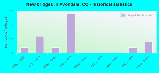
- New bridges - historical statistics
- 11920-1929
- 31930-1939
- 11940-1949
- 71950-1959
- 11990-1999
- 22000-2009

- Reconstructed bridges - Historical Statistics
- 11930-1939
- 01940-1949
- 01950-1959
- 01960-1969
- 01970-1979
- 11980-1989


- Bridge Condition - Deck
- 9.1%Good
- 27.3%Satisfactory
- 27.3%Fair
- 36.4%Poor

- Bridge Condition - Superstructure
- 27.3%Good
- 18.2%Satisfactory
- 54.5%Fair

- Bridge Condition - Substructure
- 36.4%Good
- 36.4%Satisfactory
- 27.3%Fair

- Bridge Condition - Channel
- 33.3%Very good
- 33.3%Good
- 33.3%Satisfactory

- Bridge Condition - Culverts
- 33.3%Satisfactory
- 66.7%Fair
Find on map >> Show street view
Structure Number: K-19-Q, Location: 4.7 MI E OF JCT SH 231 S (Lat: 38.265811, Lng: -104.373011), Route carried "on" structure: US 50B, Year Built: 1953, Status: Open, Structure Length: 9.31m (30.54ft), Average Daily Traffic: 4,300 (year 2020), Truck Traffic: 12%, Average Future Daily Traffic: 4,902 (year 2040), Design Load: HS 20, Features Intersected: CHICO CREEK, Facility Carried by Structure: US 50 ML WBND
Minimum Vertical Clearance: 30.45m (99.90ft), Kilometerpoint: 21.533, Lanes on structure: 2, Base Highway Network: Yes, Owner: State Highway Agency, Approaching Roadway Width: 11.6m (38.1ft), Skew: 13 degrees, Material/Design: Steel continuous, Design/Construction: Stringer/Multi-beam, Number Of Spans In Main Unit: 5, Length of Maximum Span: 20.4m (66.9ft), Curb-To-Curb Width: 9.1m (29.9ft), Out-to-Out Width: 10.4m (34.1ft)
Condition: Deck: Fair, Superstructure: Satisfactory, Substructure: Good, Channel: Very good, Operating Rating: 79.6 metric tons, Method Used To Determine Operating Rating: Load Factor (LF), Inventory Rating: 47.6 metric tons, Method Used To Determine Inventory Rating: Load Factor (LF), Structural Evaluation: Equal to present minimum criteria, Deck Geometry: Meets minimum limits, Waterway Adequacy: Equal to present desirable criteria, Approach Roadway Alignment: Equal to present desirable criteria, Designated Inspection Frequency: Every 24 months, Inspection Date: June 2020, Deck Structure Type: Concrete Cast-file-Place, Wearing Surface/Protective System: Wearing Surface: Bituminous, Membrane: Built-up
Find on map >> Show street view
Structure Number: K-19-R, Location: 1.9 MI E OF JCT SH 229 S (Lat: 38.258892, Lng: -104.334272), Route carried "on" structure: State highway 96B, Year Built: 1939, Status: Open, Structure Length: 0.98m (3.22ft), Average Daily Traffic: 1,600 (year 2020), Truck Traffic: 8%, Average Future Daily Traffic: 1,856 (year 2040), Design Load: H 15, Features Intersected: ARROYO, Facility Carried by Structure: SH 96 ML
Minimum Vertical Clearance: 30.45m (99.90ft), Kilometerpoint: 3.069, Lanes on structure: 2, Base Highway Network: Yes, Owner: State Highway Agency, Approaching Roadway Width: 9.1m (29.9ft), Material/Design: Concrete, Design/Construction: Culvert, Number Of Spans In Main Unit: 3, Length of Maximum Span: 3.0m (9.8ft), Out-to-Out Width: 11.6m (38.1ft)
Condition: Channel: Very good, Culverts: Fair, Operating Rating: 36.3 metric tons, Method Used To Determine Operating Rating: Field evaluation and documented engineering judgment, Inventory Rating: 32.7 metric tons, Method Used To Determine Inventory Rating: Field evaluation and documented engineering judgment, Structural Evaluation: Somewhat better than minimum adequacy, Waterway Adequacy: Equal to present desirable criteria, Approach Roadway Alignment: Equal to present desirable criteria, Designated Inspection Frequency: Every 24 months, Inspection Date: January 2021
Find on map >> Show street view
Structure Number: K-19-S, Location: 2.7 MI E OF JCT SH 229 S (Lat: 38.256711, Lng: -104.319356), Route carried "on" structure: State highway 96B, Year Built: 1939, Status: Open, Structure Length: 0.64m (2.10ft), Average Daily Traffic: 1,600 (year 2020), Truck Traffic: 8%, Average Future Daily Traffic: 1,856 (year 2040), Design Load: H 20, Features Intersected: ARROYO, Facility Carried by Structure: SH 96 ML
Minimum Vertical Clearance: 30.45m (99.90ft), Kilometerpoint: 4.394, Lanes on structure: 2, Base Highway Network: Yes, Owner: State Highway Agency, Approaching Roadway Width: 9.1m (29.9ft), Material/Design: Concrete, Design/Construction: Culvert, Number Of Spans In Main Unit: 2, Length of Maximum Span: 3.0m (9.8ft), Out-to-Out Width: 11.6m (38.1ft)
Condition: Channel: Very good, Culverts: Fair, Operating Rating: 36.3 metric tons, Method Used To Determine Operating Rating: Field evaluation and documented engineering judgment, Inventory Rating: 32.7 metric tons, Method Used To Determine Inventory Rating: Field evaluation and documented engineering judgment, Structural Evaluation: Somewhat better than minimum adequacy, Waterway Adequacy: Equal to present desirable criteria, Approach Roadway Alignment: Equal to present desirable criteria, Designated Inspection Frequency: Every 24 months, Inspection Date: January 2021
Find on map >> Show street view
Structure Number: K-19-U, Location: 0.4 MI W OF JCT SH 96 E (Lat: 38.265644, Lng: -104.373069), Route carried "on" structure: US 50B, Year Built: 1953, Status: Open, Structure Length: 9.31m (30.54ft), Average Daily Traffic: 4,300 (year 2020), Truck Traffic: 12%, Average Future Daily Traffic: 4,902 (year 2040), Design Load: HS 20, Features Intersected: CHICO CREEK, Facility Carried by Structure: US 50 ML EBND
Minimum Vertical Clearance: 30.45m (99.90ft), Kilometerpoint: 21.543, Lanes on structure: 2, Base Highway Network: Yes, Owner: State Highway Agency, Approaching Roadway Width: 11.6m (38.1ft), Skew: 13 degrees, Material/Design: Steel continuous, Design/Construction: Stringer/Multi-beam, Number Of Spans In Main Unit: 5, Length of Maximum Span: 20.4m (66.9ft), Curb-To-Curb Width: 9.1m (29.9ft), Out-to-Out Width: 10.4m (34.1ft)
Condition: Deck: Fair, Superstructure: Fair, Substructure: Satisfactory, Channel: Very good, Operating Rating: 79.6 metric tons, Method Used To Determine Operating Rating: Load Factor (LF), Inventory Rating: 47.6 metric tons, Method Used To Determine Inventory Rating: Load Factor (LF), Structural Evaluation: Somewhat better than minimum adequacy, Deck Geometry: Meets minimum limits, Waterway Adequacy: Equal to present desirable criteria, Approach Roadway Alignment: Equal to present desirable criteria, Designated Inspection Frequency: Every 24 months, Inspection Date: June 2020, Deck Structure Type: Concrete Cast-file-Place, Wearing Surface/Protective System: Wearing Surface: Bituminous, Membrane: Built-up
Find on map >> Show street view
Structure Number: K-19-V, Location: 5.0 MI E OF JCT SH 231 S (Lat: 38.262919, Lng: -104.369753), Route carried "on" structure: City street , Year Built: 1953, Status: Open, Structure Length: 6.97m (22.87ft), Average Daily Traffic: 8,400 (year 2018), Truck Traffic: 2%, Average Future Daily Traffic: 560 (year 2034), Design Load: HS 20, Features Intersected: US 50 ML, Facility Carried by Structure: ORDINANCE ROAD
Minimum Vertical Clearance: 30.45m (99.90ft), Kilometerpoint: 0.000, Lanes on structure: 2, Lanes under structure: 5, Owner: State Highway Agency, Approaching Roadway Width: 8.5m (27.9ft), Skew: 2 degrees, Material/Design: Steel continuous, Design/Construction: Stringer/Multi-beam, Number Of Spans In Main Unit: 4, Length of Maximum Span: 19.8m (65.0ft), Curb or Sidewalk Widths: Left: 0.6m (2.0ft), Right: 0.6m (2.0ft), Curb-To-Curb Width: 9.1m (29.9ft), Out-to-Out Width: 10.4m (34.1ft)
Condition: Deck: Poor, Superstructure: Fair, Substructure: Satisfactory, Operating Rating: 64.0 metric tons, Method Used To Determine Operating Rating: Load Factor (LF), Inventory Rating: 38.4 metric tons, Method Used To Determine Inventory Rating: Load Factor (LF), Structural Evaluation: Somewhat better than minimum adequacy, Deck Geometry: Meets minimum limits, Underclear: Meets minimum limits, Approach Roadway Alignment: Equal to present desirable criteria, Designated Inspection Frequency: Every 24 months, Inspection Date: June 2020, Deck Structure Type: Concrete Cast-file-Place, Wearing Surface/Protective System: Wearing Surface: Bituminous
Find on map >> Show street view
Structure Number: K-19-W, Location: ROAD TO PUEBLO ARMY DEPOT (Lat: 38.265989, Lng: -104.368717), Route carried "on" structure: ServiceUS 50B, Year Built: 1953, Status: Open, Structure Length: 7.71m (25.30ft), Average Daily Traffic: 8,600 (year 2020), Truck Traffic: 12%, Average Future Daily Traffic: 9,804 (year 2040), Design Load: HS 20, Features Intersected: BNSF RR AR, Facility Carried by Structure: US 50 SERVICE RD
Minimum Vertical Clearance: 30.45m (99.90ft), Kilometerpoint: 0.349, Lanes on structure: 2, Base Highway Network: Yes, Owner: State Highway Agency, Approaching Roadway Width: 8.5m (27.9ft), Material/Design: Steel continuous, Design/Construction: Stringer/Multi-beam, Number Of Spans In Main Unit: 4, Length of Maximum Span: 20.6m (67.6ft), Curb or Sidewalk Widths: Left: 0.6m (2.0ft), Right: 0.6m (2.0ft), Curb-To-Curb Width: 9.1m (29.9ft), Out-to-Out Width: 10.4m (34.1ft)
Condition: Deck: Poor, Superstructure: Fair, Substructure: Fair, Operating Rating: 28.5 metric tons, Method Used To Determine Operating Rating: Load Factor (LF), Inventory Rating: 17.1 metric tons, Method Used To Determine Inventory Rating: Load Factor (LF), Structural Evaluation: Meets minimum limits, Deck Geometry: Meets minimum limits, Underclear: Equal to present minimum criteria, Approach Roadway Alignment: Equal to present desirable criteria, Designated Inspection Frequency: Every 24 months, Inspection Date: June 2020, Deck Structure Type: Concrete Cast-file-Place, Wearing Surface/Protective System: Wearing Surface: Bituminous
Find on map >> Show street view
Structure Number: K-19-X, Location: 0.5 MI E OF JCT US 50 E (Lat: 38.263828, Lng: -104.358742), Route carried "on" structure: State highway 96B, Year Built: 1939, Status: Open, Structure Length: 0.64m (2.10ft), Average Daily Traffic: 1,700 (year 2020), Truck Traffic: 7%, Average Future Daily Traffic: 1,938 (year 2040), Design Load: H 20, Features Intersected: DRAW, Facility Carried by Structure: SH 96 ML
Minimum Vertical Clearance: 30.45m (99.90ft), Kilometerpoint: 0.855, Lanes on structure: 2, Base Highway Network: Yes, Owner: State Highway Agency, Approaching Roadway Width: 9.1m (29.9ft), Material/Design: Concrete, Design/Construction: Culvert, Number Of Spans In Main Unit: 2, Length of Maximum Span: 3.0m (9.8ft), Out-to-Out Width: 11.6m (38.1ft)
Condition: Channel: Good, Culverts: Satisfactory, Operating Rating: 36.3 metric tons, Method Used To Determine Operating Rating: Field evaluation and documented engineering judgment, Inventory Rating: 32.7 metric tons, Method Used To Determine Inventory Rating: Field evaluation and documented engineering judgment, Structural Evaluation: Equal to present minimum criteria, Waterway Adequacy: Equal to present desirable criteria, Approach Roadway Alignment: Equal to present desirable criteria, Designated Inspection Frequency: Every 24 months, Inspection Date: January 2021
Find on map >> Show street view
Structure Number: L-19-A, Location: 3.5 Mi E/ SH 231 VINELAND (Lat: 38.244467, Lng: -104.395847), Route carried "on" structure: US 50C, Year Built: 1942, Status: Open, Structure Length: 1.95m (6.40ft), Average Daily Traffic: 2,000 (year 2020), Truck Traffic: 6%, Average Future Daily Traffic: 2,080 (year 2040), Design Load: H 20, Features Intersected: SIX MILE CREEK, Facility Carried by Structure: US 50 BUSINESS
Minimum Vertical Clearance: 30.45m (99.90ft), Kilometerpoint: 20.666, Lanes on structure: 2, Base Highway Network: Yes, Owner: State Highway Agency, Approaching Roadway Width: 8.5m (27.9ft), Material/Design: Steel, Design/Construction: Stringer/Multi-beam, Number Of Spans In Main Unit: 1, Length of Maximum Span: 18.3m (60.0ft), Curb-To-Curb Width: 9.1m (29.9ft), Out-to-Out Width: 10.2m (33.5ft)
Condition: Deck: Poor, Superstructure: Fair, Substructure: Fair, Channel: Good, Operating Rating: 43.3 metric tons, Method Used To Determine Operating Rating: Load Factor (LF), Inventory Rating: 25.9 metric tons, Method Used To Determine Inventory Rating: Load Factor (LF), Structural Evaluation: Somewhat better than minimum adequacy, Deck Geometry: Somewhat better than minimum adequacy, Waterway Adequacy: Equal to present desirable criteria, Approach Roadway Alignment: Better than present minimum criteria, Designated Inspection Frequency: Every 24 months, Inspection Date: June 2020, Deck Structure Type: Concrete Cast-file-Place, Wearing Surface/Protective System: Wearing Surface: Bituminous
Find on map >> Show street view
Structure Number: L-19-F, Location: JUST E. OF AVONDALE (Lat: 38.236483, Lng: -104.339725), Route carried "on" structure: US 50C, Year Built: 1927, Year Reconstructed: 1937, Status: Open, Structure Length: 3.11m (10.20ft), Average Daily Traffic: 840 (year 2020), Truck Traffic: 6%, Average Future Daily Traffic: 882 (year 2040), Design Load: H 15, Features Intersected: DRAW, Facility Carried by Structure: US 50 BUS. RT
Minimum Vertical Clearance: 30.45m (99.90ft), Kilometerpoint: 25.951, Lanes on structure: 2, Base Highway Network: Yes, Owner: State Highway Agency, Approaching Roadway Width: 9.1m (29.9ft), Material/Design: Concrete, Design/Construction: Slab, Number Of Spans In Main Unit: 5, Length of Maximum Span: 5.5m (18.0ft), Curb or Sidewalk Widths: Left: 0.2m (0.7ft), Right: 0.2m (0.7ft), Curb-To-Curb Width: 9.1m (29.9ft), Out-to-Out Width: 10.2m (33.5ft)
Condition: Deck: Fair, Superstructure: Fair, Substructure: Fair, Channel: Good, Operating Rating: 41.7 metric tons, Method Used To Determine Operating Rating: Load Factor (LF), Inventory Rating: 25.4 metric tons, Method Used To Determine Inventory Rating: Load Factor (LF), Structural Evaluation: Somewhat better than minimum adequacy, Deck Geometry: Equal to present minimum criteria, Waterway Adequacy: Equal to present desirable criteria, Approach Roadway Alignment: Equal to present desirable criteria, Length Of Structure Improvement: 3.96m (12.99ft), Designated Inspection Frequency: Every 12 months, Inspection Date: May 2021, Bridge Improvement Cost: $2,601,000, Roadway Improvement Cost: $260,000, Total Project Cost: $2,861,000 ( Estimate for 2019), Deck Structure Type: Concrete Cast-file-Place, Wearing Surface/Protective System: Wearing Surface: Bituminous
Find on map >> Show street view
Structure Number: L-19-H, Location: 1.7 MI E OF N. AVONDALE (Lat: 38.245275, Lng: -104.344764), Route carried "on" structure: US 50B, Year Built: 1955, Year Reconstructed: 1986, Status: Open, Structure Length: 12.38m (40.62ft), Average Daily Traffic: 4,100 (year 2020), Truck Traffic: 13%, Average Future Daily Traffic: 4,387 (year 2040), Design Load: HS 20, Features Intersected: ARKANSAS RIVER, Facility Carried by Structure: US 50 ML
Minimum Vertical Clearance: 30.45m (99.90ft), Kilometerpoint: 24.903, Lanes on structure: 2, Base Highway Network: Yes, Owner: State Highway Agency, Approaching Roadway Width: 13.4m (44.0ft), Skew: 3 degrees, Material/Design: Steel continuous, Design/Construction: Stringer/Multi-beam, Number Of Spans In Main Unit: 6, Length of Maximum Span: 23.2m (76.1ft), Curb-To-Curb Width: 9.8m (32.2ft), Out-to-Out Width: 10.5m (34.4ft)
Condition: Deck: Satisfactory, Superstructure: Satisfactory, Substructure: Satisfactory, Channel: Satisfactory, Operating Rating: 77.9 metric tons, Method Used To Determine Operating Rating: Load Factor (LF), Inventory Rating: 46.6 metric tons, Method Used To Determine Inventory Rating: Load Factor (LF), Structural Evaluation: Equal to present minimum criteria, Deck Geometry: Meets minimum limits, Waterway Adequacy: Better than present minimum criteria, Approach Roadway Alignment: Equal to present desirable criteria, Designated Inspection Frequency: Every 24 months, Inspection Date: May 2020, Deck Structure Type: Concrete Cast-file-Place, Wearing Surface/Protective System: Wearing Surface: Bituminous, Membrane: Preformed Fabric, Deck Protection: Epoxy Coated Reinforcing
Find on map >> Show street view
Structure Number: PUCO 0.04-409A, Location: 1.2 MI S OF SANTE FE DR (Lat: 38.226794, Lng: -104.404575), Route carried "on" structure: County highway , Year Built: 1950, Status: Open, Structure Length: 2.00m (6.56ft), Average Daily Traffic: 105 (year 2018), Truck Traffic: 2%, Average Future Daily Traffic: 148 (year 2038), Features Intersected: SIX MILE CREEK, Facility Carried by Structure: Co RD 42/42nd LN
Minimum Vertical Clearance: 30+ m (98+ ft), Kilometerpoint: 1.610, Lanes on structure: 2, Owner: County Highway Agency, Approaching Roadway Width: 6.4m (21.0ft), Material/Design: Steel, Design/Construction: Truss - Thru, Number Of Spans In Main Unit: 1, Length of Maximum Span: 18.2m (59.7ft), Curb-To-Curb Width: 7.1m (23.3ft), Out-to-Out Width: 7.4m (24.3ft)
Condition: Deck: Poor, Superstructure: Fair, Substructure: Satisfactory, Channel: Satisfactory, Operating Rating: 34.8 metric tons, Method Used To Determine Operating Rating: Load Factor (LF), Inventory Rating: 25.4 metric tons, Method Used To Determine Inventory Rating: Load Factor (LF), Structural Evaluation: Somewhat better than minimum adequacy, Deck Geometry: Meets minimum limits, Waterway Adequacy: Equal to present desirable criteria, Approach Roadway Alignment: Better than present minimum criteria, Length Of Structure Improvement: 2.80m (9.19ft), Designated Inspection Frequency: Every 24 months, Critical Feature Inspection Frequency: Every 24 months, Inspection Date: November 2020, Critical Feature Inspection Date: November 2020, Bridge Improvement Cost: $1,583,000, Roadway Improvement Cost: $158,000, Total Project Cost: $1,979,000 ( Estimate for 2018), Deck Structure Type: Wood or Timber, Wearing Surface/Protective System: Wearing Surface: Bituminous
Find on map >> Show street view
Structure Number: PUCO 0.06-303ER, Location: 0.5 MI S OF OLSON RD (Lat: 38.206083, Lng: -104.349200), Route carried "on" structure: County highway , Year Built: 1996, Status: Open, Structure Length: 0.96m (3.15ft), Average Daily Traffic: 199 (year 2018), Truck Traffic: 2%, Average Future Daily Traffic: 280 (year 2038), Design Load: HS 20, Features Intersected: BESSEMER DITCH, Facility Carried by Structure: CO RD 327/AVONDALE
Minimum Vertical Clearance: 30+ m (98+ ft), Kilometerpoint: 6.794, Lanes on structure: 2, Owner: County Highway Agency, Approaching Roadway Width: 9.1m (29.9ft), Material/Design: Steel, Design/Construction: Stringer/Multi-beam, Number Of Spans In Main Unit: 1, Length of Maximum Span: 8.9m (29.2ft), Curb-To-Curb Width: 9.2m (30.2ft), Out-to-Out Width: 10.0m (32.8ft)
Condition: Deck: Good, Superstructure: Good, Substructure: Good, Channel: Good, Operating Rating: 71.1 metric tons, Method Used To Determine Operating Rating: Load Factor (LF), Inventory Rating: 42.6 metric tons, Method Used To Determine Inventory Rating: Load Factor (LF), Structural Evaluation: Better than present minimum criteria, Deck Geometry: Equal to present minimum criteria, Waterway Adequacy: Better than present minimum criteria, Approach Roadway Alignment: Better than present minimum criteria, Designated Inspection Frequency: Every 24 months, Inspection Date: November 2020, Deck Structure Type: Concrete Cast-file-Place, Wearing Surface/Protective System: Wearing Surface: Monolithic Concrete, Deck Protection: Epoxy Coated Reinforcing
Find on map >> Show street view
Structure Number: PUCO 0.24-404AR, Location: 0.24 MI S OF SH 50 (Lat: 38.248167, Lng: -104.398956), Route carried "on" structure: County highway , Year Built: 2006, Status: Open, Structure Length: 7.92m (25.98ft), Average Daily Traffic: 132 (year 2018), Truck Traffic: 2%, Average Future Daily Traffic: 186 (year 2038), Design Load: HL 93, Features Intersected: ARKANSAS RIVER, Facility Carried by Structure: CR 442 (NYBERG RD)
Minimum Vertical Clearance: 30+ m (98+ ft), Kilometerpoint: 0.375, Lanes on structure: 2, Owner: County Highway Agency, Approaching Roadway Width: 9.1m (29.9ft), Material/Design: Prestressed concrete continuous, Design/Construction: Stringer/Multi-beam, Number Of Spans In Main Unit: 2, Length of Maximum Span: 38.5m (126.3ft), Curb-To-Curb Width: 9.2m (30.2ft), Out-to-Out Width: 10.1m (33.1ft)
Condition: Deck: Satisfactory, Superstructure: Good, Substructure: Good, Channel: Satisfactory, Operating Rating: 45.3 metric tons, Method Used To Determine Operating Rating: Load Factor (LF), Inventory Rating: 27.1 metric tons, Method Used To Determine Inventory Rating: Load Factor (LF), Structural Evaluation: Equal to present minimum criteria, Deck Geometry: Equal to present minimum criteria, Waterway Adequacy: Equal to present desirable criteria, Approach Roadway Alignment: Equal to present minimum criteria, Designated Inspection Frequency: Every 24 months, Inspection Date: November 2020, Deck Structure Type: Concrete Cast-file-Place, Wearing Surface/Protective System: Wearing Surface: Monolithic Concrete, Deck Protection: Epoxy Coated Reinforcing
Find on map >> Show street view
Structure Number: PUCO 0.42-409BR, Location: 0.3 MI S OF SH 50 (Lat: 38.242044, Lng: -104.349103), Route carried "on" structure: County highway , Year Built: 2005, Status: Open, Structure Length: 8.88m (29.13ft), Average Daily Traffic: 1,203 (year 2018), Truck Traffic: 5%, Average Future Daily Traffic: 1,696 (year 2038), Design Load: HS 25 or greater, Features Intersected: ARKANSAS RIVER, Facility Carried by Structure: CR 327 (AVONDALE)
Minimum Vertical Clearance: 30+ m (98+ ft), Kilometerpoint: 11.000, Lanes on structure: 2, Owner: County Highway Agency, Approaching Roadway Width: 11.6m (38.1ft), Material/Design: Prestressed concrete continuous, Design/Construction: Stringer/Multi-beam, Number Of Spans In Main Unit: 2, Length of Maximum Span: 42.4m (139.1ft), Curb-To-Curb Width: 11.0m (36.1ft), Out-to-Out Width: 11.9m (39.0ft)
Condition: Deck: Satisfactory, Superstructure: Good, Substructure: Good, Channel: Satisfactory, Operating Rating: 61.6 metric tons, Method Used To Determine Operating Rating: Load Factor (LF), Inventory Rating: 36.9 metric tons, Method Used To Determine Inventory Rating: Load Factor (LF), Structural Evaluation: Better than present minimum criteria, Deck Geometry: Equal to present minimum criteria, Waterway Adequacy: Equal to present desirable criteria, Approach Roadway Alignment: Equal to present desirable criteria, Designated Inspection Frequency: Every 24 months, Inspection Date: November 2020, Deck Structure Type: Concrete Cast-file-Place, Wearing Surface/Protective System: Wearing Surface: Monolithic Concrete, Deck Protection: Epoxy Coated Reinforcing
Find on map >> Show street view
Structure Number: K-19-V, Location: 5.0 MI E OF JCT SH 231 S (Lat: 38.262919, Lng: -104.369753), Route carried "under" structure: US 50B, Year Built: 1953, Structure Length: 0. m, Average Daily Traffic: 380 (year 2018), Truck Traffic: 12%, Features Intersected: US 50 ML, Facility Carried by Structure: ORDINANCE ROAD
Minimum Vertical Clearance: 4.88m (16.01ft), Kilometerpoint: 0.000, Lanes on structure: 2, Lanes under structure: 5, Material/Design: Steel continuous, Design/Construction: Stringer/Multi-beam, Length of Maximum Span: 19.8m (65.0ft)