Bridge Statistics for Avilla Beach, California (CA)
Condition, Traffic, Stress, Structural Evaluation, Project Costs
- National Bridge Inventory (NBI) Statistics
- 12Number of bridges
- 253ft / 76.9mTotal length
- 228,628Total average daily traffic
- 18,741Total average daily truck traffic
- National Bridge Inventory (NBI) Registered Bridges for Avilla Beach
- No street view available for this location
- New bridges - historical statistics
- 21940-1949
- 11950-1959
- 81960-1969
- 12000-2009
- Reconstructed bridges - Historical Statistics
- 11970-1979
- 01980-1989
- 11990-1999
- 12000-2009
- Bridge Condition - Deck
- 66.7%Good
- 22.2%Satisfactory
- 11.1%Fair

- Bridge Condition - Superstructure
- 88.9%Good
- 11.1%Satisfactory
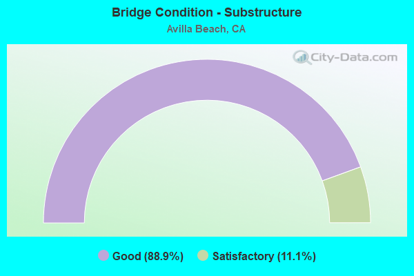
- Bridge Condition - Substructure
- 88.9%Good
- 11.1%Satisfactory
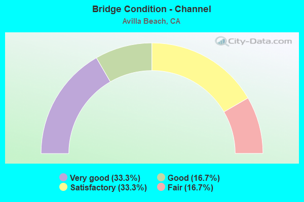
- Bridge Condition - Channel
- 33.3%Very good
- 16.7%Good
- 33.3%Satisfactory
- 16.7%Fair
Find on map >> Show street view
Structure Number: 49 0014L, Location: 05-SLO-101-R21.49 (Lat: 35.184714, Lng: -120.701461), Route carried "on" structure: US 101, Year Built: 1948, Year Reconstructed: 2002, Status: Open, Structure Length: 17.37m (56.99ft), Average Daily Traffic: 31,000 (year 2009), Truck Traffic: 9%, Average Future Daily Traffic: 46,189 (year 2037), Design Load: HS 20, Features Intersected: SAN LUIS OBISPO CREEK
Minimum Vertical Clearance: 30+ m (98+ ft), Kilometerpoint: 21.490, Lanes on structure: 2, Base Highway Network: Yes (Inventory Route: 1, Subroute: 1), Owner: State Highway Agency, Approaching Roadway Width: 10.4m (34.1ft), Skew: 4 degrees, Material/Design: Concrete continuous, Design/Construction: Tee Beam, Number Of Spans In Main Unit: 16, Length of Maximum Span: 13.7m (44.9ft), Curb-To-Curb Width: 11.7m (38.4ft), Out-to-Out Width: 12.8m (42.0ft)
Condition: Deck: Good, Superstructure: Good, Substructure: Good, Channel: Satisfactory, Operating Rating: 25.3 metric tons, Method Used To Determine Operating Rating: Load and Resistance Factor Rating (LRFR) rating reported by rating factor(RF) method using HL-93 loadings, Inventory Rating: 17.8 metric tons, Method Used To Determine Inventory Rating: Load and Resistance Factor Rating (LRFR) rating reported by rating factor(RF) method using HL-93 loadings, Structural Evaluation: Meets minimum limits, Deck Geometry: Better than present minimum criteria, Waterway Adequacy: Equal to present minimum criteria, Approach Roadway Alignment: Equal to present desirable criteria, Designated Inspection Frequency: Every 24 months, Inspection Date: July 2020, Deck Structure Type: Concrete Cast-file-Place
Find on map >> Show street view
Structure Number: 49 0014R, Location: 05-SLO-101-R21.49 (Lat: 35.184900, Lng: -120.701206), Route carried "on" structure: US 101, Year Built: 1940, Year Reconstructed: 1977, Status: Open, Structure Length: 17.37m (56.99ft), Average Daily Traffic: 31,000 (year 2009), Truck Traffic: 9%, Average Future Daily Traffic: 46,189 (year 2037), Features Intersected: SAN LUIS OBISPO CREEK
Minimum Vertical Clearance: 30+ m (98+ ft), Kilometerpoint: 21.490, Lanes on structure: 2, Base Highway Network: Yes (Inventory Route: 1, Subroute: 1), Owner: State Highway Agency, Approaching Roadway Width: 11.6m (38.1ft), Skew: 4 degrees, Material/Design: Concrete continuous, Design/Construction: Tee Beam, Number Of Spans In Main Unit: 16, Length of Maximum Span: 13.7m (44.9ft), Curb-To-Curb Width: 11.7m (38.4ft), Out-to-Out Width: 12.7m (41.7ft)
Condition: Deck: Good, Superstructure: Good, Substructure: Good, Channel: Satisfactory, Operating Rating: 48.9 metric tons, Method Used To Determine Operating Rating: Load Factor (LF), Inventory Rating: 29.2 metric tons, Method Used To Determine Inventory Rating: Load Factor (LF), Structural Evaluation: Better than present minimum criteria, Deck Geometry: Better than present minimum criteria, Waterway Adequacy: Equal to present minimum criteria, Approach Roadway Alignment: Equal to present desirable criteria, Designated Inspection Frequency: Every 24 months, Inspection Date: July 2020, Deck Structure Type: Concrete Cast-file-Place
Find on map >> Show street view
Structure Number: 49 0191L, Location: 05-SLO-101-R21.10 (Lat: 35.179594, Lng: -120.699308), Route carried "on" structure: US 101, Year Built: 1963, Year Reconstructed: 2006, Status: Open, Structure Length: 4.58m (15.03ft), Average Daily Traffic: 31,000 (year 2009), Truck Traffic: 9%, Average Future Daily Traffic: 46,189 (year 2037), Design Load: HS 20, Features Intersected: AVILA BEACH DR
Minimum Vertical Clearance: 30+ m (98+ ft), Kilometerpoint: 21.100, Lanes on structure: 3, Lanes under structure: 2, Base Highway Network: Yes (Inventory Route: 1, Subroute: 1), Owner: State Highway Agency, Approaching Roadway Width: 16.8m (55.1ft), Skew: 3 degrees, Material/Design: Concrete continuous, Design/Construction: Box Beam or Girders - Multiple, Number Of Spans In Main Unit: 3, Length of Maximum Span: 21.4m (70.2ft), Curb-To-Curb Width: 16.8m (55.1ft), Out-to-Out Width: 17.7m (58.1ft)
Condition: Deck: Good, Superstructure: Good, Substructure: Good, Operating Rating: 42.8 metric tons, Method Used To Determine Operating Rating: Load and Resistance Factor Rating (LRFR) rating reported by rating factor(RF) method using HL-93 loadings, Inventory Rating: 30.8 metric tons, Method Used To Determine Inventory Rating: Load and Resistance Factor Rating (LRFR) rating reported by rating factor(RF) method using HL-93 loadings, Structural Evaluation: Better than present minimum criteria, Deck Geometry: Superior to present desirable criteria, Underclear: Meets minimum limits, Approach Roadway Alignment: Equal to present desirable criteria, Designated Inspection Frequency: Every 24 months, Inspection Date: July 2020, Deck Structure Type: Concrete Cast-file-Place, Wearing Surface/Protective System: Wearing Surface: Bituminous
Find on map >> Show street view
Structure Number: 49 0191R, Location: 05-SLO-101-R21.10 (Lat: 35.179506, Lng: -120.698986), Route carried "on" structure: US 101, Year Built: 1963, Status: Open, Structure Length: 5.14m (16.86ft), Average Daily Traffic: 31,000 (year 2009), Truck Traffic: 9%, Average Future Daily Traffic: 46,189 (year 2037), Design Load: HS 20, Features Intersected: AVILA BEACH DR
Minimum Vertical Clearance: 30+ m (98+ ft), Kilometerpoint: 21.100, Lanes on structure: 2, Lanes under structure: 2, Base Highway Network: Yes (Inventory Route: 1, Subroute: 1), Owner: State Highway Agency, Approaching Roadway Width: 10.7m (35.1ft), Skew: 3 degrees, Material/Design: Concrete continuous, Design/Construction: Box Beam or Girders - Multiple, Number Of Spans In Main Unit: 3, Length of Maximum Span: 23.0m (75.5ft), Curb-To-Curb Width: 11.3m (37.1ft), Out-to-Out Width: 12.2m (40.0ft)
Condition: Deck: Good, Superstructure: Good, Substructure: Good, Operating Rating: 34.7 metric tons, Method Used To Determine Operating Rating: Load and Resistance Factor Rating (LRFR) rating reported by rating factor(RF) method using HL-93 loadings, Inventory Rating: 26.9 metric tons, Method Used To Determine Inventory Rating: Load and Resistance Factor Rating (LRFR) rating reported by rating factor(RF) method using HL-93 loadings, Structural Evaluation: Equal to present minimum criteria, Deck Geometry: Equal to present minimum criteria, Underclear: High priority of corrective action, Approach Roadway Alignment: Equal to present desirable criteria, Designated Inspection Frequency: Every 24 months, Inspection Date: July 2020, Deck Structure Type: Concrete Cast-file-Place, Wearing Surface/Protective System: Wearing Surface: Bituminous
Find on map >> Show street view
Structure Number: 49 0192, Location: 05-SLO-101-R22.30 (Lat: 35.196053, Lng: -120.699831), Route carried "on" structure: County highway , Year Built: 1963, Status: Open, Structure Length: 7.01m (23.00ft), Average Daily Traffic: 6,321 (year 2014), Truck Traffic: 8%, Average Future Daily Traffic: 9,502 (year 2037), Design Load: HS 20+Mod, Features Intersected: US HIGHWAY 101, Facility Carried by Structure: SAN LUIS BAY DR
Minimum Vertical Clearance: 30+ m (98+ ft), Kilometerpoint: 0.000, Lanes on structure: 2, Lanes under structure: 4, Owner: State Highway Agency, Approaching Roadway Width: 8.5m (27.9ft), Skew: 1 degrees, Material/Design: Prestressed concrete continuous, Design/Construction: Stringer/Multi-beam, Number Of Spans In Main Unit: 2, Number Of Approach Spans: 2, Length of Maximum Span: 25.3m (83.0ft), Curb or Sidewalk Widths: Left: 0.6m (2.0ft), Right: 1.5m (4.9ft), Curb-To-Curb Width: 8.5m (27.9ft), Out-to-Out Width: 11.3m (37.1ft)
Condition: Deck: Good, Superstructure: Good, Substructure: Good, Operating Rating: 26.6 metric tons, Method Used To Determine Operating Rating: Load and Resistance Factor Rating (LRFR) rating reported by rating factor(RF) method using HL-93 loadings, Inventory Rating: 18.5 metric tons, Method Used To Determine Inventory Rating: Load and Resistance Factor Rating (LRFR) rating reported by rating factor(RF) method using HL-93 loadings, Structural Evaluation: Meets minimum limits, Deck Geometry: Meets minimum limits, Underclear: Meets minimum limits, Approach Roadway Alignment: Better than present minimum criteria, Designated Inspection Frequency: Every 24 months, Inspection Date: July 2020, Deck Structure Type: Concrete Cast-file-Place
Find on map >> Show street view
Structure Number: 49C0261, Location: 0.25 MI S/O SAN LUIS B DR (Lat: 35.192661, Lng: -120.693028), Route carried "on" structure: County highway , Year Built: 1958, Status: Posted for load, Structure Length: 0.94m (3.08ft), Average Daily Traffic: 200 (year 2010), Truck Traffic: 5%, Average Future Daily Traffic: 777 (year 2041), Features Intersected: SQUIRE CREEK, Facility Carried by Structure: MONTE RD
Minimum Vertical Clearance: 30+ m (98+ ft), Kilometerpoint: 0.000, Lanes on structure: 2, Owner: County Highway Agency, Approaching Roadway Width: 5.4m (17.7ft), Material/Design: Wood or Timber, Design/Construction: Stringer/Multi-beam, Number Of Spans In Main Unit: 2, Length of Maximum Span: 4.9m (16.1ft), Curb-To-Curb Width: 5.4m (17.7ft), Out-to-Out Width: 5.5m (18.0ft)
Condition: Deck: Good, Superstructure: Satisfactory, Substructure: Good, Channel: Good, Operating Rating: 13.0 metric tons, Method Used To Determine Operating Rating: Allowable Stress (AS), Inventory Rating: 9.4 metric tons, Method Used To Determine Inventory Rating: Allowable Stress (AS), Structural Evaluation: High priority of corrective action, Deck Geometry: High priority of replacement, Waterway Adequacy: Equal to present desirable criteria, Approach Roadway Alignment: Equal to present minimum criteria, Bridge Posting: Required (Relationship of Operating Rating to Maximum Legal Load: > 39.9% below), Designated Inspection Frequency: Every 24 months, Inspection Date: July 2021, Deck Structure Type: Wood or Timber, Wearing Surface/Protective System: Wearing Surface: Wood or Timber
Find on map >> Show street view
Structure Number: 49C0327, Location: AVILA RD (Lat: 35.179111, Lng: -120.738386), Route carried "on" structure: County highway , Year Built: 1967, Status: Open, Structure Length: 14.63m (48.00ft), Average Daily Traffic: 7,434 (year 2010), Truck Traffic: 3%, Average Future Daily Traffic: 14,034 (year 2040), Design Load: H 20, Features Intersected: SAN LUIS OBISPO CREEK, Facility Carried by Structure: AVILA BEACH DR
Minimum Vertical Clearance: 30+ m (98+ ft), Kilometerpoint: 0.000, Lanes on structure: 2, Owner: County Highway Agency, Approaching Roadway Width: 8.5m (27.9ft), Material/Design: Prestressed concrete continuous, Design/Construction: Stringer/Multi-beam, Number Of Spans In Main Unit: 8, Length of Maximum Span: 18.3m (60.0ft), Curb or Sidewalk Widths: Left: 0.6m (2.0ft), Right: 1.5m (4.9ft), Curb-To-Curb Width: 8.5m (27.9ft), Out-to-Out Width: 11.4m (37.4ft)
Condition: Deck: Satisfactory, Superstructure: Good, Substructure: Satisfactory, Channel: Very good, Operating Rating: 79.8 metric tons, Method Used To Determine Operating Rating: Load Factor (LF), Inventory Rating: 32.6 metric tons, Method Used To Determine Inventory Rating: Load Factor (LF), Structural Evaluation: Equal to present minimum criteria, Deck Geometry: Meets minimum limits, Waterway Adequacy: Superior to present desirable criteria, Approach Roadway Alignment: Equal to present desirable criteria, Designated Inspection Frequency: Every 48 months, Inspection Date: December 2020, Deck Structure Type: Concrete Cast-file-Place, Wearing Surface/Protective System: Wearing Surface: Integral Concrete
Find on map >> Show street view
Structure Number: 49C0328, Location: 0.15 MI E S.R. 1 (Lat: 35.195847, Lng: -120.697211), Route carried "on" structure: County highway , Year Built: 1964, Status: Open, Structure Length: 3.17m (10.40ft), Average Daily Traffic: 7,475 (year 2006), Truck Traffic: 3%, Average Future Daily Traffic: 7,500 (year 2040), Design Load: HS 20, Features Intersected: SAN LUIS OBISPO CREEK, Facility Carried by Structure: SAN LUIS BAY DRIVE
Minimum Vertical Clearance: 30+ m (98+ ft), Kilometerpoint: 0.000, Lanes on structure: 2, Owner: County Highway Agency, Approaching Roadway Width: 8.6m (28.2ft), Material/Design: Concrete continuous, Design/Construction: Tee Beam, Number Of Spans In Main Unit: 3, Length of Maximum Span: 12.2m (40.0ft), Curb or Sidewalk Widths: Left: 0.6m (2.0ft), Right: 0.6m (2.0ft), Curb-To-Curb Width: 8.6m (28.2ft), Out-to-Out Width: 10.4m (34.1ft)
Condition: Deck: Satisfactory, Superstructure: Good, Substructure: Good, Channel: Fair, Operating Rating: 42.1 metric tons, Method Used To Determine Operating Rating: Load and Resistance Factor Rating (LRFR) rating reported by rating factor(RF) method using HL-93 loadings, Inventory Rating: 30.5 metric tons, Method Used To Determine Inventory Rating: Load and Resistance Factor Rating (LRFR) rating reported by rating factor(RF) method using HL-93 loadings, Structural Evaluation: Better than present minimum criteria, Deck Geometry: High priority of replacement, Waterway Adequacy: Better than present minimum criteria, Approach Roadway Alignment: Equal to present desirable criteria, Designated Inspection Frequency: Every 24 months, Inspection Date: September 2020, Deck Structure Type: Concrete Cast-file-Place, Wearing Surface/Protective System: Wearing Surface: Bituminous
Find on map >> Show street view
Structure Number: 49C0438, Location: AVILA RD (Lat: 35.187992, Lng: -120.718942), Route carried "on" structure: County highway , Year Built: 2009, Status: Open, Structure Length: 6.70m (21.98ft), Average Daily Traffic: 500 (year 2010), Truck Traffic: 1%, Average Future Daily Traffic: 900 (year 2039), Design Load: HS 20, Features Intersected: SAN LUIS OBISPO CREEK, Facility Carried by Structure: SAN LUIS BAY DR
Minimum Vertical Clearance: 30+ m (98+ ft), Kilometerpoint: 0.000, Lanes on structure: 2, Owner: County Highway Agency, Approaching Roadway Width: 13.4m (44.0ft), Material/Design: Prestressed concrete continuous, Design/Construction: Box Beam or Girders - Multiple, Number Of Spans In Main Unit: 2, Length of Maximum Span: 33.0m (108.3ft), Curb-To-Curb Width: 13.4m (44.0ft), Out-to-Out Width: 14.3m (46.9ft)
Condition: Deck: Fair, Superstructure: Good, Substructure: Good, Channel: Very good, Operating Rating: 54.1 metric tons, Method Used To Determine Operating Rating: Assigned rating based on Load Factor Design (LFD) reported in metric tons, Inventory Rating: 32.4 metric tons, Method Used To Determine Inventory Rating: Assigned rating based on Load Factor Design (LFD) reported in metric tons, Structural Evaluation: Better than present minimum criteria, Deck Geometry: Superior to present desirable criteria, Waterway Adequacy: Equal to present desirable criteria, Approach Roadway Alignment: Equal to present desirable criteria, Designated Inspection Frequency: Every 24 months, Inspection Date: April 2021, Deck Structure Type: Concrete Cast-file-Place
Find on map >> Show street view
Structure Number: 49 0191L, Location: 05-SLO-101-R21.10 (Lat: 35.179594, Lng: -120.699308), Route carried "under" structure: City street , Year Built: 1963, Structure Length: 0. m, Average Daily Traffic: 10,349 (year 2014), Truck Traffic: 5%, Features Intersected: AVILA BEACH DR, Facility Carried by Structure: US HIGHWAY 101 SB
Minimum Vertical Clearance: 5.00m (16.40ft), Kilometerpoint: 0.000, Lanes on structure: 3, Lanes under structure: 2, Material/Design: Concrete continuous, Design/Construction: Box Beam or Girders - Multiple, Length of Maximum Span: 21.4m (70.2ft)
Find on map >> Show street view
Structure Number: 49 0191R, Location: 05-SLO-101-R21.10 (Lat: 35.179506, Lng: -120.698986), Route carried "under" structure: City street , Year Built: 1963, Structure Length: 0. m, Average Daily Traffic: 10,349 (year 2014), Truck Traffic: 5%, Features Intersected: AVILA BEACH DR, Facility Carried by Structure: US HIGHWAY 101 NB
Minimum Vertical Clearance: 5.61m (18.41ft), Kilometerpoint: 0.000, Lanes on structure: 2, Lanes under structure: 2, Material/Design: Concrete continuous, Design/Construction: Box Beam or Girders - Multiple, Length of Maximum Span: 23.0m (75.5ft)
Find on map >> Show street view
Structure Number: 49 0192, Location: 05-SLO-101-R22.30 (Lat: 35.196053, Lng: -120.699831), Route carried "under" structure: US 101, Year Built: 1963, Structure Length: 0. m, Average Daily Traffic: 62,000 (year 2009), Truck Traffic: 9%, Features Intersected: US HIGHWAY 101, Facility Carried by Structure: SAN LUIS BAY DR
Minimum Vertical Clearance: 5.41m (17.75ft), Kilometerpoint: 22.300, Lanes on structure: 2, Lanes under structure: 4, Material/Design: Prestressed concrete continuous, Design/Construction: Stringer/Multi-beam, Length of Maximum Span: 25.3m (83.0ft)