Bridge Statistics for Aurora, Indiana (IN)
Condition, Traffic, Stress, Structural Evaluation, Project Costs
- National Bridge Inventory (NBI) Statistics
- 31Number of bridges
- 348ft / 106mTotal length
- $953,000Total costs
- 136,185Total average daily traffic
- 9,135Total average daily truck traffic
- National Bridge Inventory (NBI) Registered Bridges for Aurora
- No street view available for this location
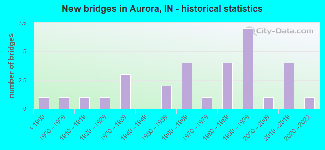
- New bridges - historical statistics
- 1Before 1900
- 11900-1909
- 11910-1919
- 11920-1929
- 31930-1939
- 21950-1959
- 41960-1969
- 11970-1979
- 41980-1989
- 71990-1999
- 12000-2009
- 42010-2019
- 12020-2022

- Reconstructed bridges - Historical Statistics
- 21970-1979
- 41980-1989
- 01990-1999
- 12000-2009
- 12010-2019
- 12020-2022


- Bridge Condition - Deck
- 5.0%Excellent
- 20.0%Very good
- 30.0%Good
- 25.0%Satisfactory
- 15.0%Fair
- 5.0%Poor

- Bridge Condition - Superstructure
- 10.0%Excellent
- 15.0%Very good
- 35.0%Good
- 30.0%Satisfactory
- 5.0%Poor
- 5.0%Serious

- Bridge Condition - Substructure
- 10.0%Excellent
- 5.0%Very good
- 35.0%Good
- 25.0%Satisfactory
- 20.0%Fair
- 5.0%Serious

- Bridge Condition - Channel
- 7.1%Very good
- 25.0%Good
- 25.0%Satisfactory
- 35.7%Fair
- 7.1%Poor

- Bridge Condition - Culverts
- 33.3%Good
- 44.4%Satisfactory
- 22.2%Fair
Find on map >> Show street view
Structure Number: 18758, Location: 01.43 W SR 56 & SR 350 (Lat: 39.048181, Lng: -84.922997), Route carried "on" structure: US 50, Year Built: 1957, Status: Open, Structure Length: 1.26m (4.13ft), Average Daily Traffic: 14,576 (year 2004), Truck Traffic: 10%, Average Future Daily Traffic: 20,753 (year 2032), Features Intersected: STONY LONESOME CREEK
Minimum Vertical Clearance: 30+ m (98+ ft), Kilometerpoint: 18.894, Lanes on structure: 4, Base Highway Network: Yes (, Subroute: 1), Owner: State Highway Agency, Approaching Roadway Width: 16.2m (53.1ft), Skew: 24 degrees, Material/Design: Steel, Design/Construction: Culvert, Number Of Spans In Main Unit: 2, Length of Maximum Span: 5.2m (17.1ft)
Condition: Channel: Satisfactory, Culverts: Satisfactory, Structural Evaluation: Equal to present minimum criteria, Waterway Adequacy: Somewhat better than minimum adequacy, Approach Roadway Alignment: Equal to present desirable criteria, Designated Inspection Frequency: Every 24 months, Inspection Date: August 2021
Find on map >> Show street view
Structure Number: 1876, Location: 01.05 W SR 56/350 (Lat: 39.052200, Lng: -84.920581), Route carried "on" structure: US 50, Year Built: 1962, Year Reconstructed: 2012, Status: Open, Structure Length: 10.70m (35.10ft), Average Daily Traffic: 21,622 (year 2018), Truck Traffic: 5%, Average Future Daily Traffic: 29,123 (year 2038), Design Load: HS 20+Mod, Features Intersected: CSX RR & 2 STREETS
Minimum Vertical Clearance: 30+ m (98+ ft), Kilometerpoint: 19.505, Lanes on structure: 4, Lanes under structure: 4, Base Highway Network: Yes (, Subroute: 1), Owner: State Highway Agency, Approaching Roadway Width: 18.7m (61.4ft), Skew: 29 degrees, Material/Design: Steel continuous, Design/Construction: Stringer/Multi-beam, Number Of Spans In Main Unit: 4, Number Of Approach Spans: 3, Length of Maximum Span: 25.6m (84.0ft), Curb-To-Curb Width: 17.5m (57.4ft), Out-to-Out Width: 19.6m (64.3ft)
Condition: Deck: Good, Superstructure: Satisfactory, Substructure: Good, Operating Rating: 63.5 metric tons, Method Used To Determine Operating Rating: Load Factor (LF), Inventory Rating: 38.1 metric tons, Method Used To Determine Inventory Rating: Load Factor (LF), Structural Evaluation: Equal to present minimum criteria, Deck Geometry: Somewhat better than minimum adequacy, Underclear: High priority of corrective action, Approach Roadway Alignment: Equal to present minimum criteria, Designated Inspection Frequency: Every 24 months, Inspection Date: August 2021, Deck Structure Type: Concrete Cast-file-Place, Wearing Surface/Protective System: Wearing Surface: Epoxy Overlay, Deck Protection: Epoxy Coated Reinforcing
Find on map >> Show street view
Structure Number: 1877, Location: 00.09 E SR 56 (Lat: 39.059239, Lng: -84.901475), Route carried "on" structure: US 50, Year Built: 1952, Year Reconstructed: 1992, Status: Open, Structure Length: 12.33m (40.45ft), Average Daily Traffic: 28,398 (year 2021), Truck Traffic: 10%, Average Future Daily Traffic: 31,872 (year 2041), Design Load: HS 20, Features Intersected: HOGAN CREEK
Minimum Vertical Clearance: 30+ m (98+ ft), Kilometerpoint: 21.340, Lanes on structure: 5, Base Highway Network: Yes (, Subroute: 1), Owner: State Highway Agency, Approaching Roadway Width: 17.7m (58.1ft), Skew: 1 degrees, Material/Design: Steel continuous, Design/Construction: Stringer/Multi-beam, Number Of Spans In Main Unit: 5, Number Of Approach Spans: 2, Length of Maximum Span: 20.7m (67.9ft), Curb or Sidewalk Widths: Left: 1.5m (4.9ft), Right: 1.5m (4.9ft), Curb-To-Curb Width: 20.7m (67.9ft), Out-to-Out Width: 24.7m (81.0ft)
Condition: Deck: Fair, Superstructure: Satisfactory, Substructure: Fair, Channel: Good, Operating Rating: 38.2 metric tons, Method Used To Determine Operating Rating: Load and Resistance Factor Rating (LRFR) rating reported by rating factor(RF) method using HL-93 loadings, Inventory Rating: 29.5 metric tons, Method Used To Determine Inventory Rating: Load and Resistance Factor Rating (LRFR) rating reported by rating factor(RF) method using HL-93 loadings, Structural Evaluation: Somewhat better than minimum adequacy, Deck Geometry: Somewhat better than minimum adequacy, Waterway Adequacy: Better than present minimum criteria, Approach Roadway Alignment: Equal to present desirable criteria, Designated Inspection Frequency: Every 24 months, Underwater Inspection Frequency: Every 60 months, Inspection Date: August 2021, Underwater Inspection Date: October 2021, Deck Structure Type: Concrete Cast-file-Place, Wearing Surface/Protective System: Wearing Surface: Latex Concrete, Deck Protection: Epoxy Coated Reinforcing
Find on map >> Show street view
Structure Number: 1878, Location: 00.86 E SR 148 (Lat: 39.075600, Lng: -84.892261), Route carried "on" structure: US 50, Year Built: 1935, Year Reconstructed: 1988, Status: Open, Structure Length: 1.89m (6.20ft), Average Daily Traffic: 35,211 (year 2004), Truck Traffic: 5%, Average Future Daily Traffic: 50,612 (year 2030), Design Load: H 20, Features Intersected: WILSON CREEK
Minimum Vertical Clearance: 30+ m (98+ ft), Kilometerpoint: 23.368, Lanes on structure: 4, Base Highway Network: Yes (, Subroute: 1), Owner: State Highway Agency, Approaching Roadway Width: 18.3m (60.0ft), Skew: 2 degrees, Material/Design: Concrete, Design/Construction: Culvert, Number Of Spans In Main Unit: 1, Length of Maximum Span: 18.3m (60.0ft)
Condition: Channel: Fair, Culverts: Satisfactory, Inventory Rating: 88.2 metric tons, Method Used To Determine Inventory Rating: Field evaluation and documented engineering judgment, Structural Evaluation: Equal to present minimum criteria, Waterway Adequacy: Equal to present minimum criteria, Approach Roadway Alignment: Equal to present desirable criteria, Designated Inspection Frequency: Every 24 months, Inspection Date: August 2021
Find on map >> Show street view
Structure Number: 2935, Location: 00.12 S SR 46 (Lat: 39.304981, Lng: -85.218850), Route carried "on" structure: State highway 229, Year Built: 2015, Status: Open, Structure Length: 0.91m (2.99ft), Average Daily Traffic: 8,460 (year 2009), Truck Traffic: 1%, Average Future Daily Traffic: 10,680 (year 2029), Design Load: HL 93, Features Intersected: UNT LITTLE LAUGHERY CREK
Minimum Vertical Clearance: 30+ m (98+ ft), Kilometerpoint: 13.454, Lanes on structure: 2, Owner: State Highway Agency, Approaching Roadway Width: 7.9m (25.9ft), Material/Design: Concrete, Design/Construction: Culvert, Number Of Spans In Main Unit: 1, Length of Maximum Span: 8.5m (27.9ft), Curb or Sidewalk Widths: Left: 1.8m (5.9ft), Right: 1.8m (5.9ft), Curb-To-Curb Width: 7.9m (25.9ft), Out-to-Out Width: 7.9m (25.9ft)
Condition: Channel: Very good, Culverts: Good, Operating Rating: 54.5 metric tons, Method Used To Determine Operating Rating: Field evaluation and documented engineering judgment, Inventory Rating: 32.7 metric tons, Method Used To Determine Inventory Rating: Field evaluation and documented engineering judgment, Structural Evaluation: Better than present minimum criteria, Deck Geometry: High priority of replacement, Waterway Adequacy: Equal to present desirable criteria, Approach Roadway Alignment: Equal to present desirable criteria, Designated Inspection Frequency: Every 24 months, Inspection Date: June 2020
Find on map >> Show street view
Structure Number: 3188, Location: 00.10 W US 50 (Lat: 39.058800, Lng: -84.904500), Route carried "on" structure: State highway 350, Year Built: 1981, Year Reconstructed: 2020, Status: Open, Structure Length: 9.25m (30.35ft), Average Daily Traffic: 10,240 (year 2018), Truck Traffic: 4%, Average Future Daily Traffic: 10,300 (year 2038), Design Load: HS 20, Features Intersected: SOUTH HOGAN CREEK
Minimum Vertical Clearance: 30+ m (98+ ft), Kilometerpoint: 19.248, Lanes on structure: 3, Owner: State Highway Agency, Approaching Roadway Width: 12.2m (40.0ft), Material/Design: Prestressed concrete continuous, Design/Construction: Stringer/Multi-beam, Number Of Spans In Main Unit: 3, Length of Maximum Span: 38.1m (125.0ft), Curb or Sidewalk Widths: Left: 1.7m (5.6ft), Right: 0.0m, Curb-To-Curb Width: 12.2m (40.0ft), Out-to-Out Width: 14.6m (47.9ft)
Condition: Deck: Satisfactory, Superstructure: Good, Substructure: Fair, Channel: Good, Operating Rating: 33.0 metric tons, Method Used To Determine Operating Rating: Load and Resistance Factor Rating (LRFR) rating reported by rating factor(RF) method using HL-93 loadings, Inventory Rating: 24.3 metric tons, Method Used To Determine Inventory Rating: Load and Resistance Factor Rating (LRFR) rating reported by rating factor(RF) method using HL-93 loadings, Structural Evaluation: Somewhat better than minimum adequacy, Deck Geometry: Meets minimum limits, Waterway Adequacy: Better than present minimum criteria, Approach Roadway Alignment: Equal to present desirable criteria, Designated Inspection Frequency: Every 24 months, Underwater Inspection Frequency: Every 60 months, Inspection Date: October 2021, Underwater Inspection Date: October 2018, Deck Structure Type: Concrete Cast-file-Place, Wearing Surface/Protective System: Wearing Surface: Latex Concrete, Deck Protection: Epoxy Coated Reinforcing
Find on map >> Show street view
Structure Number: 1500001, Location: 00.60 S OF MT TABOR RD (Lat: 39.014950, Lng: -84.980519), Route carried "on" structure: County highway , Year Built: 1992, Status: Open, Structure Length: 1.13m (3.71ft), Average Daily Traffic: 860 (year 2017), Truck Traffic: 10%, Average Future Daily Traffic: 1,280 (year 2037), Design Load: HS 20, Features Intersected: BRANCH OF LAUGHERY CREEK, Facility Carried by Structure: HUESMAN RD
Minimum Vertical Clearance: 30+ m (98+ ft), Kilometerpoint: 0.000, Lanes on structure: 2, Owner: County Highway Agency, Approaching Roadway Width: 6.7m (22.0ft), Skew: 4 degrees, Material/Design: Concrete, Design/Construction: Stringer/Multi-beam, Number Of Spans In Main Unit: 1, Length of Maximum Span: 10.4m (34.1ft), Curb-To-Curb Width: 6.8m (22.3ft), Out-to-Out Width: 7.3m (24.0ft)
Condition: Deck: Satisfactory, Superstructure: Satisfactory, Substructure: Satisfactory, Channel: Fair, Operating Rating: 40.8 metric tons, Method Used To Determine Operating Rating: Field evaluation and documented engineering judgment, Inventory Rating: 32.7 metric tons, Method Used To Determine Inventory Rating: Field evaluation and documented engineering judgment, Structural Evaluation: Equal to present minimum criteria, Deck Geometry: Meets minimum limits, Waterway Adequacy: Equal to present minimum criteria, Approach Roadway Alignment: Equal to present minimum criteria, Designated Inspection Frequency: Every 24 months, Inspection Date: April 2021, Deck Structure Type: Concrete Cast-file-Place, Wearing Surface/Protective System: Wearing Surface: Bituminous
Find on map >> Show street view
Structure Number: 1500002, Location: 00.50 W OF GATCH HILL (Lat: 38.999789, Lng: -84.969200), Route carried "on" structure: County highway , Year Built: 1935, Year Reconstructed: 1984, Status: Posted for load, Structure Length: 1.13m (3.71ft), Average Daily Traffic: 140 (year 2017), Truck Traffic: 10%, Average Future Daily Traffic: 210 (year 2037), Features Intersected: BRANCH OF LAUGHERY CREEK, Facility Carried by Structure: E LAUGHERY CR RD
Minimum Vertical Clearance: 30+ m (98+ ft), Kilometerpoint: 0.000, Lanes on structure: 1, Owner: County Highway Agency, Approaching Roadway Width: 4.7m (15.4ft), Material/Design: Steel, Design/Construction: Stringer/Multi-beam, Number Of Spans In Main Unit: 1, Length of Maximum Span: 9.1m (29.9ft), Curb-To-Curb Width: 4.7m (15.4ft), Out-to-Out Width: 4.7m (15.4ft)
Condition: Deck: Satisfactory, Superstructure: Satisfactory, Substructure: Fair, Channel: Fair, Operating Rating: 34.2 metric tons, Method Used To Determine Operating Rating: Load Factor (LF), Inventory Rating: 20.5 metric tons, Method Used To Determine Inventory Rating: Load Factor (LF), Structural Evaluation: Somewhat better than minimum adequacy, Deck Geometry: High priority of replacement, Waterway Adequacy: Meets minimum limits, Approach Roadway Alignment: High priority of corrective action, Designated Inspection Frequency: Every 24 months, Inspection Date: April 2021, Deck Structure Type: Concrete Cast-file-Place, Wearing Surface/Protective System: Wearing Surface: Bituminous
Find on map >> Show street view
Structure Number: 1500003, Location: 00.40 W OF SR 56 (Lat: 39.026381, Lng: -84.896519), Route carried "on" structure: County highway , Year Built: 1993, Status: Open, Structure Length: 0.88m (2.89ft), Average Daily Traffic: 100 (year 2017), Truck Traffic: 10%, Average Future Daily Traffic: 150 (year 2037), Design Load: HS 20, Features Intersected: BRANCH OF LAUGHERY CREEK, Facility Carried by Structure: E LAUGHERY CR RD
Minimum Vertical Clearance: 30+ m (98+ ft), Kilometerpoint: 0.000, Lanes on structure: 2, Owner: County Highway Agency, Approaching Roadway Width: 6.1m (20.0ft), Material/Design: Concrete, Design/Construction: Stringer/Multi-beam, Number Of Spans In Main Unit: 1, Length of Maximum Span: 7.9m (25.9ft), Curb-To-Curb Width: 7.2m (23.6ft), Out-to-Out Width: 7.6m (24.9ft)
Condition: Deck: Good, Superstructure: Good, Substructure: Satisfactory, Channel: Fair, Operating Rating: 40.8 metric tons, Method Used To Determine Operating Rating: Field evaluation and documented engineering judgment, Inventory Rating: 32.7 metric tons, Method Used To Determine Inventory Rating: Field evaluation and documented engineering judgment, Structural Evaluation: Equal to present minimum criteria, Deck Geometry: Somewhat better than minimum adequacy, Waterway Adequacy: Equal to present minimum criteria, Approach Roadway Alignment: Equal to present minimum criteria, Designated Inspection Frequency: Every 24 months, Inspection Date: April 2021, Deck Structure Type: Concrete Cast-file-Place, Wearing Surface/Protective System: Wearing Surface: Bituminous
Find on map >> Show street view
Structure Number: 1500017, Location: 00.20 S OF PROBST RD (Lat: 39.047419, Lng: -84.970811), Route carried "on" structure: County highway , Year Built: 1991, Status: Open, Structure Length: 7.10m (23.29ft), Average Daily Traffic: 390 (year 2017), Truck Traffic: 10%, Average Future Daily Traffic: 580 (year 2037), Design Load: HS 20, Features Intersected: SOUTH HOGAN CREEK, Facility Carried by Structure: CHESTERVILLE RD
Minimum Vertical Clearance: 30+ m (98+ ft), Kilometerpoint: 0.000, Lanes on structure: 2, Owner: County Highway Agency, Approaching Roadway Width: 6.7m (22.0ft), Skew: 1 degrees, Material/Design: Prestressed concrete continuous, Design/Construction: Stringer/Multi-beam, Number Of Spans In Main Unit: 4, Length of Maximum Span: 18.3m (60.0ft), Curb-To-Curb Width: 7.3m (24.0ft), Out-to-Out Width: 8.2m (26.9ft)
Condition: Deck: Good, Superstructure: Good, Substructure: Good, Channel: Good, Operating Rating: 62.6 metric tons, Method Used To Determine Operating Rating: Load Factor (LF), Inventory Rating: 12.0 metric tons, Method Used To Determine Inventory Rating: Load Factor (LF), Structural Evaluation: Meets minimum limits, Deck Geometry: Somewhat better than minimum adequacy, Waterway Adequacy: Better than present minimum criteria, Approach Roadway Alignment: Equal to present minimum criteria, Designated Inspection Frequency: Every 24 months, Inspection Date: April 2021, Deck Structure Type: Concrete Cast-file-Place, Wearing Surface/Protective System: Wearing Surface: Monolithic Concrete
Find on map >> Show street view
Structure Number: 1500025, Location: 00.30 SE OF SHORT RIDGE (Lat: 39.072289, Lng: -84.957139), Route carried "on" structure: County highway , Year Built: 1915, Year Reconstructed: 1980, Status: Posted for load, Structure Length: 1.22m (4.00ft), Average Daily Traffic: 1,050 (year 2017), Truck Traffic: 5%, Average Future Daily Traffic: 1,560 (year 2037), Features Intersected: BRANCH OF N HOGAN CREEK, Facility Carried by Structure: N HOGAN RD
Minimum Vertical Clearance: 30+ m (98+ ft), Kilometerpoint: 0.000, Lanes on structure: 2, Owner: County Highway Agency, Approaching Roadway Width: 6.1m (20.0ft), Skew: 6 degrees, Material/Design: Steel, Design/Construction: Culvert, Number Of Spans In Main Unit: 1, Length of Maximum Span: 12.2m (40.0ft), Curb-To-Curb Width: 10.4m (34.1ft), Out-to-Out Width: 10.4m (34.1ft)
Condition: Channel: Poor, Culverts: Fair, Operating Rating: 24.5 metric tons, Method Used To Determine Operating Rating: Field evaluation and documented engineering judgment, Inventory Rating: 24.5 metric tons, Method Used To Determine Inventory Rating: Field evaluation and documented engineering judgment, Structural Evaluation: Somewhat better than minimum adequacy, Deck Geometry: Equal to present minimum criteria, Waterway Adequacy: Somewhat better than minimum adequacy, Approach Roadway Alignment: Equal to present minimum criteria, Bridge Posting: Required (Relationship of Operating Rating to Maximum Legal Load: 20.0 - 29.9% below), Designated Inspection Frequency: Every 24 months, Inspection Date: April 2021
Find on map >> Show street view
Structure Number: 1500026, Location: 00.10 N OF SHORT RIDGE (Lat: 39.075650, Lng: -84.962089), Route carried "on" structure: County highway , Year Built: 1906, Status: Posted for load, Structure Length: 0.91m (2.99ft), Average Daily Traffic: 10 (year 2017), Truck Traffic: 10%, Average Future Daily Traffic: 10 (year 2037), Features Intersected: BRANCH OF NORTH HOGAN CR, Facility Carried by Structure: RED BRIDGE RD
Minimum Vertical Clearance: 30+ m (98+ ft), Kilometerpoint: 0.000, Lanes on structure: 2, Owner: County Highway Agency, Approaching Roadway Width: 5.5m (18.0ft), Material/Design: Steel continuous, Design/Construction: Stringer/Multi-beam, Number Of Spans In Main Unit: 2, Length of Maximum Span: 4.4m (14.4ft), Curb-To-Curb Width: 6.8m (22.3ft), Out-to-Out Width: 6.9m (22.6ft)
Condition: Deck: Poor, Superstructure: Serious, Substructure: Serious, Channel: Fair, Operating Rating: 13.4 metric tons, Method Used To Determine Operating Rating: Load Factor (LF), Inventory Rating: 8.0 metric tons, Method Used To Determine Inventory Rating: Load Factor (LF), Structural Evaluation: High priority of replacement, Deck Geometry: Somewhat better than minimum adequacy, Waterway Adequacy: Somewhat better than minimum adequacy, Approach Roadway Alignment: Equal to present minimum criteria, Bridge Posting: Required (Relationship of Operating Rating to Maximum Legal Load: > 39.9% below), Length Of Structure Improvement: 1.59m (5.22ft), Designated Inspection Frequency: Every 12 months, Inspection Date: April 2021, Bridge Improvement Cost: $224,000, Roadway Improvement Cost: $169,000, Total Project Cost: $496,000 ( Estimate for 2017), Deck Structure Type: Concrete Cast-file-Place, Wearing Surface/Protective System: Wearing Surface: Bituminous
Find on map >> Show street view
Structure Number: 1500027, Location: 00.10 S OF CROSS RD (Lat: 39.076139, Lng: -84.960300), Route carried "on" structure: County highway , Year Built: 1997, Status: Open, Structure Length: 6.46m (21.19ft), Average Daily Traffic: 1,050 (year 2017), Truck Traffic: 10%, Average Future Daily Traffic: 1,560 (year 2037), Design Load: HS 20, Features Intersected: NORTH HOGAN CREEK, Facility Carried by Structure: N HOGAN ROAD
Minimum Vertical Clearance: 30+ m (98+ ft), Kilometerpoint: 0.000, Lanes on structure: 2, Owner: County Highway Agency, Approaching Roadway Width: 8.8m (28.9ft), Skew: 3 degrees, Material/Design: Prestressed concrete continuous, Design/Construction: Stringer/Multi-beam, Number Of Spans In Main Unit: 3, Length of Maximum Span: 22.6m (74.1ft), Curb-To-Curb Width: 8.5m (27.9ft), Out-to-Out Width: 9.4m (30.8ft)
Condition: Deck: Good, Superstructure: Good, Substructure: Good, Channel: Good, Operating Rating: 60.7 metric tons, Method Used To Determine Operating Rating: Load Factor (LF), Inventory Rating: 23.7 metric tons, Method Used To Determine Inventory Rating: Load Factor (LF), Structural Evaluation: Equal to present minimum criteria, Deck Geometry: Somewhat better than minimum adequacy, Waterway Adequacy: Better than present minimum criteria, Approach Roadway Alignment: Equal to present desirable criteria, Designated Inspection Frequency: Every 24 months, Inspection Date: April 2021, Deck Structure Type: Concrete Cast-file-Place, Wearing Surface/Protective System: Wearing Surface: Monolithic Concrete
Find on map >> Show street view
Structure Number: 1500028, Location: 00.50 NW OF SOAP HILL (Lat: 39.091669, Lng: -84.965011), Route carried "on" structure: County highway , Year Built: 1977, Status: Open, Structure Length: 1.07m (3.51ft), Average Daily Traffic: 950 (year 2017), Truck Traffic: 10%, Average Future Daily Traffic: 1,410 (year 2037), Features Intersected: ELK RUN, Facility Carried by Structure: N HOGAN RD
Minimum Vertical Clearance: 30+ m (98+ ft), Kilometerpoint: 0.000, Lanes on structure: 2, Owner: County Highway Agency, Approaching Roadway Width: 6.7m (22.0ft), Material/Design: Prestressed concrete, Design/Construction: Box Beam or Girders - Multiple, Number Of Spans In Main Unit: 1, Length of Maximum Span: 10.1m (33.1ft), Curb-To-Curb Width: 8.4m (27.6ft), Out-to-Out Width: 8.6m (28.2ft)
Condition: Deck: Very good, Superstructure: Good, Substructure: Good, Channel: Fair, Operating Rating: 73.7 metric tons, Method Used To Determine Operating Rating: Load Factor (LF), Inventory Rating: 44.1 metric tons, Method Used To Determine Inventory Rating: Load Factor (LF), Structural Evaluation: Better than present minimum criteria, Deck Geometry: Somewhat better than minimum adequacy, Waterway Adequacy: Better than present minimum criteria, Approach Roadway Alignment: Equal to present desirable criteria, Designated Inspection Frequency: Every 24 months, Inspection Date: April 2021, Deck Structure Type: Concrete Cast-file-Place, Wearing Surface/Protective System: Wearing Surface: Monolithic Concrete
Find on map >> Show street view
Structure Number: 1500029, Location: 00.40 E OF UNION RIDGE (Lat: 39.106131, Lng: -84.979069), Route carried "on" structure: County highway , Year Built: 1920, Year Reconstructed: 1976, Status: Posted for load, Structure Length: 0.72m (2.36ft), Average Daily Traffic: 950 (year 2017), Truck Traffic: 10%, Average Future Daily Traffic: 1,410 (year 2037), Features Intersected: BRANCH OF NORTH HOGAN CR, Facility Carried by Structure: N HOGAN RD
Minimum Vertical Clearance: 30+ m (98+ ft), Kilometerpoint: 0.000, Lanes on structure: 2, Owner: County Highway Agency, Approaching Roadway Width: 7.3m (24.0ft), Material/Design: Concrete, Design/Construction: Stringer/Multi-beam, Number Of Spans In Main Unit: 1, Length of Maximum Span: 6.2m (20.3ft), Curb-To-Curb Width: 8.6m (28.2ft), Out-to-Out Width: 9.3m (30.5ft)
Condition: Deck: Fair, Superstructure: Poor, Substructure: Satisfactory, Channel: Fair, Operating Rating: 32.7 metric tons, Method Used To Determine Operating Rating: Field evaluation and documented engineering judgment, Inventory Rating: 24.5 metric tons, Method Used To Determine Inventory Rating: Field evaluation and documented engineering judgment, Structural Evaluation: Meets minimum limits, Deck Geometry: Somewhat better than minimum adequacy, Waterway Adequacy: Equal to present minimum criteria, Approach Roadway Alignment: Equal to present minimum criteria, Length Of Structure Improvement: 1.37m (4.49ft), Designated Inspection Frequency: Every 12 months, Inspection Date: April 2021, Bridge Improvement Cost: $193,000, Roadway Improvement Cost: $169,000, Total Project Cost: $457,000 ( Estimate for 2017), Deck Structure Type: Concrete Cast-file-Place, Wearing Surface/Protective System: Wearing Surface: Bituminous
Find on map >> Show street view
Structure Number: 1500052, Location: 00.20 SW OF SCENIC DR (Lat: 39.099631, Lng: -84.905219), Route carried "on" structure: County highway , Year Built: 1993, Status: Open, Structure Length: 0.85m (2.79ft), Average Daily Traffic: 4,190 (year 2017), Truck Traffic: 10%, Average Future Daily Traffic: 6,210 (year 2037), Design Load: HS 20, Features Intersected: WILSON CREEK, Facility Carried by Structure: WILSON CREEK RD
Minimum Vertical Clearance: 30+ m (98+ ft), Kilometerpoint: 0.000, Lanes on structure: 2, Owner: County Highway Agency, Approaching Roadway Width: 6.4m (21.0ft), Skew: 6 degrees, Material/Design: Steel, Design/Construction: Culvert, Number Of Spans In Main Unit: 1, Length of Maximum Span: 8.5m (27.9ft), Curb-To-Curb Width: 6.4m (21.0ft), Out-to-Out Width: 6.4m (21.0ft)
Condition: Channel: Fair, Culverts: Satisfactory, Inventory Rating: 74.0 metric tons, Method Used To Determine Inventory Rating: Load Factor (LF), Structural Evaluation: Equal to present minimum criteria, Deck Geometry: High priority of replacement, Waterway Adequacy: Equal to present minimum criteria, Approach Roadway Alignment: Equal to present desirable criteria, Designated Inspection Frequency: Every 24 months, Inspection Date: April 2021
Find on map >> Show street view
Structure Number: 1500061, Location: 00.20 NE OF SR 1 (Lat: 39.196700, Lng: -84.905911), Route carried "on" structure: County highway , Year Built: 1987, Status: Open, Structure Length: 2.10m (6.89ft), Average Daily Traffic: 800 (year 2017), Truck Traffic: 10%, Average Future Daily Traffic: 1,190 (year 2037), Design Load: HS 20, Features Intersected: BRUSH FORK TANNERS CREEK, Facility Carried by Structure: SAWDON RIDGE RD
Minimum Vertical Clearance: 30+ m (98+ ft), Kilometerpoint: 0.000, Lanes on structure: 2, Owner: County Highway Agency, Approaching Roadway Width: 6.4m (21.0ft), Skew: 5 degrees, Material/Design: Concrete, Design/Construction: Stringer/Multi-beam, Number Of Spans In Main Unit: 2, Length of Maximum Span: 11.0m (36.1ft), Curb-To-Curb Width: 8.1m (26.6ft), Out-to-Out Width: 8.5m (27.9ft)
Condition: Deck: Fair, Superstructure: Satisfactory, Substructure: Fair, Channel: Fair, Operating Rating: 40.8 metric tons, Method Used To Determine Operating Rating: Field evaluation and documented engineering judgment, Inventory Rating: 32.7 metric tons, Method Used To Determine Inventory Rating: Field evaluation and documented engineering judgment, Structural Evaluation: Somewhat better than minimum adequacy, Deck Geometry: Somewhat better than minimum adequacy, Waterway Adequacy: Better than present minimum criteria, Approach Roadway Alignment: Equal to present minimum criteria, Designated Inspection Frequency: Every 24 months, Inspection Date: April 2021, Deck Structure Type: Concrete Cast-file-Place, Wearing Surface/Protective System: Wearing Surface: Monolithic Concrete
Find on map >> Show street view
Structure Number: 1500068, Location: 00.20 S OF US 50 (Lat: 39.046061, Lng: -84.922961), Route carried "on" structure: Alternate City street , Year Built: 1997, Status: Open, Structure Length: 0.69m (2.26ft), Average Daily Traffic: 230 (year 2017), Truck Traffic: 10%, Average Future Daily Traffic: 340 (year 2037), Features Intersected: BRANCH OF S HOGAN CREEK, Facility Carried by Structure: INDIANA AVE
Minimum Vertical Clearance: 30+ m (98+ ft), Kilometerpoint: 0.000, Lanes on structure: 2, Owner: County Highway Agency, Approaching Roadway Width: 6.7m (22.0ft), Material/Design: Steel, Design/Construction: Culvert, Number Of Spans In Main Unit: 1, Length of Maximum Span: 6.9m (22.6ft), Curb-To-Curb Width: 6.7m (22.0ft), Out-to-Out Width: 6.7m (22.0ft)
Condition: Channel: Fair, Culverts: Good, Inventory Rating: 70.6 metric tons, Method Used To Determine Inventory Rating: Load Factor (LF), Structural Evaluation: Better than present minimum criteria, Deck Geometry: Meets minimum limits, Waterway Adequacy: Equal to present minimum criteria, Approach Roadway Alignment: Equal to present minimum criteria, Designated Inspection Frequency: Every 24 months, Inspection Date: April 2021
Find on map >> Show street view
Structure Number: 1500091, Location: 00.10 N OF SR 56 (Lat: 39.057881, Lng: -84.899261), Route carried "on" structure: Alternate City street , Year Built: 1887, Year Reconstructed: 1989, Status: Posted for load, Structure Length: 7.74m (25.39ft), Average Daily Traffic: 3,050 (year 2017), Truck Traffic: 5%, Average Future Daily Traffic: 4,520 (year 2037), Features Intersected: HOGAN CREEK, Facility Carried by Structure: GEORGE ST
Minimum Vertical Clearance: 5.49m (18.01ft), Kilometerpoint: 0.000, Lanes on structure: 2, Owner: County Highway Agency, Approaching Roadway Width: 7.0m (23.0ft), Material/Design: Aluminum, Iron, Design/Construction: Truss - Thru, Number Of Spans In Main Unit: 1, Number Of Approach Spans: 1, Length of Maximum Span: 60.7m (199.1ft), Curb or Sidewalk Widths: Left: 2.1m (6.9ft), Right: 0.0m, Curb-To-Curb Width: 7.1m (23.3ft), Out-to-Out Width: 7.1m (23.3ft)
Condition: Deck: Satisfactory, Superstructure: Satisfactory, Substructure: Satisfactory, Channel: Satisfactory, Operating Rating: 12.9 metric tons, Method Used To Determine Operating Rating: Load Factor (LF), Inventory Rating: 8.1 metric tons, Method Used To Determine Inventory Rating: Load Factor (LF), Structural Evaluation: High priority of corrective action, Deck Geometry: High priority of replacement, Waterway Adequacy: Better than present minimum criteria, Approach Roadway Alignment: Equal to present minimum criteria, Bridge Posting: Required (Relationship of Operating Rating to Maximum Legal Load: > 39.9% below), Designated Inspection Frequency: Every 24 months, Critical Feature Inspection Frequency: Every 24 months, Other Special Inspection Frequency: Every 24 months, Inspection Date: April 2021, Critical Feature Inspection Date: April 2021, Other Special Inspection Date: April 2020, Deck Structure Type: Open Grating, Wearing Surface/Protective System: Wearing Surface: Other
Find on map >> Show street view
Structure Number: 1500095, Location: 00.10 E OF US 50 (Lat: 39.045169, Lng: -84.922261), Route carried "on" structure: Alternate City street , Year Built: 1930, Status: Open, Structure Length: 1.14m (3.74ft), Average Daily Traffic: 110 (year 2017), Truck Traffic: 10%, Average Future Daily Traffic: 160 (year 2037), Features Intersected: BRANCH OF HOGAN CREEK, Facility Carried by Structure: INDIANA AVENUE
Minimum Vertical Clearance: 30+ m (98+ ft), Kilometerpoint: 0.000, Lanes on structure: 2, Owner: County Highway Agency, Approaching Roadway Width: 5.8m (19.0ft), Skew: 2 degrees, Material/Design: Concrete, Design/Construction: Culvert, Number Of Spans In Main Unit: 1, Length of Maximum Span: 11.4m (37.4ft), Curb-To-Curb Width: 5.8m (19.0ft), Out-to-Out Width: 5.8m (19.0ft)
Condition: Channel: Satisfactory, Culverts: Good, Operating Rating: 40.8 metric tons, Method Used To Determine Operating Rating: Field evaluation and documented engineering judgment, Inventory Rating: 32.7 metric tons, Method Used To Determine Inventory Rating: Field evaluation and documented engineering judgment, Structural Evaluation: Better than present minimum criteria, Deck Geometry: High priority of corrective action, Waterway Adequacy: Equal to present minimum criteria, Approach Roadway Alignment: Equal to present minimum criteria, Designated Inspection Frequency: Every 24 months, Inspection Date: April 2021
Find on map >> Show street view
Structure Number: 1500103, Location: 00.01 W OF GOOSE RUN RD (Lat: 39.077300, Lng: -84.926339), Route carried "on" structure: County highway 88, Year Built: 1960, Status: Open, Structure Length: 1.01m (3.31ft), Average Daily Traffic: 90 (year 2017), Truck Traffic: 2%, Average Future Daily Traffic: 130 (year 2037), Features Intersected: BRANCH OF HOGAN CREEK, Facility Carried by Structure: CROSS RD
Minimum Vertical Clearance: 30+ m (98+ ft), Kilometerpoint: 0.000, Lanes on structure: 2, Owner: County Highway Agency, Approaching Roadway Width: 4.9m (16.1ft), Material/Design: Steel, Design/Construction: Culvert, Number Of Spans In Main Unit: 2, Length of Maximum Span: 4.7m (15.4ft), Curb-To-Curb Width: 5.6m (18.4ft), Out-to-Out Width: 5.6m (18.4ft)
Condition: Channel: Poor, Culverts: Satisfactory, Operating Rating: 32.7 metric tons, Method Used To Determine Operating Rating: Field evaluation and documented engineering judgment, Inventory Rating: 32.7 metric tons, Method Used To Determine Inventory Rating: Field evaluation and documented engineering judgment, Structural Evaluation: Equal to present minimum criteria, Deck Geometry: Meets minimum limits, Waterway Adequacy: High priority of corrective action, Approach Roadway Alignment: Equal to present minimum criteria, Designated Inspection Frequency: Every 24 months, Inspection Date: April 2021, Deck Structure Type: Corrugated Steel, Wearing Surface/Protective System: Wearing Surface: Bituminous
Find on map >> Show street view
Structure Number: 1500104, Location: 02.30 S US 50 (Lat: 38.995200, Lng: -84.953500), Route carried "on" structure: County highway , Year Built: 1998, Status: Open, Structure Length: 26.12m (85.70ft), Average Daily Traffic: 2,320 (year 2017), Truck Traffic: 10%, Average Future Daily Traffic: 3,440 (year 2037), Design Load: HS 20, Features Intersected: LAUGHERY CREEK, Facility Carried by Structure: COLE LN
Minimum Vertical Clearance: 30+ m (98+ ft), Kilometerpoint: 0.000, Lanes on structure: 2, Owner: County Highway Agency, Approaching Roadway Width: 9.1m (29.9ft), Material/Design: Prestressed concrete continuous, Design/Construction: Stringer/Multi-beam, Number Of Spans In Main Unit: 9, Length of Maximum Span: 29.0m (95.1ft), Curb-To-Curb Width: 9.9m (32.5ft), Out-to-Out Width: 11.0m (36.1ft)
Condition: Deck: Satisfactory, Superstructure: Good, Substructure: Satisfactory, Channel: Satisfactory, Operating Rating: 74.8 metric tons, Method Used To Determine Operating Rating: Load and Resistance Factor Rating (LRFR) rating reported by rating factor(RF) method using HL-93 loadings, Inventory Rating: 17.8 metric tons, Method Used To Determine Inventory Rating: Load and Resistance Factor Rating (LRFR) rating reported by rating factor(RF) method using HL-93 loadings, Structural Evaluation: Meets minimum limits, Deck Geometry: Meets minimum limits, Waterway Adequacy: Better than present minimum criteria, Approach Roadway Alignment: Equal to present desirable criteria, Designated Inspection Frequency: Every 24 months, Underwater Inspection Frequency: Every 60 months, Inspection Date: April 2021, Underwater Inspection Date: July 2019, Deck Structure Type: Concrete Cast-file-Place, Wearing Surface/Protective System: Wearing Surface: Monolithic Concrete
Find on map >> Show street view
Structure Number: 1500111, Location: 01.50 NE US 50 (Lat: 39.042389, Lng: -84.976119), Route carried "on" structure: County highway , Year Built: 1985, Status: Open, Structure Length: 0.73m (2.40ft), Average Daily Traffic: 90 (year 2017), Truck Traffic: 2%, Average Future Daily Traffic: 130 (year 2037), Features Intersected: BRANCH OF S HOGAN CREEK, Facility Carried by Structure: LOWER DILLSBORO RD
Minimum Vertical Clearance: 30+ m (98+ ft), Kilometerpoint: 0.000, Lanes on structure: 2, Owner: County Highway Agency, Approaching Roadway Width: 5.5m (18.0ft), Skew: 4 degrees, Material/Design: Steel, Design/Construction: Culvert, Number Of Spans In Main Unit: 1, Length of Maximum Span: 7.3m (24.0ft), Curb-To-Curb Width: 5.5m (18.0ft), Out-to-Out Width: 5.5m (18.0ft)
Condition: Channel: Satisfactory, Culverts: Fair, Operating Rating: 58.1 metric tons, Method Used To Determine Operating Rating: Load Factor (LF), Inventory Rating: 35.9 metric tons, Method Used To Determine Inventory Rating: Load Factor (LF), Structural Evaluation: Somewhat better than minimum adequacy, Deck Geometry: Meets minimum limits, Waterway Adequacy: Better than present minimum criteria, Approach Roadway Alignment: Equal to present minimum criteria, Designated Inspection Frequency: Every 24 months, Inspection Date: April 2021
Find on map >> Show street view
Structure Number: 1500205, Location: 00.20 W OF HOGAN RD (Lat: 39.075331, Lng: -84.963861), Route carried "on" structure: County highway , Year Built: 2013, Status: Open, Structure Length: 1.69m (5.54ft), Average Daily Traffic: 140 (year 2017), Truck Traffic: 10%, Average Future Daily Traffic: 210 (year 2037), Design Load: HS 20, Features Intersected: BRANCH OF NORTH HOGAN CR, Facility Carried by Structure: SHORT RIDGE RD
Minimum Vertical Clearance: 30+ m (98+ ft), Kilometerpoint: 0.000, Lanes on structure: 2, Owner: County Highway Agency, Approaching Roadway Width: 6.1m (20.0ft), Skew: 4 degrees, Material/Design: Prestressed concrete, Design/Construction: Box Beam or Girders - Multiple, Number Of Spans In Main Unit: 1, Length of Maximum Span: 15.4m (50.5ft), Curb-To-Curb Width: 8.5m (27.9ft), Out-to-Out Width: 8.6m (28.2ft)
Condition: Deck: Very good, Superstructure: Very good, Substructure: Very good, Channel: Satisfactory, Operating Rating: 92.6 metric tons, Method Used To Determine Operating Rating: Load Factor (LF), Inventory Rating: 55.5 metric tons, Method Used To Determine Inventory Rating: Load Factor (LF), Structural Evaluation: Equal to present desirable criteria, Deck Geometry: Equal to present minimum criteria, Waterway Adequacy: Better than present minimum criteria, Approach Roadway Alignment: Equal to present minimum criteria, Designated Inspection Frequency: Every 24 months, Inspection Date: April 2021, Deck Structure Type: Concrete Cast-file-Place, Wearing Surface/Protective System: Wearing Surface: Monolithic Concrete
Find on map >> Show street view
Structure Number: 1500206, Location: 00.10 W US 50 (Lat: 39.049531, Lng: -84.924039), Route carried "on" structure: County highway , Year Built: 2013, Status: Open, Structure Length: 1.93m (6.33ft), Average Daily Traffic: 550 (year 2017), Truck Traffic: 10%, Average Future Daily Traffic: 820 (year 2037), Design Load: HL 93, Features Intersected: BRANCH OF S HOGAN CK, Facility Carried by Structure: LOWER DILLSBORO RD
Minimum Vertical Clearance: 30+ m (98+ ft), Kilometerpoint: 0.000, Lanes on structure: 2, Owner: County Highway Agency, Approaching Roadway Width: 6.1m (20.0ft), Skew: 1 degrees, Material/Design: Prestressed concrete, Design/Construction: Box Beam or Girders - Multiple, Number Of Spans In Main Unit: 1, Length of Maximum Span: 18.3m (60.0ft), Curb-To-Curb Width: 8.0m (26.2ft), Out-to-Out Width: 8.1m (26.6ft)
Condition: Deck: Very good, Superstructure: Excellent, Substructure: Excellent, Channel: Good, Operating Rating: 48.3 metric tons, Method Used To Determine Operating Rating: Load and Resistance Factor Rating (LRFR) rating reported by rating factor(RF) method using HL-93 loadings, Inventory Rating: 30.5 metric tons, Method Used To Determine Inventory Rating: Load and Resistance Factor Rating (LRFR) rating reported by rating factor(RF) method using HL-93 loadings, Structural Evaluation: Better than present minimum criteria, Deck Geometry: Somewhat better than minimum adequacy, Waterway Adequacy: Superior to present desirable criteria, Approach Roadway Alignment: Equal to present minimum criteria, Designated Inspection Frequency: Every 24 months, Inspection Date: April 2021, Deck Structure Type: Concrete Cast-file-Place, Wearing Surface/Protective System: Wearing Surface: Monolithic Concrete
Find on map >> Show street view
Structure Number: 1500211, Location: 00.10 E GREGORY RD (Lat: 39.019461, Lng: -84.929831), Route carried "on" structure: County highway , Year Built: 2021, Status: Open, Structure Length: 1.95m (6.40ft), Average Daily Traffic: 90 (year 2020), Truck Traffic: 9%, Average Future Daily Traffic: 150 (year 2037), Design Load: HL 93, Features Intersected: BRANCH LAUGHERY CREEK, Facility Carried by Structure: E LAUGHERY CR RD
Minimum Vertical Clearance: 30+ m (98+ ft), Kilometerpoint: 0.000, Lanes on structure: 2, Owner: County Highway Agency, Approaching Roadway Width: 6.7m (22.0ft), Skew: 1 degrees, Material/Design: Prestressed concrete, Design/Construction: Stringer/Multi-beam, Number Of Spans In Main Unit: 1, Length of Maximum Span: 18.9m (62.0ft), Curb-To-Curb Width: 8.5m (27.9ft), Out-to-Out Width: 9.4m (30.8ft)
Condition: Deck: Excellent, Superstructure: Excellent, Substructure: Excellent, Channel: Very good, Operating Rating: 76.8 metric tons, Method Used To Determine Operating Rating: Load and Resistance Factor Rating (LRFR) rating reported by rating factor(RF) method using HL-93 loadings, Inventory Rating: 55.4 metric tons, Method Used To Determine Inventory Rating: Load and Resistance Factor Rating (LRFR) rating reported by rating factor(RF) method using HL-93 loadings, Structural Evaluation: Superior to present desirable criteria, Deck Geometry: Better than present minimum criteria, Waterway Adequacy: Better than present minimum criteria, Approach Roadway Alignment: Equal to present minimum criteria, Designated Inspection Frequency: Every 24 months, Inspection Date: December 2021, Deck Structure Type: Concrete Cast-file-Place, Wearing Surface/Protective System: Wearing Surface: Monolithic Concrete, Deck Protection: Epoxy Coated Reinforcing
Find on map >> Show street view
Structure Number: 5800025, Location: 2.50 W OF OLD SR 56 (Lat: 39.009861, Lng: -84.906389), Route carried "on" structure: County highway , Year Built: 1985, Year Reconstructed: 2015, Status: Open, Structure Length: 0.75m (2.46ft), Average Daily Traffic: 100 (year 2013), Truck Traffic: 2%, Average Future Daily Traffic: 149 (year 2033), Design Load: HL 93, Features Intersected: BR OF LAUGHERY CREEK, Facility Carried by Structure: HARTFORD PARK
Minimum Vertical Clearance: 30+ m (98+ ft), Kilometerpoint: 0.000, Lanes on structure: 2, Owner: County Highway Agency, Approaching Roadway Width: 6.7m (22.0ft), Skew: 2 degrees, Material/Design: Concrete, Design/Construction: Slab, Number Of Spans In Main Unit: 1, Length of Maximum Span: 6.6m (21.7ft), Curb-To-Curb Width: 7.5m (24.6ft), Out-to-Out Width: 7.7m (25.3ft)
Condition: Deck: Very good, Superstructure: Very good, Substructure: Good, Channel: Satisfactory, Operating Rating: 45.4 metric tons, Method Used To Determine Operating Rating: Load and Resistance Factor Rating (LRFR) rating reported by rating factor(RF) method using HL-93 loadings, Inventory Rating: 35.0 metric tons, Method Used To Determine Inventory Rating: Load and Resistance Factor Rating (LRFR) rating reported by rating factor(RF) method using HL-93 loadings, Structural Evaluation: Better than present minimum criteria, Deck Geometry: Equal to present minimum criteria, Waterway Adequacy: Somewhat better than minimum adequacy, Approach Roadway Alignment: Equal to present minimum criteria, Designated Inspection Frequency: Every 24 months, Inspection Date: Febuary 2021, Deck Structure Type: Concrete Cast-file-Place, Wearing Surface/Protective System: Wearing Surface: Monolithic Concrete
Find on map >> Show street view
Structure Number: 5800036, Location: 00.20 E of NELSON Rd (Lat: 38.999531, Lng: -84.941481), Route carried "on" structure: County highway , Year Built: 2004, Status: Open, Structure Length: 0.74m (2.43ft), Average Daily Traffic: 100 (year 2013), Truck Traffic: 2%, Average Future Daily Traffic: 149 (year 2033), Design Load: HS 20, Features Intersected: Branch of LAUGHERY Cr, Facility Carried by Structure: HARTFORD Pk
Minimum Vertical Clearance: 30+ m (98+ ft), Kilometerpoint: 0.000, Lanes on structure: 2, Owner: County Highway Agency, Approaching Roadway Width: 6.1m (20.0ft), Material/Design: Prestressed concrete, Design/Construction: Box Beam or Girders - Multiple, Number Of Spans In Main Unit: 1, Length of Maximum Span: 6.1m (20.0ft), Curb-To-Curb Width: 8.5m (27.9ft), Out-to-Out Width: 8.6m (28.2ft)
Condition: Deck: Good, Superstructure: Good, Substructure: Good, Channel: Good, Inventory Rating: 62.7 metric tons, Method Used To Determine Inventory Rating: Load Factor (LF), Structural Evaluation: Better than present minimum criteria, Deck Geometry: Better than present minimum criteria, Waterway Adequacy: Better than present minimum criteria, Approach Roadway Alignment: Equal to present minimum criteria, Designated Inspection Frequency: Every 48 months, Inspection Date: Febuary 2019, Deck Structure Type: Concrete Cast-file-Place, Wearing Surface/Protective System: Wearing Surface: Monolithic Concrete
Find on map >> Show street view
Structure Number: 5800041, Location: 0.10 E OF HARTFORD RIDGE (Lat: 38.992981, Lng: -84.954750), Route carried "on" structure: County highway , Year Built: 2014, Status: Open, Structure Length: 2.08m (6.82ft), Average Daily Traffic: 200 (year 2013), Truck Traffic: 2%, Average Future Daily Traffic: 149 (year 2033), Design Load: HL 93, Features Intersected: BRANCH LAUGHERY CR, Facility Carried by Structure: HARTFORD PARK
Minimum Vertical Clearance: 30+ m (98+ ft), Kilometerpoint: 0.000, Lanes on structure: 2, Owner: County Highway Agency, Approaching Roadway Width: 7.3m (24.0ft), Skew: 1 degrees, Material/Design: Prestressed concrete, Design/Construction: Stringer/Multi-beam, Number Of Spans In Main Unit: 1, Length of Maximum Span: 18.9m (62.0ft), Curb-To-Curb Width: 9.7m (31.8ft), Out-to-Out Width: 9.8m (32.2ft)
Condition: Deck: Good, Superstructure: Very good, Substructure: Good, Channel: Good, Operating Rating: 61.9 metric tons, Method Used To Determine Operating Rating: Load and Resistance Factor Rating (LRFR) rating reported by rating factor(RF) method using HL-93 loadings, Inventory Rating: 47.6 metric tons, Method Used To Determine Inventory Rating: Load and Resistance Factor Rating (LRFR) rating reported by rating factor(RF) method using HL-93 loadings, Structural Evaluation: Better than present minimum criteria, Deck Geometry: Equal to present minimum criteria, Waterway Adequacy: Equal to present minimum criteria, Approach Roadway Alignment: Equal to present desirable criteria, Designated Inspection Frequency: Every 24 months, Inspection Date: Febuary 2021, Deck Structure Type: Concrete Cast-file-Place, Wearing Surface/Protective System: Wearing Surface: Monolithic Concrete
Find on map >> Show street view
Structure Number: 1876, Location: 01.05 W SR 56 & SR 350 (Lat: 39.052200, Lng: -84.920578), Route carried "under" structure: City street , Year Built: 1962, Structure Length: 0. m, Average Daily Traffic: 59 (year 2004), Truck Traffic: 5%, Features Intersected: N RAILROAD AVE, Facility Carried by Structure: US 50
Minimum Vertical Clearance: 6.35m (20.83ft), Kilometerpoint: 0.000, Lanes on structure: 4, Lanes under structure: 4, Material/Design: Steel continuous, Design/Construction: Stringer/Multi-beam, Length of Maximum Span: 25.6m (84.0ft)
Find on map >> Show street view
Structure Number: 1876, Location: 01.05 W SR 56 & SR 350 (Lat: 39.052200, Lng: -84.920578), Route carried "under" structure: City street , Year Built: 1962, Structure Length: 0. m, Average Daily Traffic: 59 (year 2004), Truck Traffic: 5%, Features Intersected: S RAILROAD AVE, Facility Carried by Structure: US 50
Minimum Vertical Clearance: 7.16m (23.49ft), Kilometerpoint: 0.000, Lanes on structure: 4, Lanes under structure: 4, Material/Design: Steel continuous, Design/Construction: Stringer/Multi-beam, Length of Maximum Span: 25.6m (84.0ft)