Bridge Statistics for Attica, Michigan (MI)
Condition, Traffic, Stress, Structural Evaluation, Project Costs
- National Bridge Inventory (NBI) Statistics
- 20Number of bridges
- 144ft / 44.3mTotal length
- $136,000Total costs
- 156,538Total average daily traffic
- 23,790Total average daily truck traffic
- National Bridge Inventory (NBI) Registered Bridges for Attica
- No street view available for this location
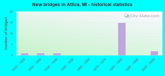
- New bridges - historical statistics
- 11920-1929
- 11930-1939
- 11940-1949
- 151980-1989
- 22000-2009


- Bridge Condition - Deck
- 30.0%Good
- 50.0%Satisfactory
- 20.0%Fair

- Bridge Condition - Superstructure
- 20.0%Very good
- 40.0%Good
- 30.0%Satisfactory
- 10.0%Poor

- Bridge Condition - Substructure
- 10.0%Very good
- 40.0%Good
- 30.0%Satisfactory
- 20.0%Fair

- Bridge Condition - Channel
- 33.3%Good
- 33.3%Satisfactory
- 33.3%Fair

- Bridge Condition - Culverts
- 33.3%Good
- 33.3%Satisfactory
- 33.3%Poor
Find on map >> Show street view
Structure Number: 485, Location: 2.1 MI SE OF BARAGA (Lat: 46.753528, Lng: -88.493783), Route carried "on" structure: US 41, Year Built: 1933, Status: Open, Structure Length: 0.82m (2.69ft), Average Daily Traffic: 5,182 (year 2007), Truck Traffic: 7%, Average Future Daily Traffic: 9,656 (year 2018), Design Load: H 15, Features Intersected: BAYOU & BLK WATER CREEK
Minimum Vertical Clearance: 30.48m (100.00ft), Kilometerpoint: 52.394, Lanes on structure: 2, Base Highway Network: Yes (Inventory Route: 118, Subroute: 7), Owner: State Highway Agency, Approaching Roadway Width: 12.2m (40.0ft), Material/Design: Concrete, Design/Construction: Culvert, Number Of Spans In Main Unit: 2, Length of Maximum Span: 4.2m (13.8ft), Curb or Sidewalk Widths: Left: 0.1m (0.3ft), Right: 0.1m (0.3ft), Curb-To-Curb Width: 11.0m (36.1ft), Out-to-Out Width: 11.7m (38.4ft)
Condition: Channel: Fair, Culverts: Poor, Operating Rating: 40.5 metric tons, Method Used To Determine Operating Rating: Field evaluation and documented engineering judgment, Inventory Rating: 24.3 metric tons, Method Used To Determine Inventory Rating: Field evaluation and documented engineering judgment, Structural Evaluation: Meets minimum limits, Deck Geometry: Meets minimum limits, Waterway Adequacy: Better than present minimum criteria, Approach Roadway Alignment: Equal to present minimum criteria, Designated Inspection Frequency: Every 24 months, Underwater Inspection Frequency: Every 60 months, Inspection Date: July 2021, Underwater Inspection Date: July 2021, Deck Structure Type: Concrete Cast-file-Place, Wearing Surface/Protective System: Wearing Surface: Bituminous
Find on map >> Show street view
Structure Number: 2062, Location: 18.0 MI NE OF GRAYLING (Lat: 44.715650, Lng: -84.408992), Route carried "on" structure: County highway 2054, Year Built: 1948, Status: Posted for load, Structure Length: 1.52m (4.99ft), Average Daily Traffic: 261 (year 2010), Average Future Daily Traffic: 915 (year 2035), Design Load: HS 20+Mod, Features Intersected: BIG CREEK, Facility Carried by Structure: N DOWN RIVER RD
Minimum Vertical Clearance: 30.48m (100.00ft), Kilometerpoint: 8.913, Lanes on structure: 2, Owner: County Highway Agency, Approaching Roadway Width: 10.9m (35.8ft), Skew: 1 degrees, Material/Design: Steel, Design/Construction: Stringer/Multi-beam, Number Of Spans In Main Unit: 1, Length of Maximum Span: 14.6m (47.9ft), Curb or Sidewalk Widths: Left: 0.4m (1.3ft), Right: 0.4m (1.3ft), Curb-To-Curb Width: 7.9m (25.9ft), Out-to-Out Width: 9.5m (31.2ft)
Condition: Deck: Good, Superstructure: Poor, Substructure: Fair, Channel: Good, Operating Rating: 20.1 metric tons, Method Used To Determine Operating Rating: Load and Resistance Factor Rating (LRFR) rating reported by rating factor(RF) method using HL-93 loadings, Inventory Rating: 15.6 metric tons, Method Used To Determine Inventory Rating: Load and Resistance Factor Rating (LRFR) rating reported by rating factor(RF) method using HL-93 loadings, Structural Evaluation: Meets minimum limits, Deck Geometry: Somewhat better than minimum adequacy, Waterway Adequacy: Equal to present desirable criteria, Approach Roadway Alignment: Equal to present desirable criteria, Bridge Posting: Required (Relationship of Operating Rating to Maximum Legal Load: > 39.9% below), Length Of Structure Improvement: 1.52m (4.99ft), Designated Inspection Frequency: Every 12 months, Inspection Date: September 2021, Bridge Improvement Cost: $19,000, Roadway Improvement Cost: $2,000, Total Project Cost: $21,000, Deck Structure Type: Concrete Cast-file-Place, Wearing Surface/Protective System: Wearing Surface: Bituminous
Find on map >> Show street view
Structure Number: 2063, Location: 5.0 MI SW OF FREDERIC (Lat: 44.771222, Lng: -84.841411), Route carried "on" structure: County highway 2082, Year Built: 1920, Year Reconstructed: 1960, Status: Open, Structure Length: 1.89m (6.20ft), Average Daily Traffic: 250 (year 1985), Average Future Daily Traffic: 400 (year 2010), Design Load: HS 20+Mod, Features Intersected: MANISTEE RIVER, Facility Carried by Structure: COUNTY RD 612
Minimum Vertical Clearance: 30.48m (100.00ft), Kilometerpoint: 0.800, Lanes on structure: 2, Owner: County Highway Agency, Approaching Roadway Width: 10.9m (35.8ft), Material/Design: Prestressed concrete, Design/Construction: Box Beam or Girders - Multiple, Number Of Spans In Main Unit: 1, Length of Maximum Span: 18.9m (62.0ft), Curb-To-Curb Width: 8.1m (26.6ft), Out-to-Out Width: 8.2m (26.9ft)
Condition: Deck: Good, Superstructure: Good, Substructure: Fair, Channel: Good, Operating Rating: 81.0 metric tons, Method Used To Determine Operating Rating: Load Factor (LF) rating reported by rating factor (RF) method using MS18 loading, Inventory Rating: 48.6 metric tons, Method Used To Determine Inventory Rating: Load Factor (LF) rating reported by rating factor (RF) method using MS18 loading, Structural Evaluation: Somewhat better than minimum adequacy, Deck Geometry: Somewhat better than minimum adequacy, Waterway Adequacy: Equal to present desirable criteria, Approach Roadway Alignment: Equal to present desirable criteria, Designated Inspection Frequency: Every 24 months, Inspection Date: November 2020, Deck Structure Type: Concrete Precast Panels, Wearing Surface/Protective System: Wearing Surface: Bituminous
Find on map >> Show street view
Structure Number: 2922, Location: 130 RODS S OF ESTEY RD (Lat: 43.864031, Lng: -84.186642), Route carried "on" structure: County highway , Year Built: 2002, Status: Open, Structure Length: 0.79m (2.59ft), Average Daily Traffic: 260 (year 2001), Truck Traffic: 5%, Average Future Daily Traffic: 390 (year 2021), Design Load: HS 20+Mod, Features Intersected: WATSON DRAIN, Facility Carried by Structure: KLENDER RD
Minimum Vertical Clearance: 30.48m (100.00ft), Kilometerpoint: 3.645, Lanes on structure: 2, Owner: County Highway Agency, Approaching Roadway Width: 9.8m (32.2ft), Material/Design: Concrete, Design/Construction: Culvert, Number Of Spans In Main Unit: 1, Length of Maximum Span: 7.0m (23.0ft)
Condition: Channel: Satisfactory, Culverts: Satisfactory, Operating Rating: 32.7 metric tons, Method Used To Determine Operating Rating: Field evaluation and documented engineering judgment, Inventory Rating: 19.6 metric tons, Method Used To Determine Inventory Rating: Field evaluation and documented engineering judgment, Structural Evaluation: Somewhat better than minimum adequacy, Waterway Adequacy: Equal to present desirable criteria, Approach Roadway Alignment: Better than present minimum criteria, Designated Inspection Frequency: Every 24 months, Inspection Date: March 2020, Deck Structure Type: Concrete Precast Panels, Wearing Surface/Protective System: Wearing Surface: Bituminous, Membrane: Preformed Fabric
Find on map >> Show street view
Structure Number: 3906, Location: 1.7 MI SW OF BELL OAK (Lat: 42.707217, Lng: -84.185467), Route carried "on" structure: County highway , Year Built: 1983, Status: Open, Structure Length: 0.85m (2.79ft), Average Daily Traffic: 130 (year 2019), Truck Traffic: 2%, Average Future Daily Traffic: 160 (year 2039), Design Load: H 20, Features Intersected: WOLF CREEK, Facility Carried by Structure: MOYER ROAD
Minimum Vertical Clearance: 30.48m (100.00ft), Kilometerpoint: 7.329, Lanes on structure: 2, Owner: County Highway Agency, Approaching Roadway Width: 9.1m (29.9ft), Material/Design: Prestressed concrete, Design/Construction: Box Beam or Girders - Multiple, Number Of Spans In Main Unit: 1, Length of Maximum Span: 8.5m (27.9ft), Curb-To-Curb Width: 7.3m (24.0ft), Out-to-Out Width: 7.4m (24.3ft)
Condition: Deck: Fair, Superstructure: Satisfactory, Substructure: Satisfactory, Channel: Satisfactory, Operating Rating: 54.1 metric tons, Method Used To Determine Operating Rating: Load Factor (LF) rating reported by rating factor (RF) method using MS18 loading, Inventory Rating: 32.4 metric tons, Method Used To Determine Inventory Rating: Load Factor (LF) rating reported by rating factor (RF) method using MS18 loading, Structural Evaluation: Equal to present minimum criteria, Deck Geometry: Somewhat better than minimum adequacy, Waterway Adequacy: Equal to present minimum criteria, Approach Roadway Alignment: Equal to present desirable criteria, Length Of Structure Improvement: 0.85m (2.79ft), Designated Inspection Frequency: Every 24 months, Inspection Date: June 2021, Bridge Improvement Cost: $36,000, Roadway Improvement Cost: $79,000, Total Project Cost: $115,000, Deck Structure Type: Concrete Precast Panels, Wearing Surface/Protective System: Wearing Surface: Bituminous
Find on map >> Show street view
Structure Number: 5341, Location: 0.2 MI E OF WILDER RD (Lat: 43.011489, Lng: -83.240533), Route carried "on" structure: Ramp Interstate 69, Year Built: 1983, Status: Open, Structure Length: 0.76m (2.49ft), Average Daily Traffic: 7,500 (year 1993), Design Load: HS 20+Mod, Features Intersected: PINE CREEK
Minimum Vertical Clearance: 30.48m (100.00ft), Kilometerpoint: 0.513, Lanes on structure: 1, Owner: State Highway Agency, Approaching Roadway Width: 11.0m (36.1ft), Material/Design: Concrete, Design/Construction: Culvert, Number Of Spans In Main Unit: 2, Length of Maximum Span: 3.8m (12.5ft), Out-to-Out Width: 25.4m (83.3ft)
Condition: Channel: Fair, Culverts: Good, Operating Rating: 59.6 metric tons, Method Used To Determine Operating Rating: Load Factor (LF) rating reported by rating factor (RF) method using MS18 loading, Inventory Rating: 35.6 metric tons, Method Used To Determine Inventory Rating: Load Factor (LF) rating reported by rating factor (RF) method using MS18 loading, Structural Evaluation: Better than present minimum criteria, Waterway Adequacy: Equal to present minimum criteria, Approach Roadway Alignment: Equal to present desirable criteria, Designated Inspection Frequency: Every 24 months, Inspection Date: May 2021, Wearing Surface/Protective System: Deck Protection: Epoxy Coated Reinforcing
Find on map >> Show street view
Structure Number: 5348, Location: 4.0 M E OF LAPEER (Lat: 43.008392, Lng: -83.223550), Route carried "on" structure: County highway 44, Year Built: 1983, Status: Open, Structure Length: 11.82m (38.78ft), Average Daily Traffic: 315 (year 1997), Truck Traffic: 2%, Average Future Daily Traffic: 1,500 (year 2016), Design Load: HS 25 or greater, Features Intersected: I-69, Facility Carried by Structure: 5 LAKES RD
Minimum Vertical Clearance: 30.48m (100.00ft), Kilometerpoint: 3.966, Lanes on structure: 2, Lanes under structure: 5, Owner: State Highway Agency, Approaching Roadway Width: 14.6m (47.9ft), Skew: 1 degrees, Material/Design: Steel continuous, Design/Construction: Stringer/Multi-beam, Number Of Spans In Main Unit: 3, Length of Maximum Span: 43.9m (144.0ft), Curb-To-Curb Width: 12.8m (42.0ft), Out-to-Out Width: 14.0m (45.9ft)
Condition: Deck: Satisfactory, Superstructure: Very good, Substructure: Very good, Operating Rating: 69.7 metric tons, Method Used To Determine Operating Rating: Load Factor (LF) rating reported by rating factor (RF) method using MS18 loading, Inventory Rating: 41.8 metric tons, Method Used To Determine Inventory Rating: Load Factor (LF) rating reported by rating factor (RF) method using MS18 loading, Structural Evaluation: Equal to present desirable criteria, Deck Geometry: Superior to present desirable criteria, Underclear: Somewhat better than minimum adequacy, Approach Roadway Alignment: Equal to present desirable criteria, Designated Inspection Frequency: Every 24 months, Inspection Date: April 2021, Deck Structure Type: Concrete Cast-file-Place, Wearing Surface/Protective System: Wearing Surface: Epoxy Overlay, Deck Protection: Epoxy Coated Reinforcing
Find on map >> Show street view
Structure Number: 5349, Location: 6.0 M E OF LAPEER (Lat: 43.009975, Lng: -83.184667), Route carried "on" structure: County highway 44, Year Built: 1983, Status: Open, Structure Length: 9.27m (30.41ft), Average Daily Traffic: 775 (year 1997), Truck Traffic: 2%, Average Future Daily Traffic: 1,500 (year 2016), Design Load: HS 25 or greater, Features Intersected: I-69, Facility Carried by Structure: LK GEORGE RD
Minimum Vertical Clearance: 30.48m (100.00ft), Kilometerpoint: 4.011, Lanes on structure: 2, Lanes under structure: 4, Owner: State Highway Agency, Approaching Roadway Width: 14.6m (47.9ft), Material/Design: Steel continuous, Design/Construction: Stringer/Multi-beam, Number Of Spans In Main Unit: 2, Length of Maximum Span: 45.7m (149.9ft), Curb-To-Curb Width: 12.8m (42.0ft), Out-to-Out Width: 14.0m (45.9ft)
Condition: Deck: Fair, Superstructure: Good, Substructure: Good, Operating Rating: 72.6 metric tons, Method Used To Determine Operating Rating: Load Factor (LF) rating reported by rating factor (RF) method using MS18 loading, Inventory Rating: 43.4 metric tons, Method Used To Determine Inventory Rating: Load Factor (LF) rating reported by rating factor (RF) method using MS18 loading, Structural Evaluation: Better than present minimum criteria, Deck Geometry: Superior to present desirable criteria, Underclear: Somewhat better than minimum adequacy, Approach Roadway Alignment: Equal to present desirable criteria, Designated Inspection Frequency: Every 24 months, Inspection Date: January 2022, Deck Structure Type: Concrete Cast-file-Place, Wearing Surface/Protective System: Wearing Surface: Epoxy Overlay, Deck Protection: Epoxy Coated Reinforcing
Find on map >> Show street view
Structure Number: 5351, Location: 3.7 M W OF IMLAY CITY (Lat: 43.003933, Lng: -83.150142), Route carried "on" structure: Interstate 69, Year Built: 1983, Status: Open, Structure Length: 3.61m (11.84ft), Average Daily Traffic: 18,845 (year 2012), Truck Traffic: 17%, Average Future Daily Traffic: 12,941 (year 2018), Design Load: HS 25 or greater, Features Intersected: NEWARK RD
Minimum Vertical Clearance: 30.48m (100.00ft), Kilometerpoint: 26.235, Lanes on structure: 2, Lanes under structure: 2, Base Highway Network: Yes (Inventory Route: 75, Subroute: 2), Owner: State Highway Agency, Approaching Roadway Width: 10.7m (35.1ft), Skew: 3 degrees, Material/Design: Steel, Design/Construction: Stringer/Multi-beam, Number Of Spans In Main Unit: 1, Length of Maximum Span: 35.8m (117.5ft), Curb-To-Curb Width: 13.6m (44.6ft), Out-to-Out Width: 14.8m (48.6ft)
Condition: Deck: Satisfactory, Superstructure: Good, Substructure: Satisfactory, Operating Rating: 93.3 metric tons, Method Used To Determine Operating Rating: Load Factor (LF) rating reported by rating factor (RF) method using MS18 loading, Inventory Rating: 55.7 metric tons, Method Used To Determine Inventory Rating: Load Factor (LF) rating reported by rating factor (RF) method using MS18 loading, Structural Evaluation: Equal to present minimum criteria, Deck Geometry: Superior to present desirable criteria, Underclear: Equal to present minimum criteria, Approach Roadway Alignment: Equal to present desirable criteria, Designated Inspection Frequency: Every 24 months, Inspection Date: January 2022, Deck Structure Type: Concrete Cast-file-Place, Wearing Surface/Protective System: Wearing Surface: Epoxy Overlay, Deck Protection: Epoxy Coated Reinforcing
Find on map >> Show street view
Structure Number: 5352, Location: 3 M SW OF IMLAY CITY (Lat: 42.996475, Lng: -83.124886), Route carried "on" structure: Interstate 69, Year Built: 1983, Status: Open, Structure Length: 2.94m (9.65ft), Average Daily Traffic: 18,845 (year 2012), Truck Traffic: 17%, Average Future Daily Traffic: 12,941 (year 2018), Design Load: HS 25 or greater, Features Intersected: WINSLOW RD
Minimum Vertical Clearance: 30.48m (100.00ft), Kilometerpoint: 28.628, Lanes on structure: 2, Lanes under structure: 2, Base Highway Network: Yes (Inventory Route: 75, Subroute: 2), Owner: State Highway Agency, Approaching Roadway Width: 10.7m (35.1ft), Material/Design: Steel, Design/Construction: Stringer/Multi-beam, Number Of Spans In Main Unit: 1, Length of Maximum Span: 29.4m (96.5ft), Curb-To-Curb Width: 13.4m (44.0ft), Out-to-Out Width: 14.6m (47.9ft)
Condition: Deck: Satisfactory, Superstructure: Satisfactory, Substructure: Good, Operating Rating: 85.9 metric tons, Method Used To Determine Operating Rating: Load Factor (LF) rating reported by rating factor (RF) method using MS18 loading, Inventory Rating: 51.2 metric tons, Method Used To Determine Inventory Rating: Load Factor (LF) rating reported by rating factor (RF) method using MS18 loading, Structural Evaluation: Equal to present minimum criteria, Deck Geometry: Superior to present desirable criteria, Underclear: Equal to present minimum criteria, Approach Roadway Alignment: Equal to present desirable criteria, Designated Inspection Frequency: Every 24 months, Inspection Date: April 2021, Deck Structure Type: Concrete Cast-file-Place, Wearing Surface/Protective System: Wearing Surface: Epoxy Overlay, Deck Protection: Epoxy Coated Reinforcing
Find on map >> Show street view
Structure Number: 5353, Location: 3 MI SW OF IMLAY CITY (Lat: 42.996808, Lng: -83.124914), Route carried "on" structure: Interstate 69, Year Built: 1983, Status: Open, Structure Length: 2.94m (9.65ft), Average Daily Traffic: 18,845 (year 2012), Truck Traffic: 17%, Average Future Daily Traffic: 12,941 (year 2018), Design Load: HS 25 or greater, Features Intersected: WINSLOW RD
Minimum Vertical Clearance: 30.48m (100.00ft), Kilometerpoint: 28.583, Lanes on structure: 2, Lanes under structure: 2, Base Highway Network: Yes (Inventory Route: 75, Subroute: 10), Owner: State Highway Agency, Approaching Roadway Width: 10.7m (35.1ft), Material/Design: Steel, Design/Construction: Stringer/Multi-beam, Number Of Spans In Main Unit: 1, Length of Maximum Span: 29.4m (96.5ft), Curb-To-Curb Width: 13.4m (44.0ft), Out-to-Out Width: 14.6m (47.9ft)
Condition: Deck: Satisfactory, Superstructure: Satisfactory, Substructure: Good, Operating Rating: 86.2 metric tons, Method Used To Determine Operating Rating: Load Factor (LF) rating reported by rating factor (RF) method using MS18 loading, Inventory Rating: 51.5 metric tons, Method Used To Determine Inventory Rating: Load Factor (LF) rating reported by rating factor (RF) method using MS18 loading, Structural Evaluation: Equal to present minimum criteria, Deck Geometry: Superior to present desirable criteria, Underclear: Equal to present minimum criteria, Approach Roadway Alignment: Equal to present desirable criteria, Designated Inspection Frequency: Every 24 months, Inspection Date: April 2021, Deck Structure Type: Concrete Cast-file-Place, Wearing Surface/Protective System: Wearing Surface: Epoxy Overlay, Deck Protection: Epoxy Coated Reinforcing
Find on map >> Show street view
Structure Number: 5362, Location: 3.7 M W OF IMLAY CITY (Lat: 43.003956, Lng: -83.149594), Route carried "on" structure: Interstate 69, Year Built: 1983, Status: Open, Structure Length: 3.58m (11.75ft), Average Daily Traffic: 18,845 (year 2012), Truck Traffic: 17%, Average Future Daily Traffic: 12,941 (year 2018), Design Load: HS 25 or greater, Features Intersected: NEWARK RD
Minimum Vertical Clearance: 30.48m (100.00ft), Kilometerpoint: 26.285, Lanes on structure: 2, Lanes under structure: 2, Base Highway Network: Yes (Inventory Route: 75, Subroute: 10), Owner: State Highway Agency, Approaching Roadway Width: 10.7m (35.1ft), Skew: 3 degrees, Material/Design: Steel, Design/Construction: Stringer/Multi-beam, Number Of Spans In Main Unit: 1, Length of Maximum Span: 35.5m (116.5ft), Curb-To-Curb Width: 13.4m (44.0ft), Out-to-Out Width: 14.6m (47.9ft)
Condition: Deck: Satisfactory, Superstructure: Good, Substructure: Good, Operating Rating: 91.0 metric tons, Method Used To Determine Operating Rating: Load Factor (LF) rating reported by rating factor (RF) method using MS18 loading, Inventory Rating: 54.4 metric tons, Method Used To Determine Inventory Rating: Load Factor (LF) rating reported by rating factor (RF) method using MS18 loading, Structural Evaluation: Better than present minimum criteria, Deck Geometry: Superior to present desirable criteria, Underclear: Equal to present minimum criteria, Approach Roadway Alignment: Equal to present desirable criteria, Designated Inspection Frequency: Every 24 months, Inspection Date: January 2022, Deck Structure Type: Concrete Cast-file-Place, Wearing Surface/Protective System: Wearing Surface: Epoxy Overlay, Deck Protection: Epoxy Coated Reinforcing
Find on map >> Show street view
Structure Number: 543, Location: SEC 18 IMLAYTWP (Lat: 43.026450, Lng: -83.107231), Route carried "on" structure: ServiceCounty highway , Year Built: 2004, Status: Open, Structure Length: 3.51m (11.52ft), Average Daily Traffic: 180 (year 2018), Average Future Daily Traffic: 220 (year 2038), Design Load: HS 20, Features Intersected: CN NORTH AMERICA, Facility Carried by Structure: SUMMERS ROAD
Minimum Vertical Clearance: 30.48m (100.00ft), Kilometerpoint: 5.597, Lanes on structure: 2, Owner: County Highway Agency, Approaching Roadway Width: 8.5m (27.9ft), Material/Design: Prestressed concrete, Design/Construction: Box Beam or Girders - Multiple, Number Of Spans In Main Unit: 3, Length of Maximum Span: 15.6m (51.2ft), Curb-To-Curb Width: 8.5m (27.9ft), Out-to-Out Width: 9.7m (31.8ft)
Condition: Deck: Good, Superstructure: Very good, Substructure: Satisfactory, Operating Rating: 82.3 metric tons, Method Used To Determine Operating Rating: Load Factor (LF) rating reported by rating factor (RF) method using MS18 loading, Inventory Rating: 49.2 metric tons, Method Used To Determine Inventory Rating: Load Factor (LF) rating reported by rating factor (RF) method using MS18 loading, Structural Evaluation: Equal to present minimum criteria, Deck Geometry: Equal to present minimum criteria, Approach Roadway Alignment: Better than present minimum criteria, Designated Inspection Frequency: Every 24 months, Inspection Date: July 2021, Deck Structure Type: Concrete Cast-file-Place, Wearing Surface/Protective System: Wearing Surface: Monolithic Concrete, Deck Protection: Epoxy Coated Reinforcing
Find on map >> Show street view
Structure Number: 5348, Location: 4.0 M E OF LAPEER (Lat: 43.008392, Lng: -83.223550), Route carried "under" structure: Interstate 69, Year Built: 1983, Structure Length: 0. m, Average Daily Traffic: 20,565 (year 2013), Truck Traffic: 17%, Features Intersected: I-69, Facility Carried by Structure: 5 LAKES RD
Minimum Vertical Clearance: 5.51m (18.08ft), Kilometerpoint: 20.043, Lanes on structure: 2, Lanes under structure: 5, Material/Design: Steel continuous, Design/Construction: Stringer/Multi-beam, Length of Maximum Span: 43.9m (144.0ft)
Find on map >> Show street view
Structure Number: 5349, Location: 6.0 M E OF LAPEER (Lat: 43.009975, Lng: -83.184667), Route carried "under" structure: Interstate 69, Year Built: 1983, Structure Length: 0. m, Average Daily Traffic: 20,565 (year 2013), Truck Traffic: 17%, Features Intersected: I-69, Facility Carried by Structure: LK GEORGE RD
Minimum Vertical Clearance: 5.05m (16.57ft), Kilometerpoint: 23.259, Lanes on structure: 2, Lanes under structure: 4, Material/Design: Steel continuous, Design/Construction: Stringer/Multi-beam, Length of Maximum Span: 45.7m (149.9ft)
Find on map >> Show street view
Structure Number: 535, Location: 4.5 M W OF IMLAY CITY (Lat: 43.008500, Lng: -83.165075), Route carried "under" structure: Interstate 69, Year Built: 1983, Structure Length: 0. m, Average Daily Traffic: 20,565 (year 2013), Truck Traffic: 17%, Features Intersected: I-69, Facility Carried by Structure: LK PLEASANT RD
Minimum Vertical Clearance: 5.51m (18.08ft), Kilometerpoint: 24.865, Lanes on structure: 2, Lanes under structure: 4, Material/Design: Steel continuous, Design/Construction: Stringer/Multi-beam, Length of Maximum Span: 41.0m (134.5ft)
Find on map >> Show street view
Structure Number: 5351, Location: 3.7 M W OF IMLAY CITY (Lat: 43.003933, Lng: -83.150142), Route carried "under" structure: County highway 44, Year Built: 1983, Structure Length: 0. m, Average Daily Traffic: 2,050 (year 1994), Truck Traffic: 2%, Features Intersected: NEWARK RD, Facility Carried by Structure: I-69 EB
Minimum Vertical Clearance: 4.75m (15.58ft), Kilometerpoint: 13.949, Lanes on structure: 2, Lanes under structure: 2, Material/Design: Steel, Design/Construction: Stringer/Multi-beam, Length of Maximum Span: 35.8m (117.5ft)
Find on map >> Show street view
Structure Number: 5352, Location: 3 M SW OF IMLAY CITY (Lat: 42.996475, Lng: -83.124886), Route carried "under" structure: County highway 44, Year Built: 1983, Structure Length: 0. m, Average Daily Traffic: 255 (year 1997), Truck Traffic: 2%, Features Intersected: WINSLOW RD, Facility Carried by Structure: I-69 EB
Minimum Vertical Clearance: 4.88m (16.01ft), Kilometerpoint: 2.422, Lanes on structure: 2, Lanes under structure: 2, Material/Design: Steel, Design/Construction: Stringer/Multi-beam, Length of Maximum Span: 29.4m (96.5ft)
Find on map >> Show street view
Structure Number: 5353, Location: 3 MI SW OF IMLAY CITY (Lat: 42.996808, Lng: -83.124914), Route carried "under" structure: County highway 44, Year Built: 1983, Structure Length: 0. m, Average Daily Traffic: 255 (year 1997), Truck Traffic: 2%, Features Intersected: WINSLOW RD, Facility Carried by Structure: I-69 WB
Minimum Vertical Clearance: 5.00m (16.40ft), Kilometerpoint: 2.461, Lanes on structure: 2, Lanes under structure: 2, Material/Design: Steel, Design/Construction: Stringer/Multi-beam, Length of Maximum Span: 29.4m (96.5ft)
Find on map >> Show street view
Structure Number: 5362, Location: 3.7 M W OF IMLAY CITY (Lat: 43.003956, Lng: -83.149594), Route carried "under" structure: County highway 44, Year Built: 1983, Structure Length: 0. m, Average Daily Traffic: 2,050 (year 1994), Truck Traffic: 2%, Features Intersected: NEWARK RD, Facility Carried by Structure: I-69 WB
Minimum Vertical Clearance: 4.65m (15.26ft), Kilometerpoint: 13.994, Lanes on structure: 2, Lanes under structure: 2, Material/Design: Steel, Design/Construction: Stringer/Multi-beam, Length of Maximum Span: 35.5m (116.5ft)