Bridge Statistics for Atlanta, Illinois (IL)
Condition, Traffic, Stress, Structural Evaluation, Project Costs
- National Bridge Inventory (NBI) Statistics
- 24Number of bridges
- 315ft / 95.7mTotal length
- $81,000Total costs
- 123,295Total average daily traffic
- 36,299Total average daily truck traffic
- National Bridge Inventory (NBI) Registered Bridges for Atlanta
- No street view available for this location
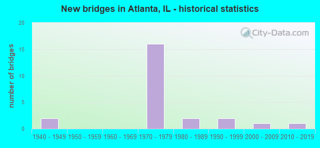
- New bridges - historical statistics
- 21940-1949
- 161970-1979
- 21980-1989
- 21990-1999
- 12000-2009
- 12010-2019

- Reconstructed bridges - Historical Statistics
- 11940-1949
- 01950-1959
- 01960-1969
- 01970-1979
- 01980-1989
- 01990-1999
- 12000-2009
- 32010-2019


- Bridge Condition - Deck
- 5.9%Very good
- 29.4%Good
- 41.2%Satisfactory
- 23.5%Fair

- Bridge Condition - Superstructure
- 5.9%Very good
- 29.4%Good
- 52.9%Satisfactory
- 11.8%Fair

- Bridge Condition - Substructure
- 5.9%Very good
- 29.4%Good
- 23.5%Satisfactory
- 41.2%Fair

- Bridge Condition - Channel
- 12.5%Very good
- 18.8%Good
- 18.8%Satisfactory
- 50.0%Fair

- Bridge Condition - Culverts
- 66.7%Good
- 33.3%Satisfactory
Find on map >> Show street view
Structure Number: 540004, Location: 1.7M N ATLANTA INTCH (Lat: 40.280356, Lng: -89.209194), Route carried "on" structure: County highway , Year Built: 1943, Year Reconstructed: 1954, Status: Open, Structure Length: 0.80m (2.62ft), Average Daily Traffic: 1,000 (year 2020), Truck Traffic: 9%, Average Future Daily Traffic: 1,305 (year 2032), Design Load: HS 20, Features Intersected: CLEAR CREEK, Facility Carried by Structure: I-55 W FRONTAGE RO
Minimum Vertical Clearance: 30+ m (98+ ft), Kilometerpoint: 16.817, Lanes on structure: 2, Owner: State Highway Agency, Approaching Roadway Width: 10.4m (34.1ft), Material/Design: Concrete, Design/Construction: Slab, Number Of Spans In Main Unit: 1, Length of Maximum Span: 7.4m (24.3ft), Curb-To-Curb Width: 13.4m (44.0ft), Out-to-Out Width: 14.4m (47.2ft)
Condition: Deck: Satisfactory, Superstructure: Satisfactory, Substructure: Satisfactory, Channel: Good, Operating Rating: 57.7 metric tons, Method Used To Determine Operating Rating: Load Factor (LF) rating reported by rating factor (RF) method using MS18 loading, Inventory Rating: 34.3 metric tons, Method Used To Determine Inventory Rating: Load Factor (LF) rating reported by rating factor (RF) method using MS18 loading, Structural Evaluation: Equal to present minimum criteria, Deck Geometry: Superior to present desirable criteria, Waterway Adequacy: Superior to present desirable criteria, Approach Roadway Alignment: Equal to present desirable criteria, Designated Inspection Frequency: Every 24 months, Inspection Date: October 2020, Deck Structure Type: Concrete Cast-file-Place, Wearing Surface/Protective System: Wearing Surface: Other
Find on map >> Show street view
Structure Number: 540062, Location: LAWNDALE 3.5 N BUS55 (Lat: 40.220878, Lng: -89.279347), Route carried "on" structure: County highway , Year Built: 1974, Status: Open, Structure Length: 15.29m (50.16ft), Average Daily Traffic: 400 (year 2016), Truck Traffic: 23%, Average Future Daily Traffic: 100 (year 2032), Design Load: HS 15, Features Intersected: I-55/UP RR/W FR RD, Facility Carried by Structure: TR 65A
Minimum Vertical Clearance: 30+ m (98+ ft), Kilometerpoint: 0.402, Lanes on structure: 2, Lanes under structure: 6, Owner: State Highway Agency, Approaching Roadway Width: 9.1m (29.9ft), Material/Design: Steel continuous, Design/Construction: Stringer/Multi-beam, Number Of Spans In Main Unit: 4, Number Of Approach Spans: 2, Length of Maximum Span: 33.2m (108.9ft), Curb-To-Curb Width: 8.7m (28.5ft), Out-to-Out Width: 9.8m (32.2ft)
Condition: Deck: Good, Superstructure: Good, Substructure: Good, Operating Rating: 65.8 metric tons, Method Used To Determine Operating Rating: Load Factor (LF) rating reported by rating factor (RF) method using MS18 loading, Inventory Rating: 39.5 metric tons, Method Used To Determine Inventory Rating: Load Factor (LF) rating reported by rating factor (RF) method using MS18 loading, Structural Evaluation: Better than present minimum criteria, Deck Geometry: Equal to present minimum criteria, Underclear: Equal to present minimum criteria, Approach Roadway Alignment: Somewhat better than minimum adequacy, Designated Inspection Frequency: Every 24 months, Inspection Date: December 2021, Deck Structure Type: Concrete Cast-file-Place
Find on map >> Show street view
Structure Number: 540063, Location: 3.6 N BUS55 LAWNDALE (Lat: 40.221592, Lng: -89.276542), Route carried "on" structure: Interstate 55, Year Built: 1974, Year Reconstructed: 2015, Status: Open, Structure Length: 9.65m (31.66ft), Average Daily Traffic: 11,900 (year 2021), Truck Traffic: 30%, Average Future Daily Traffic: 9,789 (year 2032), Design Load: HS 20+Mod, Features Intersected: KICKAPOO CREEK
Minimum Vertical Clearance: 30+ m (98+ ft), Kilometerpoint: 218.221, Lanes on structure: 2, Base Highway Network: Yes, Owner: State Highway Agency, Approaching Roadway Width: 12.5m (41.0ft), Skew: 2 degrees, Material/Design: Steel continuous, Design/Construction: Stringer/Multi-beam, Number Of Spans In Main Unit: 3, Length of Maximum Span: 36.9m (121.1ft), Curb-To-Curb Width: 12.2m (40.0ft), Out-to-Out Width: 13.2m (43.3ft)
Condition: Deck: Fair, Superstructure: Satisfactory, Substructure: Good, Channel: Good, Operating Rating: 75.5 metric tons, Method Used To Determine Operating Rating: Load Factor (LF) rating reported by rating factor (RF) method using MS18 loading, Inventory Rating: 45.0 metric tons, Method Used To Determine Inventory Rating: Load Factor (LF) rating reported by rating factor (RF) method using MS18 loading, Structural Evaluation: Equal to present minimum criteria, Deck Geometry: Better than present minimum criteria, Waterway Adequacy: Superior to present desirable criteria, Approach Roadway Alignment: Equal to present desirable criteria, Designated Inspection Frequency: Every 24 months, Inspection Date: December 2021, Deck Structure Type: Concrete Cast-file-Place, Wearing Surface/Protective System: Deck Protection: Epoxy Coated Reinforcing
Find on map >> Show street view
Structure Number: 540064, Location: 3.6 N BUS55 LAWNDALE (Lat: 40.221775, Lng: -89.276328), Route carried "on" structure: Interstate 55, Year Built: 1974, Year Reconstructed: 2015, Status: Open, Structure Length: 9.65m (31.66ft), Average Daily Traffic: 11,900 (year 2021), Truck Traffic: 30%, Average Future Daily Traffic: 9,789 (year 2032), Design Load: HS 20+Mod, Features Intersected: KICKAPOO CREEK
Minimum Vertical Clearance: 30+ m (98+ ft), Kilometerpoint: 218.237, Lanes on structure: 2, Base Highway Network: Yes, Owner: State Highway Agency, Approaching Roadway Width: 12.5m (41.0ft), Skew: 2 degrees, Material/Design: Steel continuous, Design/Construction: Stringer/Multi-beam, Number Of Spans In Main Unit: 3, Length of Maximum Span: 36.9m (121.1ft), Curb-To-Curb Width: 12.2m (40.0ft), Out-to-Out Width: 13.2m (43.3ft)
Condition: Deck: Fair, Superstructure: Satisfactory, Substructure: Good, Channel: Very good, Operating Rating: 75.5 metric tons, Method Used To Determine Operating Rating: Load Factor (LF) rating reported by rating factor (RF) method using MS18 loading, Inventory Rating: 45.0 metric tons, Method Used To Determine Inventory Rating: Load Factor (LF) rating reported by rating factor (RF) method using MS18 loading, Structural Evaluation: Equal to present minimum criteria, Deck Geometry: Better than present minimum criteria, Waterway Adequacy: Superior to present desirable criteria, Approach Roadway Alignment: Equal to present desirable criteria, Designated Inspection Frequency: Every 24 months, Inspection Date: December 2021, Deck Structure Type: Concrete Cast-file-Place, Wearing Surface/Protective System: Deck Protection: Epoxy Coated Reinforcing
Find on map >> Show street view
Structure Number: 540065, Location: .8M SW ATLANTA INTCH (Lat: 40.252244, Lng: -89.230483), Route carried "on" structure: Interstate 55, Year Built: 1976, Year Reconstructed: 2015, Status: Open, Structure Length: 3.70m (12.14ft), Average Daily Traffic: 11,900 (year 2021), Truck Traffic: 30%, Average Future Daily Traffic: 9,789 (year 2032), Design Load: HS 20, Features Intersected: RACE STREET
Minimum Vertical Clearance: 30+ m (98+ ft), Kilometerpoint: 223.548, Lanes on structure: 2, Lanes under structure: 2, Base Highway Network: Yes, Owner: State Highway Agency, Approaching Roadway Width: 12.2m (40.0ft), Material/Design: Steel continuous, Design/Construction: Stringer/Multi-beam, Number Of Spans In Main Unit: 3, Length of Maximum Span: 14.6m (47.9ft), Curb-To-Curb Width: 12.3m (40.4ft), Out-to-Out Width: 13.3m (43.6ft)
Condition: Deck: Good, Superstructure: Good, Substructure: Good, Operating Rating: 94.6 metric tons, Method Used To Determine Operating Rating: Load Factor (LF) rating reported by rating factor (RF) method using MS18 loading, Inventory Rating: 51.2 metric tons, Method Used To Determine Inventory Rating: Load Factor (LF) rating reported by rating factor (RF) method using MS18 loading, Structural Evaluation: Better than present minimum criteria, Deck Geometry: Better than present minimum criteria, Underclear: Equal to present desirable criteria, Approach Roadway Alignment: Equal to present desirable criteria, Designated Inspection Frequency: Every 24 months, Inspection Date: Febuary 2022, Deck Structure Type: Concrete Cast-file-Place, Wearing Surface/Protective System: Deck Protection: Epoxy Coated Reinforcing
Find on map >> Show street view
Structure Number: 540066, Location: .8M SW ATLANTA INTCH (Lat: 40.252283, Lng: -89.230328), Route carried "on" structure: Interstate 55, Year Built: 1976, Year Reconstructed: 2014, Status: Open, Structure Length: 3.61m (11.84ft), Average Daily Traffic: 11,900 (year 2021), Truck Traffic: 30%, Average Future Daily Traffic: 9,789 (year 2032), Design Load: HS 20, Features Intersected: RACE STREET
Minimum Vertical Clearance: 30+ m (98+ ft), Kilometerpoint: 223.564, Lanes on structure: 2, Lanes under structure: 2, Base Highway Network: Yes, Owner: State Highway Agency, Approaching Roadway Width: 12.2m (40.0ft), Material/Design: Steel continuous, Design/Construction: Stringer/Multi-beam, Number Of Spans In Main Unit: 3, Length of Maximum Span: 14.6m (47.9ft), Curb-To-Curb Width: 12.4m (40.7ft), Out-to-Out Width: 13.4m (44.0ft)
Condition: Deck: Satisfactory, Superstructure: Satisfactory, Substructure: Good, Operating Rating: 92.0 metric tons, Method Used To Determine Operating Rating: Load Factor (LF) rating reported by rating factor (RF) method using MS18 loading, Inventory Rating: 49.6 metric tons, Method Used To Determine Inventory Rating: Load Factor (LF) rating reported by rating factor (RF) method using MS18 loading, Structural Evaluation: Equal to present minimum criteria, Deck Geometry: Better than present minimum criteria, Underclear: Equal to present desirable criteria, Approach Roadway Alignment: Equal to present desirable criteria, Designated Inspection Frequency: Every 24 months, Inspection Date: Febuary 2022, Deck Structure Type: Concrete Cast-file-Place, Wearing Surface/Protective System: Deck Protection: Epoxy Coated Reinforcing
Find on map >> Show street view
Structure Number: 540069, Location: ATLANTA INTERCHANGE (Lat: 40.259614, Lng: -89.220342), Route carried "on" structure: County highway , Year Built: 1976, Status: Open, Structure Length: 10.17m (33.37ft), Average Daily Traffic: 2,750 (year 2016), Truck Traffic: 13%, Average Future Daily Traffic: 2,410 (year 2032), Design Load: HS 20, Features Intersected: I- 55, Facility Carried by Structure: CH 6 (FAS 557)
Minimum Vertical Clearance: 30+ m (98+ ft), Kilometerpoint: 9.028, Lanes on structure: 2, Lanes under structure: 4, Owner: State Highway Agency, Approaching Roadway Width: 10.4m (34.1ft), Skew: 34 degrees, Material/Design: Steel continuous, Design/Construction: Stringer/Multi-beam, Number Of Spans In Main Unit: 2, Number Of Approach Spans: 2, Length of Maximum Span: 39.4m (129.3ft), Curb-To-Curb Width: 14.5m (47.6ft), Out-to-Out Width: 20.7m (67.9ft)
Condition: Deck: Satisfactory, Superstructure: Satisfactory, Substructure: Satisfactory, Operating Rating: 83.3 metric tons, Method Used To Determine Operating Rating: Load Factor (LF) rating reported by rating factor (RF) method using MS18 loading, Inventory Rating: 44.1 metric tons, Method Used To Determine Inventory Rating: Load Factor (LF) rating reported by rating factor (RF) method using MS18 loading, Structural Evaluation: Equal to present minimum criteria, Deck Geometry: Superior to present desirable criteria, Underclear: Somewhat better than minimum adequacy, Approach Roadway Alignment: Equal to present desirable criteria, Designated Inspection Frequency: Every 24 months, Inspection Date: January 2021, Deck Structure Type: Concrete Cast-file-Place, Wearing Surface/Protective System: Wearing Surface: Latex Concrete
Find on map >> Show street view
Structure Number: 540516, Location: .3 M NE LAWNDALE (Lat: 40.221797, Lng: -89.277269), Route carried "on" structure: County highway , Year Built: 2018, Status: Open, Structure Length: 9.66m (31.69ft), Average Daily Traffic: 3,250 (year 2019), Truck Traffic: 11%, Average Future Daily Traffic: 3,300 (year 2042), Design Load: HS 25 or greater, Features Intersected: KICKAPOO CREEK, Facility Carried by Structure: I-55 FRNT ROAD WES
Minimum Vertical Clearance: 30+ m (98+ ft), Kilometerpoint: 7.918, Lanes on structure: 2, Owner: State Highway Agency, Approaching Roadway Width: 9.8m (32.2ft), Skew: 2 degrees, Material/Design: Steel continuous, Design/Construction: Stringer/Multi-beam, Number Of Spans In Main Unit: 3, Length of Maximum Span: 35.7m (117.1ft), Curb-To-Curb Width: 9.8m (32.2ft), Out-to-Out Width: 10.7m (35.1ft)
Condition: Deck: Very good, Superstructure: Very good, Substructure: Very good, Channel: Very good, Operating Rating: 45.0 metric tons, Method Used To Determine Operating Rating: Load and Resistance Factor Rating (LRFR) rating reported by rating factor(RF) method using HL-93 loadings, Inventory Rating: 34.7 metric tons, Method Used To Determine Inventory Rating: Load and Resistance Factor Rating (LRFR) rating reported by rating factor(RF) method using HL-93 loadings, Structural Evaluation: Equal to present desirable criteria, Deck Geometry: Meets minimum limits, Waterway Adequacy: Superior to present desirable criteria, Approach Roadway Alignment: Equal to present desirable criteria, Designated Inspection Frequency: Every 24 months, Inspection Date: September 2020, Deck Structure Type: Concrete Cast-file-Place, Wearing Surface/Protective System: Deck Protection: Epoxy Coated Reinforcing
Find on map >> Show street view
Structure Number: 542019, Location: 1.5M N ATLANTA INT (Lat: 40.280014, Lng: -89.208647), Route carried "on" structure: Interstate 55, Year Built: 1976, Status: Open, Structure Length: 0.77m (2.53ft), Average Daily Traffic: 20,500 (year 2021), Truck Traffic: 33%, Average Future Daily Traffic: 20,482 (year 2032), Design Load: HS 20, Features Intersected: CLEAR CREEK
Minimum Vertical Clearance: 30+ m (98+ ft), Kilometerpoint: 227.314, Lanes on structure: 4, Base Highway Network: Yes, Owner: State Highway Agency, Approaching Roadway Width: 24.4m (80.1ft), Material/Design: Concrete continuous, Design/Construction: Culvert, Number Of Spans In Main Unit: 2, Length of Maximum Span: 3.4m (11.2ft)
Condition: Channel: Good, Culverts: Good, Operating Rating: 97.2 metric tons, Method Used To Determine Operating Rating: Load Factor (LF) rating reported by rating factor (RF) method using MS18 loading, Inventory Rating: 79.7 metric tons, Method Used To Determine Inventory Rating: Load Factor (LF) rating reported by rating factor (RF) method using MS18 loading, Structural Evaluation: Better than present minimum criteria, Waterway Adequacy: Superior to present desirable criteria, Approach Roadway Alignment: Equal to present desirable criteria, Designated Inspection Frequency: Every 24 months, Inspection Date: August 2020
Find on map >> Show street view
Structure Number: 543006, Location: 4 MI S ATLANTA (Lat: 40.213950, Lng: -89.195786), Route carried "on" structure: County highway , Year Built: 1948, Status: Open, Structure Length: 9.69m (31.79ft), Average Daily Traffic: 350 (year 2016), Truck Traffic: 13%, Average Future Daily Traffic: 402 (year 2032), Design Load: H 15, Features Intersected: KICKAPOO CK, Facility Carried by Structure: ATANTA-BEASON RD
Minimum Vertical Clearance: 30+ m (98+ ft), Kilometerpoint: 15.642, Lanes on structure: 2, Owner: County Highway Agency, Approaching Roadway Width: 5.6m (18.4ft), Material/Design: Concrete continuous, Design/Construction: Tee Beam, Number Of Spans In Main Unit: 5, Length of Maximum Span: 24.4m (80.1ft), Curb-To-Curb Width: 7.3m (24.0ft), Out-to-Out Width: 8.0m (26.2ft)
Condition: Deck: Satisfactory, Superstructure: Satisfactory, Substructure: Fair, Channel: Fair, Operating Rating: 35.3 metric tons, Method Used To Determine Operating Rating: Load Factor (LF) rating reported by rating factor (RF) method using MS18 loading, Inventory Rating: 21.1 metric tons, Method Used To Determine Inventory Rating: Load Factor (LF) rating reported by rating factor (RF) method using MS18 loading, Structural Evaluation: Somewhat better than minimum adequacy, Deck Geometry: Somewhat better than minimum adequacy, Waterway Adequacy: Equal to present minimum criteria, Approach Roadway Alignment: Equal to present desirable criteria, Designated Inspection Frequency: Every 24 months, Inspection Date: January 2020, Deck Structure Type: Concrete Cast-file-Place, Wearing Surface/Protective System: Wearing Surface: Gravel, Membrane: Built-up
Find on map >> Show street view
Structure Number: 54392, Location: 3.5 MI SE ATLANTA (Lat: 40.241031, Lng: -89.180622), Route carried "on" structure: County highway , Year Built: 1997, Status: Open, Structure Length: 0.70m (2.30ft), Average Daily Traffic: 600 (year 2016), Truck Traffic: 8%, Average Future Daily Traffic: 351 (year 2032), Design Load: HS 20, Features Intersected: LOCAL DRAINAGE, Facility Carried by Structure: WAYNESVILLE RD
Minimum Vertical Clearance: 30+ m (98+ ft), Kilometerpoint: 2.140, Lanes on structure: 2, Owner: County Highway Agency, Approaching Roadway Width: 6.8m (22.3ft), Skew: 6 degrees, Material/Design: Concrete continuous, Design/Construction: Culvert, Number Of Spans In Main Unit: 2, Length of Maximum Span: 6.6m (21.7ft), Curb-To-Curb Width: 9.2m (30.2ft), Out-to-Out Width: 9.8m (32.2ft)
Condition: Channel: Satisfactory, Culverts: Good, Operating Rating: 48.0 metric tons, Method Used To Determine Operating Rating: Load Factor (LF) rating reported by rating factor (RF) method using MS18 loading, Inventory Rating: 28.5 metric tons, Method Used To Determine Inventory Rating: Load Factor (LF) rating reported by rating factor (RF) method using MS18 loading, Structural Evaluation: Better than present minimum criteria, Deck Geometry: Equal to present minimum criteria, Waterway Adequacy: Better than present minimum criteria, Approach Roadway Alignment: Equal to present desirable criteria, Designated Inspection Frequency: Every 48 months, Inspection Date: December 2021
Find on map >> Show street view
Structure Number: 544101, Location: 2 MI S ATLANTA (Lat: 40.231275, Lng: -89.228275), Route carried "on" structure: County highway , Year Built: 1971, Status: Open, Structure Length: 0.85m (2.79ft), Average Daily Traffic: 200 (year 2016), Truck Traffic: 16%, Average Future Daily Traffic: 151 (year 2032), Design Load: HS 15, Features Intersected: KICKAPOO CK TRIB, Facility Carried by Structure: TR 290
Minimum Vertical Clearance: 30+ m (98+ ft), Kilometerpoint: 2.317, Lanes on structure: 2, Owner: Town or Township Highway Agency, Approaching Roadway Width: 4.8m (15.7ft), Skew: 3 degrees, Material/Design: Concrete, Design/Construction: Channel Beam, Number Of Spans In Main Unit: 1, Length of Maximum Span: 7.9m (25.9ft), Curb-To-Curb Width: 7.9m (25.9ft), Out-to-Out Width: 8.0m (26.2ft)
Condition: Deck: Satisfactory, Superstructure: Satisfactory, Substructure: Fair, Channel: Satisfactory, Operating Rating: 66.7 metric tons, Method Used To Determine Operating Rating: Load Factor (LF) rating reported by rating factor (RF) method using MS18 loading, Inventory Rating: 40.2 metric tons, Method Used To Determine Inventory Rating: Load Factor (LF) rating reported by rating factor (RF) method using MS18 loading, Structural Evaluation: Somewhat better than minimum adequacy, Deck Geometry: Somewhat better than minimum adequacy, Waterway Adequacy: Equal to present minimum criteria, Approach Roadway Alignment: Equal to present desirable criteria, Designated Inspection Frequency: Every 24 months, Inspection Date: December 2020, Deck Structure Type: Concrete Cast-file-Place, Wearing Surface/Protective System: Wearing Surface: Gravel
Find on map >> Show street view
Structure Number: 544105, Location: 2.5 MI E ATLANTA (Lat: 40.258172, Lng: -89.181064), Route carried "on" structure: County highway , Year Built: 1972, Status: Open, Structure Length: 2.04m (6.69ft), Average Daily Traffic: 125 (year 2011), Truck Traffic: 32%, Average Future Daily Traffic: 126 (year 2032), Design Load: HS 15, Features Intersected: CLEAR CK, Facility Carried by Structure: TR 39
Minimum Vertical Clearance: 30+ m (98+ ft), Kilometerpoint: 2.076, Lanes on structure: 2, Owner: Town or Township Highway Agency, Approaching Roadway Width: 4.1m (13.5ft), Material/Design: Prestressed concrete, Design/Construction: Box Beam or Girders - Multiple, Number Of Spans In Main Unit: 1, Length of Maximum Span: 18.9m (62.0ft), Curb-To-Curb Width: 7.3m (24.0ft), Out-to-Out Width: 7.3m (24.0ft)
Condition: Deck: Fair, Superstructure: Fair, Substructure: Fair, Channel: Fair, Operating Rating: 52.5 metric tons, Method Used To Determine Operating Rating: Load Factor (LF) rating reported by rating factor (RF) method using MS18 loading, Inventory Rating: 31.4 metric tons, Method Used To Determine Inventory Rating: Load Factor (LF) rating reported by rating factor (RF) method using MS18 loading, Structural Evaluation: Somewhat better than minimum adequacy, Deck Geometry: Somewhat better than minimum adequacy, Waterway Adequacy: Equal to present minimum criteria, Approach Roadway Alignment: Equal to present minimum criteria, Designated Inspection Frequency: Every 24 months, Inspection Date: December 2020, Deck Structure Type: Concrete Precast Panels, Wearing Surface/Protective System: Wearing Surface: Gravel
Find on map >> Show street view
Structure Number: 544112, Location: 2.0 M E ATLANTA (Lat: 40.267233, Lng: -89.188636), Route carried "on" structure: County highway , Year Built: 1974, Status: Open, Structure Length: 1.71m (5.61ft), Average Daily Traffic: 100 (year 2016), Truck Traffic: 29%, Average Future Daily Traffic: 75 (year 2032), Design Load: HS 15, Features Intersected: CLEAR CK, Facility Carried by Structure: TR 31
Minimum Vertical Clearance: 30+ m (98+ ft), Kilometerpoint: 1.979, Lanes on structure: 2, Owner: Town or Township Highway Agency, Approaching Roadway Width: 4.7m (15.4ft), Material/Design: Prestressed concrete, Design/Construction: Box Beam or Girders - Multiple, Number Of Spans In Main Unit: 1, Length of Maximum Span: 16.2m (53.1ft), Curb-To-Curb Width: 7.3m (24.0ft), Out-to-Out Width: 7.4m (24.3ft)
Condition: Deck: Fair, Superstructure: Fair, Substructure: Satisfactory, Channel: Fair, Operating Rating: 50.5 metric tons, Method Used To Determine Operating Rating: Load Factor (LF) rating reported by rating factor (RF) method using MS18 loading, Inventory Rating: 30.5 metric tons, Method Used To Determine Inventory Rating: Load Factor (LF) rating reported by rating factor (RF) method using MS18 loading, Structural Evaluation: Somewhat better than minimum adequacy, Deck Geometry: Equal to present minimum criteria, Waterway Adequacy: Equal to present minimum criteria, Approach Roadway Alignment: Equal to present minimum criteria, Designated Inspection Frequency: Every 24 months, Inspection Date: December 2020, Deck Structure Type: Concrete Precast Panels, Wearing Surface/Protective System: Wearing Surface: Gravel
Find on map >> Show street view
Structure Number: 544113, Location: 2.75 MI E OF ATLANTA (Lat: 40.267364, Lng: -89.173022), Route carried "on" structure: County highway , Year Built: 1978, Status: Open, Structure Length: 1.43m (4.69ft), Average Daily Traffic: 50 (year 2016), Truck Traffic: 2%, Average Future Daily Traffic: 50 (year 2032), Design Load: HS 20, Features Intersected: LOCAL DRAINAGE, Facility Carried by Structure: TR 31
Minimum Vertical Clearance: 30+ m (98+ ft), Kilometerpoint: 3.315, Lanes on structure: 2, Owner: Town or Township Highway Agency, Approaching Roadway Width: 4.7m (15.4ft), Skew: 2 degrees, Material/Design: Prestressed concrete, Design/Construction: Box Beam or Girders - Multiple, Number Of Spans In Main Unit: 1, Length of Maximum Span: 13.4m (44.0ft), Curb-To-Curb Width: 7.4m (24.3ft), Out-to-Out Width: 7.4m (24.3ft)
Condition: Deck: Good, Superstructure: Good, Substructure: Fair, Channel: Fair, Operating Rating: 44.4 metric tons, Method Used To Determine Operating Rating: Assigned rating based on Load Factor Design (LFD) reported by rating factor (RF) using MS18 loading, Inventory Rating: 32.4 metric tons, Method Used To Determine Inventory Rating: Assigned rating based on Load Factor Design (LFD) reported by rating factor (RF) using MS18 loading, Structural Evaluation: Somewhat better than minimum adequacy, Deck Geometry: Equal to present minimum criteria, Waterway Adequacy: Equal to present minimum criteria, Approach Roadway Alignment: Equal to present desirable criteria, Length Of Structure Improvement: 1.40m (4.59ft), Designated Inspection Frequency: Every 24 months, Inspection Date: December 2020, Bridge Improvement Cost: $54,000, Roadway Improvement Cost: $5,000, Total Project Cost: $81,000, Deck Structure Type: Concrete Precast Panels, Wearing Surface/Protective System: Wearing Surface: Gravel
Find on map >> Show street view
Structure Number: 544115, Location: 2.5 MI E ATLANTA (Lat: 40.266467, Lng: -89.186525), Route carried "on" structure: County highway , Year Built: 1999, Status: Open, Structure Length: 1.71m (5.61ft), Average Daily Traffic: 20 (year 2016), Truck Traffic: 10%, Average Future Daily Traffic: 50 (year 2032), Design Load: HS 20, Features Intersected: CLEAR CREEK, Facility Carried by Structure: TR 314
Minimum Vertical Clearance: 30+ m (98+ ft), Kilometerpoint: 1.690, Lanes on structure: 2, Owner: Town or Township Highway Agency, Approaching Roadway Width: 4.9m (16.1ft), Skew: 2 degrees, Material/Design: Prestressed concrete, Design/Construction: Box Beam or Girders - Multiple, Number Of Spans In Main Unit: 1, Length of Maximum Span: 16.1m (52.8ft), Curb-To-Curb Width: 7.3m (24.0ft), Out-to-Out Width: 7.3m (24.0ft)
Condition: Deck: Good, Superstructure: Good, Substructure: Fair, Channel: Fair, Operating Rating: 44.1 metric tons, Method Used To Determine Operating Rating: Assigned rating based on Load Factor Design (LFD) reported by rating factor (RF) using MS18 loading, Inventory Rating: 32.4 metric tons, Method Used To Determine Inventory Rating: Assigned rating based on Load Factor Design (LFD) reported by rating factor (RF) using MS18 loading, Structural Evaluation: Somewhat better than minimum adequacy, Deck Geometry: Equal to present minimum criteria, Waterway Adequacy: Somewhat better than minimum adequacy, Approach Roadway Alignment: Equal to present desirable criteria, Designated Inspection Frequency: Every 24 months, Inspection Date: December 2020, Deck Structure Type: Concrete Precast Panels
Find on map >> Show street view
Structure Number: 544151, Location: 2 MI S ATLANTA (Lat: 40.227842, Lng: -89.226869), Route carried "on" structure: County highway , Year Built: 2004, Status: Open, Structure Length: 0.63m (2.07ft), Average Daily Traffic: 200 (year 2016), Truck Traffic: 16%, Average Future Daily Traffic: 151 (year 2032), Design Load: HS 20, Features Intersected: KICKAPOO CK TRIB, Facility Carried by Structure: TR 290
Minimum Vertical Clearance: 30+ m (98+ ft), Kilometerpoint: 2.800, Lanes on structure: 2, Owner: Town or Township Highway Agency, Approaching Roadway Width: 4.9m (16.1ft), Material/Design: Aluminum, Iron, Design/Construction: Culvert, Number Of Spans In Main Unit: 1, Length of Maximum Span: 6.3m (20.7ft), Curb-To-Curb Width: 9.3m (30.5ft), Out-to-Out Width: 9.3m (30.5ft)
Condition: Channel: Fair, Culverts: Satisfactory, Operating Rating: 97.2 metric tons, Method Used To Determine Operating Rating: Load Factor (LF) rating reported by rating factor (RF) method using MS18 loading, Inventory Rating: 97.2 metric tons, Method Used To Determine Inventory Rating: Load Factor (LF) rating reported by rating factor (RF) method using MS18 loading, Structural Evaluation: Equal to present minimum criteria, Deck Geometry: Equal to present minimum criteria, Waterway Adequacy: Better than present minimum criteria, Approach Roadway Alignment: Equal to present minimum criteria, Designated Inspection Frequency: Every 24 months, Inspection Date: December 2020
Find on map >> Show street view
Structure Number: 544509, Location: 1 MI E LAWNDALE (Lat: 40.218544, Lng: -89.264083), Route carried "on" structure: County highway , Year Built: 1984, Status: Open, Structure Length: 4.57m (14.99ft), Average Daily Traffic: 50 (year 2016), Truck Traffic: 28%, Average Future Daily Traffic: 50 (year 2032), Design Load: HS 20+Mod, Features Intersected: KICKAPOO CK, Facility Carried by Structure: TR 55
Minimum Vertical Clearance: 30+ m (98+ ft), Kilometerpoint: 4.506, Lanes on structure: 2, Owner: Town or Township Highway Agency, Approaching Roadway Width: 4.2m (13.8ft), Material/Design: Prestressed concrete, Design/Construction: Box Beam or Girders - Multiple, Number Of Spans In Main Unit: 3, Length of Maximum Span: 15.2m (49.9ft), Curb-To-Curb Width: 7.3m (24.0ft), Out-to-Out Width: 7.3m (24.0ft)
Condition: Deck: Satisfactory, Superstructure: Satisfactory, Substructure: Fair, Channel: Fair, Operating Rating: 44.4 metric tons, Method Used To Determine Operating Rating: Assigned rating based on Load Factor Design (LFD) reported by rating factor (RF) using MS18 loading, Inventory Rating: 32.4 metric tons, Method Used To Determine Inventory Rating: Assigned rating based on Load Factor Design (LFD) reported by rating factor (RF) using MS18 loading, Structural Evaluation: Somewhat better than minimum adequacy, Deck Geometry: Equal to present minimum criteria, Waterway Adequacy: Equal to present minimum criteria, Approach Roadway Alignment: Equal to present minimum criteria, Designated Inspection Frequency: Every 24 months, Inspection Date: December 2021, Deck Structure Type: Concrete Precast Panels, Wearing Surface/Protective System: Wearing Surface: Gravel
Find on map >> Show street view
Structure Number: 545205, Location: 2.5 MI S ATLANTA (Lat: 40.214619, Lng: -89.218133), Route carried "on" structure: County highway , Year Built: 1980, Status: Open, Structure Length: 4.60m (15.09ft), Average Daily Traffic: 200 (year 2016), Truck Traffic: 16%, Average Future Daily Traffic: 151 (year 2032), Features Intersected: KICKAPOO CRK, Facility Carried by Structure: TR 290
Minimum Vertical Clearance: 30+ m (98+ ft), Kilometerpoint: 4.587, Lanes on structure: 2, Owner: Town or Township Highway Agency, Approaching Roadway Width: 5.2m (17.1ft), Material/Design: Prestressed concrete, Design/Construction: Box Beam or Girders - Multiple, Number Of Spans In Main Unit: 3, Length of Maximum Span: 15.2m (49.9ft), Curb-To-Curb Width: 7.4m (24.3ft), Out-to-Out Width: 7.4m (24.3ft)
Condition: Deck: Satisfactory, Superstructure: Satisfactory, Substructure: Satisfactory, Channel: Fair, Operating Rating: 61.6 metric tons, Method Used To Determine Operating Rating: Load Factor (LF) rating reported by rating factor (RF) method using MS18 loading, Inventory Rating: 36.9 metric tons, Method Used To Determine Inventory Rating: Load Factor (LF) rating reported by rating factor (RF) method using MS18 loading, Structural Evaluation: Equal to present minimum criteria, Deck Geometry: Somewhat better than minimum adequacy, Waterway Adequacy: Equal to present minimum criteria, Approach Roadway Alignment: Equal to present desirable criteria, Designated Inspection Frequency: Every 24 months, Inspection Date: January 2020, Deck Structure Type: Concrete Precast Panels
Find on map >> Show street view
Structure Number: 575213, Location: 3.5 MI W MCLEAN (Lat: 40.321794, Lng: -89.234483), Route carried "on" structure: County highway , Year Built: 1975, Status: Open, Structure Length: 4.42m (14.50ft), Average Daily Traffic: 150 (year 2020), Truck Traffic: 3%, Average Future Daily Traffic: 279 (year 2032), Design Load: HS 15, Features Intersected: SUGAR CREEK, Facility Carried by Structure: TR 16
Minimum Vertical Clearance: 30+ m (98+ ft), Kilometerpoint: 2.044, Lanes on structure: 2, Owner: Town or Township Highway Agency, Approaching Roadway Width: 4.9m (16.1ft), Skew: 1 degrees, Material/Design: Concrete continuous, Design/Construction: Slab, Number Of Spans In Main Unit: 4, Length of Maximum Span: 12.2m (40.0ft), Curb-To-Curb Width: 7.3m (24.0ft), Out-to-Out Width: 7.9m (25.9ft)
Condition: Deck: Good, Superstructure: Good, Substructure: Fair, Channel: Satisfactory, Operating Rating: 52.5 metric tons, Method Used To Determine Operating Rating: Load Factor (LF) rating reported by rating factor (RF) method using MS18 loading, Inventory Rating: 31.4 metric tons, Method Used To Determine Inventory Rating: Load Factor (LF) rating reported by rating factor (RF) method using MS18 loading, Structural Evaluation: Somewhat better than minimum adequacy, Deck Geometry: Somewhat better than minimum adequacy, Waterway Adequacy: Better than present minimum criteria, Approach Roadway Alignment: Equal to present minimum criteria, Designated Inspection Frequency: Every 24 months, Inspection Date: Febuary 2022, Deck Structure Type: Concrete Cast-file-Place
Find on map >> Show street view
Structure Number: 540062, Location: LAWNDALE 3.5 N BUS55 (Lat: 40.220269, Lng: -89.278069), Route carried "under" structure: Interstate 55, Year Built: 1974, Structure Length: 0. m, Average Daily Traffic: 23,800 (year 2021), Truck Traffic: 30%, Features Intersected: I-55/UP RR/W FR RD, Facility Carried by Structure: TR 65A
Minimum Vertical Clearance: 7.44m (24.41ft), Kilometerpoint: 218.012, Lanes on structure: 2, Lanes under structure: 6, Material/Design: Steel continuous, Design/Construction: Stringer/Multi-beam, Length of Maximum Span: 33.2m (108.9ft)
Find on map >> Show street view
Structure Number: 540065, Location: .8M SW ATLANTA INTCH (Lat: 40.252331, Lng: -89.230169), Route carried "under" structure: City street , Year Built: 1976, Structure Length: 0. m, Average Daily Traffic: 725 (year 2016), Truck Traffic: 12%, Features Intersected: RACE STREET, Facility Carried by Structure: I-55 NB
Minimum Vertical Clearance: 4.45m (14.60ft), Kilometerpoint: 2.092, Lanes on structure: 2, Lanes under structure: 2, Material/Design: Steel continuous, Design/Construction: Stringer/Multi-beam, Length of Maximum Span: 14.6m (47.9ft)
Find on map >> Show street view
Structure Number: 540066, Location: .8M SW ATLANTA INTCH (Lat: 40.252625, Lng: -89.230278), Route carried "under" structure: City street , Year Built: 1976, Structure Length: 0. m, Average Daily Traffic: 725 (year 2016), Truck Traffic: 12%, Features Intersected: RACE STREET, Facility Carried by Structure: I-55 SB
Minimum Vertical Clearance: 4.45m (14.60ft), Kilometerpoint: 2.060, Lanes on structure: 2, Lanes under structure: 2, Material/Design: Steel continuous, Design/Construction: Stringer/Multi-beam, Length of Maximum Span: 14.6m (47.9ft)
Find on map >> Show street view
Structure Number: 540069, Location: ATLANTA INTERCHANGE (Lat: 40.259611, Lng: -89.219825), Route carried "under" structure: Interstate 55, Year Built: 1976, Structure Length: 0. m, Average Daily Traffic: 20,500 (year 2021), Truck Traffic: 33%, Features Intersected: I- 55
Minimum Vertical Clearance: 5.03m (16.50ft), Kilometerpoint: 224.787, Lanes on structure: 2, Lanes under structure: 4, Material/Design: Steel continuous, Design/Construction: Stringer/Multi-beam, Length of Maximum Span: 39.4m (129.3ft)