Bridge Statistics for Athens, Pennsylvania (PA)
Condition, Traffic, Stress, Structural Evaluation, Project Costs
- National Bridge Inventory (NBI) Statistics
- 13Number of bridges
- 236ft / 71.7mTotal length
- $4,242,000Total costs
- 35,607Total average daily traffic
- 3,045Total average daily truck traffic
- National Bridge Inventory (NBI) Registered Bridges for Athens
- No street view available for this location
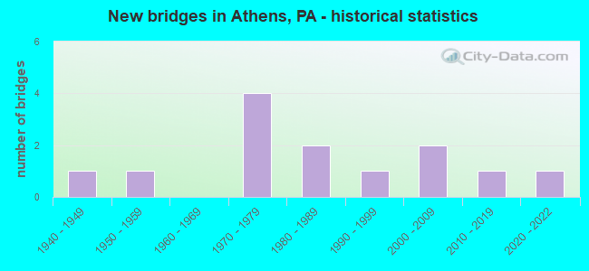
- New bridges - historical statistics
- 11940-1949
- 11950-1959
- 41970-1979
- 21980-1989
- 11990-1999
- 22000-2009
- 12010-2019
- 12020-2022

- Reconstructed bridges - Historical Statistics
- 22000-2009
- 12010-2019


- Bridge Condition - Deck
- 11.1%Excellent
- 11.1%Very good
- 66.7%Good
- 11.1%Satisfactory

- Bridge Condition - Superstructure
- 11.1%Excellent
- 11.1%Very good
- 55.6%Good
- 22.2%Satisfactory

- Bridge Condition - Substructure
- 11.1%Very good
- 55.6%Good
- 22.2%Satisfactory
- 11.1%Fair

- Bridge Condition - Channel
- 9.1%Very good
- 18.2%Good
- 18.2%Satisfactory
- 54.5%Fair

- Bridge Condition - Culverts
- 33.3%Very good
- 33.3%Good
- 33.3%Fair
Find on map >> Show street view
Structure Number: 613, Location: ATHENS TWP 1MI N LR 1097 (Lat: 41.948403, Lng: -76.518781), Route carried "on" structure: State highway 199, Year Built: 1949, Year Reconstructed: 2009, Status: Open, Structure Length: 5.27m (17.29ft), Average Daily Traffic: 2,139 (year 2022), Truck Traffic: 12%, Average Future Daily Traffic: 3,309 (year 2032), Design Load: HL 93, Features Intersected: CHEMUNG RIVER OVERFLOW C
Minimum Vertical Clearance: 30+ m (98+ ft), Kilometerpoint: 1.315, Lanes on structure: 2, Owner: State Highway Agency, Approaching Roadway Width: 8.5m (27.9ft), Material/Design: Steel, Design/Construction: Stringer/Multi-beam, Number Of Spans In Main Unit: 2, Length of Maximum Span: 25.3m (83.0ft), Curb or Sidewalk Widths: Left: 1.5m (4.9ft), Right: 0.1m (0.3ft), Curb-To-Curb Width: 9.4m (30.8ft), Out-to-Out Width: 11.6m (38.1ft)
Condition: Deck: Good, Superstructure: Very good, Substructure: Satisfactory, Channel: Fair, Operating Rating: 96.2 metric tons, Method Used To Determine Operating Rating: Load and Resistance Factor (LRFR), Inventory Rating: 74.4 metric tons, Method Used To Determine Inventory Rating: Load and Resistance Factor (LRFR), Structural Evaluation: Equal to present minimum criteria, Deck Geometry: Meets minimum limits, Waterway Adequacy: Superior to present desirable criteria, Approach Roadway Alignment: Equal to present desirable criteria, Length Of Structure Improvement: 5.30m (17.39ft), Designated Inspection Frequency: Every 24 months, Inspection Date: July 2020, Bridge Improvement Cost: $74,000, Roadway Improvement Cost: $217,000, Total Project Cost: $994,000, Deck Structure Type: Concrete Cast-file-Place, Wearing Surface/Protective System: Wearing Surface: Monolithic Concrete, Deck Protection: Epoxy Coated Reinforcing
Find on map >> Show street view
Structure Number: 6131, Location: ATHENS CHEMUNG RIVER BR. (Lat: 41.948619, Lng: -76.517447), Route carried "on" structure: State highway 199, Year Built: 1987, Year Reconstructed: 2009, Status: Open, Structure Length: 13.75m (45.11ft), Average Daily Traffic: 2,139 (year 2022), Truck Traffic: 12%, Average Future Daily Traffic: 3,309 (year 2032), Design Load: HS 25 or greater, Features Intersected: CHEMUNG RIVER
Minimum Vertical Clearance: 30+ m (98+ ft), Kilometerpoint: 1.315, Lanes on structure: 2, Owner: State Highway Agency, Approaching Roadway Width: 9.4m (30.8ft), Material/Design: Prestressed concrete continuous, Design/Construction: Box Beam or Girders - Single/Spread, Number Of Spans In Main Unit: 4, Length of Maximum Span: 34.4m (112.9ft), Curb or Sidewalk Widths: Left: 1.5m (4.9ft), Right: 0.2m (0.7ft), Curb-To-Curb Width: 9.1m (29.9ft), Out-to-Out Width: 11.4m (37.4ft)
Condition: Deck: Good, Superstructure: Good, Substructure: Good, Channel: Fair, Inventory Rating: 36.3 metric tons, Method Used To Determine Inventory Rating: Load Factor (LF), Structural Evaluation: Better than present minimum criteria, Deck Geometry: Meets minimum limits, Waterway Adequacy: Superior to present desirable criteria, Approach Roadway Alignment: Equal to present desirable criteria, Length Of Structure Improvement: 16.80m (55.12ft), Designated Inspection Frequency: Every 24 months, Underwater Inspection Frequency: Every 48 months, Inspection Date: July 2020, Underwater Inspection Date: July 2018, Deck Structure Type: Concrete Cast-file-Place, Wearing Surface/Protective System: Wearing Surface: Monolithic Concrete, Deck Protection: Epoxy Coated Reinforcing
Find on map >> Show street view
Structure Number: 6158, Location: US 220 CHEMUNG RIVER BRDG (Lat: 41.958633, Lng: -76.528189), Route carried "on" structure: Bypass US 220, Year Built: 1973, Status: Open, Structure Length: 21.85m (71.69ft), Average Daily Traffic: 11,030 (year 2022), Truck Traffic: 9%, Average Future Daily Traffic: 11,068 (year 2032), Design Load: HS 20, Features Intersected: CHEMUNG RIVER
Minimum Vertical Clearance: 30+ m (98+ ft), Kilometerpoint: 50.849, Lanes on structure: 4, Base Highway Network: Yes, Owner: State Highway Agency, Approaching Roadway Width: 22.6m (74.1ft), Skew: 34 degrees, Material/Design: Steel continuous, Design/Construction: Stringer/Multi-beam, Number Of Spans In Main Unit: 6, Length of Maximum Span: 39.3m (128.9ft), Curb or Sidewalk Widths: Left: 0.2m (0.7ft), Right: 0.2m (0.7ft), Curb-To-Curb Width: 23.8m (78.1ft), Out-to-Out Width: 25.0m (82.0ft)
Condition: Deck: Good, Superstructure: Good, Substructure: Good, Channel: Fair, Operating Rating: 53.5 metric tons, Method Used To Determine Operating Rating: Load Factor (LF), Inventory Rating: 31.8 metric tons, Method Used To Determine Inventory Rating: Load Factor (LF), Structural Evaluation: Better than present minimum criteria, Deck Geometry: Superior to present desirable criteria, Waterway Adequacy: Superior to present desirable criteria, Approach Roadway Alignment: Equal to present desirable criteria, Length Of Structure Improvement: 22.40m (73.49ft), Designated Inspection Frequency: Every 24 months, Underwater Inspection Frequency: Every 48 months, Inspection Date: July 2020, Underwater Inspection Date: July 2018, Bridge Improvement Cost: $224,000, Roadway Improvement Cost: $661,000, Total Project Cost: $3,029,000, Deck Structure Type: Concrete Cast-file-Place, Wearing Surface/Protective System: Wearing Surface: Epoxy Overlay, Deck Protection: Epoxy Coated Reinforcing
Find on map >> Show street view
Structure Number: 6159, Location: 2.5 MI.S.OF S.WAVERLY B. (Lat: 41.964944, Lng: -76.533667), Route carried "on" structure: US 220, Year Built: 1973, Status: Open, Structure Length: 3.23m (10.60ft), Average Daily Traffic: 8,140 (year 2020), Truck Traffic: 9%, Average Future Daily Traffic: 12,859 (year 2032), Design Load: HS 20, Features Intersected: SR 1064 SEG 0010
Minimum Vertical Clearance: 30+ m (98+ ft), Kilometerpoint: 52.371, Lanes on structure: 4, Lanes under structure: 2, Base Highway Network: Yes, Owner: State Highway Agency, Approaching Roadway Width: 29.0m (95.1ft), Skew: 30 degrees, Material/Design: Prestressed concrete, Design/Construction: Box Beam or Girders - Single/Spread, Number Of Spans In Main Unit: 3, Length of Maximum Span: 16.8m (55.1ft), Curb or Sidewalk Widths: Left: 0.2m (0.7ft), Right: 0.2m (0.7ft), Curb-To-Curb Width: 26.8m (87.9ft), Out-to-Out Width: 28.1m (92.2ft)
Condition: Deck: Good, Superstructure: Satisfactory, Substructure: Satisfactory, Operating Rating: 54.4 metric tons, Method Used To Determine Operating Rating: Load Factor (LF), Inventory Rating: 25.4 metric tons, Method Used To Determine Inventory Rating: Load Factor (LF), Structural Evaluation: Equal to present minimum criteria, Deck Geometry: Superior to present desirable criteria, Underclear: Equal to present minimum criteria, Approach Roadway Alignment: Equal to present desirable criteria, Length Of Structure Improvement: 4.10m (13.45ft), Designated Inspection Frequency: Every 24 months, Inspection Date: July 2020, Deck Structure Type: Concrete Cast-file-Place, Wearing Surface/Protective System: Wearing Surface: Epoxy Overlay
Find on map >> Show street view
Structure Number: 6293, Location: 2MI.N.OF SHESHEQUIN VIL. (Lat: 41.883672, Lng: -76.503333), Route carried "on" structure: State highway , Year Built: 1983, Status: Open, Structure Length: 0.98m (3.22ft), Average Daily Traffic: 1,606 (year 2021), Truck Traffic: 18%, Average Future Daily Traffic: 3,071 (year 2032), Design Load: H 10, Features Intersected: SPAULDING CREEK, Facility Carried by Structure: SR 1043
Minimum Vertical Clearance: 30+ m (98+ ft), Kilometerpoint: 11.764, Lanes on structure: 2, Owner: State Highway Agency, Approaching Roadway Width: 7.9m (25.9ft), Skew: 1 degrees, Material/Design: Prestressed concrete, Design/Construction: Box Beam or Girders - Multiple, Number Of Spans In Main Unit: 1, Length of Maximum Span: 9.1m (29.9ft), Curb or Sidewalk Widths: Left: 0.2m (0.7ft), Right: 0.2m (0.7ft), Curb-To-Curb Width: 8.8m (28.9ft), Out-to-Out Width: 9.9m (32.5ft)
Condition: Deck: Good, Superstructure: Good, Substructure: Good, Channel: Fair, Operating Rating: 77.1 metric tons, Method Used To Determine Operating Rating: Load Factor (LF), Inventory Rating: 42.6 metric tons, Method Used To Determine Inventory Rating: Load Factor (LF), Structural Evaluation: Better than present minimum criteria, Deck Geometry: Somewhat better than minimum adequacy, Waterway Adequacy: Better than present minimum criteria, Approach Roadway Alignment: Equal to present desirable criteria, Length Of Structure Improvement: 1.00m (3.28ft), Designated Inspection Frequency: Every 24 months, Inspection Date: July 2021, Deck Structure Type: Other, Wearing Surface/Protective System: Wearing Surface: Bituminous, Membrane: Preformed Fabric
Find on map >> Show street view
Structure Number: 6299, Location: 1 MI. E. OF ATHENS BORO (Lat: 41.962872, Lng: -76.509783), Route carried "on" structure: State highway , Year Built: 1990, Status: Open, Structure Length: 1.98m (6.50ft), Average Daily Traffic: 1,455 (year 2021), Truck Traffic: 8%, Average Future Daily Traffic: 1,667 (year 2032), Design Load: HS 20, Features Intersected: SATTERLEE CREEK, Facility Carried by Structure: SR 1043
Minimum Vertical Clearance: 30+ m (98+ ft), Kilometerpoint: 21.528, Lanes on structure: 2, Owner: State Highway Agency, Approaching Roadway Width: 7.3m (24.0ft), Skew: 1 degrees, Material/Design: Prestressed concrete, Design/Construction: Box Beam or Girders - Multiple, Number Of Spans In Main Unit: 1, Length of Maximum Span: 19.2m (63.0ft), Curb or Sidewalk Widths: Left: 0.2m (0.7ft), Right: 0.2m (0.7ft), Curb-To-Curb Width: 10.1m (33.1ft), Out-to-Out Width: 11.2m (36.7ft)
Condition: Deck: Satisfactory, Superstructure: Satisfactory, Substructure: Good, Channel: Satisfactory, Operating Rating: 89.8 metric tons, Method Used To Determine Operating Rating: Load Factor (LF), Inventory Rating: 50.8 metric tons, Method Used To Determine Inventory Rating: Load Factor (LF), Structural Evaluation: Equal to present minimum criteria, Deck Geometry: Somewhat better than minimum adequacy, Waterway Adequacy: Better than present minimum criteria, Approach Roadway Alignment: Equal to present desirable criteria, Length Of Structure Improvement: 1.90m (6.23ft), Designated Inspection Frequency: Every 48 months, Inspection Date: July 2018, Deck Structure Type: Concrete Cast-file-Place, Wearing Surface/Protective System: Wearing Surface: Monolithic Concrete, Deck Protection: Epoxy Coated Reinforcing
Find on map >> Show street view
Structure Number: 6342, Location: 3 MI. E. OF ATHENS BORO (Lat: 41.952333, Lng: -76.470675), Route carried "on" structure: State highway , Year Built: 1955, Year Reconstructed: 2010, Status: Open, Structure Length: 1.71m (5.61ft), Average Daily Traffic: 741 (year 2022), Truck Traffic: 3%, Average Future Daily Traffic: 971 (year 2032), Design Load: HL 93, Features Intersected: OVER SATTERLEE CREEK, Facility Carried by Structure: SR 1057
Minimum Vertical Clearance: 30+ m (98+ ft), Kilometerpoint: 12.297, Lanes on structure: 2, Owner: State Highway Agency, Approaching Roadway Width: 5.8m (19.0ft), Skew: 4 degrees, Material/Design: Steel, Design/Construction: Stringer/Multi-beam, Number Of Spans In Main Unit: 1, Length of Maximum Span: 16.2m (53.1ft), Curb-To-Curb Width: 9.1m (29.9ft), Out-to-Out Width: 9.8m (32.2ft)
Condition: Deck: Very good, Superstructure: Good, Substructure: Fair, Channel: Fair, Operating Rating: 45.4 metric tons, Method Used To Determine Operating Rating: Load and Resistance Factor (LRFR), Inventory Rating: 35.4 metric tons, Method Used To Determine Inventory Rating: Load and Resistance Factor (LRFR), Structural Evaluation: Somewhat better than minimum adequacy, Deck Geometry: Equal to present minimum criteria, Waterway Adequacy: Superior to present desirable criteria, Approach Roadway Alignment: Better than present minimum criteria, Length Of Structure Improvement: 1.70m (5.58ft), Designated Inspection Frequency: Every 24 months, Inspection Date: May 2021, Bridge Improvement Cost: $16,000, Roadway Improvement Cost: $50,000, Total Project Cost: $219,000, Deck Structure Type: Concrete Cast-file-Place, Wearing Surface/Protective System: Wearing Surface: Monolithic Concrete, Deck Protection: Epoxy Coated Reinforcing
Find on map >> Show street view
Structure Number: 6604, Location: 0.1 MI S. COTTONS CORNERS (Lat: 41.949611, Lng: -76.448236), Route carried "on" structure: City street , Year Built: 1977, Status: Open, Structure Length: 0.64m (2.10ft), Average Daily Traffic: 50 (year 2021), Average Future Daily Traffic: 77 (year 2043), Features Intersected: SATTERLEE CREEK, Facility Carried by Structure: T-902 LITCHFIELD
Minimum Vertical Clearance: 30+ m (98+ ft), Kilometerpoint: 0.000, Lanes on structure: 2, Owner: Town or Township Highway Agency, Approaching Roadway Width: 6.4m (21.0ft), Material/Design: Concrete, Design/Construction: Culvert, Number Of Spans In Main Unit: 1, Length of Maximum Span: 6.4m (21.0ft), Curb-To-Curb Width: 6.9m (22.6ft), Out-to-Out Width: 7.9m (25.9ft)
Condition: Channel: Fair, Culverts: Fair, Operating Rating: 54.4 metric tons, Method Used To Determine Operating Rating: Field evaluation and documented engineering judgment, Inventory Rating: 32.7 metric tons, Method Used To Determine Inventory Rating: Field evaluation and documented engineering judgment, Structural Evaluation: Somewhat better than minimum adequacy, Deck Geometry: Somewhat better than minimum adequacy, Waterway Adequacy: Equal to present desirable criteria, Approach Roadway Alignment: Equal to present desirable criteria, Length Of Structure Improvement: 1.30m (4.27ft), Designated Inspection Frequency: Every 24 months, Inspection Date: June 2021
Find on map >> Show street view
Structure Number: 43512, Location: 4 MI EAST OF ATHENS BORO (Lat: 41.951244, Lng: -76.447844), Route carried "on" structure: State highway , Year Built: 2006, Status: Open, Structure Length: 0.61m (2.00ft), Average Daily Traffic: 866 (year 2022), Truck Traffic: 6%, Average Future Daily Traffic: 1,080 (year 2032), Design Load: HL 93, Features Intersected: TR. TO SATTERLEE CREEK, Facility Carried by Structure: SR 1056
Minimum Vertical Clearance: 30+ m (98+ ft), Kilometerpoint: 6.782, Lanes on structure: 2, Owner: State Highway Agency, Approaching Roadway Width: 6.1m (20.0ft), Material/Design: Concrete, Design/Construction: Culvert, Number Of Spans In Main Unit: 1, Length of Maximum Span: 6.1m (20.0ft)
Condition: Channel: Satisfactory, Culverts: Good, Operating Rating: 89.8 metric tons, Method Used To Determine Operating Rating: Load and Resistance Factor (LRFR), Inventory Rating: 89.8 metric tons, Method Used To Determine Inventory Rating: Load and Resistance Factor (LRFR), Structural Evaluation: Better than present minimum criteria, Waterway Adequacy: Superior to present desirable criteria, Approach Roadway Alignment: Equal to present desirable criteria, Designated Inspection Frequency: Every 48 months, Inspection Date: May 2019
Find on map >> Show street view
Structure Number: 44055, Location: 0.1 mi. east of Athens (Lat: 41.957539, Lng: -76.514619), Route carried "on" structure: State highway , Year Built: 2006, Status: Open, Structure Length: 18.62m (61.09ft), Average Daily Traffic: 3,706 (year 2022), Truck Traffic: 4%, Average Future Daily Traffic: 4,410 (year 2032), Design Load: HL 93, Features Intersected: Susquehanna River, Facility Carried by Structure: SR 1056
Minimum Vertical Clearance: 30+ m (98+ ft), Kilometerpoint: 0.183, Lanes on structure: 2, Owner: State Highway Agency, Approaching Roadway Width: 7.9m (25.9ft), Material/Design: Prestressed concrete continuous, Design/Construction: Stringer/Multi-beam, Number Of Spans In Main Unit: 5, Length of Maximum Span: 36.6m (120.1ft), Curb or Sidewalk Widths: Left: 1.5m (4.9ft), Right: 0.2m (0.7ft), Curb-To-Curb Width: 9.8m (32.2ft), Out-to-Out Width: 12.5m (41.0ft)
Condition: Deck: Good, Superstructure: Good, Substructure: Good, Channel: Good, Operating Rating: 82.6 metric tons, Method Used To Determine Operating Rating: Load and Resistance Factor (LRFR), Inventory Rating: 44.5 metric tons, Method Used To Determine Inventory Rating: Load and Resistance Factor (LRFR), Structural Evaluation: Better than present minimum criteria, Deck Geometry: Meets minimum limits, Waterway Adequacy: Superior to present desirable criteria, Approach Roadway Alignment: Equal to present desirable criteria, Designated Inspection Frequency: Every 48 months, Underwater Inspection Frequency: Every 48 months, Inspection Date: May 2019, Underwater Inspection Date: August 2021, Deck Structure Type: Concrete Cast-file-Place, Wearing Surface/Protective System: Wearing Surface: Monolithic Concrete, Deck Protection: Epoxy Coated Reinforcing
Find on map >> Show street view
Structure Number: 4876, Location: 2.9 MI NORTH OF ULSTER (Lat: 41.887147, Lng: -76.490592), Route carried "on" structure: County highway , Year Built: 2014, Status: Open, Structure Length: 2.26m (7.41ft), Average Daily Traffic: 50 (year 2021), Average Future Daily Traffic: 54 (year 2043), Design Load: HL 93, Features Intersected: SPAULDING CREEK, Facility Carried by Structure: T-730 (CO BR #26)
Minimum Vertical Clearance: 30+ m (98+ ft), Kilometerpoint: 0.000, Lanes on structure: 2, Owner: County Highway Agency, Approaching Roadway Width: 6.1m (20.0ft), Skew: 4 degrees, Material/Design: Prestressed concrete, Design/Construction: Box Beam or Girders - Single/Spread, Number Of Spans In Main Unit: 1, Length of Maximum Span: 21.9m (71.9ft), Curb or Sidewalk Widths: Left: 0.2m (0.7ft), Right: 0.2m (0.7ft), Curb-To-Curb Width: 6.1m (20.0ft), Out-to-Out Width: 7.1m (23.3ft)
Condition: Deck: Excellent, Superstructure: Excellent, Substructure: Very good, Channel: Very good, Operating Rating: 62.2 metric tons, Method Used To Determine Operating Rating: Assigned ratings based on Load and Resistance Factor Design (LRFD) reported by rating factor (RF) using HL93 loadings, Inventory Rating: 46.7 metric tons, Method Used To Determine Inventory Rating: Assigned ratings based on Load and Resistance Factor Design (LRFD) reported by rating factor (RF) using HL93 loadings, Structural Evaluation: Equal to present desirable criteria, Deck Geometry: Somewhat better than minimum adequacy, Waterway Adequacy: Superior to present desirable criteria, Approach Roadway Alignment: Somewhat better than minimum adequacy, Designated Inspection Frequency: Every 24 months, Inspection Date: June 2021, Deck Structure Type: Concrete Cast-file-Place, Wearing Surface/Protective System: Wearing Surface: Monolithic Concrete, Deck Protection: Epoxy Coated Reinforcing
Find on map >> Show street view
Structure Number: 57392, Location: 3.0 mi. N of Sheshequin (Lat: 41.887139, Lng: -76.490583), Route carried "on" structure: City street , Year Built: 2020, Status: Open, Structure Length: 0.79m (2.59ft), Average Daily Traffic: 50 (year 2021), Truck Traffic: 4%, Average Future Daily Traffic: 77 (year 2043), Design Load: HL 93, Features Intersected: SPAULDING CREEK, Facility Carried by Structure: T-730 GOOSE HOLLOW
Minimum Vertical Clearance: 30+ m (98+ ft), Kilometerpoint: 0.000, Lanes on structure: 2, Owner: Town or Township Highway Agency, Approaching Roadway Width: 6.7m (22.0ft), Skew: 1 degrees, Material/Design: Aluminum, Iron, Design/Construction: Culvert, Number Of Spans In Main Unit: 1, Length of Maximum Span: 7.9m (25.9ft)
Condition: Channel: Good, Culverts: Very good, Operating Rating: 68.4 metric tons, Method Used To Determine Operating Rating: Assigned ratings based on Load and Resistance Factor Design (LRFD) reported by rating factor (RF) using HL93 loadings, Inventory Rating: 52.8 metric tons, Method Used To Determine Inventory Rating: Assigned ratings based on Load and Resistance Factor Design (LRFD) reported by rating factor (RF) using HL93 loadings, Structural Evaluation: Equal to present desirable criteria, Waterway Adequacy: Equal to present minimum criteria, Approach Roadway Alignment: Equal to present desirable criteria, Designated Inspection Frequency: Every 24 months, Inspection Date: June 2021
Find on map >> Show street view
Structure Number: 6159, Location: 2.5 MI.S.OF S.WAVERLY B. (Lat: 41.964944, Lng: -76.533667), Route carried "under" structure: State highway , Year Built: 1973, Structure Length: 0. m, Average Daily Traffic: 3,635 (year 2022), Truck Traffic: 5%, Features Intersected: SR 1064 SEG 0010, Facility Carried by Structure: US 220
Minimum Vertical Clearance: 4.52m (14.83ft), Kilometerpoint: 0.000, Lanes on structure: 4, Lanes under structure: 2, Material/Design: Prestressed concrete, Design/Construction: Box Beam or Girders - Single/Spread, Length of Maximum Span: 16.8m (55.1ft)