Bridge Statistics for Atglen, Pennsylvania (PA)
Condition, Traffic, Stress, Structural Evaluation, Project Costs
- National Bridge Inventory (NBI) Statistics
- 14Number of bridges
- 102ft / 31.2mTotal length
- $893,000Total costs
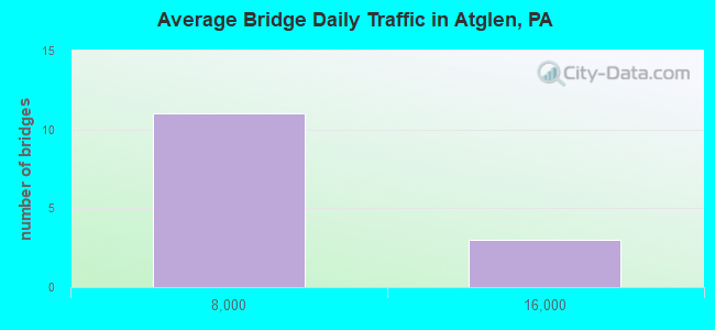
- 55,118Total average daily traffic
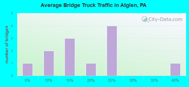
- 12,362Total average daily truck traffic
- National Bridge Inventory (NBI) Registered Bridges for Atglen
- No street view available for this location
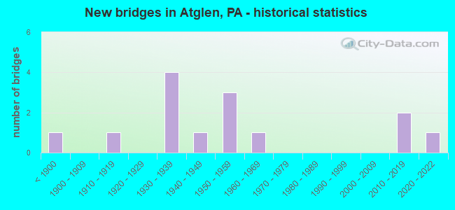
- New bridges - historical statistics
- 1Before 1900
- 11910-1919
- 41930-1939
- 11940-1949
- 31950-1959
- 11960-1969
- 22010-2019
- 12020-2022
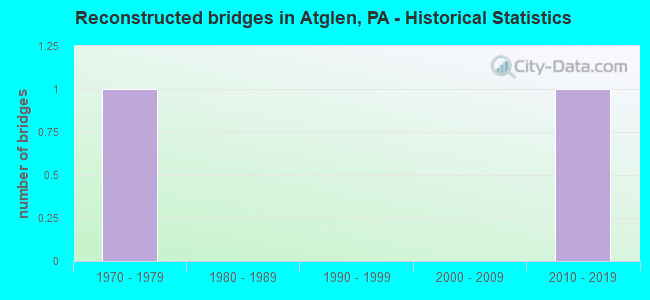
- Reconstructed bridges - Historical Statistics
- 11970-1979
- 01980-1989
- 01990-1999
- 02000-2009
- 12010-2019
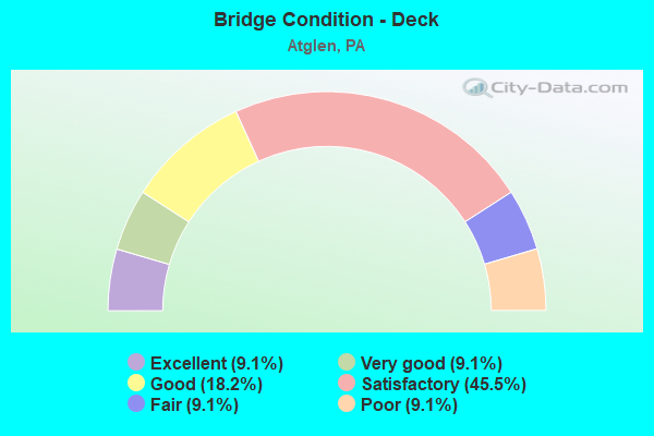
- Bridge Condition - Deck
- 9.1%Excellent
- 9.1%Very good
- 18.2%Good
- 45.5%Satisfactory
- 9.1%Fair
- 9.1%Poor
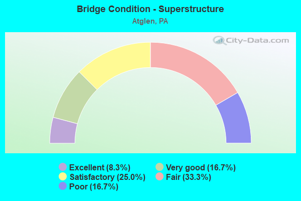
- Bridge Condition - Superstructure
- 8.3%Excellent
- 16.7%Very good
- 25.0%Satisfactory
- 33.3%Fair
- 16.7%Poor
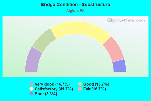
- Bridge Condition - Substructure
- 16.7%Very good
- 16.7%Good
- 41.7%Satisfactory
- 16.7%Fair
- 8.3%Poor
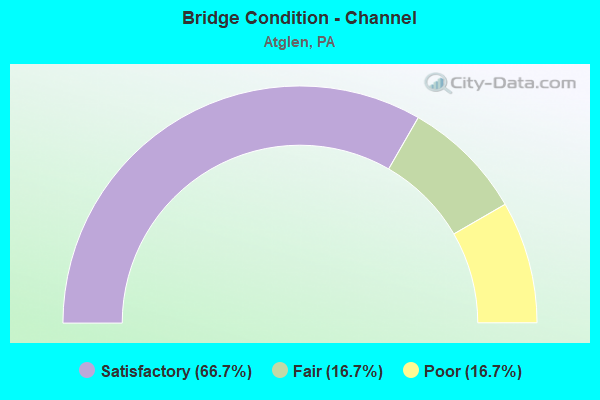
- Bridge Condition - Channel
- 66.7%Satisfactory
- 16.7%Fair
- 16.7%Poor
Find on map >> Show street view
Structure Number: 10021, Location: ATGLEN 26H12 (Lat: 39.945833, Lng: -75.967850), Route carried "on" structure: State highway 41, Year Built: 1954, Year Reconstructed: 2015, Status: Open, Structure Length: 1.43m (4.69ft), Average Daily Traffic: 13,508 (year 2020), Truck Traffic: 20%, Average Future Daily Traffic: 28,680 (year 2032), Design Load: HL 93, Features Intersected: OFFICERS RUN, Facility Carried by Structure: NEWPORT PIKE
Minimum Vertical Clearance: 30+ m (98+ ft), Kilometerpoint: 28.316, Lanes on structure: 2, Base Highway Network: Yes, Owner: State Highway Agency, Approaching Roadway Width: 15.5m (50.9ft), Skew: 24 degrees, Material/Design: Steel, Design/Construction: Stringer/Multi-beam, Number Of Spans In Main Unit: 1, Length of Maximum Span: 12.8m (42.0ft), Curb or Sidewalk Widths: Left: 0.2m (0.7ft), Right: 0.2m (0.7ft), Curb-To-Curb Width: 15.6m (51.2ft), Out-to-Out Width: 16.8m (55.1ft)
Condition: Deck: Good, Superstructure: Very good, Substructure: Good, Channel: Satisfactory, Operating Rating: 64.2 metric tons, Method Used To Determine Operating Rating: Assigned ratings based on Load and Resistance Factor Design (LRFD) reported by rating factor (RF) using HL93 loadings, Inventory Rating: 49.2 metric tons, Method Used To Determine Inventory Rating: Assigned ratings based on Load and Resistance Factor Design (LRFD) reported by rating factor (RF) using HL93 loadings, Structural Evaluation: Better than present minimum criteria, Deck Geometry: Superior to present desirable criteria, Waterway Adequacy: Equal to present desirable criteria, Approach Roadway Alignment: Equal to present desirable criteria, Length Of Structure Improvement: 1.90m (6.23ft), Designated Inspection Frequency: Every 24 months, Inspection Date: November 2019, Deck Structure Type: Concrete Precast Panels, Wearing Surface/Protective System: Wearing Surface: Epoxy Overlay, Deck Protection: Epoxy Coated Reinforcing
Find on map >> Show street view
Structure Number: 10022, Location: ATGLEN 26H11 (Lat: 39.951064, Lng: -75.971206), Route carried "on" structure: State highway 41, Year Built: 1954, Status: Open, Structure Length: 12.10m (39.70ft), Average Daily Traffic: 13,466 (year 2022), Truck Traffic: 37%, Average Future Daily Traffic: 12,858 (year 2032), Design Load: HS 20, Features Intersected: AMTRAK MAIN LINE E-W, Facility Carried by Structure: NEWPORT PIKE
Minimum Vertical Clearance: 30+ m (98+ ft), Kilometerpoint: 28.904, Lanes on structure: 2, Lanes under structure: 2, Base Highway Network: Yes, Owner: State Highway Agency, Approaching Roadway Width: 11.6m (38.1ft), Skew: 1 degrees, Material/Design: Steel, Design/Construction: Stringer/Multi-beam, Number Of Spans In Main Unit: 2, Number Of Approach Spans: 4, Length of Maximum Span: 21.3m (69.9ft), Curb or Sidewalk Widths: Left: 0.9m (3.0ft), Right: 0.9m (3.0ft), Curb-To-Curb Width: 11.6m (38.1ft), Out-to-Out Width: 14.1m (46.3ft)
Condition: Deck: Satisfactory, Superstructure: Satisfactory, Substructure: Satisfactory, Operating Rating: 62.6 metric tons, Method Used To Determine Operating Rating: Load Factor (LF), Inventory Rating: 37.2 metric tons, Method Used To Determine Inventory Rating: Load Factor (LF), Structural Evaluation: Equal to present minimum criteria, Deck Geometry: Somewhat better than minimum adequacy, Underclear: High priority of corrective action, Approach Roadway Alignment: Equal to present desirable criteria, Length Of Structure Improvement: 12.10m (39.70ft), Designated Inspection Frequency: Every 24 months, Inspection Date: Febuary 2020, Bridge Improvement Cost: $39,000, Roadway Improvement Cost: $116,000, Total Project Cost: $531,000, Deck Structure Type: Concrete Cast-file-Place, Wearing Surface/Protective System: Wearing Surface: Monolithic Concrete
Find on map >> Show street view
Structure Number: 10223, Location: NEAR PARKESBURG 26H11 (Lat: 39.947483, Lng: -75.967353), Route carried "on" structure: State highway 372, Year Built: 1937, Status: Open, Structure Length: 1.28m (4.20ft), Average Daily Traffic: 3,124 (year 2022), Truck Traffic: 20%, Average Future Daily Traffic: 4,383 (year 2032), Design Load: H 20, Features Intersected: OFFICERS RUN, Facility Carried by Structure: LOWER VALLEY ROAD
Minimum Vertical Clearance: 30+ m (98+ ft), Kilometerpoint: 2.256, Lanes on structure: 2, Owner: State Highway Agency, Approaching Roadway Width: 6.4m (21.0ft), Skew: 1 degrees, Material/Design: Concrete, Design/Construction: Slab, Number Of Spans In Main Unit: 2, Length of Maximum Span: 6.1m (20.0ft), Curb-To-Curb Width: 9.3m (30.5ft), Out-to-Out Width: 10.0m (32.8ft)
Condition: Deck: Poor, Superstructure: Poor, Substructure: Poor, Channel: Poor, Operating Rating: 49.9 metric tons, Method Used To Determine Operating Rating: Load Factor (LF), Inventory Rating: 29.9 metric tons, Method Used To Determine Inventory Rating: Load Factor (LF), Structural Evaluation: Meets minimum limits, Deck Geometry: Meets minimum limits, Waterway Adequacy: Somewhat better than minimum adequacy, Approach Roadway Alignment: Equal to present desirable criteria, Length Of Structure Improvement: 1.70m (5.58ft), Designated Inspection Frequency: Every 24 months, Inspection Date: April 2020, Deck Structure Type: Concrete Cast-file-Place, Wearing Surface/Protective System: Wearing Surface: Bituminous
Find on map >> Show street view
Structure Number: 10521, Location: NEAR STEELVILLE 35D06 (Lat: 39.904847, Lng: -75.996128), Route carried "on" structure: State highway , Year Built: 1941, Status: Open, Structure Length: 2.65m (8.69ft), Average Daily Traffic: 460 (year 2021), Truck Traffic: 10%, Average Future Daily Traffic: 550 (year 2032), Design Load: H 20, Features Intersected: OCTORARO CREEK, Facility Carried by Structure: STEELVILLE ROAD
Minimum Vertical Clearance: 30+ m (98+ ft), Kilometerpoint: 0.000, Lanes on structure: 2, Owner: State Highway Agency, Approaching Roadway Width: 6.1m (20.0ft), Material/Design: Concrete, Design/Construction: Tee Beam, Number Of Spans In Main Unit: 2, Length of Maximum Span: 12.8m (42.0ft), Curb-To-Curb Width: 7.3m (24.0ft), Out-to-Out Width: 8.4m (27.6ft)
Condition: Deck: Satisfactory, Superstructure: Fair, Substructure: Satisfactory, Channel: Fair, Operating Rating: 60.8 metric tons, Method Used To Determine Operating Rating: Load Factor (LF), Inventory Rating: 36.3 metric tons, Method Used To Determine Inventory Rating: Load Factor (LF), Structural Evaluation: Somewhat better than minimum adequacy, Deck Geometry: Meets minimum limits, Waterway Adequacy: Better than present minimum criteria, Approach Roadway Alignment: Equal to present desirable criteria, Length Of Structure Improvement: 3.20m (10.50ft), Designated Inspection Frequency: Every 24 months, Inspection Date: April 2020, Deck Structure Type: Concrete Cast-file-Place, Wearing Surface/Protective System: Wearing Surface: Integral Concrete, Deck Protection: Epoxy Coated Reinforcing
Find on map >> Show street view
Structure Number: 10541, Location: ATGLEN 26H10 (Lat: 39.952364, Lng: -75.970533), Route carried "on" structure: State highway , Year Built: 1937, Status: Open, Structure Length: 0.70m (2.30ft), Average Daily Traffic: 511 (year 2021), Truck Traffic: 6%, Average Future Daily Traffic: 794 (year 2032), Design Load: H 20, Features Intersected: OFFICERS RUN, Facility Carried by Structure: UPPER VALLEY ROAD
Minimum Vertical Clearance: 30+ m (98+ ft), Kilometerpoint: 0.512, Lanes on structure: 2, Owner: State Highway Agency, Approaching Roadway Width: 5.5m (18.0ft), Skew: 1 degrees, Material/Design: Steel, Design/Construction: Stringer/Multi-beam, Number Of Spans In Main Unit: 1, Length of Maximum Span: 6.4m (21.0ft), Curb-To-Curb Width: 6.8m (22.3ft), Out-to-Out Width: 7.4m (24.3ft)
Condition: Deck: Fair, Superstructure: Fair, Substructure: Satisfactory, Channel: Satisfactory, Inventory Rating: 63.5 metric tons, Method Used To Determine Inventory Rating: Load Factor (LF), Structural Evaluation: Somewhat better than minimum adequacy, Deck Geometry: Meets minimum limits, Waterway Adequacy: Equal to present minimum criteria, Approach Roadway Alignment: Equal to present desirable criteria, Length Of Structure Improvement: 1.30m (4.27ft), Designated Inspection Frequency: Every 24 months, Inspection Date: April 2020, Deck Structure Type: Open Grating
Find on map >> Show street view
Structure Number: 10543, Location: NEAR BOYDS CORNER 26J7 (Lat: 39.968619, Lng: -75.961797), Route carried "on" structure: State highway , Year Built: 1938, Status: Open, Structure Length: 1.04m (3.41ft), Average Daily Traffic: 875 (year 2020), Truck Traffic: 4%, Average Future Daily Traffic: 1,603 (year 2032), Design Load: H 20, Features Intersected: OFFICERS RUN, Facility Carried by Structure: STRASBURG ROAD
Minimum Vertical Clearance: 30+ m (98+ ft), Kilometerpoint: 1.909, Lanes on structure: 2, Owner: State Highway Agency, Approaching Roadway Width: 5.2m (17.1ft), Skew: 1 degrees, Material/Design: Concrete, Design/Construction: Tee Beam, Number Of Spans In Main Unit: 1, Length of Maximum Span: 9.1m (29.9ft), Curb-To-Curb Width: 7.2m (23.6ft), Out-to-Out Width: 7.9m (25.9ft)
Condition: Deck: Satisfactory, Superstructure: Fair, Substructure: Satisfactory, Channel: Satisfactory, Operating Rating: 56.2 metric tons, Method Used To Determine Operating Rating: Load Factor (LF), Inventory Rating: 33.6 metric tons, Method Used To Determine Inventory Rating: Load Factor (LF), Structural Evaluation: Somewhat better than minimum adequacy, Deck Geometry: Meets minimum limits, Waterway Adequacy: Better than present minimum criteria, Approach Roadway Alignment: Equal to present desirable criteria, Length Of Structure Improvement: 1.60m (5.25ft), Designated Inspection Frequency: Every 24 months, Inspection Date: June 2020, Bridge Improvement Cost: $6,000, Roadway Improvement Cost: $18,000, Total Project Cost: $82,000, Deck Structure Type: Concrete Cast-file-Place, Wearing Surface/Protective System: Wearing Surface: Bituminous
Find on map >> Show street view
Structure Number: 10569, Location: NEAR ATGLEN 26H09 (Lat: 39.956775, Lng: -75.969783), Route carried "on" structure: State highway , Year Built: 1916, Status: Open, Structure Length: 1.83m (6.00ft), Average Daily Traffic: 2,161 (year 2022), Truck Traffic: 20%, Average Future Daily Traffic: 2,405 (year 2032), Design Load: H 15, Features Intersected: OFFICERS RUN, Facility Carried by Structure: SWAN ROAD
Minimum Vertical Clearance: 30+ m (98+ ft), Kilometerpoint: 0.444, Lanes on structure: 2, Owner: State Highway Agency, Approaching Roadway Width: 8.5m (27.9ft), Material/Design: Masonry, Design/Construction: Arch - Deck, Number Of Spans In Main Unit: 2, Length of Maximum Span: 9.1m (29.9ft), Curb-To-Curb Width: 5.9m (19.4ft), Out-to-Out Width: 6.7m (22.0ft)
Condition: Superstructure: Fair, Substructure: Fair, Channel: Poor, Operating Rating: 55.3 metric tons, Method Used To Determine Operating Rating: Field evaluation and documented engineering judgment, Inventory Rating: 27.2 metric tons, Method Used To Determine Inventory Rating: Field evaluation and documented engineering judgment, Structural Evaluation: Somewhat better than minimum adequacy, Deck Geometry: High priority of replacement, Waterway Adequacy: Equal to present desirable criteria, Approach Roadway Alignment: Equal to present desirable criteria, Length Of Structure Improvement: 2.50m (8.20ft), Designated Inspection Frequency: Every 24 months, Inspection Date: April 2020, Bridge Improvement Cost: $13,000, Roadway Improvement Cost: $37,000, Total Project Cost: $172,000
Find on map >> Show street view
Structure Number: 1057, Location: NEAR ATGLEN 26H9 (Lat: 39.961353, Lng: -75.968056), Route carried "on" structure: State highway , Year Built: 1937, Status: Open, Structure Length: 0.91m (2.99ft), Average Daily Traffic: 2,137 (year 2022), Truck Traffic: 18%, Average Future Daily Traffic: 1,505 (year 2032), Design Load: H 20, Features Intersected: OFFICERS RUN, Facility Carried by Structure: SWAN ROAD
Minimum Vertical Clearance: 30+ m (98+ ft), Kilometerpoint: 0.463, Lanes on structure: 2, Owner: State Highway Agency, Approaching Roadway Width: 5.5m (18.0ft), Material/Design: Concrete, Design/Construction: Tee Beam, Number Of Spans In Main Unit: 1, Length of Maximum Span: 7.9m (25.9ft), Curb-To-Curb Width: 7.2m (23.6ft), Out-to-Out Width: 7.9m (25.9ft)
Condition: Deck: Satisfactory, Superstructure: Satisfactory, Substructure: Fair, Channel: Satisfactory, Operating Rating: 60.8 metric tons, Method Used To Determine Operating Rating: Load Factor (LF), Inventory Rating: 36.3 metric tons, Method Used To Determine Inventory Rating: Load Factor (LF), Structural Evaluation: Somewhat better than minimum adequacy, Deck Geometry: High priority of replacement, Waterway Adequacy: Equal to present minimum criteria, Approach Roadway Alignment: Equal to present desirable criteria, Length Of Structure Improvement: 1.50m (4.92ft), Designated Inspection Frequency: Every 24 months, Inspection Date: June 2020, Bridge Improvement Cost: $6,000, Roadway Improvement Cost: $18,000, Total Project Cost: $82,000, Deck Structure Type: Concrete Cast-file-Place, Wearing Surface/Protective System: Wearing Surface: Bituminous
Find on map >> Show street view
Structure Number: 21528, Location: 1 MI SOUTH CHRISTIANA (Lat: 39.938853, Lng: -75.989481), Route carried "on" structure: State highway , Year Built: 1966, Year Reconstructed: 1983, Status: Open, Structure Length: 0.70m (2.30ft), Average Daily Traffic: 1,211 (year 2022), Truck Traffic: 6%, Average Future Daily Traffic: 1,183 (year 2032), Design Load: HS 20+Mod, Features Intersected: VALLEY RUN, Facility Carried by Structure: SR 2009
Minimum Vertical Clearance: 30+ m (98+ ft), Kilometerpoint: 19.996, Lanes on structure: 2, Owner: State Highway Agency, Approaching Roadway Width: 9.1m (29.9ft), Skew: 1 degrees, Material/Design: Steel, Design/Construction: Stringer/Multi-beam, Number Of Spans In Main Unit: 1, Length of Maximum Span: 6.1m (20.0ft), Curb-To-Curb Width: 9.4m (30.8ft), Out-to-Out Width: 10.5m (34.4ft)
Condition: Deck: Good, Superstructure: Satisfactory, Substructure: Good, Channel: Fair, Operating Rating: 89.8 metric tons, Method Used To Determine Operating Rating: Load Factor (LF), Inventory Rating: 61.7 metric tons, Method Used To Determine Inventory Rating: Load Factor (LF), Structural Evaluation: Equal to present minimum criteria, Deck Geometry: Somewhat better than minimum adequacy, Waterway Adequacy: Equal to present minimum criteria, Approach Roadway Alignment: Equal to present desirable criteria, Length Of Structure Improvement: 1.30m (4.27ft), Designated Inspection Frequency: Every 24 months, Inspection Date: December 2019, Deck Structure Type: Concrete Cast-file-Place, Wearing Surface/Protective System: Wearing Surface: Monolithic Concrete, Deck Protection: Epoxy Coated Reinforcing
Find on map >> Show street view
Structure Number: 22062, Location: 3/4 MILE SE OF SR 2009 (Lat: 39.931458, Lng: -75.981614), Route carried "on" structure: City street , Year Built: 1880, Status: Posted for load, Structure Length: 2.65m (8.69ft), Average Daily Traffic: 150 (year 2012), Average Future Daily Traffic: 175 (year 2032), Features Intersected: E OCTORARO CREEK, Facility Carried by Structure: UNNAMED RD
Minimum Vertical Clearance: 3.05m (10.01ft), Kilometerpoint: 0.000, Lanes on structure: 1, Owner: County Highway Agency, Approaching Roadway Width: 4.9m (16.1ft), Material/Design: Wood or Timber, Design/Construction: Truss - Thru, Number Of Spans In Main Unit: 1, Length of Maximum Span: 26.5m (86.9ft), Curb-To-Curb Width: 4.7m (15.4ft), Out-to-Out Width: 5.6m (18.4ft)
Condition: Deck: Satisfactory, Superstructure: Poor, Substructure: Satisfactory, Channel: Satisfactory, Operating Rating: 3.6 metric tons, Method Used To Determine Operating Rating: Allowable Stress (AS), Inventory Rating: 1.8 metric tons, Method Used To Determine Inventory Rating: Allowable Stress (AS), Structural Evaluation: High priority of corrective action, Deck Geometry: High priority of replacement, Waterway Adequacy: Equal to present desirable criteria, Approach Roadway Alignment: Somewhat better than minimum adequacy, Bridge Posting: Required (Relationship of Operating Rating to Maximum Legal Load: > 39.9% below), Length Of Structure Improvement: 2.60m (8.53ft), Designated Inspection Frequency: Every 24 months, Other Special Inspection Frequency: Every 12 months, Inspection Date: June 2020, Other Special Inspection Date: June 2021, Bridge Improvement Cost: $2,000, Roadway Improvement Cost: $19,000, Total Project Cost: $26,000, Deck Structure Type: Wood or Timber
Find on map >> Show street view
Structure Number: 47554, Location: 2000' W SR 41 3577E10 (Lat: 39.942864, Lng: -75.971664), Route carried "on" structure: City street , Year Built: 2012, Status: Open, Structure Length: 1.65m (5.41ft), Average Daily Traffic: 1,501 (year 2001), Truck Traffic: 10%, Average Future Daily Traffic: 2,000 (year 2021), Design Load: HL 93, Features Intersected: VALLEY CREEK, Facility Carried by Structure: MAIN STREET
Minimum Vertical Clearance: 30+ m (98+ ft), Kilometerpoint: 0.000, Lanes on structure: 2, Owner: City or Municipal Highway Agency, Approaching Roadway Width: 7.9m (25.9ft), Material/Design: Prestressed concrete, Design/Construction: Tee Beam, Number Of Spans In Main Unit: 1, Length of Maximum Span: 15.8m (51.8ft), Curb or Sidewalk Widths: Left: 1.7m (5.6ft), Right: 0.0m, Curb-To-Curb Width: 8.3m (27.2ft), Out-to-Out Width: 11.0m (36.1ft)
Condition: Deck: Very good, Superstructure: Very good, Substructure: Very good, Channel: Satisfactory, Operating Rating: 73.5 metric tons, Method Used To Determine Operating Rating: Assigned ratings based on Load and Resistance Factor Design (LRFD) reported by rating factor (RF) using HL93 loadings, Inventory Rating: 39.5 metric tons, Method Used To Determine Inventory Rating: Assigned ratings based on Load and Resistance Factor Design (LRFD) reported by rating factor (RF) using HL93 loadings, Structural Evaluation: Equal to present desirable criteria, Deck Geometry: Meets minimum limits, Waterway Adequacy: Equal to present desirable criteria, Approach Roadway Alignment: Better than present minimum criteria, Designated Inspection Frequency: Every 24 months, Inspection Date: January 2021, Deck Structure Type: Concrete Cast-file-Place, Wearing Surface/Protective System: Wearing Surface: Monolithic Concrete, Membrane: Other, Deck Protection: Epoxy Coated Reinforcing
Find on map >> Show street view
Structure Number: 5279, Location: 1/4 MI. S. PA372 26H12 (Lat: 39.943989, Lng: -75.966728), Route carried "on" structure: State highway 41, Year Built: 2015, Status: Open, Structure Length: 1.46m (4.79ft), Average Daily Traffic: 13,508 (year 2020), Truck Traffic: 20%, Average Future Daily Traffic: 14,340 (year 2032), Design Load: HL 93, Features Intersected: VALLEY CREEK, Facility Carried by Structure: NEWPORT PIKE
Minimum Vertical Clearance: 30+ m (98+ ft), Kilometerpoint: 27.478, Lanes on structure: 2, Base Highway Network: Yes, Owner: State Highway Agency, Approaching Roadway Width: 7.3m (24.0ft), Material/Design: Concrete, Design/Construction: Culvert, Number Of Spans In Main Unit: 1, Length of Maximum Span: 14.6m (47.9ft)
Condition: Channel: Satisfactory, Culverts: Very good, Operating Rating: 61.6 metric tons, Method Used To Determine Operating Rating: Assigned ratings based on Load and Resistance Factor Design (LRFD) reported by rating factor (RF) using HL93 loadings, Inventory Rating: 45.4 metric tons, Method Used To Determine Inventory Rating: Assigned ratings based on Load and Resistance Factor Design (LRFD) reported by rating factor (RF) using HL93 loadings, Structural Evaluation: Equal to present desirable criteria, Waterway Adequacy: Superior to present desirable criteria, Approach Roadway Alignment: Equal to present desirable criteria, Designated Inspection Frequency: Every 24 months, Inspection Date: December 2019
Find on map >> Show street view
Structure Number: 67676, Location: 1200 FT EAST OF SR 2009 (Lat: 39.937472, Lng: -75.984322), Route carried "on" structure: City street , Year Built: 2020, Status: Open, Structure Length: 2.80m (9.19ft), Average Daily Traffic: 455 (year 2012), Average Future Daily Traffic: 610 (year 2032), Design Load: HL 93, Features Intersected: EAST OCTORARO CREEK, Facility Carried by Structure: MILL CREEK ROAD
Minimum Vertical Clearance: 30+ m (98+ ft), Kilometerpoint: 0.000, Lanes on structure: 2, Owner: County Highway Agency, Approaching Roadway Width: 6.1m (20.0ft), Material/Design: Prestressed concrete continuous, Design/Construction: Box Beam or Girders - Single/Spread, Number Of Spans In Main Unit: 2, Length of Maximum Span: 13.4m (44.0ft), Curb or Sidewalk Widths: Left: 0.2m (0.7ft), Right: 0.2m (0.7ft), Curb-To-Curb Width: 7.3m (24.0ft), Out-to-Out Width: 8.5m (27.9ft)
Condition: Deck: Excellent, Superstructure: Excellent, Substructure: Very good, Channel: Satisfactory, Operating Rating: 46.3 metric tons, Method Used To Determine Operating Rating: Assigned ratings based on Load and Resistance Factor Design (LRFD) reported by rating factor (RF) using HL93 loadings, Inventory Rating: 35.6 metric tons, Method Used To Determine Inventory Rating: Assigned ratings based on Load and Resistance Factor Design (LRFD) reported by rating factor (RF) using HL93 loadings, Structural Evaluation: Equal to present desirable criteria, Deck Geometry: Meets minimum limits, Waterway Adequacy: Equal to present minimum criteria, Approach Roadway Alignment: Better than present minimum criteria, Designated Inspection Frequency: Every 24 months, Inspection Date: September 2020, Deck Structure Type: Concrete Cast-file-Place, Wearing Surface/Protective System: Wearing Surface: Monolithic Concrete, Deck Protection: Epoxy Coated Reinforcing
Find on map >> Show street view
Structure Number: 10022, Location: ATGLEN 26H11 (Lat: 39.951064, Lng: -75.971206), Route carried "under" structure: State highway , Year Built: 1954, Structure Length: 0. m, Average Daily Traffic: 2,051 (year 2022), Truck Traffic: 10%, Features Intersected: AMTRAK MAIN LINE E-W, Facility Carried by Structure: NEWPORT PIKE
Minimum Vertical Clearance: 14.76m (48.43ft), Kilometerpoint: 0.000, Lanes on structure: 2, Lanes under structure: 2, Material/Design: Steel, Design/Construction: Stringer/Multi-beam, Length of Maximum Span: 21.3m (69.9ft)