Bridge Statistics for Atascocita, Texas (TX)
Condition, Traffic, Stress, Structural Evaluation, Project Costs
- National Bridge Inventory (NBI) Statistics
- 15Number of bridges
- 272ft / 82.7mTotal length
- $27,000Total costs
- 14,100Total average daily traffic
- 250Total average daily truck traffic
- 22,500Total future (year 2028) average daily traffic
- National Bridge Inventory (NBI) Registered Bridges for Atascocita
- No street view available for this location
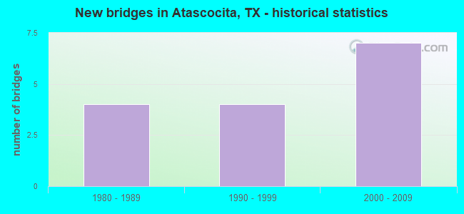
- New bridges - historical statistics
- 41980-1989
- 41990-1999
- 72000-2009


- Bridge Condition - Deck
- 77.8%Good
- 11.1%Satisfactory
- 11.1%Fair

- Bridge Condition - Superstructure
- 11.1%Very good
- 88.9%Good

- Bridge Condition - Substructure
- 11.1%Very good
- 44.4%Good
- 44.4%Satisfactory

- Bridge Condition - Channel
- 23.1%Very good
- 46.2%Good
- 15.4%Satisfactory
- 15.4%Fair

- Bridge Condition - Culverts
- 66.7%Good
- 33.3%Satisfactory
Find on map >> Show street view
Structure Number: 121020A15719001, Location: 0.05 MI N OF ATASCA CRK D (Lat: 29.987561, Lng: -95.175186), Route carried "on" structure: County highway , Year Built: 2002, Status: Open, Structure Length: 0.67m (2.20ft), Average Daily Traffic: 500 (year 2014), Average Future Daily Traffic: 750 (year 2034), Design Load: HS 20, Features Intersected: HCFCD DITCH, Facility Carried by Structure: ATASCA SOUTH DRIVE
Minimum Vertical Clearance: 30+ m (98+ ft), Kilometerpoint: 0.080, Lanes on structure: 2, Owner: County Highway Agency, Approaching Roadway Width: 8.2m (26.9ft), Material/Design: Concrete, Design/Construction: Culvert, Number Of Spans In Main Unit: 2, Length of Maximum Span: 3.0m (9.8ft), Curb or Sidewalk Widths: Left: 1.2m (3.9ft), Right: 1.2m (3.9ft), Curb-To-Curb Width: 8.2m (26.9ft), Out-to-Out Width: 30.5m (100.1ft)
Condition: Channel: Very good, Culverts: Good, Operating Rating: 54.4 metric tons, Method Used To Determine Operating Rating: Assigned rating based on Load Factor Design (LFD) reported in metric tons, Inventory Rating: 32.7 metric tons, Method Used To Determine Inventory Rating: Assigned rating based on Load Factor Design (LFD) reported in metric tons, Structural Evaluation: Better than present minimum criteria, Deck Geometry: Somewhat better than minimum adequacy, Waterway Adequacy: Better than present minimum criteria, Approach Roadway Alignment: Equal to present desirable criteria, Designated Inspection Frequency: Every 24 months, Inspection Date: December 2021, Deck Structure Type: Concrete Cast-file-Place
Find on map >> Show street view
Structure Number: 121020A16301001, Location: 0.05 MI N OF YELLOWSTONE (Lat: 29.987503, Lng: -95.179444), Route carried "on" structure: County highway , Year Built: 2001, Status: Open, Structure Length: 0.82m (2.69ft), Average Daily Traffic: 400 (year 2014), Average Future Daily Traffic: 750 (year 2034), Features Intersected: HCFCD DITCH, Facility Carried by Structure: GRAND CANYON WAY
Minimum Vertical Clearance: 30+ m (98+ ft), Kilometerpoint: 0.080, Lanes on structure: 2, Owner: County Highway Agency, Approaching Roadway Width: 8.2m (26.9ft), Material/Design: Concrete, Design/Construction: Culvert, Number Of Spans In Main Unit: 2, Length of Maximum Span: 3.0m (9.8ft), Curb or Sidewalk Widths: Left: 1.2m (3.9ft), Right: 1.2m (3.9ft), Curb-To-Curb Width: 8.2m (26.9ft), Out-to-Out Width: 15.9m (52.2ft)
Condition: Channel: Good, Culverts: Good, Operating Rating: 32.7 metric tons, Method Used To Determine Operating Rating: Field evaluation and documented engineering judgment, Inventory Rating: 24.5 metric tons, Method Used To Determine Inventory Rating: Field evaluation and documented engineering judgment, Structural Evaluation: Equal to present minimum criteria, Deck Geometry: Somewhat better than minimum adequacy, Waterway Adequacy: Better than present minimum criteria, Approach Roadway Alignment: Equal to present desirable criteria, Designated Inspection Frequency: Every 24 months, Inspection Date: December 2021, Deck Structure Type: Concrete Cast-file-Place, Wearing Surface/Protective System: Wearing Surface: Monolithic Concrete
Find on map >> Show street view
Structure Number: 121020A16311001, Location: 0.05 MI W OF YELLOWSTON (Lat: 29.984486, Lng: -95.184042), Route carried "on" structure: County highway , Year Built: 1995, Status: Open, Structure Length: 1.31m (4.30ft), Average Daily Traffic: 500 (year 2014), Average Future Daily Traffic: 1,000 (year 2034), Features Intersected: HCFCD DITCH, Facility Carried by Structure: GRAND TETON TRAIL
Minimum Vertical Clearance: 30+ m (98+ ft), Kilometerpoint: 0.080, Lanes on structure: 2, Owner: County Highway Agency, Approaching Roadway Width: 8.2m (26.9ft), Material/Design: Steel, Design/Construction: Culvert, Number Of Spans In Main Unit: 2, Length of Maximum Span: 6.1m (20.0ft), Curb or Sidewalk Widths: Left: 1.8m (5.9ft), Right: 1.8m (5.9ft), Curb-To-Curb Width: 8.2m (26.9ft), Out-to-Out Width: 13.8m (45.3ft)
Condition: Channel: Good, Culverts: Satisfactory, Operating Rating: 32.7 metric tons, Method Used To Determine Operating Rating: Field evaluation and documented engineering judgment, Inventory Rating: 24.5 metric tons, Method Used To Determine Inventory Rating: Field evaluation and documented engineering judgment, Structural Evaluation: Equal to present minimum criteria, Deck Geometry: Somewhat better than minimum adequacy, Waterway Adequacy: Better than present minimum criteria, Approach Roadway Alignment: Equal to present desirable criteria, Designated Inspection Frequency: Every 24 months, Inspection Date: December 2021, Deck Structure Type: Corrugated Steel, Wearing Surface/Protective System: Wearing Surface: Monolithic Concrete
Find on map >> Show street view
Structure Number: 121020A22503001, Location: 0.8 MI W OF W LK HOUS PKY (Lat: 29.936892, Lng: -95.189044), Route carried "on" structure: County highway , Year Built: 2009, Status: Open, Structure Length: 1.83m (6.00ft), Average Daily Traffic: 50 (year 2011), Average Future Daily Traffic: 150 (year 2031), Design Load: HS 20, Features Intersected: DRAINAGE DITCH, Facility Carried by Structure: SUMMER LK RANCH DR
Minimum Vertical Clearance: 30+ m (98+ ft), Kilometerpoint: 1.287, Lanes on structure: 2, Owner: County Highway Agency, Approaching Roadway Width: 7.3m (24.0ft), Skew: 3 degrees, Material/Design: Prestressed concrete, Design/Construction: Box Beam or Girders - Multiple, Number Of Spans In Main Unit: 2, Length of Maximum Span: 9.1m (29.9ft), Curb or Sidewalk Widths: Left: 1.4m (4.6ft), Right: 1.4m (4.6ft), Curb-To-Curb Width: 7.3m (24.0ft), Out-to-Out Width: 11.0m (36.1ft)
Condition: Deck: Good, Superstructure: Good, Substructure: Very good, Channel: Very good, Operating Rating: 54.4 metric tons, Method Used To Determine Operating Rating: Assigned rating based on Load Factor Design (LFD) reported in metric tons, Inventory Rating: 32.7 metric tons, Method Used To Determine Inventory Rating: Assigned rating based on Load Factor Design (LFD) reported in metric tons, Structural Evaluation: Better than present minimum criteria, Deck Geometry: Equal to present minimum criteria, Waterway Adequacy: Better than present minimum criteria, Approach Roadway Alignment: Equal to present desirable criteria, Designated Inspection Frequency: Every 24 months, Inspection Date: November 2021, Deck Structure Type: Concrete Cast-file-Place
Find on map >> Show street view
Structure Number: 121020A30053001, Location: 0.9 MI W OF TIMBER FOREST (Lat: 29.966811, Lng: -95.201706), Route carried "on" structure: County highway , Year Built: 2007, Status: Open, Structure Length: 1.01m (3.31ft), Average Daily Traffic: 1,000 (year 2014), Average Future Daily Traffic: 2,000 (year 2034), Features Intersected: HCFCD DITCH, Facility Carried by Structure: EAGLE SPRINGS PKWY
Minimum Vertical Clearance: 30+ m (98+ ft), Kilometerpoint: 1.448, Lanes on structure: 2, Owner: County Highway Agency, Approaching Roadway Width: 8.2m (26.9ft), Material/Design: Concrete, Design/Construction: Culvert, Number Of Spans In Main Unit: 2, Length of Maximum Span: 3.7m (12.1ft), Curb or Sidewalk Widths: Left: 3.7m (12.1ft), Right: 3.7m (12.1ft)
Condition: Channel: Very good, Culverts: Good, Operating Rating: 32.7 metric tons, Method Used To Determine Operating Rating: Field evaluation and documented engineering judgment, Inventory Rating: 24.5 metric tons, Method Used To Determine Inventory Rating: Field evaluation and documented engineering judgment, Structural Evaluation: Equal to present minimum criteria, Waterway Adequacy: Equal to present minimum criteria, Approach Roadway Alignment: Equal to present desirable criteria, Designated Inspection Frequency: Every 24 months, Inspection Date: December 2021
Find on map >> Show street view
Structure Number: 121020A30054001, Location: 0.70 MI S OF WILL CLAYTON (Lat: 29.968786, Lng: -95.192628), Route carried "on" structure: County highway , Year Built: 2004, Status: Open, Structure Length: 1.04m (3.41ft), Average Daily Traffic: 1,500 (year 2014), Average Future Daily Traffic: 3,000 (year 2034), Features Intersected: HCFCD DITCH, Facility Carried by Structure: TIMBER FOREST DR
Minimum Vertical Clearance: 30+ m (98+ ft), Kilometerpoint: 1.127, Lanes on structure: 4, Owner: County Highway Agency, Approaching Roadway Width: 7.3m (24.0ft), Material/Design: Concrete, Design/Construction: Culvert, Number Of Spans In Main Unit: 2, Length of Maximum Span: 3.7m (12.1ft), Curb or Sidewalk Widths: Left: 1.8m (5.9ft), Right: 1.8m (5.9ft)
Condition: Channel: Good, Culverts: Good, Operating Rating: 32.7 metric tons, Method Used To Determine Operating Rating: Field evaluation and documented engineering judgment, Inventory Rating: 24.5 metric tons, Method Used To Determine Inventory Rating: Field evaluation and documented engineering judgment, Structural Evaluation: Equal to present minimum criteria, Waterway Adequacy: Equal to present minimum criteria, Approach Roadway Alignment: Equal to present desirable criteria, Designated Inspection Frequency: Every 24 months, Inspection Date: December 2021
Find on map >> Show street view
Structure Number: 121020AA1279001, Location: 0.05 MI N OF LEENS LODGE (Lat: 29.987533, Lng: -95.169011), Route carried "on" structure: County highway , Year Built: 1985, Status: Open, Structure Length: 0.67m (2.20ft), Average Daily Traffic: 500 (year 2014), Average Future Daily Traffic: 1,000 (year 2034), Features Intersected: HCFCD DITCH, Facility Carried by Structure: LONG TRACE DRIVE
Minimum Vertical Clearance: 30+ m (98+ ft), Kilometerpoint: 0.080, Lanes on structure: 2, Owner: County Highway Agency, Approaching Roadway Width: 8.2m (26.9ft), Material/Design: Concrete, Design/Construction: Culvert, Number Of Spans In Main Unit: 2, Length of Maximum Span: 3.0m (9.8ft), Curb or Sidewalk Widths: Left: 1.5m (4.9ft), Right: 0.0m
Condition: Channel: Satisfactory, Culverts: Satisfactory, Operating Rating: 32.7 metric tons, Method Used To Determine Operating Rating: Field evaluation and documented engineering judgment, Inventory Rating: 24.5 metric tons, Method Used To Determine Inventory Rating: Field evaluation and documented engineering judgment, Structural Evaluation: Equal to present minimum criteria, Waterway Adequacy: Better than present minimum criteria, Approach Roadway Alignment: Equal to present desirable criteria, Designated Inspection Frequency: Every 24 months, Inspection Date: December 2021
Find on map >> Show street view
Structure Number: 121020AA6548001, Location: 0.7 MI SE OF FARMINGHAM (Lat: 29.994469, Lng: -95.151833), Route carried "on" structure: County highway , Year Built: 1987, Status: Open, Structure Length: 3.05m (10.01ft), Average Daily Traffic: 200 (year 2009), Average Future Daily Traffic: 200 (year 2028), Features Intersected: HCFCD DITCH, Facility Carried by Structure: WALDEN FOREST
Minimum Vertical Clearance: 30+ m (98+ ft), Kilometerpoint: 1.609, Lanes on structure: 2, Owner: County Highway Agency, Approaching Roadway Width: 9.8m (32.2ft), Material/Design: Prestressed concrete, Design/Construction: Box Beam or Girders - Multiple, Number Of Spans In Main Unit: 3, Length of Maximum Span: 12.2m (40.0ft), Curb or Sidewalk Widths: Left: 1.3m (4.3ft), Right: 1.3m (4.3ft), Curb-To-Curb Width: 9.8m (32.2ft), Out-to-Out Width: 12.8m (42.0ft)
Condition: Deck: Good, Superstructure: Good, Substructure: Good, Channel: Satisfactory, Operating Rating: 44.4 metric tons, Method Used To Determine Operating Rating: Assigned rating based on Load Factor Design (LFD) reported in metric tons, Inventory Rating: 32.7 metric tons, Method Used To Determine Inventory Rating: Assigned rating based on Load Factor Design (LFD) reported in metric tons, Structural Evaluation: Better than present minimum criteria, Deck Geometry: Better than present minimum criteria, Waterway Adequacy: Better than present minimum criteria, Approach Roadway Alignment: Equal to present desirable criteria, Designated Inspection Frequency: Every 24 months, Inspection Date: August 2021, Deck Structure Type: Concrete Cast-file-Place
Find on map >> Show street view
Structure Number: 121020AA6548002, Location: 0.3 MI S OF CROSS COUNTRY (Lat: 29.989842, Lng: -95.149669), Route carried "on" structure: County highway , Year Built: 1987, Status: Open, Structure Length: 4.57m (14.99ft), Average Daily Traffic: 150 (year 2009), Average Future Daily Traffic: 150 (year 2028), Features Intersected: ROGERS GULLY, Facility Carried by Structure: WALDEN FOREST
Minimum Vertical Clearance: 30+ m (98+ ft), Kilometerpoint: 2.124, Lanes on structure: 2, Owner: County Highway Agency, Approaching Roadway Width: 8.2m (26.9ft), Material/Design: Prestressed concrete, Design/Construction: Box Beam or Girders - Multiple, Number Of Spans In Main Unit: 3, Length of Maximum Span: 15.2m (49.9ft), Curb or Sidewalk Widths: Left: 1.5m (4.9ft), Right: 1.5m (4.9ft), Curb-To-Curb Width: 8.2m (26.9ft), Out-to-Out Width: 11.6m (38.1ft)
Condition: Deck: Good, Superstructure: Good, Substructure: Satisfactory, Channel: Fair, Operating Rating: 32.7 metric tons, Method Used To Determine Operating Rating: Field evaluation and documented engineering judgment, Inventory Rating: 24.5 metric tons, Method Used To Determine Inventory Rating: Field evaluation and documented engineering judgment, Structural Evaluation: Equal to present minimum criteria, Deck Geometry: Somewhat better than minimum adequacy, Waterway Adequacy: Better than present minimum criteria, Approach Roadway Alignment: Equal to present desirable criteria, Designated Inspection Frequency: Every 24 months, Inspection Date: August 2021, Deck Structure Type: Concrete Cast-file-Place
Find on map >> Show street view
Structure Number: 121020AA6650002, Location: 0.70 MI S OF FM 1960 (Lat: 29.988786, Lng: -95.161458), Route carried "on" structure: County highway , Year Built: 1995, Status: Open, Structure Length: 4.57m (14.99ft), Average Daily Traffic: 1,000 (year 2009), Average Future Daily Traffic: 1,500 (year 2028), Features Intersected: HCFCD DITCH, Facility Carried by Structure: W LAKE HOU PKWY NB
Minimum Vertical Clearance: 30+ m (98+ ft), Kilometerpoint: 0.011, Lanes on structure: 2, Owner: County Highway Agency, Approaching Roadway Width: 7.3m (24.0ft), Skew: 4 degrees, Material/Design: Prestressed concrete, Design/Construction: Box Beam or Girders - Multiple, Number Of Spans In Main Unit: 3, Length of Maximum Span: 15.2m (49.9ft), Curb or Sidewalk Widths: Left: 1.8m (5.9ft), Right: 0.8m (2.6ft), Curb-To-Curb Width: 7.3m (24.0ft), Out-to-Out Width: 11.0m (36.1ft)
Condition: Deck: Good, Superstructure: Good, Substructure: Satisfactory, Channel: Good, Operating Rating: 32.7 metric tons, Method Used To Determine Operating Rating: Field evaluation and documented engineering judgment, Inventory Rating: 24.5 metric tons, Method Used To Determine Inventory Rating: Field evaluation and documented engineering judgment, Structural Evaluation: Equal to present minimum criteria, Deck Geometry: High priority of replacement, Waterway Adequacy: Better than present minimum criteria, Approach Roadway Alignment: Equal to present desirable criteria, Length Of Structure Improvement: 4.57m (14.99ft), Designated Inspection Frequency: Every 24 months, Inspection Date: August 2021, Bridge Improvement Cost: $7,000, Roadway Improvement Cost: $2,000, Total Project Cost: $9,000, Deck Structure Type: Concrete Cast-file-Place
Find on map >> Show street view
Structure Number: 121020AA6650003, Location: 0.70 MI S OF FM 1960 (Lat: 29.988947, Lng: -95.161711), Route carried "on" structure: County highway , Year Built: 1995, Status: Open, Structure Length: 4.57m (14.99ft), Average Daily Traffic: 1,000 (year 2009), Average Future Daily Traffic: 1,500 (year 2028), Features Intersected: HCFCD DITCH, Facility Carried by Structure: W LAKE HOU PKWY SB
Minimum Vertical Clearance: 30+ m (98+ ft), Kilometerpoint: 0.011, Lanes on structure: 2, Owner: County Highway Agency, Approaching Roadway Width: 7.3m (24.0ft), Skew: 4 degrees, Material/Design: Prestressed concrete, Design/Construction: Box Beam or Girders - Multiple, Number Of Spans In Main Unit: 3, Length of Maximum Span: 15.2m (49.9ft), Curb or Sidewalk Widths: Left: 0.9m (3.0ft), Right: 1.8m (5.9ft), Curb-To-Curb Width: 7.3m (24.0ft), Out-to-Out Width: 11.0m (36.1ft)
Condition: Deck: Good, Superstructure: Good, Substructure: Satisfactory, Channel: Good, Operating Rating: 32.7 metric tons, Method Used To Determine Operating Rating: Field evaluation and documented engineering judgment, Inventory Rating: 24.5 metric tons, Method Used To Determine Inventory Rating: Field evaluation and documented engineering judgment, Structural Evaluation: Equal to present minimum criteria, Deck Geometry: High priority of replacement, Waterway Adequacy: Better than present minimum criteria, Approach Roadway Alignment: Equal to present desirable criteria, Length Of Structure Improvement: 4.57m (14.99ft), Designated Inspection Frequency: Every 24 months, Inspection Date: August 2021, Bridge Improvement Cost: $7,000, Roadway Improvement Cost: $2,000, Total Project Cost: $9,000, Deck Structure Type: Concrete Cast-file-Place
Find on map >> Show street view
Structure Number: 121020AA6650004, Location: 1.17 MI S OF WILL CLAYTON (Lat: 29.967425, Lng: -95.169828), Route carried "on" structure: County highway , Year Built: 1996, Status: Open, Structure Length: 25.60m (83.99ft), Average Daily Traffic: 1,000 (year 2009), Average Future Daily Traffic: 1,500 (year 2028), Design Load: HS 20, Features Intersected: UP RAILROAD, Facility Carried by Structure: W HOUSTON PKWY NB
Minimum Vertical Clearance: 30+ m (98+ ft), Kilometerpoint: 0.002, Lanes on structure: 2, Lanes under structure: 4, Owner: County Highway Agency, Approaching Roadway Width: 7.3m (24.0ft), Skew: 3 degrees, Material/Design: Prestressed concrete, Design/Construction: Stringer/Multi-beam, Number Of Spans In Main Unit: 1, Number Of Approach Spans: 8, Length of Maximum Span: 36.6m (120.1ft), Curb or Sidewalk Widths: Left: 0.0m, Right: 2.4m (7.9ft), Curb-To-Curb Width: 8.0m (26.2ft), Out-to-Out Width: 11.6m (38.1ft)
Condition: Deck: Fair, Superstructure: Good, Substructure: Good, Operating Rating: 54.4 metric tons, Method Used To Determine Operating Rating: Assigned rating based on Load Factor Design (LFD) reported in metric tons, Inventory Rating: 32.7 metric tons, Method Used To Determine Inventory Rating: Assigned rating based on Load Factor Design (LFD) reported in metric tons, Structural Evaluation: Better than present minimum criteria, Deck Geometry: High priority of replacement, Underclear: Somewhat better than minimum adequacy, Approach Roadway Alignment: Equal to present desirable criteria, Designated Inspection Frequency: Every 24 months, Inspection Date: August 2021, Deck Structure Type: Concrete Cast-file-Place
Find on map >> Show street view
Structure Number: 121020AA6650006, Location: 1.17 MI S OF WILL CLAYTON (Lat: 29.967364, Lng: -95.170069), Route carried "on" structure: County highway , Year Built: 2001, Status: Open, Structure Length: 25.60m (83.99ft), Average Daily Traffic: 1,000 (year 2009), Average Future Daily Traffic: 1,500 (year 2028), Design Load: HS 20, Features Intersected: UP RAILROAD, Facility Carried by Structure: W HOUSTON PKWY SB
Minimum Vertical Clearance: 30+ m (98+ ft), Kilometerpoint: 0.002, Lanes on structure: 2, Lanes under structure: 4, Owner: County Highway Agency, Approaching Roadway Width: 7.3m (24.0ft), Skew: 3 degrees, Material/Design: Prestressed concrete, Design/Construction: Stringer/Multi-beam, Number Of Spans In Main Unit: 1, Number Of Approach Spans: 8, Length of Maximum Span: 36.6m (120.1ft), Curb or Sidewalk Widths: Left: 2.4m (7.9ft), Right: 0.0m, Curb-To-Curb Width: 8.0m (26.2ft), Out-to-Out Width: 11.6m (38.1ft)
Condition: Deck: Satisfactory, Superstructure: Good, Substructure: Good, Operating Rating: 54.4 metric tons, Method Used To Determine Operating Rating: Assigned rating based on Load Factor Design (LFD) reported in metric tons, Inventory Rating: 32.7 metric tons, Method Used To Determine Inventory Rating: Assigned rating based on Load Factor Design (LFD) reported in metric tons, Structural Evaluation: Better than present minimum criteria, Deck Geometry: High priority of replacement, Underclear: Somewhat better than minimum adequacy, Approach Roadway Alignment: Equal to present desirable criteria, Designated Inspection Frequency: Every 24 months, Inspection Date: August 2021, Deck Structure Type: Concrete Precast Panels
Find on map >> Show street view
Structure Number: 121020AA6650007, Location: 2.0 MI NE OF BELTWAY 8 (Lat: 29.935547, Lng: -95.176842), Route carried "on" structure: County highway , Year Built: 2001, Status: Open, Structure Length: 4.08m (13.39ft), Average Daily Traffic: 5,000 (year 2011), Truck Traffic: 5%, Average Future Daily Traffic: 7,000 (year 2031), Design Load: HS 20, Features Intersected: HCFCD DITCH, Facility Carried by Structure: W LAKE HOUSTON SB
Minimum Vertical Clearance: 30+ m (98+ ft), Kilometerpoint: 3.219, Lanes on structure: 2, Owner: County Highway Agency, Approaching Roadway Width: 7.9m (25.9ft), Material/Design: Prestressed concrete, Design/Construction: Stringer/Multi-beam, Number Of Spans In Main Unit: 3, Length of Maximum Span: 13.7m (44.9ft), Curb or Sidewalk Widths: Left: 2.4m (7.9ft), Right: 0.0m, Curb-To-Curb Width: 8.0m (26.2ft), Out-to-Out Width: 11.5m (37.7ft)
Condition: Deck: Good, Superstructure: Very good, Substructure: Good, Channel: Good, Operating Rating: 54.4 metric tons, Method Used To Determine Operating Rating: Assigned rating based on Load Factor Design (LFD) reported in metric tons, Inventory Rating: 32.7 metric tons, Method Used To Determine Inventory Rating: Assigned rating based on Load Factor Design (LFD) reported in metric tons, Structural Evaluation: Better than present minimum criteria, Deck Geometry: High priority of replacement, Waterway Adequacy: Equal to present minimum criteria, Approach Roadway Alignment: Equal to present desirable criteria, Length Of Structure Improvement: 4.08m (13.39ft), Designated Inspection Frequency: Every 24 months, Inspection Date: November 2021, Bridge Improvement Cost: $7,000, Roadway Improvement Cost: $2,000, Total Project Cost: $9,000, Deck Structure Type: Concrete Precast Panels
Find on map >> Show street view
Structure Number: 121020AA9953001, Location: 0.05 MI S OF WALDENFOREST (Lat: 29.994667, Lng: -95.156403), Route carried "on" structure: County highway , Year Built: 1987, Status: Open, Structure Length: 3.35m (10.99ft), Average Daily Traffic: 300 (year 2009), Average Future Daily Traffic: 500 (year 2028), Features Intersected: HCFCD DITCH, Facility Carried by Structure: LEISURE PLACE DR
Minimum Vertical Clearance: 30+ m (98+ ft), Kilometerpoint: 1.770, Lanes on structure: 2, Owner: County Highway Agency, Approaching Roadway Width: 8.2m (26.9ft), Material/Design: Prestressed concrete, Design/Construction: Box Beam or Girders - Multiple, Number Of Spans In Main Unit: 3, Length of Maximum Span: 11.3m (37.1ft), Curb or Sidewalk Widths: Left: 1.3m (4.3ft), Right: 1.3m (4.3ft), Curb-To-Curb Width: 8.2m (26.9ft), Out-to-Out Width: 13.7m (44.9ft)
Condition: Deck: Good, Superstructure: Good, Substructure: Satisfactory, Channel: Fair, Operating Rating: 32.7 metric tons, Method Used To Determine Operating Rating: Field evaluation and documented engineering judgment, Inventory Rating: 24.5 metric tons, Method Used To Determine Inventory Rating: Field evaluation and documented engineering judgment, Structural Evaluation: Equal to present minimum criteria, Deck Geometry: Somewhat better than minimum adequacy, Waterway Adequacy: Better than present minimum criteria, Approach Roadway Alignment: Equal to present desirable criteria, Designated Inspection Frequency: Every 24 months, Inspection Date: August 2021, Deck Structure Type: Concrete Cast-file-Place