Bridge Statistics for Ashley, Pennsylvania (PA)
Condition, Traffic, Stress, Structural Evaluation, Project Costs
- National Bridge Inventory (NBI) Statistics
- 26Number of bridges
- 184ft / 55.7mTotal length
- $5,044,000Total costs
- 391,360Total average daily traffic
- 59,127Total average daily truck traffic
- National Bridge Inventory (NBI) Registered Bridges for Ashley
- No street view available for this location
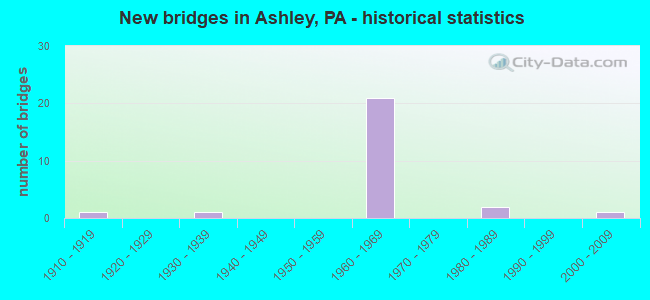
- New bridges - historical statistics
- 11910-1919
- 11930-1939
- 211960-1969
- 21980-1989
- 12000-2009

- Reconstructed bridges - Historical Statistics
- 41970-1979
- 31980-1989
- 31990-1999
- 02000-2009
- 02010-2019
- 12020-2022


- Bridge Condition - Deck
- 6.3%Very good
- 12.5%Good
- 6.3%Satisfactory
- 6.3%Fair
- 56.3%Poor
- 6.3%Serious
- 6.3%Critical

- Bridge Condition - Superstructure
- 6.3%Very good
- 12.5%Good
- 31.3%Satisfactory
- 18.8%Fair
- 18.8%Poor
- 6.3%Serious
- 6.3%Imminent failure

- Bridge Condition - Substructure
- 12.5%Good
- 18.8%Satisfactory
- 50.0%Fair
- 18.8%Poor

- Bridge Condition - Channel
- 16.7%Good
- 50.0%Satisfactory
- 16.7%Fair
- 16.7%Poor
Find on map >> Show street view
Structure Number: 23617, Location: HANOVER TWP .1 M N I-81 (Lat: 41.203056, Lng: -75.904722), Route carried "on" structure: State highway 29, Year Built: 1969, Year Reconstructed: 1990, Status: Open, Structure Length: 2.90m (9.51ft), Average Daily Traffic: 15,719 (year 2022), Truck Traffic: 9%, Average Future Daily Traffic: 29,604 (year 2032), Design Load: HS 20, Features Intersected: HAUL ROAD
Minimum Vertical Clearance: 30+ m (98+ ft), Kilometerpoint: 0.000, Lanes on structure: 2, Lanes under structure: 2, Base Highway Network: Yes, Owner: State Highway Agency, Approaching Roadway Width: 29.0m (95.1ft), Skew: 30 degrees, Material/Design: Prestressed concrete, Design/Construction: Box Beam or Girders - Single/Spread, Number Of Spans In Main Unit: 3, Length of Maximum Span: 9.8m (32.2ft), Curb or Sidewalk Widths: Left: 0.2m (0.7ft), Right: 0.2m (0.7ft), Curb-To-Curb Width: 28.9m (94.8ft), Out-to-Out Width: 30.5m (100.1ft)
Condition: Deck: Good, Superstructure: Good, Substructure: Fair, Operating Rating: 41.7 metric tons, Method Used To Determine Operating Rating: Load Factor (LF), Inventory Rating: 24.5 metric tons, Method Used To Determine Inventory Rating: Load Factor (LF), Structural Evaluation: Somewhat better than minimum adequacy, Deck Geometry: Superior to present desirable criteria, Approach Roadway Alignment: Equal to present desirable criteria, Length Of Structure Improvement: 3.69m (12.11ft), Designated Inspection Frequency: Every 24 months, Inspection Date: November 2020, Deck Structure Type: Concrete Cast-file-Place, Wearing Surface/Protective System: Wearing Surface: Monolithic Concrete, Deck Protection: Epoxy Coated Reinforcing
Find on map >> Show street view
Structure Number: 23729, Location: HANOVER TWP OVR TR29 RAMP (Lat: 41.201794, Lng: -75.905553), Route carried "on" structure: Interstate 81, Year Built: 1967, Year Reconstructed: 2003, Status: Open, Structure Length: 4.72m (15.49ft), Average Daily Traffic: 21,036 (year 2021), Truck Traffic: 28%, Average Future Daily Traffic: 30,064 (year 2032), Design Load: HS 20+Mod, Features Intersected: SR 8011
Minimum Vertical Clearance: 30+ m (98+ ft), Kilometerpoint: 39.076, Lanes on structure: 2, Lanes under structure: 2, Base Highway Network: Yes, Owner: State Highway Agency, Approaching Roadway Width: 11.9m (39.0ft), Skew: 13 degrees, Material/Design: Prestressed concrete, Design/Construction: Box Beam or Girders - Single/Spread, Number Of Spans In Main Unit: 3, Length of Maximum Span: 19.2m (63.0ft), Curb or Sidewalk Widths: Left: 0.2m (0.7ft), Right: 0.2m (0.7ft), Curb-To-Curb Width: 12.4m (40.7ft), Out-to-Out Width: 13.9m (45.6ft)
Condition: Deck: Poor, Superstructure: Poor, Substructure: Fair, Operating Rating: 49.9 metric tons, Method Used To Determine Operating Rating: Load Factor (LF), Inventory Rating: 25.4 metric tons, Method Used To Determine Inventory Rating: Load Factor (LF), Structural Evaluation: Meets minimum limits, Deck Geometry: Better than present minimum criteria, Underclear: Somewhat better than minimum adequacy, Approach Roadway Alignment: Equal to present desirable criteria, Length Of Structure Improvement: 4.80m (15.75ft), Designated Inspection Frequency: Every 24 months, Other Special Inspection Frequency: Every 3 months, Inspection Date: October 2021, Other Special Inspection Date: October 2021, Bridge Improvement Cost: $26,000, Roadway Improvement Cost: $100,000, Total Project Cost: $354,000, Deck Structure Type: Concrete Cast-file-Place, Wearing Surface/Protective System: Wearing Surface: Latex Concrete
Find on map >> Show street view
Structure Number: 23731, Location: HANVR TP OVR SR8011 RMP A (Lat: 41.201856, Lng: -75.905956), Route carried "on" structure: Interstate 81, Year Built: 1967, Year Reconstructed: 2003, Status: Open, Structure Length: 4.72m (15.49ft), Average Daily Traffic: 32,863 (year 2022), Truck Traffic: 16%, Average Future Daily Traffic: 40,041 (year 2032), Design Load: HS 20+Mod, Features Intersected: SR 8011 RAMP A
Minimum Vertical Clearance: 30+ m (98+ ft), Kilometerpoint: 39.371, Lanes on structure: 3, Lanes under structure: 4, Base Highway Network: Yes, Owner: State Highway Agency, Approaching Roadway Width: 15.8m (51.8ft), Skew: 13 degrees, Material/Design: Prestressed concrete, Design/Construction: Box Beam or Girders - Single/Spread, Number Of Spans In Main Unit: 3, Length of Maximum Span: 19.2m (63.0ft), Curb or Sidewalk Widths: Left: 0.2m (0.7ft), Right: 0.2m (0.7ft), Curb-To-Curb Width: 16.1m (52.8ft), Out-to-Out Width: 17.5m (57.4ft)
Condition: Deck: Poor, Superstructure: Fair, Substructure: Fair, Operating Rating: 97.1 metric tons, Method Used To Determine Operating Rating: Load Factor (LF), Inventory Rating: 30.8 metric tons, Method Used To Determine Inventory Rating: Load Factor (LF), Structural Evaluation: Somewhat better than minimum adequacy, Deck Geometry: Equal to present minimum criteria, Underclear: High priority of corrective action, Approach Roadway Alignment: Equal to present desirable criteria, Length Of Structure Improvement: 4.80m (15.75ft), Designated Inspection Frequency: Every 24 months, Inspection Date: October 2021, Bridge Improvement Cost: $51,000, Roadway Improvement Cost: $151,000, Total Project Cost: $693,000, Deck Structure Type: Concrete Cast-file-Place, Wearing Surface/Protective System: Wearing Surface: Latex Concrete
Find on map >> Show street view
Structure Number: 23732, Location: ASHLEY BO .4 M N EXIT 164 (Lat: 41.205475, Lng: -75.900544), Route carried "on" structure: Interstate 81, Year Built: 1967, Status: Open, Structure Length: 0.70m (2.30ft), Average Daily Traffic: 67,105 (year 2022), Truck Traffic: 16%, Average Future Daily Traffic: 78,412 (year 2032), Design Load: HS 20+Mod, Features Intersected: SOLOMON CREEK
Minimum Vertical Clearance: 30+ m (98+ ft), Kilometerpoint: 39.863, Lanes on structure: 3, Base Highway Network: Yes, Owner: State Highway Agency, Approaching Roadway Width: 26.8m (87.9ft), Skew: 23 degrees, Material/Design: Concrete, Design/Construction: Culvert, Number Of Spans In Main Unit: 1, Length of Maximum Span: 7.0m (23.0ft)
Condition: Channel: Satisfactory, Culverts: Satisfactory, Operating Rating: 49.0 metric tons, Method Used To Determine Operating Rating: Field evaluation and documented engineering judgment, Inventory Rating: 32.7 metric tons, Method Used To Determine Inventory Rating: Field evaluation and documented engineering judgment, Structural Evaluation: Equal to present minimum criteria, Waterway Adequacy: Superior to present desirable criteria, Approach Roadway Alignment: Equal to present desirable criteria, Length Of Structure Improvement: 0.70m (2.30ft), Designated Inspection Frequency: Every 24 months, Inspection Date: October 2021, Bridge Improvement Cost: $79,000, Roadway Improvement Cost: $232,000, Total Project Cost: $1,064,000
Find on map >> Show street view
Structure Number: 23735, Location: ASHLEY BORO OVER SR 6309 (Lat: 41.209414, Lng: -75.893325), Route carried "on" structure: Interstate 81, Year Built: 1967, Year Reconstructed: 2020, Status: Open, Structure Length: 8.14m (26.71ft), Average Daily Traffic: 27,674 (year 2022), Truck Traffic: 24%, Average Future Daily Traffic: 35,594 (year 2032), Design Load: HS 20+Mod, Features Intersected: SR 6309
Minimum Vertical Clearance: 30+ m (98+ ft), Kilometerpoint: 40.655, Lanes on structure: 3, Lanes under structure: 4, Base Highway Network: Yes, Owner: State Highway Agency, Approaching Roadway Width: 13.7m (44.9ft), Skew: 5 degrees, Material/Design: Prestressed concrete, Design/Construction: Box Beam or Girders - Single/Spread, Number Of Spans In Main Unit: 4, Length of Maximum Span: 22.3m (73.2ft), Curb or Sidewalk Widths: Left: 0.2m (0.7ft), Right: 0.2m (0.7ft), Curb-To-Curb Width: 14.3m (46.9ft), Out-to-Out Width: 15.8m (51.8ft)
Condition: Deck: Poor, Superstructure: Satisfactory, Substructure: Fair, Operating Rating: 65.3 metric tons, Method Used To Determine Operating Rating: Load Factor (LF), Inventory Rating: 33.6 metric tons, Method Used To Determine Inventory Rating: Load Factor (LF), Structural Evaluation: Somewhat better than minimum adequacy, Deck Geometry: Meets minimum limits, Underclear: High priority of corrective action, Approach Roadway Alignment: Better than present minimum criteria, Length Of Structure Improvement: 8.20m (26.90ft), Designated Inspection Frequency: Every 24 months, Inspection Date: October 2021, Bridge Improvement Cost: $80,000, Roadway Improvement Cost: $235,000, Total Project Cost: $1,077,000, Deck Structure Type: Concrete Cast-file-Place, Wearing Surface/Protective System: Wearing Surface: Latex Concrete
Find on map >> Show street view
Structure Number: 23736, Location: ASHLEY BORO OVER SR 2003 (Lat: 41.210111, Lng: -75.897603), Route carried "on" structure: Interstate 81, Year Built: 1967, Year Reconstructed: 1982, Status: Open, Structure Length: 1.65m (5.41ft), Average Daily Traffic: 32,863 (year 2022), Truck Traffic: 16%, Average Future Daily Traffic: 40,041 (year 2032), Design Load: HS 20+Mod, Features Intersected: SR 2003 HAZELTON STREET
Minimum Vertical Clearance: 30+ m (98+ ft), Kilometerpoint: 40.972, Lanes on structure: 2, Lanes under structure: 2, Base Highway Network: Yes, Owner: State Highway Agency, Approaching Roadway Width: 11.9m (39.0ft), Skew: 3 degrees, Material/Design: Prestressed concrete, Design/Construction: Box Beam or Girders - Single/Spread, Number Of Spans In Main Unit: 1, Length of Maximum Span: 16.5m (54.1ft), Curb or Sidewalk Widths: Left: 0.2m (0.7ft), Right: 0.2m (0.7ft), Curb-To-Curb Width: 12.4m (40.7ft), Out-to-Out Width: 13.9m (45.6ft)
Condition: Deck: Poor, Superstructure: Satisfactory, Substructure: Satisfactory, Operating Rating: 59.9 metric tons, Method Used To Determine Operating Rating: Load Factor (LF), Inventory Rating: 27.2 metric tons, Method Used To Determine Inventory Rating: Load Factor (LF), Structural Evaluation: Equal to present minimum criteria, Deck Geometry: Better than present minimum criteria, Underclear: Meets minimum limits, Approach Roadway Alignment: Better than present minimum criteria, Length Of Structure Improvement: 1.60m (5.25ft), Designated Inspection Frequency: Every 24 months, Inspection Date: October 2021, Bridge Improvement Cost: $13,000, Roadway Improvement Cost: $100,000, Total Project Cost: $171,000, Deck Structure Type: Concrete Cast-file-Place, Wearing Surface/Protective System: Wearing Surface: Latex Concrete, Deck Protection: Epoxy Coated Reinforcing
Find on map >> Show street view
Structure Number: 23737, Location: ASHLEY BORO .7M N EXT 164 (Lat: 41.213614, Lng: -75.892831), Route carried "on" structure: Interstate 81, Year Built: 1966, Year Reconstructed: 1981, Status: Open, Structure Length: 7.62m (25.00ft), Average Daily Traffic: 32,863 (year 2022), Truck Traffic: 16%, Average Future Daily Traffic: 40,041 (year 2032), Design Load: HS 20+Mod, Features Intersected: LUZ CO RAIL AUTHORITY
Minimum Vertical Clearance: 30+ m (98+ ft), Kilometerpoint: 40.972, Lanes on structure: 2, Base Highway Network: Yes, Owner: State Highway Agency, Approaching Roadway Width: 9.8m (32.2ft), Skew: 14 degrees, Material/Design: Steel continuous, Design/Construction: Stringer/Multi-beam, Number Of Spans In Main Unit: 3, Length of Maximum Span: 28.7m (94.2ft), Curb or Sidewalk Widths: Left: 0.2m (0.7ft), Right: 0.2m (0.7ft), Curb-To-Curb Width: 10.0m (32.8ft), Out-to-Out Width: 11.4m (37.4ft)
Condition: Deck: Poor, Superstructure: Fair, Substructure: Satisfactory, Operating Rating: 52.6 metric tons, Method Used To Determine Operating Rating: Load Factor (LF), Inventory Rating: 31.8 metric tons, Method Used To Determine Inventory Rating: Load Factor (LF), Structural Evaluation: Somewhat better than minimum adequacy, Deck Geometry: Meets minimum limits, Underclear: High priority of corrective action, Approach Roadway Alignment: Equal to present desirable criteria, Length Of Structure Improvement: 8.60m (28.22ft), Designated Inspection Frequency: Every 24 months, Other Special Inspection Frequency: Every 6 months, Inspection Date: October 2021, Other Special Inspection Date: October 2021, Bridge Improvement Cost: $21,000, Roadway Improvement Cost: $100,000, Total Project Cost: $281,000, Deck Structure Type: Concrete Cast-file-Place, Wearing Surface/Protective System: Wearing Surface: Latex Concrete
Find on map >> Show street view
Structure Number: 23738, Location: ASHLEY BO .5M N EXIT 165 (Lat: 41.214200, Lng: -75.885994), Route carried "on" structure: Interstate 81, Year Built: 1966, Year Reconstructed: 1981, Status: Open, Structure Length: 7.13m (23.39ft), Average Daily Traffic: 27,674 (year 2022), Truck Traffic: 24%, Average Future Daily Traffic: 35,594 (year 2032), Design Load: HS 20+Mod, Features Intersected: LUZ CO RAIL AUTHORITY
Minimum Vertical Clearance: 30+ m (98+ ft), Kilometerpoint: 41.460, Lanes on structure: 2, Base Highway Network: Yes, Owner: State Highway Agency, Approaching Roadway Width: 11.0m (36.1ft), Skew: 15 degrees, Material/Design: Steel, Design/Construction: Stringer/Multi-beam, Number Of Spans In Main Unit: 3, Length of Maximum Span: 26.8m (87.9ft), Curb or Sidewalk Widths: Left: 0.2m (0.7ft), Right: 0.2m (0.7ft), Curb-To-Curb Width: 10.0m (32.8ft), Out-to-Out Width: 11.4m (37.4ft)
Condition: Deck: Poor, Superstructure: Fair, Substructure: Fair, Operating Rating: 81.6 metric tons, Method Used To Determine Operating Rating: Load Factor (LF), Inventory Rating: 49.0 metric tons, Method Used To Determine Inventory Rating: Load Factor (LF), Structural Evaluation: Somewhat better than minimum adequacy, Deck Geometry: Meets minimum limits, Underclear: High priority of corrective action, Approach Roadway Alignment: Equal to present desirable criteria, Length Of Structure Improvement: 7.10m (23.29ft), Designated Inspection Frequency: Every 24 months, Other Special Inspection Frequency: Every 6 months, Inspection Date: October 2021, Other Special Inspection Date: October 2021, Bridge Improvement Cost: $41,000, Roadway Improvement Cost: $121,000, Total Project Cost: $554,000, Deck Structure Type: Concrete Cast-file-Place, Wearing Surface/Protective System: Wearing Surface: Latex Concrete
Find on map >> Show street view
Structure Number: 24054, Location: ASHLEY BORO .4M W SR2010 (Lat: 41.217414, Lng: -75.905122), Route carried "on" structure: State highway , Year Built: 1984, Status: Open, Structure Length: 1.13m (3.71ft), Average Daily Traffic: 3,602 (year 2021), Truck Traffic: 5%, Average Future Daily Traffic: 5,000 (year 2032), Design Load: HS 20, Features Intersected: SOLOMON CREEK, Facility Carried by Structure: SR 2001
Minimum Vertical Clearance: 30+ m (98+ ft), Kilometerpoint: 0.000, Lanes on structure: 2, Owner: State Highway Agency, Approaching Roadway Width: 11.3m (37.1ft), Skew: 1 degrees, Material/Design: Prestressed concrete, Design/Construction: Box Beam or Girders - Multiple, Number Of Spans In Main Unit: 1, Length of Maximum Span: 11.0m (36.1ft), Curb or Sidewalk Widths: Left: 0.2m (0.7ft), Right: 0.2m (0.7ft), Curb-To-Curb Width: 11.3m (37.1ft), Out-to-Out Width: 12.3m (40.4ft)
Condition: Deck: Poor, Superstructure: Poor, Substructure: Good, Channel: Good, Operating Rating: 81.6 metric tons, Method Used To Determine Operating Rating: Load Factor (LF), Inventory Rating: 44.5 metric tons, Method Used To Determine Inventory Rating: Load Factor (LF), Structural Evaluation: Meets minimum limits, Deck Geometry: Somewhat better than minimum adequacy, Waterway Adequacy: Equal to present desirable criteria, Approach Roadway Alignment: Equal to present desirable criteria, Length Of Structure Improvement: 1.70m (5.58ft), Designated Inspection Frequency: Every 24 months, Inspection Date: December 2020, Deck Structure Type: Other, Wearing Surface/Protective System: Wearing Surface: Bituminous, Membrane: Preformed Fabric
Find on map >> Show street view
Structure Number: 24089, Location: HANOVER TWP .5 M E TR 29 (Lat: 41.204975, Lng: -75.910017), Route carried "on" structure: State highway , Year Built: 1961, Status: Open, Structure Length: 0.94m (3.08ft), Average Daily Traffic: 4,485 (year 2021), Truck Traffic: 3%, Average Future Daily Traffic: 5,308 (year 2032), Design Load: HS 20, Features Intersected: SUGAR NOTCH RUN CREEK, Facility Carried by Structure: SR 2010
Minimum Vertical Clearance: 30+ m (98+ ft), Kilometerpoint: 7.770, Lanes on structure: 2, Owner: State Highway Agency, Approaching Roadway Width: 9.4m (30.8ft), Skew: 3 degrees, Material/Design: Prestressed concrete, Design/Construction: Box Beam or Girders - Multiple, Number Of Spans In Main Unit: 1, Length of Maximum Span: 8.8m (28.9ft), Curb-To-Curb Width: 10.4m (34.1ft), Out-to-Out Width: 12.1m (39.7ft)
Condition: Deck: Poor, Superstructure: Poor, Substructure: Poor, Channel: Poor, Operating Rating: 79.8 metric tons, Method Used To Determine Operating Rating: Load Factor (LF), Inventory Rating: 44.5 metric tons, Method Used To Determine Inventory Rating: Load Factor (LF), Structural Evaluation: Meets minimum limits, Deck Geometry: Somewhat better than minimum adequacy, Waterway Adequacy: Equal to present minimum criteria, Approach Roadway Alignment: Equal to present desirable criteria, Length Of Structure Improvement: 0.90m (2.95ft), Designated Inspection Frequency: Every 24 months, Other Special Inspection Frequency: Every 12 months, Inspection Date: December 2020, Other Special Inspection Date: December 2020, Bridge Improvement Cost: $13,000, Roadway Improvement Cost: $100,000, Total Project Cost: $180,000, Deck Structure Type: Other, Wearing Surface/Protective System: Wearing Surface: Bituminous, Membrane: Preformed Fabric
Find on map >> Show street view
Structure Number: 24093, Location: ASHLEY BORO .1M E SR 2003 (Lat: 41.213311, Lng: -75.899878), Route carried "on" structure: State highway , Year Built: 1917, Year Reconstructed: 1984, Status: Open, Structure Length: 1.37m (4.49ft), Average Daily Traffic: 7,262 (year 2022), Truck Traffic: 3%, Average Future Daily Traffic: 9,106 (year 2032), Design Load: HS 25 or greater, Features Intersected: POCONO NORTHEAST RR, Facility Carried by Structure: SR 2010 MAIN ST
Minimum Vertical Clearance: 30+ m (98+ ft), Kilometerpoint: 8.814, Lanes on structure: 2, Owner: State Highway Agency, Approaching Roadway Width: 9.1m (29.9ft), Skew: 4 degrees, Material/Design: Prestressed concrete, Design/Construction: Box Beam or Girders - Multiple, Number Of Spans In Main Unit: 1, Length of Maximum Span: 13.1m (43.0ft), Curb or Sidewalk Widths: Left: 1.5m (4.9ft), Right: 1.5m (4.9ft), Curb-To-Curb Width: 9.1m (29.9ft), Out-to-Out Width: 12.8m (42.0ft)
Condition: Deck: Satisfactory, Superstructure: Satisfactory, Substructure: Fair, Operating Rating: 78.9 metric tons, Method Used To Determine Operating Rating: Load Factor (LF), Inventory Rating: 28.1 metric tons, Method Used To Determine Inventory Rating: Load Factor (LF), Structural Evaluation: Somewhat better than minimum adequacy, Deck Geometry: High priority of corrective action, Underclear: High priority of corrective action, Approach Roadway Alignment: Somewhat better than minimum adequacy, Length Of Structure Improvement: 1.40m (4.59ft), Designated Inspection Frequency: Every 24 months, Inspection Date: December 2020, Bridge Improvement Cost: $12,000, Roadway Improvement Cost: $100,000, Total Project Cost: $162,000, Deck Structure Type: Concrete Cast-file-Place, Wearing Surface/Protective System: Wearing Surface: Monolithic Concrete, Deck Protection: Epoxy Coated Reinforcing
Find on map >> Show street view
Structure Number: 24366, Location: ASHLEY BO .2 M N SR 2003 (Lat: 41.213497, Lng: -75.888883), Route carried "on" structure: State highway 309B, Year Built: 1966, Year Reconstructed: 1988, Status: Open, Structure Length: 5.15m (16.90ft), Average Daily Traffic: 11,480 (year 2022), Truck Traffic: 5%, Average Future Daily Traffic: 12,593 (year 2032), Design Load: HS 20, Features Intersected: ASHLEY PARK LLC, Facility Carried by Structure: SR 6309 NB
Minimum Vertical Clearance: 30+ m (98+ ft), Kilometerpoint: 0.000, Lanes on structure: 3, Base Highway Network: Yes, Owner: State Highway Agency, Approaching Roadway Width: 14.0m (45.9ft), Skew: 3 degrees, Material/Design: Prestressed concrete, Design/Construction: Box Beam or Girders - Single/Spread, Number Of Spans In Main Unit: 3, Length of Maximum Span: 18.3m (60.0ft), Curb or Sidewalk Widths: Left: 0.2m (0.7ft), Right: 0.2m (0.7ft), Curb-To-Curb Width: 13.4m (44.0ft), Out-to-Out Width: 15.1m (49.5ft)
Condition: Deck: Poor, Superstructure: Satisfactory, Substructure: Fair, Operating Rating: 59.9 metric tons, Method Used To Determine Operating Rating: Load Factor (LF), Inventory Rating: 26.3 metric tons, Method Used To Determine Inventory Rating: Load Factor (LF), Structural Evaluation: Somewhat better than minimum adequacy, Deck Geometry: Somewhat better than minimum adequacy, Approach Roadway Alignment: Equal to present desirable criteria, Length Of Structure Improvement: 5.20m (17.06ft), Designated Inspection Frequency: Every 24 months, Inspection Date: November 2020, Bridge Improvement Cost: $19,000, Roadway Improvement Cost: $100,000, Total Project Cost: $253,000, Deck Structure Type: Concrete Cast-file-Place, Wearing Surface/Protective System: Wearing Surface: Latex Concrete, Deck Protection: Epoxy Coated Reinforcing
Find on map >> Show street view
Structure Number: 24367, Location: ASHLEY BO .7 M S SR 2005 (Lat: 41.213283, Lng: -75.889572), Route carried "on" structure: State highway 309B, Year Built: 1988, Status: Open, Structure Length: 2.04m (6.69ft), Average Daily Traffic: 9,030 (year 2022), Truck Traffic: 4%, Average Future Daily Traffic: 10,925 (year 2032), Design Load: HS 20, Features Intersected: CONRAIL, Facility Carried by Structure: SR 6309 SB
Minimum Vertical Clearance: 30+ m (98+ ft), Kilometerpoint: 0.000, Lanes on structure: 2, Base Highway Network: Yes, Owner: State Highway Agency, Approaching Roadway Width: 11.6m (38.1ft), Skew: 3 degrees, Material/Design: Prestressed concrete, Design/Construction: Box Beam or Girders - Single/Spread, Number Of Spans In Main Unit: 1, Length of Maximum Span: 19.8m (65.0ft), Curb or Sidewalk Widths: Left: 0.2m (0.7ft), Right: 0.2m (0.7ft), Curb-To-Curb Width: 12.2m (40.0ft), Out-to-Out Width: 13.0m (42.7ft)
Condition: Deck: Good, Superstructure: Good, Substructure: Satisfactory, Operating Rating: 70.8 metric tons, Method Used To Determine Operating Rating: Load Factor (LF), Inventory Rating: 42.6 metric tons, Method Used To Determine Inventory Rating: Load Factor (LF), Structural Evaluation: Equal to present minimum criteria, Deck Geometry: Better than present minimum criteria, Approach Roadway Alignment: Equal to present desirable criteria, Length Of Structure Improvement: 2.00m (6.56ft), Designated Inspection Frequency: Every 48 months, Inspection Date: November 2018, Bridge Improvement Cost: $13,000, Roadway Improvement Cost: $100,000, Total Project Cost: $174,000, Deck Structure Type: Concrete Cast-file-Place, Wearing Surface/Protective System: Wearing Surface: Monolithic Concrete, Deck Protection: Epoxy Coated Reinforcing
Find on map >> Show street view
Structure Number: 24368, Location: HANOVER TWP OVER I-81 SB (Lat: 41.216667, Lng: -75.886667), Route carried "on" structure: State highway 309B, Year Built: 1966, Year Reconstructed: 1988, Status: Open, Structure Length: 4.48m (14.70ft), Average Daily Traffic: 20,510 (year 2022), Truck Traffic: 4%, Average Future Daily Traffic: 23,518 (year 2032), Design Load: HS 20, Features Intersected: SR 0081 I-81 SB, Facility Carried by Structure: SR 6309
Minimum Vertical Clearance: 30+ m (98+ ft), Kilometerpoint: 0.938, Lanes on structure: 4, Lanes under structure: 2, Base Highway Network: Yes, Owner: State Highway Agency, Approaching Roadway Width: 19.2m (63.0ft), Skew: 26 degrees, Material/Design: Steel, Design/Construction: Stringer/Multi-beam, Number Of Spans In Main Unit: 1, Length of Maximum Span: 42.4m (139.1ft), Curb or Sidewalk Widths: Left: 0.2m (0.7ft), Right: 0.2m (0.7ft), Curb-To-Curb Width: 20.7m (67.9ft), Out-to-Out Width: 22.4m (73.5ft)
Condition: Deck: Fair, Superstructure: Satisfactory, Substructure: Fair, Operating Rating: 45.4 metric tons, Method Used To Determine Operating Rating: Load Factor (LF), Inventory Rating: 27.2 metric tons, Method Used To Determine Inventory Rating: Load Factor (LF), Structural Evaluation: Somewhat better than minimum adequacy, Deck Geometry: Superior to present desirable criteria, Underclear: High priority of corrective action, Approach Roadway Alignment: Equal to present desirable criteria, Length Of Structure Improvement: 4.20m (13.78ft), Designated Inspection Frequency: Every 24 months, Other Special Inspection Frequency: Every 6 months, Inspection Date: December 2020, Other Special Inspection Date: June 2021, Deck Structure Type: Concrete Cast-file-Place, Wearing Surface/Protective System: Wearing Surface: Latex Concrete
Find on map >> Show street view
Structure Number: 40857, Location: 500 FT SOUTH OF ASHLEY ST (Lat: 41.216506, Lng: -75.904544), Route carried "on" structure: City street , Year Built: 1930, Year Reconstructed: 1980, Status: Closed, Structure Length: 1.58m (5.18ft), Truck Traffic: 1%, Average Future Daily Traffic: 600 (year 2038), Features Intersected: SOLOMON CREEK, Facility Carried by Structure: CAREY STREET
Minimum Vertical Clearance: 30+ m (98+ ft), Kilometerpoint: 0.000, Lanes on structure: 2, Owner: City or Municipal Highway Agency, Approaching Roadway Width: 7.6m (24.9ft), Skew: 5 degrees, Material/Design: Concrete, Design/Construction: Tee Beam, Number Of Spans In Main Unit: 2, Length of Maximum Span: 7.6m (24.9ft), Curb or Sidewalk Widths: Left: 1.8m (5.9ft), Right: 1.8m (5.9ft), Curb-To-Curb Width: 5.5m (18.0ft), Out-to-Out Width: 11.1m (36.4ft)
Condition: Deck: Critical, Superstructure: Serious, Substructure: Poor, Channel: Fair, Operating Rating: 31.8 metric tons, Method Used To Determine Operating Rating: Field evaluation and documented engineering judgment, Inventory Rating: 19.1 metric tons, Method Used To Determine Inventory Rating: Field evaluation and documented engineering judgment, Structural Evaluation: High priority of corrective action, Deck Geometry: Meets minimum limits, Waterway Adequacy: Better than present minimum criteria, Approach Roadway Alignment: Better than present minimum criteria, Bridge Posting: Required (Relationship of Operating Rating to Maximum Legal Load: 30.0 - 39.9% below), Designated Inspection Frequency: Every 24 months, Other Special Inspection Frequency: Every 12 months, Inspection Date: April 2020, Other Special Inspection Date: April 2021, Deck Structure Type: Concrete Cast-file-Place, Wearing Surface/Protective System: Wearing Surface: Bituminous
Find on map >> Show street view
Structure Number: 40858, Location: AT PLANES AVE INTERSECT (Lat: 41.211014, Lng: -75.900858), Route carried "on" structure: City street , Year Built: 1960, Status: Closed, Structure Length: 0.73m (2.40ft), Average Daily Traffic: 110 (year 2012), Truck Traffic: 1%, Average Future Daily Traffic: 150 (year 2032), Features Intersected: SOLOMON CREEK, Facility Carried by Structure: RODGERS AVE
Minimum Vertical Clearance: 30+ m (98+ ft), Kilometerpoint: 0.000, Lanes on structure: 2, Owner: City or Municipal Highway Agency, Approaching Roadway Width: 3.7m (12.1ft), Skew: 3 degrees, Material/Design: Prestressed concrete, Design/Construction: Box Beam or Girders - Multiple, Number Of Spans In Main Unit: 1, Length of Maximum Span: 6.4m (21.0ft), Curb or Sidewalk Widths: Left: 0.2m (0.7ft), Right: 0.2m (0.7ft), Curb-To-Curb Width: 5.2m (17.1ft), Out-to-Out Width: 5.6m (18.4ft)
Condition: Deck: Serious, Superstructure: Imminent failure, Substructure: Poor, Channel: Satisfactory, Operating Rating: 19.1 metric tons, Method Used To Determine Operating Rating: Load Factor (LF), Inventory Rating: 10.9 metric tons, Method Used To Determine Inventory Rating: Load Factor (LF), Waterway Adequacy: Superior to present desirable criteria, Approach Roadway Alignment: Equal to present desirable criteria, Bridge Posting: Required (Relationship of Operating Rating to Maximum Legal Load: > 39.9% below), Designated Inspection Frequency: Every 24 months, Inspection Date: April 2020, Bridge Improvement Cost: $6,000, Roadway Improvement Cost: $18,000, Total Project Cost: $81,000, Deck Structure Type: Other, Wearing Surface/Protective System: Wearing Surface: Bituminous
Find on map >> Show street view
Structure Number: 41253, Location: ASHLEY BO 200' W SR 2003 (Lat: 41.211547, Lng: -75.901197), Route carried "on" structure: State highway , Year Built: 2001, Status: Open, Structure Length: 0.73m (2.40ft), Average Daily Traffic: 4,485 (year 2021), Truck Traffic: 3%, Average Future Daily Traffic: 5,308 (year 2032), Design Load: HL 93, Features Intersected: SOLOMON CREEK, Facility Carried by Structure: SR 2010 S MAIN ST
Minimum Vertical Clearance: 30+ m (98+ ft), Kilometerpoint: 8.814, Lanes on structure: 2, Owner: State Highway Agency, Approaching Roadway Width: 9.4m (30.8ft), Skew: 3 degrees, Material/Design: Prestressed concrete, Design/Construction: Box Beam or Girders - Single/Spread, Number Of Spans In Main Unit: 1, Length of Maximum Span: 7.3m (24.0ft), Curb or Sidewalk Widths: Left: 2.3m (7.5ft), Right: 2.2m (7.2ft), Curb-To-Curb Width: 9.8m (32.2ft), Out-to-Out Width: 14.9m (48.9ft)
Condition: Deck: Very good, Superstructure: Very good, Substructure: Good, Channel: Satisfactory, Operating Rating: 78.9 metric tons, Method Used To Determine Operating Rating: Load Factor (LF), Inventory Rating: 47.2 metric tons, Method Used To Determine Inventory Rating: Load Factor (LF), Structural Evaluation: Better than present minimum criteria, Deck Geometry: Meets minimum limits, Waterway Adequacy: Equal to present desirable criteria, Approach Roadway Alignment: Equal to present desirable criteria, Length Of Structure Improvement: 1.40m (4.59ft), Designated Inspection Frequency: Every 48 months, Inspection Date: December 2018, Deck Structure Type: Concrete Cast-file-Place, Wearing Surface/Protective System: Wearing Surface: Monolithic Concrete, Deck Protection: Epoxy Coated Reinforcing
Find on map >> Show street view
Structure Number: 23617, Location: HANOVER TWP .1 M N I-81 (Lat: 41.203056, Lng: -75.904722), Route carried "under" structure: Other road , Year Built: 1969, Structure Length: 0. m, Features Intersected: HAUL ROAD, Facility Carried by Structure: SR 0029 TR 29
Minimum Vertical Clearance: 4.44m (14.57ft), Kilometerpoint: 0.000, Lanes on structure: 2, Lanes under structure: 2, Material/Design: Prestressed concrete, Design/Construction: Box Beam or Girders - Single/Spread, Length of Maximum Span: 9.8m (32.2ft)
Find on map >> Show street view
Structure Number: 23729, Location: HANOVER TWP OVR TR29 RAMP (Lat: 41.201794, Lng: -75.905553), Route carried "under" structure: Ramp State highway , Year Built: 1967, Structure Length: 0. m, Average Daily Traffic: 1,965 (year 2021), Truck Traffic: 7%, Features Intersected: SR 8011, Facility Carried by Structure: SR 0081 I-81 NB
Minimum Vertical Clearance: 5.41m (17.75ft), Kilometerpoint: 0.000, Lanes on structure: 2, Lanes under structure: 1, Material/Design: Prestressed concrete, Design/Construction: Box Beam or Girders - Single/Spread, Length of Maximum Span: 19.2m (63.0ft)
Find on map >> Show street view
Structure Number: 23729, Location: HANOVER TWP OVR TR29 RAMP (Lat: 41.201794, Lng: -75.905553), Route carried "under" structure: Ramp State highway , Year Built: 1967, Structure Length: 0. m, Average Daily Traffic: 9,363 (year 2021), Truck Traffic: 9%, Features Intersected: SR 8011, Facility Carried by Structure: SR 0081 I-81 NB
Minimum Vertical Clearance: 5.56m (18.24ft), Kilometerpoint: 0.000, Lanes on structure: 2, Lanes under structure: 1, Material/Design: Prestressed concrete, Design/Construction: Box Beam or Girders - Single/Spread, Length of Maximum Span: 19.2m (63.0ft)
Find on map >> Show street view
Structure Number: 23731, Location: HANVR TP OVR SR8011 RMP A (Lat: 41.201856, Lng: -75.905956), Route carried "under" structure: Ramp State highway , Year Built: 1967, Structure Length: 0. m, Average Daily Traffic: 9,363 (year 2021), Truck Traffic: 9%, Features Intersected: SR 8011 RAMP A, Facility Carried by Structure: SR 0081 I-81 SB
Minimum Vertical Clearance: 4.56m (14.96ft), Kilometerpoint: 0.000, Lanes on structure: 3, Lanes under structure: 2, Material/Design: Prestressed concrete, Design/Construction: Box Beam or Girders - Single/Spread, Length of Maximum Span: 19.2m (63.0ft)
Find on map >> Show street view
Structure Number: 23731, Location: HANVR TP OVR SR8011 RMP A (Lat: 41.201856, Lng: -75.905956), Route carried "under" structure: Ramp State highway , Year Built: 1967, Structure Length: 0. m, Average Daily Traffic: 1,965 (year 2021), Truck Traffic: 7%, Features Intersected: SR 8011 RAMP A, Facility Carried by Structure: SR 0081 I-81 SB
Minimum Vertical Clearance: 4.75m (15.58ft), Kilometerpoint: 0.000, Lanes on structure: 3, Lanes under structure: 2, Material/Design: Prestressed concrete, Design/Construction: Box Beam or Girders - Single/Spread, Length of Maximum Span: 19.2m (63.0ft)
Find on map >> Show street view
Structure Number: 23735, Location: ASHLEY BORO OVER SR 6309 (Lat: 41.209414, Lng: -75.893325), Route carried "under" structure: State highway 309B, Year Built: 1967, Structure Length: 0. m, Average Daily Traffic: 5,422 (year 2021), Truck Traffic: 4%, Features Intersected: SR 6309, Facility Carried by Structure: SR 0081 I-81 NB
Minimum Vertical Clearance: 5.13m (16.83ft), Kilometerpoint: 0.000, Lanes on structure: 3, Lanes under structure: 2, Material/Design: Prestressed concrete, Design/Construction: Box Beam or Girders - Single/Spread, Length of Maximum Span: 22.3m (73.2ft)
Find on map >> Show street view
Structure Number: 23735, Location: ASHLEY BORO OVER SR 6309 (Lat: 41.209414, Lng: -75.893325), Route carried "under" structure: State highway 309B, Year Built: 1967, Structure Length: 0. m, Average Daily Traffic: 9,431 (year 2021), Truck Traffic: 5%, Features Intersected: SR 6309, Facility Carried by Structure: SR 0081 I-81 NB
Minimum Vertical Clearance: 5.13m (16.83ft), Kilometerpoint: 0.000, Lanes on structure: 3, Lanes under structure: 2, Material/Design: Prestressed concrete, Design/Construction: Box Beam or Girders - Single/Spread, Length of Maximum Span: 22.3m (73.2ft)
Find on map >> Show street view
Structure Number: 23736, Location: ASHLEY BORO OVER SR 2003 (Lat: 41.210111, Lng: -75.897603), Route carried "under" structure: State highway , Year Built: 1967, Structure Length: 0. m, Average Daily Traffic: 3,771 (year 2022), Truck Traffic: 2%, Features Intersected: SR 2003 HAZELTON STREET, Facility Carried by Structure: SR 0081 I-81 SB
Minimum Vertical Clearance: 4.85m (15.91ft), Kilometerpoint: 0.595, Lanes on structure: 2, Lanes under structure: 2, Material/Design: Prestressed concrete, Design/Construction: Box Beam or Girders - Single/Spread, Length of Maximum Span: 16.5m (54.1ft)
Find on map >> Show street view
Structure Number: 24368, Location: HANOVER TWP OVER I-81 SB (Lat: 41.216667, Lng: -75.886667), Route carried "under" structure: Interstate 81, Year Built: 1966, Structure Length: 0. m, Average Daily Traffic: 31,319 (year 2022), Truck Traffic: 22%, Features Intersected: SR 0081 I-81 SB, Facility Carried by Structure: SR 6309
Minimum Vertical Clearance: 5.16m (16.93ft), Kilometerpoint: 41.772, Lanes on structure: 4, Lanes under structure: 2, Material/Design: Steel, Design/Construction: Stringer/Multi-beam, Length of Maximum Span: 42.4m (139.1ft)