Bridge Statistics for Ashland, Alabama (AL)
Condition, Traffic, Stress, Structural Evaluation, Project Costs
- National Bridge Inventory (NBI) Statistics
- 11Number of bridges
- 69ft / 21.5mTotal length
- $8,321,000Total costs
- 16,074Total average daily traffic
- 1,055Total average daily truck traffic
- 22,686Total future (year 2036) average daily traffic
- National Bridge Inventory (NBI) Registered Bridges for Ashland
- No street view available for this location
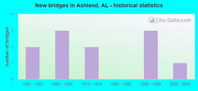
- New bridges - historical statistics
- 21950-1959
- 31960-1969
- 21970-1979
- 31990-1999
- 12000-2009


- Bridge Condition - Deck
- 33.3%Very good
- 66.7%Good

- Bridge Condition - Superstructure
- 33.3%Very good
- 66.7%Good

- Bridge Condition - Substructure
- 33.3%Excellent
- 33.3%Very good
- 33.3%Good

- Bridge Condition - Channel
- 36.4%Very good
- 9.1%Good
- 27.3%Satisfactory
- 27.3%Fair

- Bridge Condition - Culverts
- 12.5%Very good
- 37.5%Satisfactory
- 50.0%Fair
Find on map >> Show street view
Structure Number: 3659, Location: ASHLAND TO HIGHPINE (Lat: 33.256081, Lng: -85.866067), Route carried "on" structure: County highway 10, Year Built: 1950, Status: Open, Structure Length: 1.65m (5.41ft), Average Daily Traffic: 281 (year 2016), Truck Traffic: 6%, Average Future Daily Traffic: 418 (year 2036), Design Load: H 20, Features Intersected: ENITACHOPCO CREEK, Facility Carried by Structure: CO 34
Minimum Vertical Clearance: 0.00m, Kilometerpoint: 0.010, Lanes on structure: 2, Owner: County Highway Agency, Approaching Roadway Width: 8.5m (27.9ft), Material/Design: Concrete, Design/Construction: Culvert, Number Of Spans In Main Unit: 5, Length of Maximum Span: 3.0m (9.8ft), Curb-To-Curb Width: 9.1m (29.9ft), Out-to-Out Width: 9.1m (29.9ft)
Condition: Channel: Good, Culverts: Fair, Operating Rating: 59.4 metric tons, Method Used To Determine Operating Rating: Load Factor (LF), Inventory Rating: 35.7 metric tons, Method Used To Determine Inventory Rating: Load Factor (LF), Structural Evaluation: Somewhat better than minimum adequacy, Deck Geometry: Equal to present minimum criteria, Waterway Adequacy: Equal to present desirable criteria, Approach Roadway Alignment: Equal to present desirable criteria, Length Of Structure Improvement: 2.34m (7.68ft), Designated Inspection Frequency: Every 24 months, Inspection Date: Febuary 2021, Bridge Improvement Cost: $405,000, Roadway Improvement Cost: $41,000, Total Project Cost: $446,000 ( Estimate for 2022), Wearing Surface/Protective System: Wearing Surface: Bituminous
Find on map >> Show street view
Structure Number: 4019, Location: CITY OF ASHLAND (Lat: 33.279722, Lng: -85.818083), Route carried "on" structure: State highway 9, Year Built: 1951, Status: Open, Structure Length: 0.95m (3.12ft), Average Daily Traffic: 5,581 (year 2018), Truck Traffic: 5%, Average Future Daily Traffic: 7,813 (year 2038), Design Load: H 15, Features Intersected: HORSE TROUGH CREEK
Minimum Vertical Clearance: 30+ m (98+ ft), Kilometerpoint: 294.983, Lanes on structure: 2, Base Highway Network: Yes, Owner: State Highway Agency, Approaching Roadway Width: 8.5m (27.9ft), Material/Design: Concrete, Design/Construction: Culvert, Number Of Spans In Main Unit: 3, Length of Maximum Span: 3.0m (9.8ft)
Condition: Channel: Fair, Culverts: Fair, Operating Rating: 55.1 metric tons, Method Used To Determine Operating Rating: Load Factor (LF), Inventory Rating: 33.0 metric tons, Method Used To Determine Inventory Rating: Load Factor (LF), Structural Evaluation: Somewhat better than minimum adequacy, Waterway Adequacy: Equal to present minimum criteria, Approach Roadway Alignment: Somewhat better than minimum adequacy, Length Of Structure Improvement: 1.63m (5.35ft), Designated Inspection Frequency: Every 24 months, Inspection Date: May 2020, Bridge Improvement Cost: $348,000, Roadway Improvement Cost: $35,000, Total Project Cost: $383,000 ( Estimate for 2022)
Find on map >> Show street view
Structure Number: 7626, Location: 0.5 MI N. INTERSECT. 22 (Lat: 33.204064, Lng: -85.845561), Route carried "on" structure: County highway 4, Year Built: 1962, Status: Open, Structure Length: 0.64m (2.10ft), Average Daily Traffic: 879 (year 2016), Truck Traffic: 7%, Average Future Daily Traffic: 1,306 (year 2036), Design Load: H 20, Features Intersected: LYNCH CREEK, Facility Carried by Structure: CO 05
Minimum Vertical Clearance: 30+ m (98+ ft), Kilometerpoint: 0.010, Lanes on structure: 2, Owner: County Highway Agency, Approaching Roadway Width: 9.1m (29.9ft), Material/Design: Concrete, Design/Construction: Culvert, Number Of Spans In Main Unit: 2, Length of Maximum Span: 3.0m (9.8ft)
Condition: Channel: Satisfactory, Culverts: Fair, Operating Rating: 88.9 metric tons, Method Used To Determine Operating Rating: Load Factor (LF), Inventory Rating: 88.9 metric tons, Method Used To Determine Inventory Rating: Load Factor (LF), Structural Evaluation: Somewhat better than minimum adequacy, Waterway Adequacy: Equal to present desirable criteria, Approach Roadway Alignment: Equal to present desirable criteria, Length Of Structure Improvement: 1.26m (4.13ft), Designated Inspection Frequency: Every 24 months, Inspection Date: November 2020, Bridge Improvement Cost: $364,000, Roadway Improvement Cost: $36,000, Total Project Cost: $400,000 ( Estimate for 2022), Wearing Surface/Protective System: Wearing Surface: Bituminous
Find on map >> Show street view
Structure Number: 8437, Location: .4 M S COUNTRY CLUB (Lat: 33.269667, Lng: -85.787167), Route carried "on" structure: County highway 129, Year Built: 1964, Status: Open, Structure Length: 1.04m (3.41ft), Average Daily Traffic: 19 (year 2016), Average Future Daily Traffic: 28 (year 2036), Design Load: H 20, Features Intersected: HORSETROUGH CREEK, Facility Carried by Structure: COUNTRY CLUB ROAD
Minimum Vertical Clearance: 30+ m (98+ ft), Kilometerpoint: 0.010, Lanes on structure: 2, Owner: County Highway Agency, Approaching Roadway Width: 7.9m (25.9ft), Material/Design: Concrete, Design/Construction: Culvert, Number Of Spans In Main Unit: 3, Length of Maximum Span: 3.0m (9.8ft), Curb-To-Curb Width: 11.0m (36.1ft), Out-to-Out Width: 11.0m (36.1ft)
Condition: Channel: Fair, Culverts: Satisfactory, Operating Rating: 66.7 metric tons, Method Used To Determine Operating Rating: Load Factor (LF), Inventory Rating: 40.0 metric tons, Method Used To Determine Inventory Rating: Load Factor (LF), Structural Evaluation: Equal to present minimum criteria, Deck Geometry: Superior to present desirable criteria, Waterway Adequacy: Better than present minimum criteria, Approach Roadway Alignment: Better than present minimum criteria, Length Of Structure Improvement: 1.71m (5.61ft), Designated Inspection Frequency: Every 24 months, Inspection Date: November 2021, Bridge Improvement Cost: $356,000, Roadway Improvement Cost: $36,000, Total Project Cost: $392,000 ( Estimate for 2022), Wearing Surface/Protective System: Wearing Surface: Bituminous
Find on map >> Show street view
Structure Number: 9356, Location: 1.5 M SE HARKINS XROADS (Lat: 33.218464, Lng: -85.847397), Route carried "on" structure: County highway 31, Year Built: 1967, Status: Open, Structure Length: 1.19m (3.90ft), Average Daily Traffic: 260 (year 2016), Truck Traffic: 4%, Average Future Daily Traffic: 390 (year 2036), Design Load: H 20, Features Intersected: ENITACHOPCO CREEK, Facility Carried by Structure: OWENS RD
Minimum Vertical Clearance: 0.00m, Kilometerpoint: 0.010, Lanes on structure: 2, Owner: County Highway Agency, Approaching Roadway Width: 8.5m (27.9ft), Material/Design: Concrete, Design/Construction: Culvert, Number Of Spans In Main Unit: 3, Length of Maximum Span: 3.7m (12.1ft), Curb-To-Curb Width: 15.2m (49.9ft), Out-to-Out Width: 15.2m (49.9ft)
Condition: Channel: Satisfactory, Culverts: Fair, Operating Rating: 75.0 metric tons, Method Used To Determine Operating Rating: Load Factor (LF), Inventory Rating: 45.0 metric tons, Method Used To Determine Inventory Rating: Load Factor (LF), Structural Evaluation: Somewhat better than minimum adequacy, Deck Geometry: Superior to present desirable criteria, Waterway Adequacy: Equal to present desirable criteria, Approach Roadway Alignment: Superior to present desirable criteria, Length Of Structure Improvement: 1.86m (6.10ft), Designated Inspection Frequency: Every 24 months, Inspection Date: March 2020, Bridge Improvement Cost: $538,000, Roadway Improvement Cost: $54,000, Total Project Cost: $592,000 ( Estimate for 2022), Wearing Surface/Protective System: Wearing Surface: Bituminous
Find on map >> Show street view
Structure Number: 10984, Location: 3 MI W ASHLAND (Lat: 33.273300, Lng: -85.867400), Route carried "on" structure: State highway 77, Year Built: 1973, Status: Open, Structure Length: 0.57m (1.87ft), Average Daily Traffic: 2,752 (year 2020), Truck Traffic: 9%, Average Future Daily Traffic: 3,853 (year 2040), Design Load: HS 20, Features Intersected: BRANCH
Minimum Vertical Clearance: 30+ m (98+ ft), Kilometerpoint: 67.681, Lanes on structure: 2, Base Highway Network: Yes, Owner: State Highway Agency, Approaching Roadway Width: 8.5m (27.9ft), Skew: 3 degrees, Material/Design: Concrete, Design/Construction: Culvert, Number Of Spans In Main Unit: 2, Length of Maximum Span: 2.8m (9.2ft)
Condition: Channel: Satisfactory, Culverts: Satisfactory, Operating Rating: 88.9 metric tons, Method Used To Determine Operating Rating: Load Factor (LF), Inventory Rating: 88.9 metric tons, Method Used To Determine Inventory Rating: Load Factor (LF), Structural Evaluation: Equal to present minimum criteria, Waterway Adequacy: Equal to present minimum criteria, Approach Roadway Alignment: Better than present minimum criteria, Length Of Structure Improvement: 1.17m (3.84ft), Designated Inspection Frequency: Every 24 months, Inspection Date: December 2021, Bridge Improvement Cost: $568,000, Roadway Improvement Cost: $57,000, Total Project Cost: $625,000 ( Estimate for 2022)
Find on map >> Show street view
Structure Number: 10985, Location: 4.5 MI N ASHLAND/CO RD130 (Lat: 33.281200, Lng: -85.890400), Route carried "on" structure: State highway 77, Year Built: 1973, Status: Open, Structure Length: 1.27m (4.17ft), Average Daily Traffic: 2,752 (year 2020), Truck Traffic: 9%, Average Future Daily Traffic: 3,853 (year 2040), Design Load: H 20, Features Intersected: TRIB. TO ENITACHOPO CK
Minimum Vertical Clearance: 30+ m (98+ ft), Kilometerpoint: 70.151, Lanes on structure: 2, Base Highway Network: Yes, Owner: State Highway Agency, Approaching Roadway Width: 8.5m (27.9ft), Material/Design: Concrete, Design/Construction: Culvert, Number Of Spans In Main Unit: 4, Length of Maximum Span: 3.0m (9.8ft)
Condition: Channel: Fair, Culverts: Satisfactory, Operating Rating: 88.9 metric tons, Method Used To Determine Operating Rating: Load Factor (LF), Inventory Rating: 65.0 metric tons, Method Used To Determine Inventory Rating: Load Factor (LF), Structural Evaluation: Equal to present minimum criteria, Waterway Adequacy: Equal to present minimum criteria, Approach Roadway Alignment: Equal to present desirable criteria, Length Of Structure Improvement: 1.95m (6.40ft), Designated Inspection Frequency: Every 24 months, Inspection Date: December 2021, Bridge Improvement Cost: $1,045,000, Roadway Improvement Cost: $105,000, Total Project Cost: $1,150,000 ( Estimate for 2022)
Find on map >> Show street view
Structure Number: 16819, Location: 5.5MI N MILLERVILLE (Lat: 33.239975, Lng: -85.859700), Route carried "on" structure: State highway 9, Year Built: 1997, Status: Open, Structure Length: 4.57m (14.99ft), Average Daily Traffic: 2,905 (year 2020), Truck Traffic: 6%, Average Future Daily Traffic: 4,067 (year 2040), Design Load: HS 20, Features Intersected: ENITACHOPCO CREEK
Minimum Vertical Clearance: 30+ m (98+ ft), Kilometerpoint: 290.245, Lanes on structure: 2, Owner: State Highway Agency, Approaching Roadway Width: 8.5m (27.9ft), Material/Design: Prestressed concrete, Design/Construction: Stringer/Multi-beam, Number Of Spans In Main Unit: 3, Length of Maximum Span: 15.2m (49.9ft), Curb-To-Curb Width: 12.0m (39.4ft), Out-to-Out Width: 13.0m (42.7ft)
Condition: Deck: Good, Superstructure: Good, Substructure: Good, Channel: Very good, Operating Rating: 70.7 metric tons, Method Used To Determine Operating Rating: Load Factor (LF), Inventory Rating: 42.3 metric tons, Method Used To Determine Inventory Rating: Load Factor (LF), Structural Evaluation: Better than present minimum criteria, Deck Geometry: Somewhat better than minimum adequacy, Waterway Adequacy: Equal to present minimum criteria, Approach Roadway Alignment: Equal to present desirable criteria, Length Of Structure Improvement: 5.56m (18.24ft), Designated Inspection Frequency: Every 24 months, Inspection Date: December 2021, Bridge Improvement Cost: $1,602,000, Roadway Improvement Cost: $160,000, Total Project Cost: $1,762,000 ( Estimate for 2022), Deck Structure Type: Concrete Cast-file-Place
Find on map >> Show street view
Structure Number: 17695, Location: 6 MILES S OF ASHLAND (Lat: 33.192561, Lng: -85.808078), Route carried "on" structure: County highway , Year Built: 1999, Status: Open, Structure Length: 0.91m (2.99ft), Average Daily Traffic: 33 (year 2016), Average Future Daily Traffic: 49 (year 2036), Features Intersected: CARR CREEK, Facility Carried by Structure: WINDMILL ROAD
Minimum Vertical Clearance: 0.00m, Kilometerpoint: 0.000, Lanes on structure: 2, Owner: County Highway Agency, Approaching Roadway Width: 4.6m (15.1ft), Material/Design: Steel, Design/Construction: Stringer/Multi-beam, Number Of Spans In Main Unit: 1, Length of Maximum Span: 9.1m (29.9ft), Curb-To-Curb Width: 4.8m (15.7ft), Out-to-Out Width: 4.9m (16.1ft)
Condition: Deck: Good, Superstructure: Good, Substructure: Very good, Channel: Very good, Operating Rating: 83.7 metric tons, Method Used To Determine Operating Rating: Load Factor (LF), Inventory Rating: 50.2 metric tons, Method Used To Determine Inventory Rating: Load Factor (LF), Structural Evaluation: Better than present minimum criteria, Waterway Adequacy: Equal to present desirable criteria, Approach Roadway Alignment: Better than present minimum criteria, Length Of Structure Improvement: 1.59m (5.22ft), Designated Inspection Frequency: Every 24 months, Inspection Date: March 2021, Bridge Improvement Cost: $174,000, Roadway Improvement Cost: $17,000, Total Project Cost: $191,000 ( Estimate for 2022), Deck Structure Type: Concrete Cast-file-Place
Find on map >> Show street view
Structure Number: 18145, Location: 2.5 MILES S OF HARKINS (Lat: 33.198403, Lng: -85.842994), Route carried "on" structure: County highway , Year Built: 1998, Status: Open, Structure Length: 7.10m (23.29ft), Average Daily Traffic: 420 (year 2016), Truck Traffic: 5%, Average Future Daily Traffic: 624 (year 2036), Design Load: HS 20, Features Intersected: ENITACHAPCO CREEK, Facility Carried by Structure: NEW PROSPECT ROAD
Minimum Vertical Clearance: 0.00m, Kilometerpoint: 0.000, Lanes on structure: 2, Owner: County Highway Agency, Approaching Roadway Width: 6.6m (21.7ft), Material/Design: Prestressed concrete, Design/Construction: Stringer/Multi-beam, Number Of Spans In Main Unit: 3, Length of Maximum Span: 23.8m (78.1ft), Curb-To-Curb Width: 8.5m (27.9ft), Out-to-Out Width: 8.5m (27.9ft)
Condition: Deck: Very good, Superstructure: Very good, Substructure: Excellent, Channel: Very good, Operating Rating: 80.7 metric tons, Method Used To Determine Operating Rating: Load Factor (LF), Inventory Rating: 47.8 metric tons, Method Used To Determine Inventory Rating: Load Factor (LF), Structural Evaluation: Equal to present desirable criteria, Deck Geometry: High priority of corrective action, Waterway Adequacy: Superior to present desirable criteria, Approach Roadway Alignment: Equal to present desirable criteria, Length Of Structure Improvement: 8.13m (26.67ft), Designated Inspection Frequency: Every 24 months, Inspection Date: April 2021, Bridge Improvement Cost: $1,561,000, Roadway Improvement Cost: $156,000, Total Project Cost: $1,717,000 ( Estimate for 2022), Deck Structure Type: Concrete Cast-file-Place
Find on map >> Show street view
Structure Number: 18693, Location: 4 MI N OF ASHLAND (Lat: 33.289181, Lng: -85.795850), Route carried "on" structure: County highway , Year Built: 2003, Status: Open, Structure Length: 1.58m (5.18ft), Average Daily Traffic: 192 (year 2016), Average Future Daily Traffic: 285 (year 2036), Design Load: HS 20, Features Intersected: OLD TOWN CREEK, Facility Carried by Structure: AIRPORT ROAD
Minimum Vertical Clearance: 0.00m, Kilometerpoint: 0.000, Lanes on structure: 2, Owner: County Highway Agency, Approaching Roadway Width: 9.1m (29.9ft), Skew: 1 degrees, Material/Design: Concrete, Design/Construction: Culvert, Number Of Spans In Main Unit: 4, Length of Maximum Span: 3.7m (12.1ft), Curb-To-Curb Width: 13.5m (44.3ft), Out-to-Out Width: 14.0m (45.9ft)
Condition: Channel: Very good, Culverts: Very good, Operating Rating: 61.1 metric tons, Method Used To Determine Operating Rating: Load Factor (LF), Inventory Rating: 36.7 metric tons, Method Used To Determine Inventory Rating: Load Factor (LF), Structural Evaluation: Equal to present desirable criteria, Deck Geometry: High priority of corrective action, Waterway Adequacy: Superior to present desirable criteria, Approach Roadway Alignment: Superior to present desirable criteria, Length Of Structure Improvement: 2.27m (7.45ft), Designated Inspection Frequency: Every 24 months, Inspection Date: November 2021, Bridge Improvement Cost: $603,000, Roadway Improvement Cost: $60,000, Total Project Cost: $663,000 ( Estimate for 2022), Wearing Surface/Protective System: Wearing Surface: Bituminous