Bridge Statistics for Arroyo Grande, California (CA)
Condition, Traffic, Stress, Structural Evaluation, Project Costs
- National Bridge Inventory (NBI) Statistics
- 27Number of bridges
- 236ft / 72.2mTotal length
- 357,894Total average daily traffic
- 28,290Total average daily truck traffic
- National Bridge Inventory (NBI) Registered Bridges for Arroyo Grande
- No street view available for this location
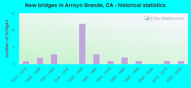
- New bridges - historical statistics
- 11910-1919
- 21920-1929
- 31930-1939
- 121950-1959
- 31960-1969
- 11970-1979
- 21980-1989
- 11990-1999
- 12010-2019
- 12020-2022
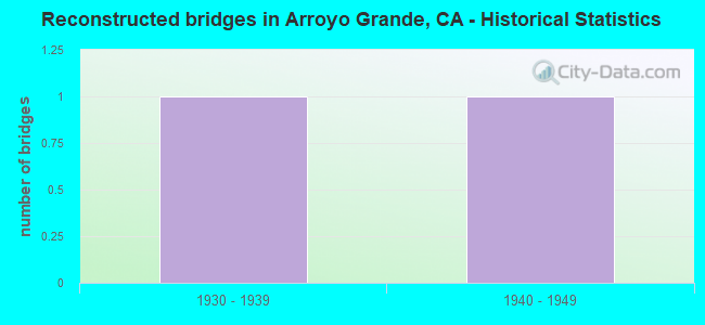
- Reconstructed bridges - Historical Statistics
- 11930-1939
- 11940-1949
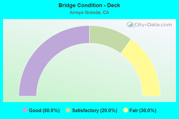
- Bridge Condition - Deck
- 50.0%Good
- 20.0%Satisfactory
- 30.0%Fair
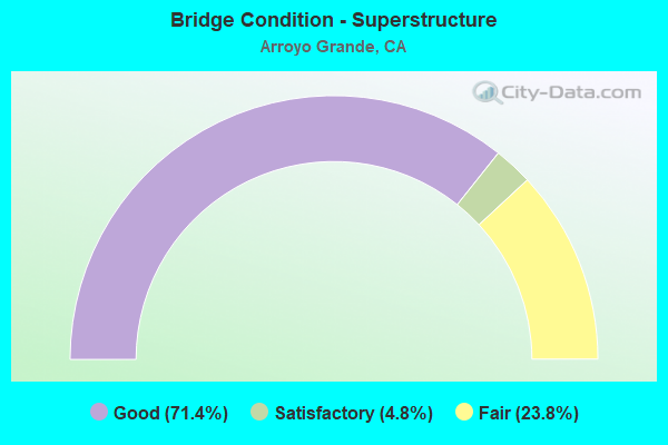
- Bridge Condition - Superstructure
- 71.4%Good
- 4.8%Satisfactory
- 23.8%Fair

- Bridge Condition - Substructure
- 66.7%Good
- 9.5%Satisfactory
- 23.8%Fair
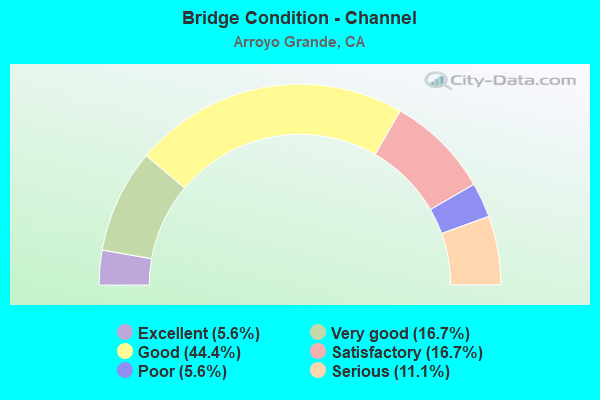
- Bridge Condition - Channel
- 5.6%Excellent
- 16.7%Very good
- 44.4%Good
- 16.7%Satisfactory
- 5.6%Poor
- 11.1%Serious
Find on map >> Show street view
Structure Number: 49 0022, Location: 05-SLO-001-10.35 (Lat: 35.097881, Lng: -120.581631), Route carried "on" structure: State highway 1, Year Built: 1952, Status: Open, Structure Length: 2.74m (8.99ft), Average Daily Traffic: 6,200 (year 2009), Truck Traffic: 6%, Average Future Daily Traffic: 3,860 (year 2039), Design Load: HS 20, Features Intersected: LOS BERROS CREEK
Minimum Vertical Clearance: 30+ m (98+ ft), Kilometerpoint: 10.350, Lanes on structure: 2, Base Highway Network: Yes (, Subroute: 1), Owner: State Highway Agency, Approaching Roadway Width: 6.7m (22.0ft), Skew: 4 degrees, Material/Design: Concrete continuous, Design/Construction: Slab, Number Of Spans In Main Unit: 3, Length of Maximum Span: 11.3m (37.1ft), Curb or Sidewalk Widths: Left: 0.6m (2.0ft), Right: 0.6m (2.0ft), Curb-To-Curb Width: 8.5m (27.9ft), Out-to-Out Width: 9.9m (32.5ft)
Condition: Deck: Fair, Superstructure: Fair, Substructure: Good, Channel: Very good, Operating Rating: 67.1 metric tons, Method Used To Determine Operating Rating: Load Factor (LF), Inventory Rating: 40.5 metric tons, Method Used To Determine Inventory Rating: Load Factor (LF), Structural Evaluation: Somewhat better than minimum adequacy, Deck Geometry: High priority of replacement, Waterway Adequacy: Superior to present desirable criteria, Approach Roadway Alignment: Equal to present minimum criteria, Designated Inspection Frequency: Every 24 months, Inspection Date: September 2021, Deck Structure Type: Concrete Cast-file-Place
Find on map >> Show street view
Structure Number: 49 011, Location: 05-SLO-227-1.43-ARGD (Lat: 35.134206, Lng: -120.570103), Route carried "on" structure: State highway 227, Year Built: 1914, Status: Open, Structure Length: 0.88m (2.89ft), Average Daily Traffic: 3,350 (year 2014), Truck Traffic: 6%, Average Future Daily Traffic: 4,081 (year 2042), Features Intersected: CORBETT CANYON CREEK
Minimum Vertical Clearance: 30+ m (98+ ft), Kilometerpoint: 1.430, Lanes on structure: 2, Base Highway Network: Yes (Inventory Route: 2, Subroute: 1), Owner: State Highway Agency, Approaching Roadway Width: 6.1m (20.0ft), Material/Design: Concrete, Design/Construction: Tee Beam, Number Of Spans In Main Unit: 1, Length of Maximum Span: 8.7m (28.5ft), Curb-To-Curb Width: 6.1m (20.0ft), Out-to-Out Width: 6.9m (22.6ft)
Condition: Deck: Good, Superstructure: Good, Substructure: Fair, Channel: Satisfactory, Operating Rating: 38.6 metric tons, Method Used To Determine Operating Rating: Load Factor (LF), Inventory Rating: 23.3 metric tons, Method Used To Determine Inventory Rating: Load Factor (LF), Structural Evaluation: Somewhat better than minimum adequacy, Deck Geometry: High priority of replacement, Waterway Adequacy: Equal to present minimum criteria, Approach Roadway Alignment: High priority of corrective action, Designated Inspection Frequency: Every 24 months, Inspection Date: May 2020, Deck Structure Type: Concrete Cast-file-Place, Wearing Surface/Protective System: Wearing Surface: Bituminous
Find on map >> Show street view
Structure Number: 49 0151L, Location: 05-SLO-101-45.72-ATAS (Lat: 35.486447, Lng: -120.667222), Route carried "on" structure: US 101, Year Built: 1956, Status: Open, Structure Length: 1.40m (4.59ft), Average Daily Traffic: 30,000 (year 2009), Truck Traffic: 10%, Average Future Daily Traffic: 36,639 (year 2043), Design Load: HS 20, Features Intersected: ATASCADERO CREEK
Minimum Vertical Clearance: 30+ m (98+ ft), Kilometerpoint: 45.720, Lanes on structure: 3, Base Highway Network: Yes (Inventory Route: 1, Subroute: 1), Owner: State Highway Agency, Approaching Roadway Width: 16.9m (55.4ft), Skew: 4 degrees, Material/Design: Concrete, Design/Construction: Tee Beam, Number Of Spans In Main Unit: 1, Length of Maximum Span: 12.5m (41.0ft), Curb-To-Curb Width: 16.9m (55.4ft), Out-to-Out Width: 17.8m (58.4ft)
Condition: Deck: Fair, Superstructure: Good, Substructure: Fair, Channel: Very good, Operating Rating: 39.5 metric tons, Method Used To Determine Operating Rating: Load and Resistance Factor Rating (LRFR) rating reported by rating factor(RF) method using HL-93 loadings, Inventory Rating: 30.5 metric tons, Method Used To Determine Inventory Rating: Load and Resistance Factor Rating (LRFR) rating reported by rating factor(RF) method using HL-93 loadings, Structural Evaluation: Somewhat better than minimum adequacy, Deck Geometry: Equal to present minimum criteria, Waterway Adequacy: Superior to present desirable criteria, Approach Roadway Alignment: Equal to present desirable criteria, Designated Inspection Frequency: Every 24 months, Inspection Date: May 2021, Deck Structure Type: Concrete Cast-file-Place
Find on map >> Show street view
Structure Number: 49 0154, Location: 05-SLO-101-13.75-ARGD (Lat: 35.124319, Lng: -120.593014), Route carried "on" structure: US 101, Year Built: 1956, Status: Open, Structure Length: 1.37m (4.49ft), Average Daily Traffic: 56,000 (year 2009), Truck Traffic: 9%, Average Future Daily Traffic: 105,161 (year 2044), Design Load: HS 20, Features Intersected: BRISCO RD
Minimum Vertical Clearance: 30+ m (98+ ft), Kilometerpoint: 13.750, Lanes on structure: 4, Lanes under structure: 2, Base Highway Network: Yes (Inventory Route: 1, Subroute: 1), Owner: State Highway Agency, Approaching Roadway Width: 31.7m (104.0ft), Skew: 30 degrees, Material/Design: Concrete, Design/Construction: Frame, Number Of Spans In Main Unit: 1, Length of Maximum Span: 12.2m (40.0ft), Curb-To-Curb Width: 31.7m (104.0ft), Out-to-Out Width: 32.6m (107.0ft)
Condition: Deck: Good, Superstructure: Good, Substructure: Good, Operating Rating: 51.8 metric tons, Method Used To Determine Operating Rating: Load Factor (LF), Inventory Rating: 31.1 metric tons, Method Used To Determine Inventory Rating: Load Factor (LF), Structural Evaluation: Better than present minimum criteria, Deck Geometry: Superior to present desirable criteria, Underclear: High priority of corrective action, Approach Roadway Alignment: Equal to present desirable criteria, Designated Inspection Frequency: Every 24 months, Inspection Date: January 2022
Find on map >> Show street view
Structure Number: 49 017, Location: 05-SLO-058-R29.92 (Lat: 35.425383, Lng: -120.226592), Route carried "on" structure: State highway 58, Year Built: 1984, Status: Open, Structure Length: 2.39m (7.84ft), Average Daily Traffic: 495 (year 2009), Truck Traffic: 17%, Average Future Daily Traffic: 1,392 (year 2037), Design Load: HS 20+Mod, Features Intersected: NAVAJO CREEK
Minimum Vertical Clearance: 30+ m (98+ ft), Kilometerpoint: 29.920, Lanes on structure: 2, Base Highway Network: Yes (, Subroute: 1), Owner: State Highway Agency, Approaching Roadway Width: 8.5m (27.9ft), Material/Design: Concrete continuous, Design/Construction: Slab, Number Of Spans In Main Unit: 2, Length of Maximum Span: 11.6m (38.1ft), Curb-To-Curb Width: 9.8m (32.2ft), Out-to-Out Width: 11.0m (36.1ft)
Condition: Deck: Fair, Superstructure: Fair, Substructure: Good, Channel: Good, Operating Rating: 67.7 metric tons, Method Used To Determine Operating Rating: Load Factor (LF), Inventory Rating: 40.8 metric tons, Method Used To Determine Inventory Rating: Load Factor (LF), Structural Evaluation: Somewhat better than minimum adequacy, Deck Geometry: Equal to present minimum criteria, Waterway Adequacy: Superior to present desirable criteria, Approach Roadway Alignment: Equal to present desirable criteria, Designated Inspection Frequency: Every 24 months, Inspection Date: May 2020, Deck Structure Type: Concrete Cast-file-Place
Find on map >> Show street view
Structure Number: 49 0173R, Location: 05-SLO-101-12.52-ARGD (Lat: 35.116736, Lng: -120.573842), Route carried "on" structure: US 101, Year Built: 1959, Status: Open, Structure Length: 6.67m (21.88ft), Average Daily Traffic: 25,500 (year 2009), Truck Traffic: 8%, Average Future Daily Traffic: 51,674 (year 2044), Design Load: HS 20, Features Intersected: BRIDGE ST-S101 ON RAMP
Minimum Vertical Clearance: 30+ m (98+ ft), Kilometerpoint: 12.520, Lanes on structure: 2, Lanes under structure: 1, Base Highway Network: Yes (Inventory Route: 1, Subroute: 1), Owner: State Highway Agency, Approaching Roadway Width: 11.3m (37.1ft), Skew: 6 degrees, Material/Design: Steel, Design/Construction: Stringer/Multi-beam, Number Of Spans In Main Unit: 3, Length of Maximum Span: 22.6m (74.1ft), Curb or Sidewalk Widths: Left: 0.3m (1.0ft), Right: 0.3m (1.0ft), Curb-To-Curb Width: 9.1m (29.9ft), Out-to-Out Width: 9.9m (32.5ft)
Condition: Deck: Good, Superstructure: Good, Substructure: Good, Operating Rating: 67.4 metric tons, Method Used To Determine Operating Rating: Load Factor (LF), Inventory Rating: 40.5 metric tons, Method Used To Determine Inventory Rating: Load Factor (LF), Structural Evaluation: Better than present minimum criteria, Deck Geometry: Meets minimum limits, Underclear: Meets minimum limits, Approach Roadway Alignment: Better than present minimum criteria, Designated Inspection Frequency: Every 24 months, Other Special Inspection Frequency: Every 48 months, Inspection Date: January 2022, Other Special Inspection Date: May 2020, Deck Structure Type: Concrete Cast-file-Place, Wearing Surface/Protective System: Wearing Surface: Integral Concrete
Find on map >> Show street view
Structure Number: 49 0174, Location: 05-SLO-101-12.80-ARGD (Lat: 35.118808, Lng: -120.578011), Route carried "on" structure: City street Z881, Year Built: 1959, Status: Open, Structure Length: 3.84m (12.60ft), Average Daily Traffic: 7,000 (year 2009), Truck Traffic: 8%, Average Future Daily Traffic: 4,532 (year 2044), Design Load: HS 20, Features Intersected: US HIGHWAY 101, Facility Carried by Structure: FAIR OAKS AVE
Minimum Vertical Clearance: 30+ m (98+ ft), Kilometerpoint: 0.000, Lanes on structure: 4, Lanes under structure: 4, Owner: State Highway Agency, Approaching Roadway Width: 14.6m (47.9ft), Skew: 2 degrees, Material/Design: Prestressed concrete continuous, Design/Construction: Slab, Number Of Spans In Main Unit: 2, Length of Maximum Span: 18.9m (62.0ft), Curb or Sidewalk Widths: Left: 2.3m (7.5ft), Right: 2.3m (7.5ft), Curb-To-Curb Width: 14.6m (47.9ft), Out-to-Out Width: 19.7m (64.6ft)
Condition: Deck: Fair, Superstructure: Fair, Substructure: Good, Operating Rating: 84.6 metric tons, Method Used To Determine Operating Rating: Load Factor (LF), Inventory Rating: 32.4 metric tons, Method Used To Determine Inventory Rating: Load Factor (LF), Structural Evaluation: Somewhat better than minimum adequacy, Deck Geometry: High priority of replacement, Underclear: Meets minimum limits, Approach Roadway Alignment: Equal to present desirable criteria, Designated Inspection Frequency: Every 24 months, Inspection Date: January 2022, Deck Structure Type: Concrete Cast-file-Place, Wearing Surface/Protective System: Wearing Surface: Epoxy Overlay
Find on map >> Show street view
Structure Number: 49 0175L, Location: 05-SLO-101-13.02-ARGD (Lat: 35.120511, Lng: -120.581133), Route carried "on" structure: US 101, Year Built: 1959, Status: Open, Structure Length: 5.24m (17.19ft), Average Daily Traffic: 24,000 (year 2012), Truck Traffic: 9%, Average Future Daily Traffic: 47,751 (year 2044), Design Load: HS 20, Features Intersected: ARROYO GRANDE CREEK
Minimum Vertical Clearance: 30+ m (98+ ft), Kilometerpoint: 13.020, Lanes on structure: 3, Base Highway Network: Yes (Inventory Route: 1, Subroute: 1), Owner: State Highway Agency, Approaching Roadway Width: 12.2m (40.0ft), Material/Design: Concrete continuous, Design/Construction: Tee Beam, Number Of Spans In Main Unit: 5, Length of Maximum Span: 11.6m (38.1ft), Curb or Sidewalk Widths: Left: 0.4m (1.3ft), Right: 0.4m (1.3ft), Curb-To-Curb Width: 11.6m (38.1ft), Out-to-Out Width: 13.2m (43.3ft)
Condition: Deck: Good, Superstructure: Good, Substructure: Good, Channel: Satisfactory, Operating Rating: 42.1 metric tons, Method Used To Determine Operating Rating: Load and Resistance Factor Rating (LRFR) rating reported by rating factor(RF) method using HL-93 loadings, Inventory Rating: 32.4 metric tons, Method Used To Determine Inventory Rating: Load and Resistance Factor Rating (LRFR) rating reported by rating factor(RF) method using HL-93 loadings, Structural Evaluation: Better than present minimum criteria, Deck Geometry: High priority of replacement, Waterway Adequacy: Equal to present minimum criteria, Approach Roadway Alignment: Equal to present desirable criteria, Designated Inspection Frequency: Every 24 months, Inspection Date: January 2022, Deck Structure Type: Concrete Cast-file-Place, Wearing Surface/Protective System: Wearing Surface: Bituminous
Find on map >> Show street view
Structure Number: 49 0175R, Location: 05-SLO-101-13.02-ARGD (Lat: 35.120692, Lng: -120.581033), Route carried "on" structure: US 101, Year Built: 1959, Status: Open, Structure Length: 5.24m (17.19ft), Average Daily Traffic: 24,000 (year 2012), Truck Traffic: 8%, Average Future Daily Traffic: 44,805 (year 2044), Design Load: HS 20, Features Intersected: ARROYO GRANDE CREEK
Minimum Vertical Clearance: 30+ m (98+ ft), Kilometerpoint: 13.020, Lanes on structure: 2, Base Highway Network: Yes (Inventory Route: 1, Subroute: 1), Owner: State Highway Agency, Approaching Roadway Width: 11.3m (37.1ft), Material/Design: Concrete continuous, Design/Construction: Tee Beam, Number Of Spans In Main Unit: 5, Length of Maximum Span: 11.6m (38.1ft), Curb or Sidewalk Widths: Left: 0.4m (1.3ft), Right: 0.4m (1.3ft), Curb-To-Curb Width: 10.0m (32.8ft), Out-to-Out Width: 11.7m (38.4ft)
Condition: Deck: Good, Superstructure: Good, Substructure: Good, Channel: Serious, Operating Rating: 25.9 metric tons, Method Used To Determine Operating Rating: Load and Resistance Factor Rating (LRFR) rating reported by rating factor(RF) method using HL-93 loadings, Inventory Rating: 19.8 metric tons, Method Used To Determine Inventory Rating: Load and Resistance Factor Rating (LRFR) rating reported by rating factor(RF) method using HL-93 loadings, Structural Evaluation: Somewhat better than minimum adequacy, Deck Geometry: High priority of replacement, Waterway Adequacy: Equal to present minimum criteria, Approach Roadway Alignment: Equal to present desirable criteria, Designated Inspection Frequency: Every 24 months, Inspection Date: January 2022, Deck Structure Type: Concrete Cast-file-Place, Wearing Surface/Protective System: Wearing Surface: Bituminous
Find on map >> Show street view
Structure Number: 49 0176, Location: 05-SLO-101-13.17-ARGD (Lat: 35.121247, Lng: -120.583833), Route carried "on" structure: City street , Year Built: 1959, Status: Open, Structure Length: 5.18m (16.99ft), Average Daily Traffic: 16,200 (year 2012), Truck Traffic: 6%, Average Future Daily Traffic: 27,661 (year 2044), Design Load: HS 20, Features Intersected: US HWY 101 (@PM 13.17), Facility Carried by Structure: GRAND AVE
Minimum Vertical Clearance: 30+ m (98+ ft), Kilometerpoint: 0.000, Lanes on structure: 4, Lanes under structure: 4, Base Highway Network: Yes, Owner: State Highway Agency, Approaching Roadway Width: 20.0m (65.6ft), Skew: 4 degrees, Material/Design: Concrete continuous, Design/Construction: Box Beam or Girders - Multiple, Number Of Spans In Main Unit: 2, Length of Maximum Span: 24.7m (81.0ft), Curb or Sidewalk Widths: Left: 1.5m (4.9ft), Right: 1.5m (4.9ft), Curb-To-Curb Width: 17.1m (56.1ft), Out-to-Out Width: 20.7m (67.9ft)
Condition: Deck: Good, Superstructure: Good, Substructure: Good, Operating Rating: 53.5 metric tons, Method Used To Determine Operating Rating: Load and Resistance Factor Rating (LRFR) rating reported by rating factor(RF) method using HL-93 loadings, Inventory Rating: 38.6 metric tons, Method Used To Determine Inventory Rating: Load and Resistance Factor Rating (LRFR) rating reported by rating factor(RF) method using HL-93 loadings, Structural Evaluation: Better than present minimum criteria, Deck Geometry: Somewhat better than minimum adequacy, Underclear: High priority of corrective action, Approach Roadway Alignment: Equal to present desirable criteria, Designated Inspection Frequency: Every 24 months, Inspection Date: January 2022, Deck Structure Type: Concrete Cast-file-Place
Find on map >> Show street view
Structure Number: 49C0119, Location: 6.9 MI N OF SR 101 (Lat: 35.173089, Lng: -120.528358), Route carried "on" structure: County highway , Year Built: 1964, Status: Posted for load, Structure Length: 4.15m (13.62ft), Average Daily Traffic: 100 (year 2011), Truck Traffic: 5%, Average Future Daily Traffic: 81 (year 2041), Features Intersected: ARROYO GRANDE CREEK, Facility Carried by Structure: GREIB RANCH WAY
Minimum Vertical Clearance: 30+ m (98+ ft), Kilometerpoint: 0.000, Lanes on structure: 2, Owner: County Highway Agency, Approaching Roadway Width: 7.3m (24.0ft), Material/Design: Steel continuous, Design/Construction: Stringer/Multi-beam, Number Of Spans In Main Unit: 7, Length of Maximum Span: 5.8m (19.0ft), Curb-To-Curb Width: 7.3m (24.0ft), Out-to-Out Width: 7.5m (24.6ft)
Condition: Deck: Fair, Superstructure: Fair, Substructure: Fair, Channel: Good, Operating Rating: 12.3 metric tons, Method Used To Determine Operating Rating: Allowable Stress (AS), Inventory Rating: 5.2 metric tons, Method Used To Determine Inventory Rating: Allowable Stress (AS), Structural Evaluation: High priority of corrective action, Deck Geometry: Equal to present minimum criteria, Waterway Adequacy: Superior to present desirable criteria, Approach Roadway Alignment: Better than present minimum criteria, Bridge Posting: Required (Relationship of Operating Rating to Maximum Legal Load: > 39.9% below), Designated Inspection Frequency: Every 24 months, Inspection Date: July 2021, Deck Structure Type: Concrete Cast-file-Place
Find on map >> Show street view
Structure Number: 49C0124, Location: 0.04 MI SE LOPEZ DR (Lat: 35.139233, Lng: -120.546972), Route carried "on" structure: County highway , Year Built: 1923, Status: Open, Structure Length: 1.37m (4.49ft), Average Daily Traffic: 966 (year 2010), Truck Traffic: 4%, Average Future Daily Traffic: 2,164 (year 2041), Features Intersected: ARROYO GRANDE CREEK, Facility Carried by Structure: HUASNA RD
Minimum Vertical Clearance: 30+ m (98+ ft), Kilometerpoint: 0.000, Lanes on structure: 2, Owner: County Highway Agency, Approaching Roadway Width: 6.0m (19.7ft), Material/Design: Concrete, Design/Construction: Tee Beam, Number Of Spans In Main Unit: 1, Length of Maximum Span: 12.8m (42.0ft), Curb-To-Curb Width: 6.0m (19.7ft), Out-to-Out Width: 6.5m (21.3ft)
Condition: Deck: Good, Superstructure: Good, Substructure: Fair, Channel: Serious, Operating Rating: 26.2 metric tons, Method Used To Determine Operating Rating: Load and Resistance Factor Rating (LRFR) rating reported by rating factor(RF) method using HL-93 loadings, Inventory Rating: 20.4 metric tons, Method Used To Determine Inventory Rating: Load and Resistance Factor Rating (LRFR) rating reported by rating factor(RF) method using HL-93 loadings, Structural Evaluation: Somewhat better than minimum adequacy, Deck Geometry: High priority of replacement, Waterway Adequacy: Better than present minimum criteria, Approach Roadway Alignment: Meets minimum limits, Designated Inspection Frequency: Every 24 months, Inspection Date: July 2021, Deck Structure Type: Concrete Cast-file-Place, Wearing Surface/Protective System: Wearing Surface: Bituminous
Find on map >> Show street view
Structure Number: 49C0191, Location: 2.4 MI E SANTA MARG RD (Lat: 35.349472, Lng: -120.502103), Route carried "on" structure: County highway , Year Built: 1930, Year Reconstructed: 1954, Status: Open, Structure Length: 0.94m (3.08ft), Average Daily Traffic: 189 (year 2006), Truck Traffic: 2%, Average Future Daily Traffic: 575 (year 2040), Design Load: H 10, Features Intersected: PILITAS CREEK, Facility Carried by Structure: LAS PILITAS RD
Minimum Vertical Clearance: 30+ m (98+ ft), Kilometerpoint: 0.000, Lanes on structure: 2, Owner: County Highway Agency, Approaching Roadway Width: 5.5m (18.0ft), Skew: 3 degrees, Material/Design: Steel continuous, Design/Construction: Stringer/Multi-beam, Number Of Spans In Main Unit: 2, Length of Maximum Span: 4.3m (14.1ft), Curb or Sidewalk Widths: Left: 0.1m (0.3ft), Right: 0.1m (0.3ft), Curb-To-Curb Width: 5.5m (18.0ft), Out-to-Out Width: 5.9m (19.4ft)
Condition: Deck: Good, Superstructure: Good, Substructure: Good, Channel: Satisfactory, Operating Rating: 40.2 metric tons, Method Used To Determine Operating Rating: Load Factor (LF), Inventory Rating: 24.0 metric tons, Method Used To Determine Inventory Rating: Load Factor (LF), Structural Evaluation: Equal to present minimum criteria, Deck Geometry: High priority of corrective action, Waterway Adequacy: Equal to present minimum criteria, Approach Roadway Alignment: High priority of corrective action, Designated Inspection Frequency: Every 24 months, Inspection Date: July 2020, Deck Structure Type: Concrete Cast-file-Place, Wearing Surface/Protective System: Wearing Surface: Bituminous
Find on map >> Show street view
Structure Number: 49C0196, Location: 0.1 MI S OF STATE RTE 227 (Lat: 35.122361, Lng: -120.578472), Route carried "on" structure: City street , Year Built: 2021, Status: Open, Structure Length: 4.36m (14.30ft), Average Daily Traffic: 4,000 (year 2021), Truck Traffic: 3%, Average Future Daily Traffic: 6,200 (year 2041), Design Load: HL 93, Features Intersected: ARROYO GRANDE CREEK, Facility Carried by Structure: BRIDGE STREET
Minimum Vertical Clearance: 30+ m (98+ ft), Kilometerpoint: 0.000, Lanes on structure: 2, Owner: City or Municipal Highway Agency, Approaching Roadway Width: 7.3m (24.0ft), Skew: 2 degrees, Material/Design: Steel, Design/Construction: Truss - Deck, Number Of Spans In Main Unit: 1, Number Of Approach Spans: 1, Length of Maximum Span: 30.9m (101.4ft), Curb or Sidewalk Widths: Left: 1.7m (5.6ft), Right: 1.7m (5.6ft), Curb-To-Curb Width: 7.3m (24.0ft), Out-to-Out Width: 8.2m (26.9ft)
Condition: Deck: Good, Superstructure: Good, Substructure: Good, Channel: Very good, Operating Rating: 54.1 metric tons, Method Used To Determine Operating Rating: Field evaluation and documented engineering judgment, Inventory Rating: 32.4 metric tons, Method Used To Determine Inventory Rating: Field evaluation and documented engineering judgment, Structural Evaluation: Better than present minimum criteria, Deck Geometry: High priority of replacement, Waterway Adequacy: Superior to present desirable criteria, Approach Roadway Alignment: Equal to present desirable criteria, Designated Inspection Frequency: Every 24 months, Inspection Date: April 2021, Deck Structure Type: Concrete Cast-file-Place
Find on map >> Show street view
Structure Number: 49C0201, Location: 0.1 MI S OF SR 227 (Lat: 35.123722, Lng: -120.576056), Route carried "on" structure: City street , Year Built: 1926, Status: Open, Structure Length: 5.12m (16.80ft), Average Daily Traffic: 5,546 (year 2010), Truck Traffic: 3%, Average Future Daily Traffic: 4,993 (year 2038), Design Load: HS 20, Features Intersected: ARROYO GRANDE CREEK, Facility Carried by Structure: MASON ST
Minimum Vertical Clearance: 30+ m (98+ ft), Kilometerpoint: 0.000, Lanes on structure: 2, Owner: City or Municipal Highway Agency, Approaching Roadway Width: 6.1m (20.0ft), Material/Design: Concrete, Design/Construction: Arch - Deck, Number Of Spans In Main Unit: 1, Length of Maximum Span: 36.6m (120.1ft), Curb or Sidewalk Widths: Left: 1.4m (4.6ft), Right: 1.4m (4.6ft), Curb-To-Curb Width: 6.1m (20.0ft), Out-to-Out Width: 9.4m (30.8ft)
Condition: Deck: Satisfactory, Superstructure: Good, Substructure: Good, Channel: Poor, Operating Rating: 29.5 metric tons, Method Used To Determine Operating Rating: Load Factor (LF), Inventory Rating: 17.5 metric tons, Method Used To Determine Inventory Rating: Load Factor (LF), Structural Evaluation: Meets minimum limits, Deck Geometry: High priority of replacement, Waterway Adequacy: Superior to present desirable criteria, Approach Roadway Alignment: Better than present minimum criteria, Designated Inspection Frequency: Every 24 months, Inspection Date: April 2021, Deck Structure Type: Concrete Cast-file-Place, Wearing Surface/Protective System: Wearing Surface: Bituminous
Find on map >> Show street view
Structure Number: 49C031, Location: AT ASUNCION RD (Lat: 35.428617, Lng: -120.605603), Route carried "on" structure: County highway , Year Built: 1930, Year Reconstructed: 1937, Status: Open, Structure Length: 2.47m (8.10ft), Average Daily Traffic: 5,046 (year 2006), Truck Traffic: 3%, Average Future Daily Traffic: 8,832 (year 2040), Design Load: H 15, Features Intersected: SANTA MARGARITA CREEK, Facility Carried by Structure: EL CAMINO REAL
Minimum Vertical Clearance: 30+ m (98+ ft), Kilometerpoint: 0.000, Lanes on structure: 2, Owner: County Highway Agency, Approaching Roadway Width: 10.2m (33.5ft), Material/Design: Steel, Design/Construction: Stringer/Multi-beam, Number Of Spans In Main Unit: 5, Length of Maximum Span: 4.9m (16.1ft), Curb or Sidewalk Widths: Left: 0.3m (1.0ft), Right: 0.3m (1.0ft), Curb-To-Curb Width: 10.2m (33.5ft), Out-to-Out Width: 11.6m (38.1ft)
Condition: Deck: Satisfactory, Superstructure: Fair, Substructure: Fair, Channel: Good, Operating Rating: 33.7 metric tons, Method Used To Determine Operating Rating: Load Factor (LF), Inventory Rating: 20.1 metric tons, Method Used To Determine Inventory Rating: Load Factor (LF), Structural Evaluation: Somewhat better than minimum adequacy, Deck Geometry: Meets minimum limits, Waterway Adequacy: Superior to present desirable criteria, Approach Roadway Alignment: Equal to present desirable criteria, Designated Inspection Frequency: Every 24 months, Critical Feature Inspection Frequency: Every 24 months, Inspection Date: July 2020, Critical Feature Inspection Date: October 2020, Deck Structure Type: Concrete Cast-file-Place, Wearing Surface/Protective System: Wearing Surface: Bituminous
Find on map >> Show street view
Structure Number: 49C0318, Location: ARROYO GRANDE (Lat: 35.122186, Lng: -120.580522), Route carried "on" structure: City street , Year Built: 1932, Status: Open, Structure Length: 6.95m (22.80ft), Average Daily Traffic: 9,600 (year 2010), Truck Traffic: 4%, Average Future Daily Traffic: 10,304 (year 2040), Design Load: H 15, Features Intersected: ARROYO GRANDE CREEK, Facility Carried by Structure: TRAFFIC WAY
Minimum Vertical Clearance: 30+ m (98+ ft), Kilometerpoint: 0.000, Lanes on structure: 3, Owner: City or Municipal Highway Agency, Approaching Roadway Width: 12.2m (40.0ft), Skew: 3 degrees, Material/Design: Concrete, Design/Construction: Tee Beam, Number Of Spans In Main Unit: 6, Length of Maximum Span: 11.3m (37.1ft), Curb or Sidewalk Widths: Left: 1.2m (3.9ft), Right: 1.2m (3.9ft), Curb-To-Curb Width: 12.2m (40.0ft), Out-to-Out Width: 15.9m (52.2ft)
Condition: Deck: Fair, Superstructure: Good, Substructure: Satisfactory, Channel: Good, Operating Rating: 35.0 metric tons, Method Used To Determine Operating Rating: Load and Resistance Factor Rating (LRFR) rating reported by rating factor(RF) method using HL-93 loadings, Inventory Rating: 26.9 metric tons, Method Used To Determine Inventory Rating: Load and Resistance Factor Rating (LRFR) rating reported by rating factor(RF) method using HL-93 loadings, Structural Evaluation: Equal to present minimum criteria, Deck Geometry: Meets minimum limits, Waterway Adequacy: Superior to present desirable criteria, Approach Roadway Alignment: Equal to present minimum criteria, Designated Inspection Frequency: Every 24 months, Inspection Date: September 2020, Deck Structure Type: Concrete Cast-file-Place
Find on map >> Show street view
Structure Number: 49C0352, Location: 0.4 MI N SR 1 (Lat: 35.103494, Lng: -120.581492), Route carried "on" structure: County highway , Year Built: 1962, Status: Open, Structure Length: 2.80m (9.19ft), Average Daily Traffic: 5,167 (year 2010), Truck Traffic: 3%, Average Future Daily Traffic: 7,728 (year 2040), Design Load: H 20, Features Intersected: LOS BERROS CRK DIV CHNL, Facility Carried by Structure: VALLEY RD
Minimum Vertical Clearance: 30+ m (98+ ft), Kilometerpoint: 0.000, Lanes on structure: 2, Owner: County Highway Agency, Approaching Roadway Width: 8.5m (27.9ft), Material/Design: Concrete continuous, Design/Construction: Slab, Number Of Spans In Main Unit: 3, Length of Maximum Span: 11.0m (36.1ft), Curb or Sidewalk Widths: Left: 0.3m (1.0ft), Right: 0.3m (1.0ft), Curb-To-Curb Width: 8.5m (27.9ft), Out-to-Out Width: 9.1m (29.9ft)
Condition: Deck: Satisfactory, Superstructure: Satisfactory, Substructure: Good, Channel: Good, Operating Rating: 41.1 metric tons, Method Used To Determine Operating Rating: Load and Resistance Factor Rating (LRFR) rating reported by rating factor(RF) method using HL-93 loadings, Inventory Rating: 29.8 metric tons, Method Used To Determine Inventory Rating: Load and Resistance Factor Rating (LRFR) rating reported by rating factor(RF) method using HL-93 loadings, Structural Evaluation: Equal to present minimum criteria, Deck Geometry: High priority of replacement, Waterway Adequacy: Equal to present desirable criteria, Approach Roadway Alignment: Better than present minimum criteria, Designated Inspection Frequency: Every 24 months, Inspection Date: September 2020, Deck Structure Type: Concrete Cast-file-Place
Find on map >> Show street view
Structure Number: 49C04, Location: ARROYO GRANDE (Lat: 35.112633, Lng: -120.587828), Route carried "on" structure: City street , Year Built: 1977, Status: Open, Structure Length: 3.08m (10.10ft), Average Daily Traffic: 8,945 (year 2010), Truck Traffic: 3%, Average Future Daily Traffic: 9,461 (year 2040), Features Intersected: ARROYO GRANDE CREEK, Facility Carried by Structure: FAIR OAKS BLVD
Minimum Vertical Clearance: 30+ m (98+ ft), Kilometerpoint: 0.000, Lanes on structure: 2, Owner: City or Municipal Highway Agency, Approaching Roadway Width: 19.5m (64.0ft), Skew: 2 degrees, Material/Design: Prestressed concrete, Design/Construction: Stringer/Multi-beam, Number Of Spans In Main Unit: 1, Length of Maximum Span: 30.3m (99.4ft), Curb or Sidewalk Widths: Left: 1.6m (5.2ft), Right: 1.6m (5.2ft), Curb-To-Curb Width: 19.5m (64.0ft), Out-to-Out Width: 22.9m (75.1ft)
Condition: Deck: Satisfactory, Superstructure: Good, Substructure: Satisfactory, Channel: Good, Operating Rating: 54.1 metric tons, Method Used To Determine Operating Rating: Load and Resistance Factor Rating (LRFR) rating reported by rating factor(RF) method using HL-93 loadings, Inventory Rating: 26.2 metric tons, Method Used To Determine Inventory Rating: Load and Resistance Factor Rating (LRFR) rating reported by rating factor(RF) method using HL-93 loadings, Structural Evaluation: Equal to present minimum criteria, Deck Geometry: Superior to present desirable criteria, Waterway Adequacy: Superior to present desirable criteria, Approach Roadway Alignment: Equal to present desirable criteria, Designated Inspection Frequency: Every 24 months, Inspection Date: September 2020, Deck Structure Type: Concrete Cast-file-Place
Find on map >> Show street view
Structure Number: 49C0425, Location: JEO LOS BANOS RD (Lat: 35.102947, Lng: -120.578661), Route carried "on" structure: County highway , Year Built: 1996, Status: Open, Structure Length: 2.00m (6.56ft), Average Daily Traffic: 250 (year 2001), Truck Traffic: 1%, Average Future Daily Traffic: 312 (year 2036), Features Intersected: LOS BERROS CREEK, Facility Carried by Structure: CENTURY LANE
Minimum Vertical Clearance: 30+ m (98+ ft), Kilometerpoint: 0.000, Lanes on structure: 2, Owner: County Highway Agency, Approaching Roadway Width: 9.5m (31.2ft), Material/Design: Concrete continuous, Design/Construction: Culvert, Number Of Spans In Main Unit: 6, Length of Maximum Span: 3.0m (9.8ft)
Condition: Channel: Good, Culverts: Good, Operating Rating: 54.1 metric tons, Method Used To Determine Operating Rating: Field evaluation and documented engineering judgment, Inventory Rating: 32.4 metric tons, Method Used To Determine Inventory Rating: Field evaluation and documented engineering judgment, Structural Evaluation: Better than present minimum criteria, Waterway Adequacy: Equal to present desirable criteria, Approach Roadway Alignment: Equal to present desirable criteria, Designated Inspection Frequency: Every 48 months, Inspection Date: December 2018
Find on map >> Show street view
Structure Number: 49C0459, Location: 0.2 MI S OF HUASNA ROAD (Lat: 35.131722, Lng: -120.542806), Route carried "on" structure: County highway , Year Built: 2015, Status: Open, Structure Length: 3.27m (10.73ft), Average Daily Traffic: 1,240 (year 2010), Truck Traffic: 5%, Average Future Daily Traffic: 1,500 (year 2039), Design Load: HL 93, Features Intersected: TAR SPRING CREEK, Facility Carried by Structure: BRANCH MILL ROAD
Minimum Vertical Clearance: 30+ m (98+ ft), Kilometerpoint: 0.000, Lanes on structure: 2, Owner: County Highway Agency, Approaching Roadway Width: 9.8m (32.2ft), Skew: 2 degrees, Material/Design: Prestressed concrete, Design/Construction: Stringer/Multi-beam, Number Of Spans In Main Unit: 1, Length of Maximum Span: 30.3m (99.4ft), Curb-To-Curb Width: 9.8m (32.2ft), Out-to-Out Width: 10.6m (34.8ft)
Condition: Deck: Good, Superstructure: Good, Substructure: Good, Channel: Good, Operating Rating: 42.1 metric tons, Method Used To Determine Operating Rating: Assigned ratings based on Load and Resistance Factor Design (LRFD) reported by rating factor (RF) using HL93 loadings, Inventory Rating: 32.4 metric tons, Method Used To Determine Inventory Rating: Assigned ratings based on Load and Resistance Factor Design (LRFD) reported by rating factor (RF) using HL93 loadings, Structural Evaluation: Better than present minimum criteria, Deck Geometry: Somewhat better than minimum adequacy, Waterway Adequacy: Equal to present desirable criteria, Approach Roadway Alignment: Equal to present desirable criteria, Designated Inspection Frequency: Every 48 months, Inspection Date: July 2019, Deck Structure Type: Concrete Cast-file-Place
Find on map >> Show street view
Structure Number: 49C046, Location: JEO ALYSSUM CT (Lat: 35.248239, Lng: -120.639050), Route carried "on" structure: City street , Year Built: 1986, Status: Open, Structure Length: 0.75m (2.46ft), Average Daily Traffic: 1,100 (year 2004), Truck Traffic: 5%, Average Future Daily Traffic: 2,000 (year 2041), Features Intersected: E FK SAN LUIS OBISPO CRK, Facility Carried by Structure: POINSETTIA STREET
Minimum Vertical Clearance: 30+ m (98+ ft), Kilometerpoint: 0.000, Lanes on structure: 2, Owner: City or Municipal Highway Agency, Approaching Roadway Width: 12.2m (40.0ft), Skew: 2 degrees, Material/Design: Steel, Design/Construction: Arch - Deck, Number Of Spans In Main Unit: 1, Length of Maximum Span: 7.5m (24.6ft), Curb or Sidewalk Widths: Left: 2.0m (6.6ft), Right: 2.0m (6.6ft), Curb-To-Curb Width: 12.2m (40.0ft), Out-to-Out Width: 16.8m (55.1ft)
Condition: Superstructure: Good, Substructure: Good, Channel: Excellent, Operating Rating: 54.1 metric tons, Method Used To Determine Operating Rating: Field evaluation and documented engineering judgment, Inventory Rating: 32.4 metric tons, Method Used To Determine Inventory Rating: Field evaluation and documented engineering judgment, Structural Evaluation: Better than present minimum criteria, Deck Geometry: Better than present minimum criteria, Waterway Adequacy: Equal to present desirable criteria, Approach Roadway Alignment: Equal to present desirable criteria, Designated Inspection Frequency: Every 24 months, Inspection Date: Febuary 2021
Find on map >> Show street view
Structure Number: 49 0154, Location: 05-SLO-101-13.75-ARGD (Lat: 35.124319, Lng: -120.593014), Route carried "under" structure: ServiceCity street , Year Built: 1956, Structure Length: 0. m, Average Daily Traffic: 8,000 (year 2009), Truck Traffic: 8%, Features Intersected: BRISCO RD, Facility Carried by Structure: U.S. HIGHWAY 101
Minimum Vertical Clearance: 4.44m (14.57ft), Kilometerpoint: 0.000, Lanes on structure: 4, Lanes under structure: 2, Material/Design: Concrete, Design/Construction: Frame, Length of Maximum Span: 12.2m (40.0ft)
Find on map >> Show street view
Structure Number: 49 0173R, Location: 05-SLO-101-12.52-ARGD (Lat: 35.116736, Lng: -120.573842), Route carried "under" structure: Ramp US 101, Year Built: 1959, Structure Length: 0. m, Average Daily Traffic: 2,800 (year 2014), Truck Traffic: 10%, Features Intersected: BRIDGE ST-S101 ON RAMP
Minimum Vertical Clearance: 4.59m (15.06ft), Kilometerpoint: 12.520, Lanes on structure: 2, Lanes under structure: 1, Material/Design: Steel, Design/Construction: Stringer/Multi-beam, Length of Maximum Span: 22.6m (74.1ft)
Find on map >> Show street view
Structure Number: 49 0174, Location: 05-SLO-101-12.80-ARGD (Lat: 35.118808, Lng: -120.578011), Route carried "under" structure: US 101, Year Built: 1959, Structure Length: 0. m, Average Daily Traffic: 48,000 (year 2009), Truck Traffic: 9%, Features Intersected: US HIGHWAY 101, Facility Carried by Structure: FAIR OAKS AVE
Minimum Vertical Clearance: 4.67m (15.32ft), Kilometerpoint: 12.800, Lanes on structure: 4, Lanes under structure: 4, Material/Design: Prestressed concrete continuous, Design/Construction: Slab, Length of Maximum Span: 18.9m (62.0ft)
Find on map >> Show street view
Structure Number: 49 0176, Location: 05-SLO-101-13.17-ARGD (Lat: 35.121247, Lng: -120.583833), Route carried "under" structure: US 101, Year Built: 1959, Structure Length: 0. m, Average Daily Traffic: 48,000 (year 2009), Truck Traffic: 9%, Features Intersected: US HWY 101 (@PM 13.17), Facility Carried by Structure: GRAND AVE
Minimum Vertical Clearance: 4.57m (14.99ft), Kilometerpoint: 13.170, Lanes on structure: 4, Lanes under structure: 4, Material/Design: Concrete continuous, Design/Construction: Box Beam or Girders - Multiple, Length of Maximum Span: 24.7m (81.0ft)
Find on map >> Show street view
Structure Number: 49C0469, Location: .06 MI SW OF HUASNA RD (Lat: 35.126564, Lng: -120.570575), Route carried "under" structure: State highway 227, Year Built: 1963, Structure Length: 0. m, Average Daily Traffic: 16,200 (year 2006), Truck Traffic: 6%, Features Intersected: STATE ROUTE 227, Facility Carried by Structure: PEDESTRIAN WALKWAY
Minimum Vertical Clearance: 5.08m (16.67ft), Kilometerpoint: 0.870, Lanes under structure: 2, Material/Design: Concrete continuous, Design/Construction: Stringer/Multi-beam, Length of Maximum Span: 20.1m (65.9ft)