Bridge Statistics for Argentine, Michigan (MI)
Condition, Traffic, Stress, Structural Evaluation, Project Costs
- National Bridge Inventory (NBI) Statistics
- 24Number of bridges
- 187ft / 56.8mTotal length
- $425,000Total costs
- 146,035Total average daily traffic
- 7,224Total average daily truck traffic
- 154,833Total future (year 1977) average daily traffic
- National Bridge Inventory (NBI) Registered Bridges for Argentine
- No street view available for this location
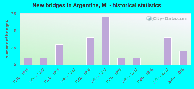
- New bridges - historical statistics
- 11910-1919
- 11920-1929
- 31930-1939
- 41950-1959
- 71960-1969
- 11970-1979
- 11980-1989
- 42000-2009
- 22010-2019

- Reconstructed bridges - Historical Statistics
- 11970-1979
- 01980-1989
- 21990-1999
- 12000-2009
- 12010-2019


- Bridge Condition - Deck
- 4.3%Excellent
- 8.7%Very good
- 34.8%Good
- 34.8%Satisfactory
- 13.0%Fair
- 4.3%Poor

- Bridge Condition - Superstructure
- 4.3%Excellent
- 26.1%Very good
- 17.4%Good
- 43.5%Satisfactory
- 4.3%Poor
- 4.3%Critical

- Bridge Condition - Substructure
- 4.3%Excellent
- 21.7%Very good
- 39.1%Good
- 21.7%Satisfactory
- 8.7%Fair
- 4.3%Poor

- Bridge Condition - Channel
- 9.5%Very good
- 38.1%Good
- 23.8%Satisfactory
- 19.0%Fair
- 9.5%Poor
Find on map >> Show street view
Structure Number: 613, Location: 5.0 MI NW OF KAWKAWLIN (Lat: 43.698150, Lng: -84.012389), Route carried "on" structure: Interstate 75, Year Built: 1968, Year Reconstructed: 2021, Status: Open, Structure Length: 4.11m (13.48ft), Average Daily Traffic: 11,638 (year 2021), Truck Traffic: 7%, Average Future Daily Traffic: 12,863 (year 2041), Design Load: HS 20, Features Intersected: N BR KAWKAWLIN RIVER
Minimum Vertical Clearance: 30.48m (100.00ft), Kilometerpoint: 21.680, Lanes on structure: 2, Base Highway Network: Yes (Inventory Route: 76, Subroute: 1), Owner: State Highway Agency, Approaching Roadway Width: 12.2m (40.0ft), Skew: 1 degrees, Material/Design: Steel continuous, Design/Construction: Stringer/Multi-beam, Number Of Spans In Main Unit: 3, Length of Maximum Span: 16.0m (52.5ft), Curb-To-Curb Width: 12.8m (42.0ft), Out-to-Out Width: 13.4m (44.0ft)
Condition: Deck: Fair, Superstructure: Very good, Substructure: Good, Channel: Very good, Operating Rating: 62.9 metric tons, Method Used To Determine Operating Rating: Load Factor (LF) rating reported by rating factor (RF) method using MS18 loading, Inventory Rating: 37.6 metric tons, Method Used To Determine Inventory Rating: Load Factor (LF) rating reported by rating factor (RF) method using MS18 loading, Structural Evaluation: Better than present minimum criteria, Deck Geometry: Equal to present desirable criteria, Waterway Adequacy: Equal to present desirable criteria, Approach Roadway Alignment: Better than present minimum criteria, Designated Inspection Frequency: Every 24 months, Underwater Inspection Frequency: Every 60 months, Inspection Date: June 2020, Underwater Inspection Date: September 2020, Deck Structure Type: Concrete Cast-file-Place, Wearing Surface/Protective System: Wearing Surface: Monolithic Concrete, Deck Protection: Epoxy Coated Reinforcing
Find on map >> Show street view
Structure Number: 652, Location: 2.0 MI E OF AUBURN (Lat: 43.596597, Lng: -84.025633), Route carried "on" structure: US 10, Year Built: 1956, Status: Open, Structure Length: 1.06m (3.48ft), Average Daily Traffic: 33,474 (year 2007), Truck Traffic: 6%, Average Future Daily Traffic: 38,748 (year 2018), Design Load: HS 20, Features Intersected: CULVER DRAIN
Minimum Vertical Clearance: 30.48m (100.00ft), Kilometerpoint: 12.228, Lanes on structure: 4, Base Highway Network: Yes (Inventory Route: 76, Subroute: 7), Owner: State Highway Agency, Approaching Roadway Width: 19.5m (64.0ft), Skew: 14 degrees, Material/Design: Concrete, Design/Construction: Tee Beam, Number Of Spans In Main Unit: 1, Length of Maximum Span: 10.6m (34.8ft), Curb-To-Curb Width: 32.3m (106.0ft), Out-to-Out Width: 33.3m (109.3ft)
Condition: Deck: Satisfactory, Superstructure: Satisfactory, Substructure: Satisfactory, Channel: Fair, Operating Rating: 73.6 metric tons, Method Used To Determine Operating Rating: Load Factor (LF), Inventory Rating: 44.1 metric tons, Method Used To Determine Inventory Rating: Load Factor (LF), Structural Evaluation: Equal to present minimum criteria, Deck Geometry: Superior to present desirable criteria, Waterway Adequacy: Equal to present desirable criteria, Approach Roadway Alignment: Equal to present minimum criteria, Designated Inspection Frequency: Every 24 months, Inspection Date: August 2021, Deck Structure Type: Concrete Cast-file-Place, Wearing Surface/Protective System: Wearing Surface: Bituminous
Find on map >> Show street view
Structure Number: 657, Location: 0.3 MI E OF MIDLAND COL (Lat: 43.608531, Lng: -84.163503), Route carried "on" structure: US 10, Year Built: 1961, Year Reconstructed: 1997, Status: Open, Structure Length: 4.69m (15.39ft), Average Daily Traffic: 35,800 (year 2014), Truck Traffic: 6%, Average Future Daily Traffic: 24,217 (year 2018), Design Load: HS 20, Features Intersected: GTW RR
Minimum Vertical Clearance: 30.48m (100.00ft), Kilometerpoint: 0.681, Lanes on structure: 2, Base Highway Network: Yes (Inventory Route: 76, Subroute: 8), Owner: State Highway Agency, Approaching Roadway Width: 13.4m (44.0ft), Skew: 3 degrees, Material/Design: Steel, Design/Construction: Stringer/Multi-beam, Number Of Spans In Main Unit: 3, Length of Maximum Span: 15.5m (50.9ft), Curb-To-Curb Width: 13.5m (44.3ft), Out-to-Out Width: 14.4m (47.2ft)
Condition: Deck: Satisfactory, Superstructure: Satisfactory, Substructure: Satisfactory, Operating Rating: 84.6 metric tons, Method Used To Determine Operating Rating: Load Factor (LF) rating reported by rating factor (RF) method using MS18 loading, Inventory Rating: 50.5 metric tons, Method Used To Determine Inventory Rating: Load Factor (LF) rating reported by rating factor (RF) method using MS18 loading, Structural Evaluation: Equal to present minimum criteria, Deck Geometry: Superior to present desirable criteria, Approach Roadway Alignment: Somewhat better than minimum adequacy, Designated Inspection Frequency: Every 20 months, Other Special Inspection Frequency: Every 12 months, Inspection Date: August 2020, Other Special Inspection Date: April 2021, Deck Structure Type: Concrete Cast-file-Place, Wearing Surface/Protective System: Wearing Surface: Epoxy Overlay, Deck Protection: Epoxy Coated Reinforcing
Find on map >> Show street view
Structure Number: 2015, Location: 0.8 MI E OF HOLLISTER RD (Lat: 42.871481, Lng: -84.368103), Route carried "on" structure: County highway , Year Built: 1924, Year Reconstructed: 1984, Status: Open, Structure Length: 0.97m (3.18ft), Average Daily Traffic: 75 (year 2011), Average Future Daily Traffic: 135 (year 2031), Design Load: HS 20, Features Intersected: VERMILION CREEK, Facility Carried by Structure: CHADWICK ROAD
Minimum Vertical Clearance: 30.48m (100.00ft), Kilometerpoint: 1.313, Lanes on structure: 2, Owner: County Highway Agency, Approaching Roadway Width: 7.3m (24.0ft), Material/Design: Prestressed concrete, Design/Construction: Box Beam or Girders - Multiple, Number Of Spans In Main Unit: 1, Length of Maximum Span: 9.1m (29.9ft), Curb-To-Curb Width: 5.5m (18.0ft), Out-to-Out Width: 5.5m (18.0ft)
Condition: Deck: Satisfactory, Superstructure: Satisfactory, Substructure: Fair, Channel: Fair, Operating Rating: 60.9 metric tons, Method Used To Determine Operating Rating: Load Factor (LF), Inventory Rating: 36.6 metric tons, Method Used To Determine Inventory Rating: Load Factor (LF), Structural Evaluation: Somewhat better than minimum adequacy, Deck Geometry: Meets minimum limits, Waterway Adequacy: Meets minimum limits, Approach Roadway Alignment: Somewhat better than minimum adequacy, Designated Inspection Frequency: Every 24 months, Inspection Date: October 2021, Deck Structure Type: Concrete Precast Panels
Find on map >> Show street view
Structure Number: 2735, Location: W OF INTER SEYMOUR & COLE (Lat: 42.807281, Lng: -83.839917), Route carried "on" structure: County highway 2515, Year Built: 1930, Status: Open, Structure Length: 0.82m (2.69ft), Average Daily Traffic: 3,587 (year 2003), Truck Traffic: 5%, Average Future Daily Traffic: 6,479 (year 2023), Design Load: HS 20+Mod, Features Intersected: SHIAWASSEE RIVER, Facility Carried by Structure: SEYMOUR ROAD
Minimum Vertical Clearance: 30.48m (100.00ft), Kilometerpoint: 1.247, Lanes on structure: 2, Owner: County Highway Agency, Approaching Roadway Width: 10.1m (33.1ft), Material/Design: Concrete, Design/Construction: Tee Beam, Number Of Spans In Main Unit: 1, Length of Maximum Span: 7.3m (24.0ft), Curb-To-Curb Width: 9.1m (29.9ft), Out-to-Out Width: 9.6m (31.5ft)
Condition: Deck: Satisfactory, Superstructure: Poor, Substructure: Fair, Channel: Satisfactory, Operating Rating: 39.9 metric tons, Method Used To Determine Operating Rating: Load Factor (LF) rating reported by rating factor (RF) method using MS18 loading, Inventory Rating: 23.7 metric tons, Method Used To Determine Inventory Rating: Load Factor (LF) rating reported by rating factor (RF) method using MS18 loading, Structural Evaluation: Meets minimum limits, Deck Geometry: Meets minimum limits, Waterway Adequacy: Better than present minimum criteria, Approach Roadway Alignment: Equal to present desirable criteria, Designated Inspection Frequency: Every 12 months, Inspection Date: November 2021, Deck Structure Type: Concrete Cast-file-Place, Wearing Surface/Protective System: Wearing Surface: Bituminous
Find on map >> Show street view
Structure Number: 2765, Location: 0.40 MI NE OF SEYMOUR RD (Lat: 42.811703, Lng: -83.835733), Route carried "on" structure: County highway , Year Built: 1937, Year Reconstructed: 2015, Status: Open, Structure Length: 1.10m (3.61ft), Average Daily Traffic: 108 (year 2009), Truck Traffic: 3%, Average Future Daily Traffic: 195 (year 2029), Design Load: HL 93, Features Intersected: SHIAWASSEE RIVER, Facility Carried by Structure: COLE ROAD
Minimum Vertical Clearance: 30.48m (100.00ft), Kilometerpoint: 0.758, Lanes on structure: 2, Owner: County Highway Agency, Approaching Roadway Width: 9.6m (31.5ft), Material/Design: Wood or Timber, Design/Construction: Slab, Number Of Spans In Main Unit: 1, Length of Maximum Span: 10.3m (33.8ft), Curb or Sidewalk Widths: Left: 0.3m (1.0ft), Right: 0.3m (1.0ft), Curb-To-Curb Width: 9.8m (32.2ft), Out-to-Out Width: 10.3m (33.8ft)
Condition: Deck: Very good, Superstructure: Very good, Substructure: Good, Channel: Satisfactory, Operating Rating: 92.0 metric tons, Method Used To Determine Operating Rating: Load Factor (LF) rating reported by rating factor (RF) method using MS18 loading, Inventory Rating: 71.0 metric tons, Method Used To Determine Inventory Rating: Load Factor (LF) rating reported by rating factor (RF) method using MS18 loading, Structural Evaluation: Better than present minimum criteria, Deck Geometry: Better than present minimum criteria, Waterway Adequacy: Equal to present desirable criteria, Approach Roadway Alignment: Equal to present desirable criteria, Designated Inspection Frequency: Every 24 months, Inspection Date: September 2021, Deck Structure Type: Wood or Timber, Wearing Surface/Protective System: Wearing Surface: Bituminous, Membrane: Preformed Fabric
Find on map >> Show street view
Structure Number: 5824, Location: SEC 6 DEERFIELD TWP (Lat: 42.761058, Lng: -83.910942), Route carried "on" structure: County highway 4790, Year Built: 1955, Status: Closed, Structure Length: 2.74m (8.99ft), Average Daily Traffic: 2,156 (year 2010), Truck Traffic: 2%, Average Future Daily Traffic: 2,200 (year 2045), Design Load: H 15, Features Intersected: COHOCTAH-DEERFIELD DRAIN, Facility Carried by Structure: COHOCTAH ROAD
Minimum Vertical Clearance: 30.48m (100.00ft), Kilometerpoint: 6.928, Lanes on structure: 2, Owner: County Highway Agency, Approaching Roadway Width: 8.5m (27.9ft), Material/Design: Steel, Design/Construction: Stringer/Multi-beam, Number Of Spans In Main Unit: 3, Length of Maximum Span: 9.1m (29.9ft), Curb or Sidewalk Widths: Left: 0.5m (1.6ft), Right: 0.5m (1.6ft), Curb-To-Curb Width: 9.1m (29.9ft), Out-to-Out Width: 10.6m (34.8ft)
Condition: Deck: Poor, Superstructure: Critical, Substructure: Good, Channel: Poor, Operating Rating: 0.3 metric tons, Method Used To Determine Operating Rating: Load Factor (LF) rating reported by rating factor (RF) method using MS18 loading, Deck Geometry: Meets minimum limits, Waterway Adequacy: Equal to present desirable criteria, Approach Roadway Alignment: Equal to present desirable criteria, Bridge Posting: Required (Relationship of Operating Rating to Maximum Legal Load: > 39.9% below), Designated Inspection Frequency: Every 24 months, Inspection Date: October 2021, Deck Structure Type: Concrete Cast-file-Place, Wearing Surface/Protective System: Wearing Surface: Monolithic Concrete
Find on map >> Show street view
Structure Number: 5826, Location: SEC 4 DEERFIELD TWP (Lat: 42.763581, Lng: -83.869011), Route carried "on" structure: County highway 4790, Year Built: 1955, Status: Open, Structure Length: 0.67m (2.20ft), Average Daily Traffic: 420 (year 2015), Average Future Daily Traffic: 450 (year 2045), Design Load: H 15, Features Intersected: CRANBERRY CREEK, Facility Carried by Structure: COHOCTAH ROAD
Minimum Vertical Clearance: 30.48m (100.00ft), Kilometerpoint: 1.651, Lanes on structure: 2, Owner: County Highway Agency, Approaching Roadway Width: 7.9m (25.9ft), Material/Design: Concrete, Design/Construction: Slab, Number Of Spans In Main Unit: 1, Length of Maximum Span: 6.1m (20.0ft), Curb or Sidewalk Widths: Left: 0.5m (1.6ft), Right: 0.5m (1.6ft), Curb-To-Curb Width: 9.1m (29.9ft), Out-to-Out Width: 10.8m (35.4ft)
Condition: Deck: Good, Superstructure: Good, Substructure: Good, Channel: Good, Operating Rating: 45.4 metric tons, Method Used To Determine Operating Rating: Load Factor (LF) rating reported by rating factor (RF) method using MS18 loading, Inventory Rating: 27.2 metric tons, Method Used To Determine Inventory Rating: Load Factor (LF) rating reported by rating factor (RF) method using MS18 loading, Structural Evaluation: Equal to present minimum criteria, Deck Geometry: Equal to present minimum criteria, Waterway Adequacy: Better than present minimum criteria, Approach Roadway Alignment: Equal to present desirable criteria, Designated Inspection Frequency: Every 24 months, Inspection Date: October 2021, Deck Structure Type: Concrete Cast-file-Place, Wearing Surface/Protective System: Wearing Surface: Monolithic Concrete
Find on map >> Show street view
Structure Number: 5857, Location: SEC 15-22 DEERFIELD TWP (Lat: 42.733786, Lng: -83.856058), Route carried "on" structure: County highway , Year Built: 2014, Status: Open, Structure Length: 0.94m (3.08ft), Average Daily Traffic: 680 (year 2013), Average Future Daily Traffic: 1,300 (year 2033), Design Load: Greater than HL93, Features Intersected: CRANBERRY CREEK, Facility Carried by Structure: CENTER ROAD
Minimum Vertical Clearance: 30.48m (100.00ft), Kilometerpoint: 2.100, Lanes on structure: 2, Owner: County Highway Agency, Approaching Roadway Width: 8.5m (27.9ft), Material/Design: Concrete, Design/Construction: Culvert, Number Of Spans In Main Unit: 1, Length of Maximum Span: 8.5m (27.9ft), Curb or Sidewalk Widths: Left: 0.4m (1.3ft), Right: 0.4m (1.3ft), Curb-To-Curb Width: 8.5m (27.9ft), Out-to-Out Width: 8.9m (29.2ft)
Condition: Channel: Good, Culverts: Very good, Operating Rating: 58.3 metric tons, Method Used To Determine Operating Rating: Load and Resistance Factor Rating (LRFR) rating reported by rating factor(RF) method using HL-93 loadings, Inventory Rating: 45.0 metric tons, Method Used To Determine Inventory Rating: Load and Resistance Factor Rating (LRFR) rating reported by rating factor(RF) method using HL-93 loadings, Structural Evaluation: Equal to present desirable criteria, Deck Geometry: Somewhat better than minimum adequacy, Waterway Adequacy: Better than present minimum criteria, Approach Roadway Alignment: Somewhat better than minimum adequacy, Designated Inspection Frequency: Every 24 months, Inspection Date: November 2020, Wearing Surface/Protective System: Wearing Surface: Bituminous
Find on map >> Show street view
Structure Number: 5858, Location: SEC 12-13 DEERFIELD TWP (Lat: 42.750508, Lng: -83.804703), Route carried "on" structure: County highway , Year Built: 1987, Status: Open, Structure Length: 1.55m (5.09ft), Average Daily Traffic: 379 (year 2014), Average Future Daily Traffic: 425 (year 2034), Design Load: HS 20+Mod, Features Intersected: ORE CREEK, Facility Carried by Structure: HOGAN ROAD
Minimum Vertical Clearance: 30+ m (98+ ft), Kilometerpoint: 3.919, Lanes on structure: 2, Owner: County Highway Agency, Approaching Roadway Width: 5.5m (18.0ft), Material/Design: Prestressed concrete, Design/Construction: Box Beam or Girders - Multiple, Number Of Spans In Main Unit: 1, Length of Maximum Span: 15.2m (49.9ft), Curb-To-Curb Width: 8.5m (27.9ft), Out-to-Out Width: 9.6m (31.5ft)
Condition: Deck: Satisfactory, Superstructure: Very good, Substructure: Very good, Channel: Fair, Operating Rating: 54.6 metric tons, Method Used To Determine Operating Rating: Field evaluation and documented engineering judgment, Inventory Rating: 32.7 metric tons, Method Used To Determine Inventory Rating: Field evaluation and documented engineering judgment, Structural Evaluation: Equal to present desirable criteria, Deck Geometry: Equal to present minimum criteria, Waterway Adequacy: Equal to present minimum criteria, Approach Roadway Alignment: Equal to present minimum criteria, Designated Inspection Frequency: Every 24 months, Inspection Date: August 2020, Deck Structure Type: Concrete Cast-file-Place, Wearing Surface/Protective System: Wearing Surface: Bituminous, Membrane: Preformed Fabric, Deck Protection: Epoxy Coated Reinforcing
Find on map >> Show street view
Structure Number: 5859, Location: SEC 08 DEERFIELD TWP (Lat: 42.754111, Lng: -83.884786), Route carried "on" structure: County highway , Year Built: 2011, Status: Open, Structure Length: 1.20m (3.94ft), Average Daily Traffic: 250 (year 2015), Average Future Daily Traffic: 275 (year 2035), Design Load: HL 93, Features Intersected: YELLOW RIVER DRAIN, Facility Carried by Structure: LATSON ROAD
Minimum Vertical Clearance: 30.48m (100.00ft), Kilometerpoint: 7.284, Lanes on structure: 2, Owner: County Highway Agency, Approaching Roadway Width: 8.5m (27.9ft), Material/Design: Prestressed concrete, Design/Construction: Box Beam or Girders - Multiple, Number Of Spans In Main Unit: 1, Length of Maximum Span: 10.8m (35.4ft), Curb-To-Curb Width: 8.6m (28.2ft), Out-to-Out Width: 9.8m (32.2ft)
Condition: Deck: Good, Superstructure: Very good, Substructure: Very good, Channel: Good, Operating Rating: 77.1 metric tons, Method Used To Determine Operating Rating: Load and Resistance Factor Rating (LRFR) rating reported by rating factor(RF) method using HL-93 loadings, Inventory Rating: 59.9 metric tons, Method Used To Determine Inventory Rating: Load and Resistance Factor Rating (LRFR) rating reported by rating factor(RF) method using HL-93 loadings, Structural Evaluation: Equal to present desirable criteria, Deck Geometry: Equal to present minimum criteria, Waterway Adequacy: Equal to present desirable criteria, Approach Roadway Alignment: Equal to present minimum criteria, Designated Inspection Frequency: Every 24 months, Inspection Date: September 2021, Deck Structure Type: Concrete Cast-file-Place, Wearing Surface/Protective System: Wearing Surface: Monolithic Concrete, Deck Protection: Epoxy Coated Reinforcing
Find on map >> Show street view
Structure Number: 5891, Location: SEC 18-19 TYRONE TWP (Lat: 42.735775, Lng: -83.797008), Route carried "on" structure: County highway , Year Built: 1972, Status: Open, Structure Length: 1.49m (4.89ft), Average Daily Traffic: 680 (year 2014), Average Future Daily Traffic: 735 (year 2044), Design Load: HS 20, Features Intersected: ORE CREEK, Facility Carried by Structure: CENTER ROAD
Minimum Vertical Clearance: 30.48m (100.00ft), Kilometerpoint: 6.959, Lanes on structure: 2, Owner: County Highway Agency, Approaching Roadway Width: 7.3m (24.0ft), Material/Design: Prestressed concrete, Design/Construction: Box Beam or Girders - Multiple, Number Of Spans In Main Unit: 1, Length of Maximum Span: 14.0m (45.9ft), Curb-To-Curb Width: 10.1m (33.1ft), Out-to-Out Width: 10.1m (33.1ft)
Condition: Deck: Fair, Superstructure: Good, Substructure: Poor, Channel: Poor, Operating Rating: 73.5 metric tons, Method Used To Determine Operating Rating: Load Factor (LF) rating reported by rating factor (RF) method using MS18 loading, Inventory Rating: 44.1 metric tons, Method Used To Determine Inventory Rating: Load Factor (LF) rating reported by rating factor (RF) method using MS18 loading, Structural Evaluation: Meets minimum limits, Deck Geometry: Equal to present minimum criteria, Waterway Adequacy: Equal to present desirable criteria, Approach Roadway Alignment: Equal to present minimum criteria, Designated Inspection Frequency: Every 24 months, Inspection Date: October 2021, Deck Structure Type: Concrete Precast Panels, Wearing Surface/Protective System: Wearing Surface: Bituminous, Membrane: Preformed Fabric
Find on map >> Show street view
Structure Number: 6158, Location: W LTS OF ST CLAIR SHORES (Lat: 42.510003, Lng: -82.918219), Route carried "on" structure: County highway 2058, Year Built: 1967, Status: Open, Structure Length: 6.00m (19.69ft), Average Daily Traffic: 28,600 (year 1974), Truck Traffic: 3%, Average Future Daily Traffic: 28,600 (year 1977), Design Load: H 20, Features Intersected: I-94, Facility Carried by Structure: 12 MI RD
Minimum Vertical Clearance: 30.48m (100.00ft), Kilometerpoint: 13.772, Lanes on structure: 4, Lanes under structure: 6, Base Highway Network: Yes (Inventory Route: 80, Subroute: 1), Owner: State Highway Agency, Approaching Roadway Width: 14.6m (47.9ft), Material/Design: Steel, Design/Construction: Stringer/Multi-beam, Number Of Spans In Main Unit: 4, Length of Maximum Span: 19.5m (64.0ft), Curb or Sidewalk Widths: Left: 1.8m (5.9ft), Right: 1.8m (5.9ft), Curb-To-Curb Width: 14.6m (47.9ft), Out-to-Out Width: 19.0m (62.3ft)
Condition: Deck: Good, Superstructure: Satisfactory, Substructure: Satisfactory, Operating Rating: 71.9 metric tons, Method Used To Determine Operating Rating: Load Factor (LF) rating reported by rating factor (RF) method using MS18 loading, Inventory Rating: 43.1 metric tons, Method Used To Determine Inventory Rating: Load Factor (LF) rating reported by rating factor (RF) method using MS18 loading, Structural Evaluation: Equal to present minimum criteria, Deck Geometry: High priority of replacement, Underclear: Equal to present minimum criteria, Approach Roadway Alignment: Equal to present desirable criteria, Length Of Structure Improvement: 6.01m (19.72ft), Designated Inspection Frequency: Every 24 months, Inspection Date: June 2021, Bridge Improvement Cost: $274,000, Roadway Improvement Cost: $25,000, Total Project Cost: $295,000, Deck Structure Type: Concrete Cast-file-Place, Wearing Surface/Protective System: Wearing Surface: Latex Concrete
Find on map >> Show street view
Structure Number: 6159, Location: W LTS OF ST CLAIR SHORES (Lat: 42.510906, Lng: -82.918253), Route carried "on" structure: Ramp County highway , Year Built: 1967, Year Reconstructed: 2002, Status: Open, Structure Length: 5.93m (19.46ft), Average Daily Traffic: 1,000 (year 0000), Truck Traffic: 3%, Average Future Daily Traffic: 3,250 (year 2020), Design Load: HS 20+Mod, Features Intersected: I-94, Facility Carried by Structure: 12 MI RD N INTERCH
Minimum Vertical Clearance: 30.48m (100.00ft), Kilometerpoint: 0.045, Lanes on structure: 1, Lanes under structure: 6, Owner: State Highway Agency, Approaching Roadway Width: 9.7m (31.8ft), Material/Design: Steel, Design/Construction: Stringer/Multi-beam, Number Of Spans In Main Unit: 4, Length of Maximum Span: 19.2m (63.0ft), Curb-To-Curb Width: 7.6m (24.9ft), Out-to-Out Width: 8.7m (28.5ft)
Condition: Deck: Good, Superstructure: Satisfactory, Substructure: Satisfactory, Operating Rating: 75.8 metric tons, Method Used To Determine Operating Rating: Load Factor (LF) rating reported by rating factor (RF) method using MS18 loading, Inventory Rating: 45.4 metric tons, Method Used To Determine Inventory Rating: Load Factor (LF) rating reported by rating factor (RF) method using MS18 loading, Structural Evaluation: Equal to present minimum criteria, Deck Geometry: Better than present minimum criteria, Underclear: Equal to present minimum criteria, Approach Roadway Alignment: Equal to present desirable criteria, Length Of Structure Improvement: 5.95m (19.52ft), Designated Inspection Frequency: Every 24 months, Inspection Date: June 2021, Bridge Improvement Cost: $89,000, Roadway Improvement Cost: $6,000, Total Project Cost: $70,000, Deck Structure Type: Concrete Cast-file-Place, Wearing Surface/Protective System: Wearing Surface: Monolithic Concrete, Deck Protection: Epoxy Coated Reinforcing
Find on map >> Show street view
Structure Number: 6299, Location: 0.4 MI NORTH OF 32 MILE (Lat: 42.811944, Lng: -82.923031), Route carried "on" structure: County highway , Year Built: 1964, Status: Open, Structure Length: 1.09m (3.58ft), Average Daily Traffic: 150 (year 2009), Truck Traffic: 2%, Average Future Daily Traffic: 223 (year 2029), Design Load: H 20, Features Intersected: COON CREEK, Facility Carried by Structure: HICKS ROAD
Minimum Vertical Clearance: 30.48m (100.00ft), Kilometerpoint: 0.694, Lanes on structure: 2, Owner: County Highway Agency, Approaching Roadway Width: 9.0m (29.5ft), Material/Design: Steel, Design/Construction: Stringer/Multi-beam, Number Of Spans In Main Unit: 1, Length of Maximum Span: 10.3m (33.8ft), Curb or Sidewalk Widths: Left: 0.4m (1.3ft), Right: 0.4m (1.3ft), Curb-To-Curb Width: 9.0m (29.5ft), Out-to-Out Width: 10.0m (32.8ft)
Condition: Deck: Satisfactory, Superstructure: Satisfactory, Substructure: Good, Channel: Fair, Operating Rating: 52.8 metric tons, Method Used To Determine Operating Rating: Load Factor (LF) rating reported by rating factor (RF) method using MS18 loading, Inventory Rating: 31.8 metric tons, Method Used To Determine Inventory Rating: Load Factor (LF) rating reported by rating factor (RF) method using MS18 loading, Structural Evaluation: Equal to present minimum criteria, Deck Geometry: Equal to present minimum criteria, Waterway Adequacy: Better than present minimum criteria, Approach Roadway Alignment: Equal to present desirable criteria, Designated Inspection Frequency: Every 24 months, Inspection Date: October 2021, Deck Structure Type: Concrete Cast-file-Place, Wearing Surface/Protective System: Wearing Surface: Monolithic Concrete
Find on map >> Show street view
Structure Number: 6511, Location: 0.9 MI SE OF M-28 (Lat: 46.479094, Lng: -87.338800), Route carried "on" structure: US 41, Year Built: 1952, Status: Open, Structure Length: 0.73m (2.40ft), Average Daily Traffic: 6,982 (year 2007), Truck Traffic: 4%, Average Future Daily Traffic: 10,422 (year 2018), Design Load: HS 20, Features Intersected: CHERRY CREEK BURIED
Minimum Vertical Clearance: 30.48m (100.00ft), Kilometerpoint: 29.545, Lanes on structure: 2, Base Highway Network: Yes (Inventory Route: 156, Subroute: 9), Owner: State Highway Agency, Approaching Roadway Width: 12.8m (42.0ft), Material/Design: Concrete, Design/Construction: Tee Beam, Number Of Spans In Main Unit: 1, Length of Maximum Span: 7.3m (24.0ft), Curb-To-Curb Width: 11.6m (38.1ft), Out-to-Out Width: 23.8m (78.1ft)
Condition: Deck: Good, Superstructure: Satisfactory, Substructure: Good, Channel: Satisfactory, Operating Rating: 62.2 metric tons, Method Used To Determine Operating Rating: Load Factor (LF) rating reported by rating factor (RF) method using MS18 loading, Inventory Rating: 37.3 metric tons, Method Used To Determine Inventory Rating: Load Factor (LF) rating reported by rating factor (RF) method using MS18 loading, Structural Evaluation: Equal to present minimum criteria, Deck Geometry: Somewhat better than minimum adequacy, Waterway Adequacy: Equal to present desirable criteria, Approach Roadway Alignment: Better than present minimum criteria, Designated Inspection Frequency: Every 24 months, Inspection Date: May 2021, Deck Structure Type: Concrete Cast-file-Place, Wearing Surface/Protective System: Wearing Surface: Integral Concrete, Membrane: Other
Find on map >> Show street view
Structure Number: 6519, Location: 1.1 MI E OF US-41 (Lat: 46.489072, Lng: -87.328364), Route carried "on" structure: State highway 28, Year Built: 2005, Status: Open, Structure Length: 4.11m (13.48ft), Average Daily Traffic: 9,335 (year 2007), Truck Traffic: 4%, Average Future Daily Traffic: 10,301 (year 2018), Design Load: HS 25 or greater, Features Intersected: CHOCOLAY RIVER
Minimum Vertical Clearance: 30.48m (100.00ft), Kilometerpoint: 1.671, Lanes on structure: 2, Base Highway Network: Yes (Inventory Route: 156, Subroute: 6), Owner: State Highway Agency, Approaching Roadway Width: 12.2m (40.0ft), Material/Design: Prestressed concrete, Design/Construction: Stringer/Multi-beam, Number Of Spans In Main Unit: 3, Length of Maximum Span: 16.8m (55.1ft), Curb-To-Curb Width: 13.4m (44.0ft), Out-to-Out Width: 14.4m (47.2ft)
Condition: Deck: Good, Superstructure: Very good, Substructure: Very good, Channel: Good, Operating Rating: 59.8 metric tons, Method Used To Determine Operating Rating: Load Factor (LF), Inventory Rating: 37.6 metric tons, Method Used To Determine Inventory Rating: Load Factor (LF), Structural Evaluation: Equal to present desirable criteria, Deck Geometry: Equal to present minimum criteria, Waterway Adequacy: Equal to present desirable criteria, Approach Roadway Alignment: Better than present minimum criteria, Length Of Structure Improvement: 4.12m (13.52ft), Designated Inspection Frequency: Every 24 months, Inspection Date: May 2021, Bridge Improvement Cost: $51,000, Roadway Improvement Cost: $5,000, Total Project Cost: $60,000, Deck Structure Type: Concrete Cast-file-Place, Wearing Surface/Protective System: Wearing Surface: Monolithic Concrete, Deck Protection: Epoxy Coated Reinforcing
Find on map >> Show street view
Structure Number: 6566, Location: 0.05 MI W OF AAT ROAD (Lat: 46.632597, Lng: -87.782872), Route carried "on" structure: County highway , Year Built: 2003, Status: Open, Structure Length: 3.26m (10.70ft), Average Daily Traffic: 80 (year 2002), Truck Traffic: 10%, Average Future Daily Traffic: 100 (year 2022), Design Load: HS 20+Mod, Features Intersected: BIG DEAD RIVER, Facility Carried by Structure: AAO ROAD
Minimum Vertical Clearance: 30.48m (100.00ft), Kilometerpoint: 13.722, Lanes on structure: 2, Owner: County Highway Agency, Approaching Roadway Width: 8.8m (28.9ft), Material/Design: Prestressed concrete, Design/Construction: Box Beam or Girders - Multiple, Number Of Spans In Main Unit: 1, Length of Maximum Span: 31.1m (102.0ft), Curb-To-Curb Width: 8.5m (27.9ft), Out-to-Out Width: 9.6m (31.5ft)
Condition: Deck: Good, Superstructure: Good, Substructure: Good, Channel: Good, Operating Rating: 44.2 metric tons, Method Used To Determine Operating Rating: Load Factor (LF), Inventory Rating: 32.4 metric tons, Method Used To Determine Inventory Rating: Load Factor (LF), Structural Evaluation: Better than present minimum criteria, Deck Geometry: Better than present minimum criteria, Waterway Adequacy: Better than present minimum criteria, Approach Roadway Alignment: Better than present minimum criteria, Designated Inspection Frequency: Every 24 months, Inspection Date: October 2021, Deck Structure Type: Concrete Cast-file-Place, Wearing Surface/Protective System: Deck Protection: Epoxy Coated Reinforcing
Find on map >> Show street view
Structure Number: 6567, Location: 4.5 MI N OF SKANDIA (Lat: 46.442775, Lng: -87.261822), Route carried "on" structure: County highway , Year Built: 2004, Status: Open, Structure Length: 2.44m (8.01ft), Average Daily Traffic: 100 (year 2004), Truck Traffic: 3%, Average Future Daily Traffic: 200 (year 2022), Design Load: HS 20+Mod, Features Intersected: CHOCOLAY RIVER, Facility Carried by Structure: BH ROAD
Minimum Vertical Clearance: 30.48m (100.00ft), Kilometerpoint: 1.819, Lanes on structure: 2, Owner: County Highway Agency, Approaching Roadway Width: 6.7m (22.0ft), Material/Design: Prestressed concrete, Design/Construction: Box Beam or Girders - Single/Spread, Number Of Spans In Main Unit: 1, Length of Maximum Span: 22.9m (75.1ft), Curb-To-Curb Width: 10.1m (33.1ft), Out-to-Out Width: 10.8m (35.4ft)
Condition: Deck: Good, Superstructure: Satisfactory, Substructure: Very good, Channel: Good, Operating Rating: 44.2 metric tons, Method Used To Determine Operating Rating: Load Factor (LF), Inventory Rating: 32.4 metric tons, Method Used To Determine Inventory Rating: Load Factor (LF), Structural Evaluation: Equal to present minimum criteria, Deck Geometry: Superior to present desirable criteria, Waterway Adequacy: Equal to present desirable criteria, Approach Roadway Alignment: Equal to present desirable criteria, Designated Inspection Frequency: Every 24 months, Inspection Date: October 2020, Deck Structure Type: Concrete Cast-file-Place, Wearing Surface/Protective System: Wearing Surface: Monolithic Concrete, Deck Protection: Epoxy Coated Reinforcing
Find on map >> Show street view
Structure Number: 6568, Location: 4.5 MILES N OF SKANDIA (Lat: 46.458742, Lng: -87.261694), Route carried "on" structure: County highway , Year Built: 1910, Year Reconstructed: 2000, Status: Open, Structure Length: 2.16m (7.09ft), Average Daily Traffic: 400 (year 1996), Average Future Daily Traffic: 450 (year 2020), Design Load: HS 20+Mod, Features Intersected: CHOCOLAY RIVER, Facility Carried by Structure: BAE ROAD
Minimum Vertical Clearance: 30.48m (100.00ft), Kilometerpoint: 4.086, Lanes on structure: 2, Owner: County Highway Agency, Approaching Roadway Width: 8.5m (27.9ft), Material/Design: Prestressed concrete, Design/Construction: Box Beam or Girders - Multiple, Number Of Spans In Main Unit: 1, Length of Maximum Span: 20.1m (65.9ft), Curb-To-Curb Width: 8.9m (29.2ft), Out-to-Out Width: 9.2m (30.2ft)
Condition: Deck: Satisfactory, Superstructure: Satisfactory, Substructure: Good, Channel: Satisfactory, Operating Rating: 55.8 metric tons, Method Used To Determine Operating Rating: Load Factor (LF), Inventory Rating: 28.2 metric tons, Method Used To Determine Inventory Rating: Load Factor (LF), Structural Evaluation: Equal to present minimum criteria, Deck Geometry: Equal to present minimum criteria, Waterway Adequacy: Superior to present desirable criteria, Approach Roadway Alignment: Equal to present desirable criteria, Designated Inspection Frequency: Every 24 months, Inspection Date: October 2020, Deck Structure Type: Concrete Cast-file-Place, Wearing Surface/Protective System: Wearing Surface: Bituminous
Find on map >> Show street view
Structure Number: 6569, Location: IN HARVEY VILLAGE (Lat: 46.495997, Lng: -87.350267), Route carried "on" structure: County highway , Year Built: 1963, Status: Open, Structure Length: 3.26m (10.70ft), Average Daily Traffic: 500 (year 2001), Average Future Daily Traffic: 600 (year 2020), Design Load: HS 20+Mod, Features Intersected: CHOCOLAY RIVER, Facility Carried by Structure: BAA ROAD
Minimum Vertical Clearance: 30.48m (100.00ft), Kilometerpoint: 0.943, Lanes on structure: 2, Owner: County Highway Agency, Approaching Roadway Width: 12.8m (42.0ft), Material/Design: Prestressed concrete, Design/Construction: Box Beam or Girders - Multiple, Number Of Spans In Main Unit: 3, Length of Maximum Span: 14.0m (45.9ft), Curb-To-Curb Width: 8.0m (26.2ft), Out-to-Out Width: 8.2m (26.9ft)
Condition: Deck: Excellent, Superstructure: Excellent, Substructure: Excellent, Channel: Very good, Operating Rating: 78.4 metric tons, Method Used To Determine Operating Rating: Load and Resistance Factor Rating (LRFR) rating reported by rating factor(RF) method using HL-93 loadings, Inventory Rating: 60.6 metric tons, Method Used To Determine Inventory Rating: Load and Resistance Factor Rating (LRFR) rating reported by rating factor(RF) method using HL-93 loadings, Structural Evaluation: Superior to present desirable criteria, Deck Geometry: Somewhat better than minimum adequacy, Waterway Adequacy: Equal to present desirable criteria, Approach Roadway Alignment: Better than present minimum criteria, Designated Inspection Frequency: Every 24 months, Inspection Date: November 2020, Deck Structure Type: Concrete Cast-file-Place, Wearing Surface/Protective System: Wearing Surface: Bituminous
Find on map >> Show street view
Structure Number: 6571, Location: 6 MI E OF MANGUN (Lat: 46.463783, Lng: -87.140564), Route carried "on" structure: County highway , Year Built: 1930, Status: Open, Structure Length: 1.25m (4.10ft), Average Daily Traffic: 60 (year 2001), Average Future Daily Traffic: 75 (year 2020), Design Load: HS 20+Mod, Features Intersected: SAND RIVER, Facility Carried by Structure: BAE ROAD
Minimum Vertical Clearance: 30.48m (100.00ft), Kilometerpoint: 14.177, Lanes on structure: 2, Owner: County Highway Agency, Approaching Roadway Width: 8.5m (27.9ft), Material/Design: Steel, Design/Construction: Stringer/Multi-beam, Number Of Spans In Main Unit: 1, Length of Maximum Span: 11.2m (36.7ft), Curb-To-Curb Width: 6.9m (22.6ft), Out-to-Out Width: 7.8m (25.6ft)
Condition: Deck: Satisfactory, Superstructure: Good, Substructure: Good, Channel: Satisfactory, Operating Rating: 83.6 metric tons, Method Used To Determine Operating Rating: Load Factor (LF), Inventory Rating: 50.0 metric tons, Method Used To Determine Inventory Rating: Load Factor (LF), Structural Evaluation: Better than present minimum criteria, Deck Geometry: Somewhat better than minimum adequacy, Waterway Adequacy: Better than present minimum criteria, Approach Roadway Alignment: Better than present minimum criteria, Designated Inspection Frequency: Every 24 months, Inspection Date: October 2020, Deck Structure Type: Concrete Cast-file-Place, Wearing Surface/Protective System: Wearing Surface: Monolithic Concrete
Find on map >> Show street view
Structure Number: 6572, Location: 0.9 MI N OF BAE ROAD (Lat: 46.477542, Lng: -87.221264), Route carried "on" structure: County highway , Year Built: 2007, Status: Open, Structure Length: 1.10m (3.61ft), Average Daily Traffic: 80 (year 2006), Average Future Daily Traffic: 100 (year 2026), Design Load: HS 20+Mod, Features Intersected: MUD CREEK, Facility Carried by Structure: BI ROAD
Minimum Vertical Clearance: 30.48m (100.00ft), Kilometerpoint: 1.540, Lanes on structure: 2, Owner: County Highway Agency, Approaching Roadway Width: 9.1m (29.9ft), Material/Design: Prestressed concrete, Design/Construction: Box Beam or Girders - Multiple, Number Of Spans In Main Unit: 1, Length of Maximum Span: 9.8m (32.2ft), Curb-To-Curb Width: 9.8m (32.2ft), Out-to-Out Width: 10.4m (34.1ft)
Condition: Deck: Very good, Superstructure: Very good, Substructure: Very good, Channel: Good, Operating Rating: 48.9 metric tons, Method Used To Determine Operating Rating: Load and Resistance Factor Rating (LRFR) rating reported by rating factor(RF) method using HL-93 loadings, Inventory Rating: 37.6 metric tons, Method Used To Determine Inventory Rating: Load and Resistance Factor Rating (LRFR) rating reported by rating factor(RF) method using HL-93 loadings, Structural Evaluation: Equal to present desirable criteria, Deck Geometry: Equal to present desirable criteria, Waterway Adequacy: Better than present minimum criteria, Approach Roadway Alignment: Equal to present desirable criteria, Designated Inspection Frequency: Every 24 months, Inspection Date: October 2021, Deck Structure Type: Concrete Cast-file-Place, Wearing Surface/Protective System: Wearing Surface: Bituminous, Membrane: Preformed Fabric
Find on map >> Show street view
Structure Number: 9724, Location: 4.0 MI SW OF M-21 (Lat: 42.952831, Lng: -84.214997), Route carried "on" structure: State highway 52, Year Built: 1969, Status: Open, Structure Length: 4.08m (13.39ft), Average Daily Traffic: 9,501 (year 2007), Truck Traffic: 5%, Average Future Daily Traffic: 12,490 (year 2018), Design Load: HS 20, Features Intersected: MAPLE RIVER
Minimum Vertical Clearance: 30.48m (100.00ft), Kilometerpoint: 20.032, Lanes on structure: 2, Base Highway Network: Yes (Inventory Route: 55, Subroute: 6), Owner: State Highway Agency, Approaching Roadway Width: 14.6m (47.9ft), Skew: 1 degrees, Material/Design: Steel, Design/Construction: Stringer/Multi-beam, Number Of Spans In Main Unit: 3, Length of Maximum Span: 18.0m (59.1ft), Curb-To-Curb Width: 14.2m (46.6ft), Out-to-Out Width: 15.4m (50.5ft)
Condition: Deck: Fair, Superstructure: Satisfactory, Substructure: Satisfactory, Channel: Good, Operating Rating: 61.6 metric tons, Method Used To Determine Operating Rating: Load Factor (LF) rating reported by rating factor (RF) method using MS18 loading, Inventory Rating: 36.9 metric tons, Method Used To Determine Inventory Rating: Load Factor (LF) rating reported by rating factor (RF) method using MS18 loading, Structural Evaluation: Equal to present minimum criteria, Deck Geometry: Superior to present desirable criteria, Waterway Adequacy: Somewhat better than minimum adequacy, Approach Roadway Alignment: Equal to present desirable criteria, Designated Inspection Frequency: Every 24 months, Inspection Date: July 2021, Deck Structure Type: Concrete Cast-file-Place, Wearing Surface/Protective System: Wearing Surface: Epoxy Overlay