Bridge Statistics for Arbutus, Maryland (MD)
Condition, Traffic, Stress, Structural Evaluation, Project Costs
- National Bridge Inventory (NBI) Statistics
- 58Number of bridges
- 541ft / 165mTotal length
- $1,261,000Total costs
- 1,733,155Total average daily traffic
- 13,632Total average daily truck traffic
- National Bridge Inventory (NBI) Registered Bridges for Arbutus
- No street view available for this location
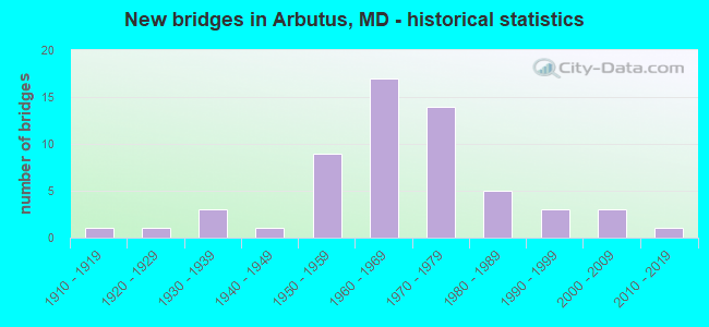
- New bridges - historical statistics
- 11910-1919
- 11920-1929
- 31930-1939
- 11940-1949
- 91950-1959
- 171960-1969
- 141970-1979
- 51980-1989
- 31990-1999
- 32000-2009
- 12010-2019
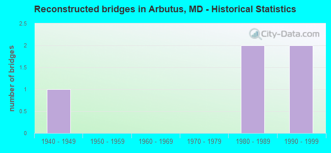
- Reconstructed bridges - Historical Statistics
- 11940-1949
- 01950-1959
- 01960-1969
- 01970-1979
- 21980-1989
- 21990-1999
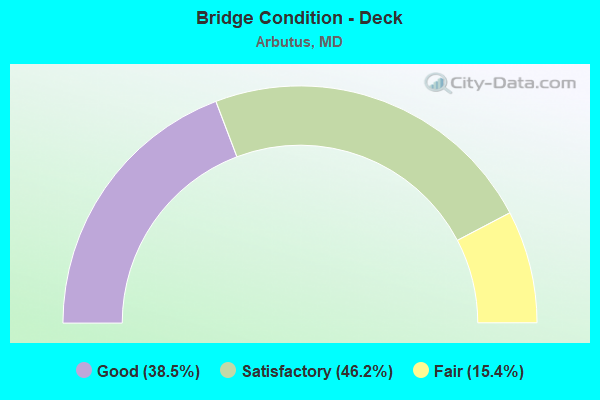
- Bridge Condition - Deck
- 38.5%Good
- 46.2%Satisfactory
- 15.4%Fair
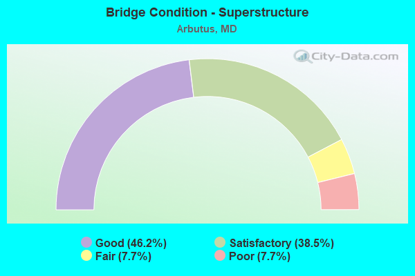
- Bridge Condition - Superstructure
- 46.2%Good
- 38.5%Satisfactory
- 7.7%Fair
- 7.7%Poor
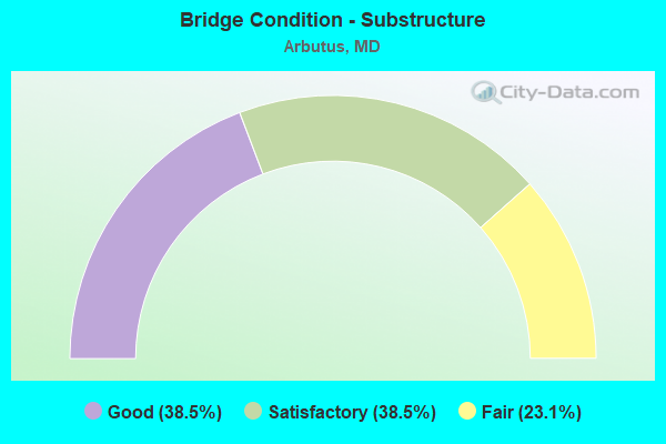
- Bridge Condition - Substructure
- 38.5%Good
- 38.5%Satisfactory
- 23.1%Fair
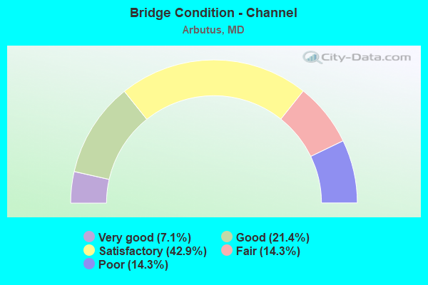
- Bridge Condition - Channel
- 7.1%Very good
- 21.4%Good
- 42.9%Satisfactory
- 14.3%Fair
- 14.3%Poor
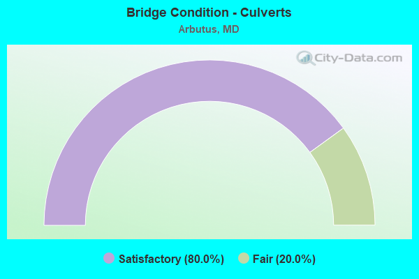
- Bridge Condition - Culverts
- 80.0%Satisfactory
- 20.0%Fair
Find on map >> Show street view
Structure Number: 100000020129014, Location: 0.96 MI E OF MD 295 (Lat: 39.216211, Lng: -76.699017), Route carried "on" structure: Interstate 195, Year Built: 1990, Status: Open, Structure Length: 67.21m (220.51ft), Average Daily Traffic: 39,015 (year 2009), Truck Traffic: 8%, Average Future Daily Traffic: 22,432 (year 2026), Design Load: HS 20+Mod, Features Intersected: AMTRAK, PATAPSCO RIVER
Minimum Vertical Clearance: 30+ m (98+ ft), Kilometerpoint: 3.760, Lanes on structure: 2, Lanes under structure: 2, Base Highway Network: Yes, Owner: State Highway Agency, Approaching Roadway Width: 14.0m (45.9ft), Skew: 9 degrees, Material/Design: Steel continuous, Design/Construction: Stringer/Multi-beam, Number Of Spans In Main Unit: 16, Length of Maximum Span: 62.8m (206.0ft), Curb-To-Curb Width: 12.2m (40.0ft), Out-to-Out Width: 13.4m (44.0ft)
Condition: Deck: Good, Superstructure: Good, Substructure: Satisfactory, Channel: Very good, Operating Rating: 73.5 metric tons, Method Used To Determine Operating Rating: Load Factor (LF), Inventory Rating: 44.0 metric tons, Method Used To Determine Inventory Rating: Load Factor (LF), Structural Evaluation: Equal to present minimum criteria, Deck Geometry: Better than present minimum criteria, Underclear: Better than present minimum criteria, Waterway Adequacy: Equal to present desirable criteria, Approach Roadway Alignment: Equal to present desirable criteria, Designated Inspection Frequency: Every 24 months, Inspection Date: January 2021, Deck Structure Type: Concrete Cast-file-Place, Wearing Surface/Protective System: Wearing Surface: Monolithic Concrete, Deck Protection: Epoxy Coated Reinforcing
Find on map >> Show street view
Structure Number: 10000003001001, Location: ON HOWARD CO LINE (Lat: 39.217931, Lng: -76.706294), Route carried "on" structure: US 1, Year Built: 1915, Year Reconstructed: 1952, Status: Open, Structure Length: 8.29m (27.20ft), Average Daily Traffic: 25,532 (year 2009), Truck Traffic: 8%, Average Future Daily Traffic: 29,173 (year 2033), Design Load: HS 20, Features Intersected: PATAPSCO RIVER
Minimum Vertical Clearance: 30+ m (98+ ft), Kilometerpoint: 0.000, Lanes on structure: 4, Base Highway Network: Yes, Owner: State Highway Agency, Approaching Roadway Width: 20.7m (67.9ft), Skew: 20 degrees, Material/Design: Concrete, Design/Construction: Arch - Deck, Number Of Spans In Main Unit: 2, Length of Maximum Span: 30.5m (100.1ft), Curb or Sidewalk Widths: Left: 1.6m (5.2ft), Right: 1.6m (5.2ft), Curb-To-Curb Width: 17.7m (58.1ft), Out-to-Out Width: 21.4m (70.2ft)
Condition: Deck: Fair, Superstructure: Fair, Substructure: Fair, Channel: Poor, Operating Rating: 83.4 metric tons, Method Used To Determine Operating Rating: Load Factor (LF), Inventory Rating: 49.9 metric tons, Method Used To Determine Inventory Rating: Load Factor (LF), Structural Evaluation: Somewhat better than minimum adequacy, Deck Geometry: Somewhat better than minimum adequacy, Waterway Adequacy: Better than present minimum criteria, Approach Roadway Alignment: Equal to present desirable criteria, Length Of Structure Improvement: 8.29m (27.20ft), Designated Inspection Frequency: Every 24 months, Underwater Inspection Frequency: Every 48 months, Inspection Date: March 2020, Underwater Inspection Date: July 2021, Bridge Improvement Cost: $1,146,000, Roadway Improvement Cost: $115,000, Total Project Cost: $1,261,000, Deck Structure Type: Concrete Cast-file-Place, Wearing Surface/Protective System: Wearing Surface: Bituminous
Find on map >> Show street view
Structure Number: 10000003001101, Location: 1.40 MI S OF IS 695 (Lat: 39.229742, Lng: -76.692464), Route carried "on" structure: Alternate US 1, Year Built: 1936, Year Reconstructed: 1980, Status: Open, Structure Length: 16.46m (54.00ft), Average Daily Traffic: 18,083 (year 2018), Truck Traffic: 8%, Average Future Daily Traffic: 21,461 (year 2038), Design Load: H 20, Features Intersected: US1 NBR, AMTRAK, HERBERT
Minimum Vertical Clearance: 30+ m (98+ ft), Kilometerpoint: 0.434, Lanes on structure: 4, Lanes under structure: 2, Base Highway Network: Yes, Owner: State Highway Agency, Approaching Roadway Width: 15.2m (49.9ft), Material/Design: Steel, Design/Construction: Girder and Floorbeam System, Number Of Spans In Main Unit: 5, Length of Maximum Span: 41.8m (137.1ft), Curb or Sidewalk Widths: Left: 0.9m (3.0ft), Right: 0.9m (3.0ft), Curb-To-Curb Width: 15.2m (49.9ft), Out-to-Out Width: 18.0m (59.1ft)
Condition: Deck: Satisfactory, Superstructure: Satisfactory, Substructure: Satisfactory, Channel: Good, Operating Rating: 53.1 metric tons, Method Used To Determine Operating Rating: Load Factor (LF), Inventory Rating: 31.7 metric tons, Method Used To Determine Inventory Rating: Load Factor (LF), Structural Evaluation: Equal to present minimum criteria, Deck Geometry: High priority of corrective action, Underclear: Equal to present minimum criteria, Waterway Adequacy: Superior to present desirable criteria, Approach Roadway Alignment: Equal to present desirable criteria, Designated Inspection Frequency: Every 24 months, Critical Feature Inspection Frequency: Every 24 months, Inspection Date: March 2020, Critical Feature Inspection Date: March 2020, Deck Structure Type: Concrete Cast-file-Place, Wearing Surface/Protective System: Wearing Surface: Monolithic Concrete, Deck Protection: Epoxy Coated Reinforcing
Find on map >> Show street view
Structure Number: 10000003019601, Location: 0.92 MI N OF US 1 (Lat: 39.248956, Lng: -76.679544), Route carried "on" structure: Ramp Interstate 695, Year Built: 1969, Status: Open, Structure Length: 5.91m (19.39ft), Average Daily Traffic: 25,791 (year 2007), Truck Traffic: 8%, Average Future Daily Traffic: 27,894 (year 2027), Design Load: HS 20, Features Intersected: IS 95 RAMP 'G'
Minimum Vertical Clearance: 30+ m (98+ ft), Kilometerpoint: 4.376, Lanes on structure: 1, Lanes under structure: 1, Base Highway Network: Yes, Owner: State Highway Agency, Approaching Roadway Width: 9.1m (29.9ft), Skew: 3 degrees, Material/Design: Concrete continuous, Design/Construction: Box Beam or Girders - Multiple, Number Of Spans In Main Unit: 3, Length of Maximum Span: 25.6m (84.0ft), Curb-To-Curb Width: 9.3m (30.5ft), Out-to-Out Width: 10.2m (33.5ft)
Condition: Deck: Satisfactory, Superstructure: Satisfactory, Substructure: Satisfactory, Operating Rating: 54.0 metric tons, Method Used To Determine Operating Rating: Load Factor (LF), Inventory Rating: 32.2 metric tons, Method Used To Determine Inventory Rating: Load Factor (LF), Structural Evaluation: Equal to present minimum criteria, Deck Geometry: Superior to present desirable criteria, Underclear: Somewhat better than minimum adequacy, Approach Roadway Alignment: Equal to present desirable criteria, Designated Inspection Frequency: Every 24 months, Inspection Date: December 2021, Deck Structure Type: Concrete Cast-file-Place, Wearing Surface/Protective System: Wearing Surface: Latex Concrete, Deck Protection: Cathodic Protection
Find on map >> Show street view
Structure Number: 200000B-009901, Location: 0.5 MI N SULPHUR SPRING R (Lat: 39.252019, Lng: -76.703033), Route carried "on" structure: County highway 3043, Year Built: 1920, Year Reconstructed: 1991, Status: Open, Structure Length: 1.01m (3.31ft), Average Daily Traffic: 3,539 (year 2021), Truck Traffic: 5%, Average Future Daily Traffic: 6,135 (year 2041), Features Intersected: HERBERT RUN, Facility Carried by Structure: SHELBOURNE ROAD
Minimum Vertical Clearance: 30+ m (98+ ft), Kilometerpoint: 0.788, Lanes on structure: 2, Owner: County Highway Agency, Approaching Roadway Width: 6.4m (21.0ft), Skew: 3 degrees, Material/Design: Concrete, Design/Construction: Slab, Number Of Spans In Main Unit: 2, Length of Maximum Span: 4.9m (16.1ft), Curb or Sidewalk Widths: Left: 0.0m, Right: 1.2m (3.9ft), Curb-To-Curb Width: 6.3m (20.7ft), Out-to-Out Width: 7.3m (24.0ft)
Condition: Deck: Satisfactory, Superstructure: Satisfactory, Substructure: Fair, Channel: Poor, Operating Rating: 75.7 metric tons, Method Used To Determine Operating Rating: Load Factor (LF), Inventory Rating: 45.4 metric tons, Method Used To Determine Inventory Rating: Load Factor (LF), Structural Evaluation: Somewhat better than minimum adequacy, Deck Geometry: High priority of replacement, Waterway Adequacy: Better than present minimum criteria, Approach Roadway Alignment: Equal to present desirable criteria, Designated Inspection Frequency: Every 24 months, Inspection Date: October 2021, Deck Structure Type: Concrete Cast-file-Place, Wearing Surface/Protective System: Wearing Surface: Bituminous, Deck Protection: Epoxy Coated Reinforcing
Find on map >> Show street view
Structure Number: 200000B-011301, Location: 50 FT W HAMMONDS FERRY RD (Lat: 39.252375, Lng: -76.664428), Route carried "on" structure: County highway 3227, Year Built: 1964, Status: Open, Structure Length: 5.00m (16.40ft), Average Daily Traffic: 7,040 (year 2018), Truck Traffic: 5%, Average Future Daily Traffic: 8,591 (year 2038), Design Load: HS 20, Features Intersected: CSX RAILROAD, Facility Carried by Structure: LANSDOWNE BOULEVAR
Minimum Vertical Clearance: 30+ m (98+ ft), Kilometerpoint: 1.706, Lanes on structure: 4, Owner: County Highway Agency, Approaching Roadway Width: 14.6m (47.9ft), Skew: 3 degrees, Material/Design: Steel, Design/Construction: Stringer/Multi-beam, Number Of Spans In Main Unit: 2, Length of Maximum Span: 30.5m (100.1ft), Curb or Sidewalk Widths: Left: 1.5m (4.9ft), Right: 1.5m (4.9ft), Curb-To-Curb Width: 14.6m (47.9ft), Out-to-Out Width: 18.3m (60.0ft)
Condition: Deck: Fair, Superstructure: Poor, Substructure: Fair, Operating Rating: 84.8 metric tons, Method Used To Determine Operating Rating: Load Factor (LF), Inventory Rating: 50.8 metric tons, Method Used To Determine Inventory Rating: Load Factor (LF), Structural Evaluation: Meets minimum limits, Deck Geometry: High priority of replacement, Underclear: Equal to present minimum criteria, Approach Roadway Alignment: Equal to present minimum criteria, Designated Inspection Frequency: Every 24 months, Inspection Date: January 2020, Deck Structure Type: Concrete Cast-file-Place, Wearing Surface/Protective System: Wearing Surface: Bituminous
Find on map >> Show street view
Structure Number: 200000B-018601, Location: 0.17 MI S OF LOCUST AVE (Lat: 39.250194, Lng: -76.704944), Route carried "on" structure: County highway 3043, Year Built: 1930, Year Reconstructed: 1990, Status: Open, Structure Length: 0.78m (2.56ft), Average Daily Traffic: 3,000 (year 2013), Truck Traffic: 5%, Average Future Daily Traffic: 5,600 (year 2040), Features Intersected: WEST HERBERT RUN, Facility Carried by Structure: SHELBOURNE RD
Minimum Vertical Clearance: 30+ m (98+ ft), Kilometerpoint: 0.547, Lanes on structure: 2, Owner: County Highway Agency, Approaching Roadway Width: 7.9m (25.9ft), Skew: 4 degrees, Material/Design: Prestressed concrete, Design/Construction: Stringer/Multi-beam, Number Of Spans In Main Unit: 1, Length of Maximum Span: 7.6m (24.9ft), Curb or Sidewalk Widths: Left: 0.3m (1.0ft), Right: 0.3m (1.0ft), Curb-To-Curb Width: 9.1m (29.9ft), Out-to-Out Width: 9.8m (32.2ft)
Condition: Deck: Good, Superstructure: Good, Substructure: Satisfactory, Channel: Fair, Inventory Rating: 57.1 metric tons, Method Used To Determine Inventory Rating: Load Factor (LF), Structural Evaluation: Equal to present minimum criteria, Deck Geometry: Meets minimum limits, Waterway Adequacy: Equal to present minimum criteria, Approach Roadway Alignment: Equal to present desirable criteria, Designated Inspection Frequency: Every 24 months, Inspection Date: June 2021, Wearing Surface/Protective System: Wearing Surface: Bituminous
Find on map >> Show street view
Structure Number: 200000B-021901, Location: 0.06 MI S OF EAST DR (Lat: 39.250047, Lng: -76.692467), Route carried "on" structure: County highway 3033, Year Built: 1982, Status: Open, Structure Length: 1.52m (4.99ft), Average Daily Traffic: 4,590 (year 2021), Truck Traffic: 5%, Average Future Daily Traffic: 5,610 (year 2041), Design Load: HS 20, Features Intersected: HERBERT RUN, Facility Carried by Structure: LINDEN AVENUE
Minimum Vertical Clearance: 30+ m (98+ ft), Kilometerpoint: 0.145, Lanes on structure: 2, Owner: County Highway Agency, Approaching Roadway Width: 9.1m (29.9ft), Skew: 2 degrees, Material/Design: Prestressed concrete, Design/Construction: Box Beam or Girders - Multiple, Number Of Spans In Main Unit: 1, Length of Maximum Span: 14.6m (47.9ft), Curb or Sidewalk Widths: Left: 1.5m (4.9ft), Right: 1.5m (4.9ft), Curb-To-Curb Width: 9.1m (29.9ft), Out-to-Out Width: 12.9m (42.3ft)
Condition: Deck: Good, Superstructure: Satisfactory, Substructure: Good, Channel: Good, Operating Rating: 43.5 metric tons, Method Used To Determine Operating Rating: Load Factor (LF), Inventory Rating: 25.8 metric tons, Method Used To Determine Inventory Rating: Load Factor (LF), Structural Evaluation: Equal to present minimum criteria, Deck Geometry: Meets minimum limits, Waterway Adequacy: Equal to present desirable criteria, Approach Roadway Alignment: Equal to present minimum criteria, Designated Inspection Frequency: Every 24 months, Inspection Date: June 2021, Wearing Surface/Protective System: Wearing Surface: Bituminous
Find on map >> Show street view
Structure Number: 200000B-031902, Location: 0.08 MI W OF OREGON AVE (Lat: 39.241797, Lng: -76.695300), Route carried "on" structure: County highway 3082, Year Built: 1953, Status: Open, Structure Length: 1.07m (3.51ft), Average Daily Traffic: 2,600 (year 2021), Truck Traffic: 5%, Average Future Daily Traffic: 3,570 (year 2041), Design Load: H 20, Features Intersected: WEST HERBERT RUN, Facility Carried by Structure: ELM ROAD
Minimum Vertical Clearance: 30+ m (98+ ft), Kilometerpoint: 0.129, Lanes on structure: 2, Owner: County Highway Agency, Approaching Roadway Width: 11.0m (36.1ft), Material/Design: Concrete, Design/Construction: Culvert, Length of Maximum Span: 4.9m (16.1ft), Curb or Sidewalk Widths: Left: 1.8m (5.9ft), Right: 1.8m (5.9ft), Curb-To-Curb Width: 11.0m (36.1ft), Out-to-Out Width: 11.0m (36.1ft)
Condition: Channel: Satisfactory, Culverts: Satisfactory, Operating Rating: 55.3 metric tons, Method Used To Determine Operating Rating: Load Factor (LF), Inventory Rating: 32.7 metric tons, Method Used To Determine Inventory Rating: Load Factor (LF), Structural Evaluation: Equal to present minimum criteria, Deck Geometry: Somewhat better than minimum adequacy, Waterway Adequacy: Better than present minimum criteria, Approach Roadway Alignment: Equal to present desirable criteria, Designated Inspection Frequency: Every 24 months, Inspection Date: June 2021
Find on map >> Show street view
Structure Number: 200000B-032302, Location: 0.06 MI W OF OREGON AVE (Lat: 39.238447, Lng: -76.694950), Route carried "on" structure: County highway 3064, Year Built: 1955, Status: Open, Structure Length: 0.94m (3.08ft), Average Daily Traffic: 8,130 (year 2021), Truck Traffic: 5%, Average Future Daily Traffic: 9,920 (year 2041), Design Load: H 20, Features Intersected: WEST BRANCH OF HERBERT R, Facility Carried by Structure: FRANCIS AVENUE
Minimum Vertical Clearance: 30+ m (98+ ft), Kilometerpoint: 0.097, Lanes on structure: 2, Owner: County Highway Agency, Approaching Roadway Width: 11.0m (36.1ft), Material/Design: Concrete, Design/Construction: Culvert, Length of Maximum Span: 4.6m (15.1ft), Curb or Sidewalk Widths: Left: 1.8m (5.9ft), Right: 1.8m (5.9ft)
Condition: Channel: Satisfactory, Culverts: Satisfactory, Operating Rating: 65.3 metric tons, Method Used To Determine Operating Rating: Load Factor (LF), Inventory Rating: 39.0 metric tons, Method Used To Determine Inventory Rating: Load Factor (LF), Structural Evaluation: Equal to present minimum criteria, Waterway Adequacy: Better than present minimum criteria, Approach Roadway Alignment: Equal to present desirable criteria, Designated Inspection Frequency: Every 24 months, Inspection Date: June 2021
Find on map >> Show street view
Structure Number: 200000B-033002, Location: 0.40 MI W OF US 1 (Lat: 39.247342, Lng: -76.699072), Route carried "on" structure: County highway 3071, Year Built: 1959, Status: Open, Structure Length: 1.33m (4.36ft), Average Daily Traffic: 4,270 (year 2021), Truck Traffic: 5%, Average Future Daily Traffic: 5,200 (year 2041), Design Load: HS 20, Features Intersected: WEST BRANCH, Facility Carried by Structure: SULPHUR SPRING ROA
Minimum Vertical Clearance: 30+ m (98+ ft), Kilometerpoint: 1.512, Lanes on structure: 2, Owner: County Highway Agency, Approaching Roadway Width: 12.8m (42.0ft), Skew: 4 degrees, Material/Design: Concrete, Design/Construction: Culvert, Length of Maximum Span: 4.6m (15.1ft), Curb or Sidewalk Widths: Left: 1.5m (4.9ft), Right: 1.8m (5.9ft)
Condition: Channel: Satisfactory, Culverts: Satisfactory, Operating Rating: 42.2 metric tons, Method Used To Determine Operating Rating: Load Factor (LF), Inventory Rating: 25.8 metric tons, Method Used To Determine Inventory Rating: Load Factor (LF), Structural Evaluation: Equal to present minimum criteria, Waterway Adequacy: Equal to present desirable criteria, Approach Roadway Alignment: Equal to present desirable criteria, Bridge Posting: Required (Relationship of Operating Rating to Maximum Legal Load: 10.0 - 19.9% below), Designated Inspection Frequency: Every 24 months, Inspection Date: August 2021, Wearing Surface/Protective System: Wearing Surface: Bituminous
Find on map >> Show street view
Structure Number: 200000B-034802, Location: INTER SELMA & SUL SPRNG (Lat: 39.248186, Lng: -76.693264), Route carried "on" structure: County highway 3191, Year Built: 1962, Status: Open, Structure Length: 1.64m (5.38ft), Average Daily Traffic: 20,845 (year 2021), Truck Traffic: 5%, Average Future Daily Traffic: 25,500 (year 2041), Design Load: HS 20, Features Intersected: HERBERT RUN, Facility Carried by Structure: SULPHUR SPRING RD
Minimum Vertical Clearance: 30+ m (98+ ft), Kilometerpoint: 0.611, Lanes on structure: 5, Owner: County Highway Agency, Approaching Roadway Width: 8.5m (27.9ft), Skew: 20 degrees, Material/Design: Concrete, Design/Construction: Culvert, Length of Maximum Span: 5.8m (19.0ft)
Condition: Channel: Satisfactory, Culverts: Fair, Operating Rating: 58.5 metric tons, Method Used To Determine Operating Rating: Load Factor (LF), Inventory Rating: 35.8 metric tons, Method Used To Determine Inventory Rating: Load Factor (LF), Structural Evaluation: Somewhat better than minimum adequacy, Waterway Adequacy: Better than present minimum criteria, Approach Roadway Alignment: Better than present minimum criteria, Designated Inspection Frequency: Every 24 months, Inspection Date: August 2021, Wearing Surface/Protective System: Wearing Surface: Bituminous
Find on map >> Show street view
Structure Number: 200000B-039502, Location: 0.02 MI W OF US 1 (Lat: 4.528469, Lng: -8.070325), Route carried "on" structure: County highway 6101, Year Built: 1960, Year Reconstructed: 1998, Status: Open, Structure Length: 0.61m (2.00ft), Average Daily Traffic: 1,665 (year 2021), Truck Traffic: 10%, Average Future Daily Traffic: 3,400 (year 2041), Features Intersected: EAST BRANCH HERBERT RUN, Facility Carried by Structure: TOM DAY BOULEVARD
Minimum Vertical Clearance: 30+ m (98+ ft), Kilometerpoint: 0.129, Lanes on structure: 2, Owner: County Highway Agency, Approaching Roadway Width: 10.4m (34.1ft), Material/Design: Concrete, Design/Construction: Culvert, Length of Maximum Span: 6.1m (20.0ft)
Condition: Channel: Satisfactory, Culverts: Satisfactory, Operating Rating: 57.6 metric tons, Method Used To Determine Operating Rating: Load Factor (LF), Inventory Rating: 34.5 metric tons, Method Used To Determine Inventory Rating: Load Factor (LF), Structural Evaluation: Equal to present minimum criteria, Waterway Adequacy: Better than present minimum criteria, Approach Roadway Alignment: Better than present minimum criteria, Designated Inspection Frequency: Every 24 months, Inspection Date: July 2021
Find on map >> Show street view
Structure Number: 200000B-048701, Location: 0.05 MI E OF CARVILLE AVE (Lat: 39.238878, Lng: -76.692794), Route carried "on" structure: County highway , Year Built: 1997, Status: Open, Structure Length: 18.50m (60.70ft), Average Daily Traffic: 7,405 (year 2017), Truck Traffic: 8%, Average Future Daily Traffic: 9,034 (year 2037), Design Load: HS 25 or greater, Features Intersected: US RT. 1, AMTRAK, POTOMA, Facility Carried by Structure: FRANCIS AVENUE
Minimum Vertical Clearance: 30+ m (98+ ft), Kilometerpoint: 2.832, Lanes on structure: 2, Lanes under structure: 6, Owner: County Highway Agency, Approaching Roadway Width: 8.5m (27.9ft), Material/Design: Steel continuous, Design/Construction: Stringer/Multi-beam, Number Of Spans In Main Unit: 5, Length of Maximum Span: 49.7m (163.1ft), Curb or Sidewalk Widths: Left: 1.3m (4.3ft), Right: 1.3m (4.3ft), Curb-To-Curb Width: 8.5m (27.9ft), Out-to-Out Width: 11.8m (38.7ft)
Condition: Deck: Good, Superstructure: Good, Substructure: Good, Channel: Fair, Inventory Rating: 77.5 metric tons, Method Used To Determine Inventory Rating: Load Factor (LF), Structural Evaluation: Better than present minimum criteria, Deck Geometry: Meets minimum limits, Underclear: Meets minimum limits, Approach Roadway Alignment: Equal to present minimum criteria, Designated Inspection Frequency: Every 24 months, Inspection Date: January 2020, Deck Structure Type: Concrete Cast-file-Place, Wearing Surface/Protective System: Wearing Surface: Monolithic Concrete, Deck Protection: Epoxy Coated Reinforcing
Find on map >> Show street view
Structure Number: 300000B-NR0201, Location: PATAPSCO VALLEY ST PARK (Lat: 39.226981, Lng: -76.723203), Route carried "on" structure: State lands road 3095, Year Built: 1975, Status: Open, Structure Length: 4.54m (14.90ft), Average Daily Traffic: 110 (year 2010), Truck Traffic: 5%, Average Future Daily Traffic: 120 (year 2035), Design Load: HS 20, Features Intersected: PATAPSCO RIVER, Facility Carried by Structure: GUN ROAD
Minimum Vertical Clearance: 30+ m (98+ ft), Kilometerpoint: 0.000, Lanes on structure: 2, Owner: State Agenciy, Approaching Roadway Width: 7.3m (24.0ft), Material/Design: Steel, Design/Construction: Stringer/Multi-beam, Number Of Spans In Main Unit: 1, Length of Maximum Span: 44.2m (145.0ft), Curb or Sidewalk Widths: Left: 0.0m, Right: 1.8m (5.9ft), Curb-To-Curb Width: 7.3m (24.0ft), Out-to-Out Width: 9.9m (32.5ft)
Condition: Deck: Good, Superstructure: Good, Substructure: Good, Channel: Good, Inventory Rating: 67.6 metric tons, Method Used To Determine Inventory Rating: Allowable Stress (AS), Structural Evaluation: Better than present minimum criteria, Deck Geometry: Somewhat better than minimum adequacy, Waterway Adequacy: Equal to present desirable criteria, Approach Roadway Alignment: Equal to present desirable criteria, Designated Inspection Frequency: Every 24 months, Inspection Date: August 2020, Deck Structure Type: Concrete Cast-file-Place, Wearing Surface/Protective System: Wearing Surface: Integral Concrete
Find on map >> Show street view
Structure Number: 300000B-Y018012, Location: Milepost M1.8 (Lat: 39.220208, Lng: -76.696308), Route carried "on" structure: Interstate 895, Year Built: 1957, Status: Open, Structure Length: 3.66m (12.01ft), Average Daily Traffic: 8,846 (year 2019), Truck Traffic: 7%, Average Future Daily Traffic: 11,253 (year 2041), Design Load: HS 20, Features Intersected: CALVERT ACCESS ROAD S
Minimum Vertical Clearance: 30+ m (98+ ft), Kilometerpoint: 2.961, Lanes on structure: 2, Lanes under structure: 2, Base Highway Network: Yes, Toll: On toll road, Owner: State Toll Authority, Approaching Roadway Width: 12.8m (42.0ft), Material/Design: Steel, Design/Construction: Stringer/Multi-beam, Number Of Spans In Main Unit: 3, Length of Maximum Span: 12.8m (42.0ft), Curb-To-Curb Width: 12.8m (42.0ft), Out-to-Out Width: 14.1m (46.3ft)
Condition: Deck: Satisfactory, Superstructure: Good, Substructure: Satisfactory, Operating Rating: 79.4 metric tons, Method Used To Determine Operating Rating: Load Factor (LF), Inventory Rating: 47.6 metric tons, Method Used To Determine Inventory Rating: Load Factor (LF), Structural Evaluation: Equal to present minimum criteria, Deck Geometry: Equal to present desirable criteria, Underclear: High priority of corrective action, Approach Roadway Alignment: Equal to present desirable criteria, Designated Inspection Frequency: Every 24 months, Inspection Date: January 2022, Deck Structure Type: Closed Grating, Wearing Surface/Protective System: Wearing Surface: Monolithic Concrete
Find on map >> Show street view
Structure Number: 300000B-Y020012, Location: Milepost M2.0 (Lat: 39.221408, Lng: -76.694119), Route carried "on" structure: Interstate 895, Year Built: 1957, Status: Open, Structure Length: 6.10m (20.01ft), Average Daily Traffic: 8,846 (year 2019), Truck Traffic: 7%, Average Future Daily Traffic: 11,253 (year 2041), Design Load: HS 20, Features Intersected: AMTRAK
Minimum Vertical Clearance: 30+ m (98+ ft), Kilometerpoint: 3.202, Lanes on structure: 2, Base Highway Network: Yes, Toll: On toll road, Owner: State Toll Authority, Approaching Roadway Width: 12.8m (42.0ft), Skew: 13 degrees, Material/Design: Steel, Design/Construction: Stringer/Multi-beam, Number Of Spans In Main Unit: 3, Length of Maximum Span: 26.2m (86.0ft), Curb-To-Curb Width: 12.8m (42.0ft), Out-to-Out Width: 14.1m (46.3ft)
Condition: Deck: Satisfactory, Superstructure: Good, Substructure: Good, Operating Rating: 66.2 metric tons, Method Used To Determine Operating Rating: Load Factor (LF), Inventory Rating: 39.5 metric tons, Method Used To Determine Inventory Rating: Load Factor (LF), Structural Evaluation: Better than present minimum criteria, Deck Geometry: Equal to present desirable criteria, Underclear: Equal to present minimum criteria, Approach Roadway Alignment: Equal to present desirable criteria, Designated Inspection Frequency: Every 24 months, Inspection Date: December 2021, Deck Structure Type: Closed Grating, Wearing Surface/Protective System: Wearing Surface: Monolithic Concrete
Find on map >> Show street view
Structure Number: 300000HOY01201, Location: Milepost 1.2 (Lat: 39.218550, Lng: -76.704228), Route carried "on" structure: Ramp Interstate 895, Year Built: 1959, Status: Open, Structure Length: 20.73m (68.01ft), Average Daily Traffic: 1,643 (year 2019), Truck Traffic: 2%, Average Future Daily Traffic: 2,090 (year 2041), Design Load: HS 20, Features Intersected: US 1,PATAPSCO RIVER
Minimum Vertical Clearance: 30+ m (98+ ft), Kilometerpoint: 1.931, Lanes on structure: 1, Lanes under structure: 4, Base Highway Network: Yes, Toll: On toll road, Owner: State Toll Authority, Approaching Roadway Width: 7.9m (25.9ft), Skew: 9 degrees, Material/Design: Steel, Design/Construction: Stringer/Multi-beam, Number Of Spans In Main Unit: 9, Length of Maximum Span: 40.8m (133.9ft), Curb-To-Curb Width: 7.9m (25.9ft), Out-to-Out Width: 9.2m (30.2ft)
Condition: Deck: Satisfactory, Superstructure: Satisfactory, Substructure: Good, Channel: Satisfactory, Operating Rating: 74.8 metric tons, Method Used To Determine Operating Rating: Load Factor (LF), Inventory Rating: 44.9 metric tons, Method Used To Determine Inventory Rating: Load Factor (LF), Structural Evaluation: Equal to present minimum criteria, Deck Geometry: Equal to present desirable criteria, Underclear: Somewhat better than minimum adequacy, Waterway Adequacy: Superior to present desirable criteria, Approach Roadway Alignment: Better than present minimum criteria, Designated Inspection Frequency: Every 24 months, Inspection Date: January 2020, Deck Structure Type: Concrete Cast-file-Place, Wearing Surface/Protective System: Wearing Surface: Monolithic Concrete
Find on map >> Show street view
Structure Number: 10000003000501, Location: 0.33 MI N OF IS 95 (Lat: 39.247839, Lng: -76.691486), Route carried "under" structure: County highway 3071, Year Built: 1947, Structure Length: 0. m, Average Daily Traffic: 10,249 (year 2007), Features Intersected: SULPHUR SPRING ROAD, Facility Carried by Structure: US 1
Minimum Vertical Clearance: 4.57m (14.99ft), Kilometerpoint: 2.204, Lanes on structure: 4, Lanes under structure: 4, Material/Design: Steel, Design/Construction: Stringer/Multi-beam, Length of Maximum Span: 21.0m (68.9ft)
Find on map >> Show street view
Structure Number: 10000003001101, Location: 1.40 MI S OF IS 695 (Lat: 39.229839, Lng: -76.692558), Route carried "under" structure: US 1, Year Built: 1936, Structure Length: 0. m, Average Daily Traffic: 11,542 (year 2009), Features Intersected: US1 NBR, AMTRAK, HERBERT
Minimum Vertical Clearance: 6.10m (20.01ft), Kilometerpoint: 1.834, Lanes on structure: 4, Lanes under structure: 2, Material/Design: Steel, Design/Construction: Girder and Floorbeam System, Length of Maximum Span: 42.4m (139.1ft)
Find on map >> Show street view
Structure Number: 10000003011114, Location: 0.20 MI E OF MD 891 (Lat: 39.239133, Lng: -76.668833), Route carried "under" structure: Interstate 695, Year Built: 1957, Structure Length: 0. m, Features Intersected: I-695, Facility Carried by Structure: CSX TRANSPORTATION
Minimum Vertical Clearance: 30+ m (98+ ft), Kilometerpoint: 1.009, Lanes under structure: 6, Material/Design: Steel, Design/Construction: Stringer/Multi-beam, Length of Maximum Span: 22.9m (75.1ft)
Find on map >> Show street view
Structure Number: 10000003011201, Location: 1.40 MI N OF US 1 (Lat: 39.244703, Lng: -76.674081), Route carried "under" structure: Interstate 695, Year Built: 1957, Structure Length: 0. m, Average Daily Traffic: 125,332 (year 2009), Features Intersected: IS 695, Facility Carried by Structure: US 1 ALT
Minimum Vertical Clearance: 4.88m (16.01ft), Kilometerpoint: 1.818, Lanes on structure: 7, Lanes under structure: 8, Material/Design: Steel, Design/Construction: Stringer/Multi-beam, Length of Maximum Span: 21.3m (69.9ft)
Find on map >> Show street view
Structure Number: 100000030113016, Location: 0.18 MI S OF US 1 (Lat: 39.255067, Lng: -76.688267), Route carried "under" structure: County highway 3022, Year Built: 2004, Structure Length: 0. m, Average Daily Traffic: 4,088 (year 2006), Features Intersected: BENSON AVENUE, Facility Carried by Structure: IS 695
Minimum Vertical Clearance: 5.49m (18.01ft), Kilometerpoint: 0.676, Lanes on structure: 4, Lanes under structure: 2, Material/Design: Steel, Design/Construction: Stringer/Multi-beam, Length of Maximum Span: 38.1m (125.0ft)
Find on map >> Show street view
Structure Number: 100000030114016, Location: 0.88 MILE NORTH OF IS 95 (Lat: 39.256169, Lng: -76.692258), Route carried "under" structure: US 1, Year Built: 2003, Structure Length: 0. m, Average Daily Traffic: 7,492 (year 2009), Features Intersected: US 1, AMTRAK, LEEDS AVE, Facility Carried by Structure: IS 695
Minimum Vertical Clearance: 6.40m (21.00ft), Kilometerpoint: 4.714, Lanes on structure: 5, Lanes under structure: 6, Material/Design: Steel continuous, Design/Construction: Stringer/Multi-beam, Length of Maximum Span: 52.1m (170.9ft)
Find on map >> Show street view
Structure Number: 10000003011601, Location: 0.92 MILES N OF I-95 (Lat: 39.256464, Lng: -76.691506), Route carried "under" structure: Ramp Interstate 695, Year Built: 2016, Structure Length: 0. m, Average Daily Traffic: 7,050 (year 2015), Features Intersected: LEEDS AVE & HERBERT RUN
Minimum Vertical Clearance: 6.71m (22.01ft), Kilometerpoint: 0.000, Lanes on structure: 1, Lanes under structure: 2, Length of Maximum Span: 29.0m (95.1ft)
Find on map >> Show street view
Structure Number: 10000003011801, Location: 0.43 MILE NORTH OF US 1 (Lat: 39.257825, Lng: -76.698781), Route carried "under" structure: Interstate 695, Year Built: 1957, Structure Length: 0. m, Average Daily Traffic: 192,702 (year 2009), Features Intersected: IS 695, Facility Carried by Structure: WESTLAND BLVD
Minimum Vertical Clearance: 4.88m (16.01ft), Kilometerpoint: 4.489, Lanes on structure: 2, Lanes under structure: 7, Material/Design: Steel, Design/Construction: Stringer/Multi-beam, Length of Maximum Span: 30.8m (101.0ft)
Find on map >> Show street view
Structure Number: 100000030119016, Location: 0.32 M E OF PARADISE AVE (Lat: 39.262161, Lng: -76.706167), Route carried "under" structure: State highway 372, Year Built: 2004, Structure Length: 0. m, Average Daily Traffic: 1,911 (year 2012), Truck Traffic: 12%, Features Intersected: MD 372, Facility Carried by Structure: IS 695
Minimum Vertical Clearance: 4.88m (16.01ft), Kilometerpoint: 2.269, Lanes on structure: 10, Lanes under structure: 4, Material/Design: Steel continuous, Design/Construction: Stringer/Multi-beam, Length of Maximum Span: 35.1m (115.2ft)
Find on map >> Show street view
Structure Number: 10000003019501, Location: 0.84 MI N OF US 1 (Lat: 39.249567, Lng: -76.678153), Route carried "under" structure: Interstate 695, Year Built: 1969, Structure Length: 0. m, Average Daily Traffic: 125,332 (year 2009), Features Intersected: IS 695, Facility Carried by Structure: IS 95 RAMP 'C'
Minimum Vertical Clearance: 4.88m (16.01ft), Kilometerpoint: 2.462, Lanes on structure: 1, Lanes under structure: 4, Material/Design: Steel continuous, Design/Construction: Stringer/Multi-beam, Length of Maximum Span: 30.5m (100.1ft)
Find on map >> Show street view
Structure Number: 10000003019601, Location: 0.92 MI N OF US 1 (Lat: 39.248847, Lng: -76.680222), Route carried "under" structure: Ramp Interstate 95, Year Built: 1969, Structure Length: 0. m, Average Daily Traffic: 14,039 (year 2007), Features Intersected: IS 95 RAMP 'G'
Minimum Vertical Clearance: 4.88m (16.01ft), Kilometerpoint: 4.376, Lanes on structure: 1, Lanes under structure: 1, Material/Design: Steel continuous, Design/Construction: Box Beam or Girders - Multiple, Length of Maximum Span: 25.6m (84.0ft)
Find on map >> Show street view
Structure Number: 10000003019701, Location: 0.71 MI N OF US 1 (Lat: 39.248794, Lng: -76.681278), Route carried "under" structure: Ramp Interstate 695, Year Built: 1969, Structure Length: 0. m, Average Daily Traffic: 39,830 (year 2006), Features Intersected: IS 695 RAMPS 'C' & 'G', Facility Carried by Structure: IS 95 NBR
Minimum Vertical Clearance: 4.88m (16.01ft), Kilometerpoint: 4.296, Lanes on structure: 4, Lanes under structure: 2, Material/Design: Steel continuous, Design/Construction: Stringer/Multi-beam, Length of Maximum Span: 24.4m (80.1ft)
Find on map >> Show street view
Structure Number: 10000003019801, Location: 1.02 MI N OF US 1 (Lat: 39.253531, Lng: -76.678725), Route carried "under" structure: Ramp Interstate 95, Year Built: 1969, Structure Length: 0. m, Average Daily Traffic: 29,950 (year 2006), Features Intersected: IS 95 RAMP 'I'
Minimum Vertical Clearance: 4.88m (16.01ft), Kilometerpoint: 4.795, Lanes on structure: 5, Lanes under structure: 1, Material/Design: Concrete continuous, Design/Construction: Slab, Length of Maximum Span: 19.5m (64.0ft)
Find on map >> Show street view
Structure Number: 10000003019901, Location: 0.84 MI N OF US 1 (Lat: 39.251564, Lng: -76.680517), Route carried "under" structure: Interstate 695, Year Built: 1969, Structure Length: 0. m, Average Daily Traffic: 177,562 (year 2009), Features Intersected: IS 695, Facility Carried by Structure: IS 95 SBR
Minimum Vertical Clearance: 4.88m (16.01ft), Kilometerpoint: 2.767, Lanes on structure: 5, Lanes under structure: 4, Material/Design: Steel continuous, Design/Construction: Stringer/Multi-beam, Length of Maximum Span: 29.6m (97.1ft)
Find on map >> Show street view
Structure Number: 10000003020001, Location: 0.68 MI N OF US 1 (Lat: 39.249911, Lng: -76.682228), Route carried "under" structure: Ramp Interstate 695, Year Built: 1969, Structure Length: 0. m, Average Daily Traffic: 25,791 (year 2006), Features Intersected: IS 695 RAMP 'C', Facility Carried by Structure: IS 95 SBR
Minimum Vertical Clearance: 5.18m (16.99ft), Kilometerpoint: 4.248, Lanes on structure: 4, Lanes under structure: 1, Material/Design: Concrete continuous, Design/Construction: Slab, Length of Maximum Span: 18.0m (59.1ft)
Find on map >> Show street view
Structure Number: 10000003020101, Location: 0.66 MILE SOUTH OF US 1 (Lat: 39.251431, Lng: -76.680322), Route carried "under" structure: Interstate 695, Year Built: 1969, Structure Length: 0. m, Average Daily Traffic: 125,332 (year 2009), Features Intersected: IS 695, Facility Carried by Structure: IS 95 RAMP 'G'
Minimum Vertical Clearance: 4.88m (16.01ft), Kilometerpoint: 2.735, Lanes on structure: 1, Lanes under structure: 4, Material/Design: Steel continuous, Design/Construction: Stringer/Multi-beam, Length of Maximum Span: 33.2m (108.9ft)
Find on map >> Show street view
Structure Number: 10000003020201, Location: 0.77 MILE SOUTH OF US 1 (Lat: 39.249942, Lng: -76.679408), Route carried "under" structure: Interstate 695, Year Built: 1969, Structure Length: 0. m, Average Daily Traffic: 125,332 (year 2009), Features Intersected: IS 695, Facility Carried by Structure: IS 95 NBR
Minimum Vertical Clearance: 4.88m (16.01ft), Kilometerpoint: 2.558, Lanes on structure: 4, Lanes under structure: 4, Material/Design: Steel continuous, Design/Construction: Stringer/Multi-beam, Length of Maximum Span: 30.5m (100.1ft)
Find on map >> Show street view
Structure Number: 100000030243012, Location: ON HOWARD CO LINE (Lat: 39.227486, Lng: -76.716217), Route carried "under" structure: ServiceState lands road , Year Built: 1968, Structure Length: 0. m, Average Daily Traffic: 99 (year 2006), Features Intersected: CSX TRANS,PAT RIV,CO RD, Facility Carried by Structure: IS 95 SBR
Minimum Vertical Clearance: 16.76m (54.99ft), Kilometerpoint: 1.207, Lanes on structure: 4, Lanes under structure: 2, Material/Design: Steel continuous, Design/Construction: Stringer/Multi-beam, Length of Maximum Span: 53.0m (173.9ft)
Find on map >> Show street view
Structure Number: 100000030253011, Location: 0.4 MILE SOUTH OF MD 166 (Lat: 39.234786, Lng: -76.710494), Route carried "under" structure: Interstate 195, Year Built: 1970, Structure Length: 0. m, Average Daily Traffic: 27,681 (year 2009), Features Intersected: IS 195, Facility Carried by Structure: IS 95 NBR
Minimum Vertical Clearance: 4.88m (16.01ft), Kilometerpoint: 2.816, Lanes on structure: 4, Lanes under structure: 4, Material/Design: Steel continuous, Design/Construction: Stringer/Multi-beam, Length of Maximum Span: 51.8m (169.9ft)
Find on map >> Show street view
Structure Number: 100000030253012, Location: 0.4 MILE SOUTH OF MD 166 (Lat: 39.236744, Lng: -76.708661), Route carried "under" structure: Interstate 195, Year Built: 1970, Structure Length: 0. m, Average Daily Traffic: 27,681 (year 2009), Features Intersected: IS 195, Facility Carried by Structure: IS 95 SBR
Minimum Vertical Clearance: 4.88m (16.01ft), Kilometerpoint: 2.816, Lanes on structure: 4, Lanes under structure: 4, Material/Design: Steel continuous, Design/Construction: Stringer/Multi-beam, Length of Maximum Span: 51.8m (169.9ft)
Find on map >> Show street view
Structure Number: 10000003025401, Location: 0.13 MILE NORTH OF IS 195 (Lat: 39.236458, Lng: -76.707550), Route carried "under" structure: Interstate 95, Year Built: 1970, Structure Length: 0. m, Average Daily Traffic: 176,796 (year 2009), Features Intersected: IS 95, Facility Carried by Structure: SELFORD ROAD
Minimum Vertical Clearance: 4.88m (16.01ft), Kilometerpoint: 1.512, Lanes on structure: 2, Lanes under structure: 8, Material/Design: Steel continuous, Design/Construction: Stringer/Multi-beam, Length of Maximum Span: 41.1m (134.8ft)
Find on map >> Show street view
Structure Number: 10000003025501, Location: 0.26 MILE NORTH OF IS 195 (Lat: 39.237047, Lng: -76.710769), Route carried "under" structure: Interstate 195, Year Built: 1970, Structure Length: 0. m, Average Daily Traffic: 27,681 (year 2009), Features Intersected: I195 NBR, Facility Carried by Structure: IS 95 RAMP 'A'5
Minimum Vertical Clearance: 4.88m (16.01ft), Kilometerpoint: 0.418, Lanes on structure: 1, Lanes under structure: 2, Material/Design: Steel, Design/Construction: Stringer/Multi-beam, Length of Maximum Span: 26.5m (86.9ft)
Find on map >> Show street view
Structure Number: 10000003025601, Location: 0.79 MI N OF HOWARD CO (Lat: 39.233442, Lng: -76.708467), Route carried "under" structure: Interstate 195, Year Built: 1970, Structure Length: 0. m, Average Daily Traffic: 41,831 (year 2009), Features Intersected: IS 195 SBR, Facility Carried by Structure: IS 95 RAMP 'E'
Minimum Vertical Clearance: 4.88m (16.01ft), Kilometerpoint: 25.889, Lanes on structure: 1, Lanes under structure: 3, Material/Design: Steel, Design/Construction: Stringer/Multi-beam, Length of Maximum Span: 26.8m (87.9ft)
Find on map >> Show street view
Structure Number: 100000030260011, Location: 0.32 MI S OF IS 695 (Lat: 39.247325, Lng: -76.684306), Route carried "under" structure: County highway 3071, Year Built: 1971, Structure Length: 0. m, Average Daily Traffic: 11,274 (year 2012), Features Intersected: SULPHUR SPRING ROAD, Facility Carried by Structure: IS 95 NBR
Minimum Vertical Clearance: 4.57m (14.99ft), Kilometerpoint: 2.838, Lanes on structure: 4, Lanes under structure: 2, Material/Design: Steel, Design/Construction: Stringer/Multi-beam, Length of Maximum Span: 21.0m (68.9ft)
Find on map >> Show street view
Structure Number: 100000030260012, Location: 0.32 MI S OF IS 695 (Lat: 39.248533, Lng: -76.683856), Route carried "under" structure: County highway 3071, Year Built: 1971, Structure Length: 0. m, Average Daily Traffic: 11,274 (year 2012), Features Intersected: SULPHUR SPRING ROAD, Facility Carried by Structure: IS 95 SBR
Minimum Vertical Clearance: 4.57m (14.99ft), Kilometerpoint: 2.776, Lanes on structure: 4, Lanes under structure: 2, Material/Design: Steel, Design/Construction: Stringer/Multi-beam, Length of Maximum Span: 20.1m (65.9ft)
Find on map >> Show street view
Structure Number: 100000030261011, Location: 0.88 MILE SOUTH OF IS 695 (Lat: 39.242642, Lng: -76.691886), Route carried "under" structure: US 1, Year Built: 1970, Structure Length: 0. m, Average Daily Traffic: 11,542 (year 2009), Features Intersected: US 1,AMTRAK, POTOMAC AVE, Facility Carried by Structure: IS 95 NBR
Minimum Vertical Clearance: 8.23m (27.00ft), Kilometerpoint: 3.298, Lanes on structure: 4, Lanes under structure: 6, Material/Design: Steel continuous, Design/Construction: Stringer/Multi-beam, Length of Maximum Span: 36.3m (119.1ft)
Find on map >> Show street view
Structure Number: 100000030261012, Location: 0.88 MILE SOUTH OF IS 695 (Lat: 39.244356, Lng: -76.689867), Route carried "under" structure: US 1, Year Built: 1970, Structure Length: 0. m, Average Daily Traffic: 11,542 (year 2009), Features Intersected: US 1,AMTRAK, POTOMAC AVE, Facility Carried by Structure: IS 95 SBR
Minimum Vertical Clearance: 8.23m (27.00ft), Kilometerpoint: 3.298, Lanes on structure: 4, Lanes under structure: 6, Material/Design: Steel continuous, Design/Construction: Stringer/Multi-beam, Length of Maximum Span: 36.3m (119.1ft)
Find on map >> Show street view
Structure Number: 100000030263011, Location: 0.15 MI S OF US 1 (Lat: 39.241275, Lng: -76.693972), Route carried "under" structure: County highway 3060, Year Built: 1970, Structure Length: 0. m, Average Daily Traffic: 3,792 (year 2006), Features Intersected: CARVILLE & OREGON AVE., Facility Carried by Structure: IS 95 NBR
Minimum Vertical Clearance: 5.49m (18.01ft), Kilometerpoint: 0.322, Lanes on structure: 4, Lanes under structure: 6, Material/Design: Steel continuous, Design/Construction: Stringer/Multi-beam, Length of Maximum Span: 21.3m (69.9ft)
Find on map >> Show street view
Structure Number: 100000030263012, Location: 0.15 MI S OF US 1 (Lat: 39.242597, Lng: -76.692500), Route carried "under" structure: County highway 3060, Year Built: 1970, Structure Length: 0. m, Average Daily Traffic: 3,792 (year 2006), Features Intersected: CARVILLE & OREGON AVE., Facility Carried by Structure: IS 95 SBR
Minimum Vertical Clearance: 5.49m (18.01ft), Kilometerpoint: 0.354, Lanes on structure: 4, Lanes under structure: 6, Material/Design: Steel continuous, Design/Construction: Stringer/Multi-beam, Length of Maximum Span: 21.3m (69.9ft)
Find on map >> Show street view
Structure Number: 100000030265011, Location: 0.78 MI N OF IS 195 (Lat: 39.239847, Lng: -76.697456), Route carried "under" structure: County highway 3090, Year Built: 1969, Structure Length: 0. m, Features Intersected: OAKLAND ROAD, Facility Carried by Structure: IS 95 NBR
Minimum Vertical Clearance: 4.27m (14.01ft), Kilometerpoint: 0.843, Lanes on structure: 4, Lanes under structure: 2, Material/Design: Steel continuous, Design/Construction: Stringer/Multi-beam, Length of Maximum Span: 16.8m (55.1ft)
Find on map >> Show street view
Structure Number: 100000030265012, Location: 0.78 MI N OF IS 195 (Lat: 39.240572, Lng: -76.696131), Route carried "under" structure: County highway 3090, Year Built: 1969, Structure Length: 0. m, Features Intersected: OAKLAND ROAD, Facility Carried by Structure: IS 95 SBR
Minimum Vertical Clearance: 4.57m (14.99ft), Kilometerpoint: 0.814, Lanes on structure: 4, Lanes under structure: 2, Material/Design: Steel continuous, Design/Construction: Stringer/Multi-beam, Length of Maximum Span: 16.8m (55.1ft)
Find on map >> Show street view
Structure Number: 100000030266011, Location: 0.36 MI S OF IS 95 (Lat: 39.232050, Lng: -76.704872), Route carried "under" structure: County highway 3100, Year Built: 1969, Structure Length: 0. m, Average Daily Traffic: 5,534 (year 2012), Features Intersected: FRANCIS AVENUE, Facility Carried by Structure: IS 195 NBR
Minimum Vertical Clearance: 4.88m (16.01ft), Kilometerpoint: 0.291, Lanes on structure: 3, Lanes under structure: 2, Material/Design: Concrete continuous, Design/Construction: Slab, Length of Maximum Span: 19.5m (64.0ft)
Find on map >> Show street view
Structure Number: 100000030266012, Location: 0.36 MI S OF IS 95 (Lat: 39.232042, Lng: -76.705472), Route carried "under" structure: County highway 3100, Year Built: 1969, Structure Length: 0. m, Average Daily Traffic: 5,534 (year 2012), Features Intersected: FRANCIS AVENUE, Facility Carried by Structure: IS 195 SBR
Minimum Vertical Clearance: 4.27m (14.01ft), Kilometerpoint: 0.261, Lanes on structure: 3, Lanes under structure: 2, Material/Design: Concrete continuous, Design/Construction: Slab, Length of Maximum Span: 19.5m (64.0ft)
Find on map >> Show street view
Structure Number: 10000003028001, Location: 0.54 MILE NORTH OF US 1 (Lat: 39.228589, Lng: -76.702631), Route carried "under" structure: Interstate 195, Year Built: 1972, Structure Length: 0. m, Average Daily Traffic: 41,831 (year 2009), Features Intersected: IS 195, Facility Carried by Structure: CEDAR AVENUE
Minimum Vertical Clearance: 6.10m (20.01ft), Kilometerpoint: 1.802, Lanes on structure: 2, Lanes under structure: 4, Material/Design: Steel continuous, Design/Construction: Stringer/Multi-beam, Length of Maximum Span: 29.6m (97.1ft)
Find on map >> Show street view
Structure Number: 10000003029201, Location: 0.07 MILE NORTH OF IS 195 (Lat: 39.241939, Lng: -76.714628), Route carried "under" structure: State highway 166, Year Built: 1975, Structure Length: 0. m, Average Daily Traffic: 27,681 (year 2009), Features Intersected: MD 166, Facility Carried by Structure: SELFORD ROAD
Minimum Vertical Clearance: 5.49m (18.01ft), Kilometerpoint: 0.113, Lanes on structure: 2, Lanes under structure: 5, Material/Design: Steel continuous, Design/Construction: Stringer/Multi-beam, Length of Maximum Span: 38.1m (125.0ft)
Find on map >> Show street view
Structure Number: 100000030341013, Location: 0.24 MI N OF HOWARD CO (Lat: 39.218167, Lng: -76.700519), Route carried "under" structure: Interstate 895, Year Built: 1987, Structure Length: 0. m, Average Daily Traffic: 13,151 (year 2009), Features Intersected: IS 895, Facility Carried by Structure: IS 195 EBR
Minimum Vertical Clearance: 5.18m (16.99ft), Kilometerpoint: 0.595, Lanes on structure: 2, Lanes under structure: 5, Material/Design: Steel continuous, Design/Construction: Stringer/Multi-beam, Length of Maximum Span: 44.2m (145.0ft)
Find on map >> Show street view
Structure Number: 100000030341014, Location: 0.24 MI N OF HOWARD CO (Lat: 39.218792, Lng: -76.701244), Route carried "under" structure: Interstate 895, Year Built: 1987, Structure Length: 0. m, Average Daily Traffic: 13,151 (year 2009), Features Intersected: IS 895, Facility Carried by Structure: IS 195 WBR
Minimum Vertical Clearance: 5.18m (16.99ft), Kilometerpoint: 0.595, Lanes on structure: 3, Lanes under structure: 5, Material/Design: Steel continuous, Design/Construction: Stringer/Multi-beam, Length of Maximum Span: 44.2m (145.0ft)
Find on map >> Show street view
Structure Number: 100000030342013, Location: 0.31 MI N OF HOWARD CO (Lat: 39.220847, Lng: -76.701725), Route carried "under" structure: US 1, Year Built: 1987, Structure Length: 0. m, Average Daily Traffic: 24,652 (year 2009), Features Intersected: US 1
Minimum Vertical Clearance: 5.79m (19.00ft), Kilometerpoint: 0.499, Lanes on structure: 3, Lanes under structure: 4, Material/Design: Steel continuous, Design/Construction: Stringer/Multi-beam, Length of Maximum Span: 34.4m (112.9ft)
Find on map >> Show street view
Structure Number: 100000030342014, Location: 0.31 MI N OF HOWARD CO (Lat: 39.221175, Lng: -76.702117), Route carried "under" structure: US 1, Year Built: 1987, Structure Length: 0. m, Average Daily Traffic: 24,652 (year 2009), Features Intersected: US 1
Minimum Vertical Clearance: 5.18m (16.99ft), Kilometerpoint: 0.499, Lanes on structure: 3, Lanes under structure: 4, Material/Design: Steel continuous, Design/Construction: Stringer/Multi-beam, Length of Maximum Span: 35.1m (115.2ft)
Find on map >> Show street view
Structure Number: 200000B-048701, Location: 0.05 MI E OF CARVILLE AVE (Lat: 39.244444, Lng: -76.700000), Route carried "under" structure: US 1, Year Built: 1997, Structure Length: 0. m, Average Daily Traffic: 7,500 (year 2012), Features Intersected: US1, AMTRAK, STREAM ROAD, Facility Carried by Structure: FRANCIS AVENUE
Minimum Vertical Clearance: 6.10m (20.01ft), Kilometerpoint: 2.832, Lanes on structure: 2, Lanes under structure: 6, Material/Design: Steel continuous, Design/Construction: Stringer/Multi-beam, Length of Maximum Span: 49.7m (163.1ft)