Bridge Statistics for Aquia Harbour, Virginia (VA)
Condition, Traffic, Stress, Structural Evaluation, Project Costs
- National Bridge Inventory (NBI) Statistics
- 20Number of bridges
- 210ft / 64.4mTotal length
- $129,000Total costs
- 784,688Total average daily traffic
- 85,895Total average daily truck traffic
- National Bridge Inventory (NBI) Registered Bridges for Aquia Harbour
- No street view available for this location
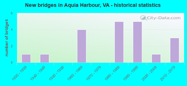
- New bridges - historical statistics
- 11930-1939
- 11940-1949
- 41960-1969
- 51980-1989
- 51990-1999
- 12000-2009
- 32010-2019


- Bridge Condition - Deck
- 50.0%Good
- 37.5%Satisfactory
- 12.5%Fair

- Bridge Condition - Superstructure
- 12.5%Very good
- 25.0%Good
- 62.5%Satisfactory

- Bridge Condition - Substructure
- 12.5%Very good
- 12.5%Good
- 50.0%Satisfactory
- 25.0%Fair

- Bridge Condition - Channel
- 10.0%Good
- 50.0%Satisfactory
- 40.0%Fair

- Bridge Condition - Culverts
- 60.0%Satisfactory
- 40.0%Fair
Find on map >> Show street view
Structure Number: 2VA00AA, Location: 1 KM SE OF CAMP BARRETT (Lat: 38.491100, Lng: -77.434250), Route carried "on" structure: Other road , Year Built: 1947, Year Reconstructed: 1993, Status: Open, Structure Length: 2.33m (7.64ft), Average Daily Traffic: 2,000 (year 2015), Truck Traffic: 10%, Average Future Daily Traffic: 2,500 (year 2039), Design Load: HS 20+Mod, Features Intersected: AQUIA CREEK, Facility Carried by Structure: MCB-3
Minimum Vertical Clearance: 30+ m (98+ ft), Kilometerpoint: 0.000, Lanes on structure: 2, Owner: Navy/Marines, Approaching Roadway Width: 6.1m (20.0ft), Material/Design: Prestressed concrete, Design/Construction: Box Beam or Girders - Multiple, Number Of Spans In Main Unit: 1, Length of Maximum Span: 23.3m (76.4ft), Curb-To-Curb Width: 7.5m (24.6ft), Out-to-Out Width: 8.5m (27.9ft)
Condition: Deck: Fair, Superstructure: Good, Substructure: Fair, Channel: Good, Inventory Rating: 47.2 metric tons, Method Used To Determine Inventory Rating: Load Factor (LF), Structural Evaluation: Somewhat better than minimum adequacy, Deck Geometry: Meets minimum limits, Waterway Adequacy: Better than present minimum criteria, Approach Roadway Alignment: Equal to present minimum criteria, Length Of Structure Improvement: 2.30m (7.55ft), Designated Inspection Frequency: Every 24 months, Inspection Date: September 2021, Bridge Improvement Cost: $33,000, Roadway Improvement Cost: $66,000, Total Project Cost: $99,000 ( Estimate for 2021), Deck Structure Type: Concrete Precast Panels, Wearing Surface/Protective System: Wearing Surface: Bituminous
Find on map >> Show street view
Structure Number: 1805, Location: 5.9M PR.WM.-9.9M FRDBURG (Lat: 38.446778, Lng: -77.402367), Route carried "on" structure: US 1, Year Built: 1984, Status: Open, Structure Length: 1.34m (4.40ft), Average Daily Traffic: 7,092 (year 2020), Truck Traffic: 2%, Average Future Daily Traffic: 9,929 (year 2040), Design Load: HS 20+Mod, Features Intersected: AUSTIN RUN, Facility Carried by Structure: SBL JEFF DAVIS HWY
Minimum Vertical Clearance: 30+ m (98+ ft), Kilometerpoint: 255.126, Lanes on structure: 2, Base Highway Network: Yes, Owner: State Highway Agency, Approaching Roadway Width: 7.3m (24.0ft), Skew: 1 degrees, Material/Design: Concrete, Design/Construction: Culvert, Number Of Spans In Main Unit: 4, Length of Maximum Span: 3.0m (9.8ft)
Condition: Channel: Fair, Culverts: Satisfactory, Operating Rating: 44.5 metric tons, Method Used To Determine Operating Rating: Field evaluation and documented engineering judgment, Inventory Rating: 32.7 metric tons, Method Used To Determine Inventory Rating: Field evaluation and documented engineering judgment, Structural Evaluation: Equal to present minimum criteria, Waterway Adequacy: Equal to present minimum criteria, Approach Roadway Alignment: Equal to present desirable criteria, Designated Inspection Frequency: Every 24 months, Inspection Date: October 2020
Find on map >> Show street view
Structure Number: 18051, Location: 6.0M PR.WM.-9.9M FRDBURG (Lat: 38.446294, Lng: -77.401967), Route carried "on" structure: US 1, Year Built: 1933, Status: Open, Structure Length: 1.31m (4.30ft), Average Daily Traffic: 7,092 (year 2020), Truck Traffic: 2%, Average Future Daily Traffic: 9,929 (year 2040), Design Load: H 15, Features Intersected: AUSTIN RUN
Minimum Vertical Clearance: 30+ m (98+ ft), Kilometerpoint: 255.078, Lanes on structure: 2, Base Highway Network: Yes, Owner: State Highway Agency, Approaching Roadway Width: 6.7m (22.0ft), Material/Design: Concrete, Design/Construction: Tee Beam, Number Of Spans In Main Unit: 1, Length of Maximum Span: 12.8m (42.0ft), Curb-To-Curb Width: 7.0m (23.0ft), Out-to-Out Width: 7.6m (24.9ft)
Condition: Deck: Satisfactory, Superstructure: Satisfactory, Substructure: Satisfactory, Channel: Fair, Operating Rating: 56.2 metric tons, Method Used To Determine Operating Rating: Load Testing, Inventory Rating: 33.7 metric tons, Method Used To Determine Inventory Rating: Load Testing, Structural Evaluation: Equal to present minimum criteria, Deck Geometry: High priority of replacement, Waterway Adequacy: Equal to present minimum criteria, Approach Roadway Alignment: Equal to present desirable criteria, Length Of Structure Improvement: 1.25m (4.10ft), Designated Inspection Frequency: Every 24 months, Inspection Date: October 2020, Bridge Improvement Cost: $25,000, Roadway Improvement Cost: $5,000, Total Project Cost: $30,000, Deck Structure Type: Concrete Cast-file-Place, Wearing Surface/Protective System: Wearing Surface: Bituminous
Find on map >> Show street view
Structure Number: 18091, Location: 1.7M RTE610-2.7M PR.WM.CL (Lat: 38.485569, Lng: -77.392464), Route carried "on" structure: Interstate 95, Year Built: 1963, Status: Open, Structure Length: 4.85m (15.91ft), Average Daily Traffic: 62,590 (year 2020), Truck Traffic: 10%, Average Future Daily Traffic: 87,626 (year 2040), Design Load: HS 20+Mod, Features Intersected: AQUIA CREEK
Minimum Vertical Clearance: 30+ m (98+ ft), Kilometerpoint: 234.286, Lanes on structure: 3, Base Highway Network: Yes, Owner: State Highway Agency, Approaching Roadway Width: 11.0m (36.1ft), Material/Design: Steel, Design/Construction: Stringer/Multi-beam, Number Of Spans In Main Unit: 3, Length of Maximum Span: 16.5m (54.1ft), Curb or Sidewalk Widths: Left: 0.2m (0.7ft), Right: 0.2m (0.7ft), Curb-To-Curb Width: 19.7m (64.6ft), Out-to-Out Width: 20.7m (67.9ft)
Condition: Deck: Good, Superstructure: Satisfactory, Substructure: Satisfactory, Channel: Satisfactory, Operating Rating: 49.0 metric tons, Method Used To Determine Operating Rating: Load and Resistance Factor (LRFR), Inventory Rating: 37.2 metric tons, Method Used To Determine Inventory Rating: Load and Resistance Factor (LRFR), Structural Evaluation: Equal to present minimum criteria, Deck Geometry: Superior to present desirable criteria, Waterway Adequacy: Superior to present desirable criteria, Approach Roadway Alignment: Equal to present desirable criteria, Designated Inspection Frequency: Every 24 months, Inspection Date: October 2020, Deck Structure Type: Concrete Cast-file-Place, Wearing Surface/Protective System: Wearing Surface: Latex Concrete
Find on map >> Show street view
Structure Number: 18092, Location: 1.7M RTE610-2.7M PR.WM.CO (Lat: 38.485225, Lng: -77.391858), Route carried "on" structure: Interstate 95, Year Built: 1963, Status: Open, Structure Length: 4.85m (15.91ft), Average Daily Traffic: 64,595 (year 2020), Truck Traffic: 10%, Average Future Daily Traffic: 90,433 (year 2040), Design Load: HS 20+Mod, Features Intersected: AQUIA CREEK
Minimum Vertical Clearance: 30+ m (98+ ft), Kilometerpoint: 234.061, Lanes on structure: 3, Base Highway Network: Yes, Owner: State Highway Agency, Approaching Roadway Width: 11.0m (36.1ft), Material/Design: Steel, Design/Construction: Stringer/Multi-beam, Number Of Spans In Main Unit: 3, Length of Maximum Span: 16.5m (54.1ft), Curb or Sidewalk Widths: Left: 0.2m (0.7ft), Right: 0.2m (0.7ft), Curb-To-Curb Width: 19.7m (64.6ft), Out-to-Out Width: 20.7m (67.9ft)
Condition: Deck: Good, Superstructure: Satisfactory, Substructure: Satisfactory, Channel: Satisfactory, Operating Rating: 49.0 metric tons, Method Used To Determine Operating Rating: Load and Resistance Factor (LRFR), Inventory Rating: 37.2 metric tons, Method Used To Determine Inventory Rating: Load and Resistance Factor (LRFR), Structural Evaluation: Equal to present minimum criteria, Deck Geometry: Superior to present desirable criteria, Waterway Adequacy: Superior to present desirable criteria, Approach Roadway Alignment: Equal to present desirable criteria, Designated Inspection Frequency: Every 24 months, Inspection Date: October 2020, Deck Structure Type: Concrete Cast-file-Place, Wearing Surface/Protective System: Wearing Surface: Latex Concrete
Find on map >> Show street view
Structure Number: 18107, Location: 2.1M RTE630-1.1M RTE610 (Lat: 38.448989, Lng: -77.407269), Route carried "on" structure: Interstate 95, Year Built: 1964, Status: Open, Structure Length: 0.70m (2.30ft), Average Daily Traffic: 58,902 (year 2020), Truck Traffic: 10%, Average Future Daily Traffic: 82,463 (year 2040), Design Load: HS 20, Features Intersected: AUSTIN RUN
Minimum Vertical Clearance: 30+ m (98+ ft), Kilometerpoint: 229.604, Lanes on structure: 3, Base Highway Network: Yes, Owner: State Highway Agency, Approaching Roadway Width: 17.1m (56.1ft), Skew: 12 degrees, Material/Design: Concrete, Design/Construction: Culvert, Number Of Spans In Main Unit: 2, Length of Maximum Span: 3.0m (9.8ft)
Condition: Channel: Satisfactory, Culverts: Satisfactory, Operating Rating: 89.8 metric tons, Method Used To Determine Operating Rating: Field evaluation and documented engineering judgment, Inventory Rating: 89.8 metric tons, Method Used To Determine Inventory Rating: Field evaluation and documented engineering judgment, Structural Evaluation: Equal to present minimum criteria, Waterway Adequacy: Superior to present desirable criteria, Approach Roadway Alignment: Equal to present desirable criteria, Designated Inspection Frequency: Every 24 months, Inspection Date: October 2021
Find on map >> Show street view
Structure Number: 18108, Location: 2.1M RTE630-1.1M RTE610 (Lat: 38.449853, Lng: -77.408792), Route carried "on" structure: Interstate 95, Year Built: 1964, Status: Open, Structure Length: 0.67m (2.20ft), Average Daily Traffic: 59,917 (year 2020), Truck Traffic: 10%, Average Future Daily Traffic: 83,884 (year 2040), Design Load: HS 20, Features Intersected: AUSTIN RUN
Minimum Vertical Clearance: 30+ m (98+ ft), Kilometerpoint: 229.894, Lanes on structure: 3, Base Highway Network: Yes, Owner: State Highway Agency, Approaching Roadway Width: 17.1m (56.1ft), Skew: 12 degrees, Material/Design: Concrete, Design/Construction: Culvert, Number Of Spans In Main Unit: 2, Length of Maximum Span: 3.4m (11.2ft)
Condition: Channel: Fair, Culverts: Fair, Operating Rating: 89.8 metric tons, Method Used To Determine Operating Rating: Field evaluation and documented engineering judgment, Inventory Rating: 89.8 metric tons, Method Used To Determine Inventory Rating: Field evaluation and documented engineering judgment, Structural Evaluation: Somewhat better than minimum adequacy, Waterway Adequacy: Superior to present desirable criteria, Approach Roadway Alignment: Equal to present desirable criteria, Designated Inspection Frequency: Every 24 months, Inspection Date: October 2021
Find on map >> Show street view
Structure Number: 18133, Location: 0.1M RTE1-5.0M RTE684 (Lat: 38.465550, Lng: -77.408453), Route carried "on" structure: County highway 610, Year Built: 1985, Year Reconstructed: 1991, Status: Open, Structure Length: 14.81m (48.59ft), Average Daily Traffic: 33,156 (year 2020), Truck Traffic: 1%, Average Future Daily Traffic: 46,420 (year 2040), Design Load: HS 20+Mod, Features Intersected: ROUTE I-95 N&SBL
Minimum Vertical Clearance: 30+ m (98+ ft), Kilometerpoint: 17.281, Lanes on structure: 5, Lanes under structure: 10, Base Highway Network: Yes, Owner: State Highway Agency, Approaching Roadway Width: 14.6m (47.9ft), Skew: 1 degrees, Material/Design: Steel continuous, Design/Construction: Stringer/Multi-beam, Number Of Spans In Main Unit: 5, Length of Maximum Span: 36.3m (119.1ft), Curb-To-Curb Width: 19.2m (63.0ft), Out-to-Out Width: 20.1m (65.9ft)
Condition: Deck: Satisfactory, Superstructure: Satisfactory, Substructure: Fair, Operating Rating: 75.2 metric tons, Method Used To Determine Operating Rating: Load and Resistance Factor (LRFR), Inventory Rating: 58.1 metric tons, Method Used To Determine Inventory Rating: Load and Resistance Factor (LRFR), Structural Evaluation: Somewhat better than minimum adequacy, Deck Geometry: Meets minimum limits, Underclear: Meets minimum limits, Approach Roadway Alignment: Equal to present desirable criteria, Designated Inspection Frequency: Every 24 months, Inspection Date: October 2020, Deck Structure Type: Concrete Cast-file-Place, Wearing Surface/Protective System: Wearing Surface: Monolithic Concrete, Deck Protection: Epoxy Coated Reinforcing
Find on map >> Show street view
Structure Number: 23308, Location: 0.1M RTE1-0.5M RTE684 (Lat: 38.465672, Lng: -77.408317), Route carried "on" structure: County highway 610, Year Built: 1991, Status: Open, Structure Length: 14.81m (48.59ft), Average Daily Traffic: 33,156 (year 2020), Truck Traffic: 1%, Average Future Daily Traffic: 46,420 (year 2040), Design Load: HS 20+Mod, Features Intersected: ROUTE 0095 N&SBL
Minimum Vertical Clearance: 30+ m (98+ ft), Kilometerpoint: 17.265, Lanes on structure: 3, Lanes under structure: 10, Owner: State Highway Agency, Approaching Roadway Width: 11.0m (36.1ft), Skew: 1 degrees, Material/Design: Steel continuous, Design/Construction: Stringer/Multi-beam, Number Of Spans In Main Unit: 5, Length of Maximum Span: 36.3m (119.1ft), Curb-To-Curb Width: 15.5m (50.9ft), Out-to-Out Width: 16.4m (53.8ft)
Condition: Deck: Satisfactory, Superstructure: Satisfactory, Substructure: Satisfactory, Operating Rating: 69.3 metric tons, Method Used To Determine Operating Rating: Load and Resistance Factor (LRFR), Inventory Rating: 53.4 metric tons, Method Used To Determine Inventory Rating: Load and Resistance Factor (LRFR), Structural Evaluation: Equal to present minimum criteria, Deck Geometry: Equal to present minimum criteria, Underclear: Somewhat better than minimum adequacy, Approach Roadway Alignment: Equal to present desirable criteria, Designated Inspection Frequency: Every 24 months, Inspection Date: October 2020, Deck Structure Type: Concrete Cast-file-Place, Wearing Surface/Protective System: Wearing Surface: Monolithic Concrete, Deck Protection: Epoxy Coated Reinforcing
Find on map >> Show street view
Structure Number: 25237, Location: 0.7M RTE610-0.4M RTE1482 (Lat: 38.462614, Lng: -77.421481), Route carried "on" structure: County highway 684, Year Built: 1997, Status: Open, Structure Length: 1.37m (4.49ft), Average Daily Traffic: 15,192 (year 2020), Average Future Daily Traffic: 21,269 (year 2040), Design Load: HS 20, Features Intersected: TRIB. OF AUSTIN RUN, Facility Carried by Structure: MINE RD.
Minimum Vertical Clearance: 30+ m (98+ ft), Kilometerpoint: 1.110, Lanes on structure: 4, Owner: State Highway Agency, Approaching Roadway Width: 19.1m (62.7ft), Skew: 22 degrees, Material/Design: Concrete, Design/Construction: Culvert, Number Of Spans In Main Unit: 5, Length of Maximum Span: 1.5m (4.9ft)
Condition: Channel: Fair, Culverts: Fair, Operating Rating: 44.5 metric tons, Method Used To Determine Operating Rating: Field evaluation and documented engineering judgment, Inventory Rating: 32.7 metric tons, Method Used To Determine Inventory Rating: Field evaluation and documented engineering judgment, Structural Evaluation: Somewhat better than minimum adequacy, Waterway Adequacy: Superior to present desirable criteria, Approach Roadway Alignment: Equal to present desirable criteria, Designated Inspection Frequency: Every 24 months, Inspection Date: November 2021
Find on map >> Show street view
Structure Number: 28807, Location: 3.8M PR.WM.-12.2M FRBURG (Lat: 38.474178, Lng: -77.394803), Route carried "on" structure: US 1, Year Built: 2014, Status: Open, Structure Length: 2.76m (9.06ft), Average Daily Traffic: 19,698 (year 2020), Truck Traffic: 2%, Average Future Daily Traffic: 27,577 (year 2040), Design Load: HS 20, Features Intersected: AQUIA CREEK, Facility Carried by Structure: JEFFERSON DAVIS HY
Minimum Vertical Clearance: 30+ m (98+ ft), Kilometerpoint: 0.000, Lanes on structure: 4, Base Highway Network: Yes, Owner: State Highway Agency, Approaching Roadway Width: 14.6m (47.9ft), Material/Design: Prestressed concrete, Design/Construction: Stringer/Multi-beam, Number Of Spans In Main Unit: 1, Length of Maximum Span: 26.4m (86.6ft), Curb-To-Curb Width: 29.3m (96.1ft), Out-to-Out Width: 30.0m (98.4ft)
Condition: Deck: Good, Superstructure: Very good, Substructure: Very good, Channel: Satisfactory, Operating Rating: 74.9 metric tons, Method Used To Determine Operating Rating: Load and Resistance Factor (LRFR), Inventory Rating: 55.9 metric tons, Method Used To Determine Inventory Rating: Load and Resistance Factor (LRFR), Structural Evaluation: Equal to present desirable criteria, Deck Geometry: Superior to present desirable criteria, Waterway Adequacy: Equal to present minimum criteria, Approach Roadway Alignment: Equal to present desirable criteria, Designated Inspection Frequency: Every 24 months, Inspection Date: October 2020, Deck Structure Type: Concrete Cast-file-Place, Wearing Surface/Protective System: Wearing Surface: Monolithic Concrete, Deck Protection: Galvanized Reinforcing
Find on map >> Show street view
Structure Number: 2997, Location: 1.1M Rt610-3.3M PWCL (Lat: 38.479889, Lng: -77.397222), Route carried "on" structure: Ramp Interstate 95, Year Built: 2014, Status: Open, Structure Length: 13.66m (44.82ft), Average Daily Traffic: 68,352 (year 2018), Truck Traffic: 10%, Average Future Daily Traffic: 220,000 (year 2035), Design Load: HL 93, Features Intersected: I-95 SBL
Minimum Vertical Clearance: 30.18m (99.02ft), Kilometerpoint: 0.000, Lanes on structure: 1, Lanes under structure: 3, Base Highway Network: Yes, Toll: On toll road, Owner: State Highway Agency, Approaching Roadway Width: 9.1m (29.9ft), Material/Design: Steel, Design/Construction: Stringer/Multi-beam, Number Of Spans In Main Unit: 2, Length of Maximum Span: 73.8m (242.1ft), Curb-To-Curb Width: 9.1m (29.9ft), Out-to-Out Width: 10.2m (33.5ft)
Condition: Deck: Good, Superstructure: Good, Substructure: Good, Operating Rating: 71.1 metric tons, Method Used To Determine Operating Rating: Load and Resistance Factor (LRFR), Inventory Rating: 54.8 metric tons, Method Used To Determine Inventory Rating: Load and Resistance Factor (LRFR), Structural Evaluation: Better than present minimum criteria, Deck Geometry: Superior to present desirable criteria, Underclear: Equal to present minimum criteria, Approach Roadway Alignment: Equal to present desirable criteria, Designated Inspection Frequency: Every 24 months, Inspection Date: October 2020, Deck Structure Type: Concrete Cast-file-Place
Find on map >> Show street view
Structure Number: 30475, Location: 0.1M Rt1 -0.1M to Rt2202 (Lat: 38.470083, Lng: -77.397306), Route carried "on" structure: State highway 2200, Year Built: 2006, Status: Open, Structure Length: 0.98m (3.22ft), Average Daily Traffic: 100 (year 2013), Truck Traffic: 1%, Average Future Daily Traffic: 400 (year 2035), Design Load: HS 20+Mod, Features Intersected: STREAM, Facility Carried by Structure: COACHMAN CIRCLE
Minimum Vertical Clearance: 30+ m (98+ ft), Kilometerpoint: 0.000, Lanes on structure: 2, Owner: State Highway Agency, Approaching Roadway Width: 9.8m (32.2ft), Material/Design: Steel, Design/Construction: Culvert, Number Of Spans In Main Unit: 3, Length of Maximum Span: 2.6m (8.5ft)
Condition: Channel: Satisfactory, Culverts: Satisfactory, Operating Rating: 44.5 metric tons, Method Used To Determine Operating Rating: Field evaluation and documented engineering judgment, Inventory Rating: 32.7 metric tons, Method Used To Determine Inventory Rating: Field evaluation and documented engineering judgment, Structural Evaluation: Equal to present minimum criteria, Waterway Adequacy: Equal to present desirable criteria, Approach Roadway Alignment: Equal to present desirable criteria, Designated Inspection Frequency: Every 24 months, Inspection Date: November 2021
Find on map >> Show street view
Structure Number: 18133, Location: 0.1M RTE1-5.0M RTE684 (Lat: 38.465550, Lng: -77.408453), Route carried "under" structure: Interstate 95, Year Built: 1985, Structure Length: 0. m, Average Daily Traffic: 69,985 (year 2019), Truck Traffic: 15%, Features Intersected: ROUTE I-95 N&SBL, Facility Carried by Structure: ROUTE 0610 EBL
Minimum Vertical Clearance: 4.95m (16.24ft), Kilometerpoint: 231.198, Lanes on structure: 5, Lanes under structure: 4, Material/Design: Steel continuous, Design/Construction: Stringer/Multi-beam, Length of Maximum Span: 36.3m (119.1ft)
Find on map >> Show street view
Structure Number: 18133, Location: 0.1M RTE1-5.0M RTE684 (Lat: 38.465550, Lng: -77.408453), Route carried "under" structure: Interstate 95, Year Built: 1985, Structure Length: 0. m, Features Intersected: ROUTE I-95 N&SBL, Facility Carried by Structure: ROUTE 0610 EBL
Minimum Vertical Clearance: 5.58m (18.31ft), Kilometerpoint: 231.198, Lanes on structure: 5, Lanes under structure: 2, Toll: On Interstate toll segment, Material/Design: Steel continuous, Design/Construction: Stringer/Multi-beam, Length of Maximum Span: 36.3m (119.1ft)
Find on map >> Show street view
Structure Number: 18133, Location: 0.1M RTE1-5.0M RTE684 (Lat: 38.465550, Lng: -77.408453), Route carried "under" structure: Interstate 95, Year Built: 1985, Structure Length: 0. m, Average Daily Traffic: 72,906 (year 2019), Truck Traffic: 15%, Features Intersected: ROUTE I-95 N&SBL, Facility Carried by Structure: ROUTE 0610 EBL
Minimum Vertical Clearance: 5.15m (16.90ft), Kilometerpoint: 231.198, Lanes on structure: 5, Lanes under structure: 4, Material/Design: Steel continuous, Design/Construction: Stringer/Multi-beam, Length of Maximum Span: 36.3m (119.1ft)
Find on map >> Show street view
Structure Number: 23308, Location: 0.1M RTE1-0.5M RTE684 (Lat: 38.465672, Lng: -77.408317), Route carried "under" structure: Interstate 95, Year Built: 1991, Structure Length: 0. m, Average Daily Traffic: 69,985 (year 2019), Truck Traffic: 15%, Features Intersected: ROUTE 0095 N&SBL, Facility Carried by Structure: ROUTE 0610 WBL
Minimum Vertical Clearance: 5.49m (18.01ft), Kilometerpoint: 231.037, Lanes on structure: 3, Lanes under structure: 4, Material/Design: Steel continuous, Design/Construction: Stringer/Multi-beam, Length of Maximum Span: 36.3m (119.1ft)
Find on map >> Show street view
Structure Number: 23308, Location: 0.1M RTE1-0.5M RTE684 (Lat: 38.465672, Lng: -77.408317), Route carried "under" structure: Interstate 95, Year Built: 1991, Structure Length: 0. m, Average Daily Traffic: 69,985 (year 2019), Truck Traffic: 15%, Features Intersected: ROUTE 0095 N&SBL, Facility Carried by Structure: ROUTE 0610 WBL
Minimum Vertical Clearance: 5.23m (17.16ft), Kilometerpoint: 231.102, Lanes on structure: 3, Lanes under structure: 4, Material/Design: Steel continuous, Design/Construction: Stringer/Multi-beam, Length of Maximum Span: 36.3m (119.1ft)
Find on map >> Show street view
Structure Number: 23308, Location: 0.1M RTE1-0.5M RTE684 (Lat: 38.465672, Lng: -77.408317), Route carried "under" structure: Interstate 95, Year Built: 1991, Structure Length: 0. m, Features Intersected: ROUTE 0095 N&SBL, Facility Carried by Structure: ROUTE 0610 WBL
Minimum Vertical Clearance: 5.82m (19.09ft), Kilometerpoint: 0.000, Lanes on structure: 3, Lanes under structure: 2, Toll: On Interstate toll segment, Material/Design: Steel continuous, Design/Construction: Stringer/Multi-beam, Length of Maximum Span: 36.3m (119.1ft)
Find on map >> Show street view
Structure Number: 2997, Location: 1.1M Rt610-3.3M PWCL (Lat: 38.479889, Lng: -77.397222), Route carried "under" structure: Interstate 95, Year Built: 2014, Structure Length: 0. m, Average Daily Traffic: 69,985 (year 2019), Truck Traffic: 15%, Features Intersected: I-95 SBL
Minimum Vertical Clearance: 6.05m (19.85ft), Kilometerpoint: 0.000, Lanes on structure: 1, Lanes under structure: 3, Material/Design: Steel, Design/Construction: Stringer/Multi-beam, Length of Maximum Span: 73.8m (242.1ft)