Bridge Statistics for Apple Canyon Lake, Illinois (IL)
Condition, Traffic, Stress, Structural Evaluation, Project Costs
- National Bridge Inventory (NBI) Statistics
- 20Number of bridges
- 171ft / 51.6mTotal length
- $460,000Total costs
- 4,475Total average daily traffic
- 582Total average daily truck traffic
- 7,000Total future (year 2032) average daily traffic
- National Bridge Inventory (NBI) Registered Bridges for Apple Canyon Lake
- No street view available for this location
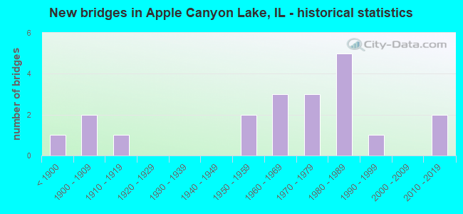
- New bridges - historical statistics
- 1Before 1900
- 21900-1909
- 11910-1919
- 21950-1959
- 31960-1969
- 31970-1979
- 51980-1989
- 11990-1999
- 22010-2019

- Bridge Condition - Deck
- 21.1%Very good
- 47.4%Good
- 15.8%Satisfactory
- 5.3%Fair
- 10.5%Poor

- Bridge Condition - Superstructure
- 21.1%Very good
- 36.8%Good
- 10.5%Satisfactory
- 15.8%Fair
- 15.8%Poor

- Bridge Condition - Substructure
- 26.3%Very good
- 36.8%Good
- 15.8%Satisfactory
- 10.5%Fair
- 10.5%Poor

- Bridge Condition - Channel
- 10.5%Very good
- 31.6%Good
- 47.4%Satisfactory
- 10.5%Fair
Find on map >> Show street view
Structure Number: 43303, Location: SCHAPVILLE (Lat: 42.397450, Lng: -90.194817), Route carried "on" structure: County highway , Year Built: 1965, Status: Open, Structure Length: 1.52m (4.99ft), Average Daily Traffic: 350 (year 2021), Truck Traffic: 21%, Average Future Daily Traffic: 450 (year 2040), Design Load: HS 15, Features Intersected: MILL CREEK, Facility Carried by Structure: E SCHAPVILLE RD
Minimum Vertical Clearance: 30+ m (98+ ft), Kilometerpoint: 6.148, Lanes on structure: 2, Owner: County Highway Agency, Approaching Roadway Width: 9.1m (29.9ft), Material/Design: Steel, Design/Construction: Stringer/Multi-beam, Number Of Spans In Main Unit: 1, Length of Maximum Span: 14.3m (46.9ft), Curb-To-Curb Width: 6.7m (22.0ft), Out-to-Out Width: 7.3m (24.0ft)
Condition: Deck: Poor, Superstructure: Satisfactory, Substructure: Satisfactory, Channel: Satisfactory, Operating Rating: 36.6 metric tons, Method Used To Determine Operating Rating: Load Factor (LF) rating reported by rating factor (RF) method using MS18 loading, Inventory Rating: 22.0 metric tons, Method Used To Determine Inventory Rating: Load Factor (LF) rating reported by rating factor (RF) method using MS18 loading, Structural Evaluation: Equal to present minimum criteria, Deck Geometry: Meets minimum limits, Waterway Adequacy: Equal to present minimum criteria, Approach Roadway Alignment: Meets minimum limits, Designated Inspection Frequency: Every 24 months, Inspection Date: April 2021, Deck Structure Type: Concrete Cast-file-Place
Find on map >> Show street view
Structure Number: 433031, Location: 1.5MI E SCHAPVILLE (Lat: 42.400122, Lng: -90.165853), Route carried "on" structure: County highway , Year Built: 1954, Status: Open, Structure Length: 2.19m (7.19ft), Average Daily Traffic: 250 (year 2021), Truck Traffic: 19%, Average Future Daily Traffic: 250 (year 2040), Design Load: H 15, Features Intersected: HELLS BRANCH APPLE R, Facility Carried by Structure: E SCHAPVILLE RD
Minimum Vertical Clearance: 30+ m (98+ ft), Kilometerpoint: 8.642, Lanes on structure: 2, Owner: County Highway Agency, Approaching Roadway Width: 7.9m (25.9ft), Material/Design: Steel continuous, Design/Construction: Stringer/Multi-beam, Number Of Spans In Main Unit: 2, Length of Maximum Span: 10.7m (35.1ft), Curb-To-Curb Width: 6.1m (20.0ft), Out-to-Out Width: 6.5m (21.3ft)
Condition: Deck: Satisfactory, Superstructure: Poor, Substructure: Poor, Channel: Good, Operating Rating: 33.4 metric tons, Method Used To Determine Operating Rating: Load Factor (LF) rating reported by rating factor (RF) method using MS18 loading, Inventory Rating: 19.8 metric tons, Method Used To Determine Inventory Rating: Load Factor (LF) rating reported by rating factor (RF) method using MS18 loading, Structural Evaluation: Meets minimum limits, Deck Geometry: Meets minimum limits, Waterway Adequacy: Equal to present desirable criteria, Approach Roadway Alignment: Better than present minimum criteria, Designated Inspection Frequency: Every 24 months, Other Special Inspection Frequency: Every 12 months, Inspection Date: March 2020, Other Special Inspection Date: August 2021, Deck Structure Type: Concrete Cast-file-Place
Find on map >> Show street view
Structure Number: 433039, Location: 5 M W APPLE RIVER (Lat: 42.498400, Lng: -90.193133), Route carried "on" structure: County highway , Year Built: 1901, Status: Open, Structure Length: 1.46m (4.79ft), Average Daily Traffic: 50 (year 2021), Average Future Daily Traffic: 50 (year 2040), Features Intersected: WEST FORK APPLE RIV, Facility Carried by Structure: TOWNSHIP ROAD NO.
Minimum Vertical Clearance: 30+ m (98+ ft), Kilometerpoint: 2.527, Lanes on structure: 1, Owner: Town or Township Highway Agency, Approaching Roadway Width: 6.1m (20.0ft), Material/Design: Concrete, Number Of Spans In Main Unit: 1, Length of Maximum Span: 14.3m (46.9ft), Curb-To-Curb Width: 5.4m (17.7ft), Out-to-Out Width: 6.7m (22.0ft)
Condition: Deck: Good, Superstructure: Fair, Substructure: Satisfactory, Channel: Satisfactory, Operating Rating: 32.4 metric tons, Method Used To Determine Operating Rating: Field evaluation and documented engineering judgment, Inventory Rating: 17.5 metric tons, Method Used To Determine Inventory Rating: Field evaluation and documented engineering judgment, Structural Evaluation: Somewhat better than minimum adequacy, Deck Geometry: High priority of corrective action, Waterway Adequacy: Equal to present minimum criteria, Approach Roadway Alignment: Meets minimum limits, Length Of Structure Improvement: 2.19m (7.19ft), Designated Inspection Frequency: Every 24 months, Inspection Date: October 2020, Bridge Improvement Cost: $93,000, Roadway Improvement Cost: $9,000, Total Project Cost: $140,000, Deck Structure Type: Concrete Cast-file-Place, Wearing Surface/Protective System: Wearing Surface: Gravel
Find on map >> Show street view
Structure Number: 433113, Location: 5 MI W STOCKTON (Lat: 42.364456, Lng: -90.123608), Route carried "on" structure: County highway , Year Built: 1967, Status: Open, Structure Length: 1.43m (4.69ft), Average Daily Traffic: 50 (year 2021), Average Future Daily Traffic: 50 (year 2040), Design Load: H 15, Features Intersected: WELSH HOLLOW, Facility Carried by Structure: TOWNSHIP RD NO 127
Minimum Vertical Clearance: 30+ m (98+ ft), Kilometerpoint: 1.030, Lanes on structure: 2, Owner: Town or Township Highway Agency, Approaching Roadway Width: 6.1m (20.0ft), Skew: 1 degrees, Material/Design: Steel, Design/Construction: Stringer/Multi-beam, Number Of Spans In Main Unit: 1, Length of Maximum Span: 13.4m (44.0ft), Curb-To-Curb Width: 6.1m (20.0ft), Out-to-Out Width: 6.9m (22.6ft)
Condition: Deck: Good, Superstructure: Good, Substructure: Good, Channel: Fair, Operating Rating: 44.1 metric tons, Method Used To Determine Operating Rating: Load Factor (LF) rating reported by rating factor (RF) method using MS18 loading, Inventory Rating: 26.6 metric tons, Method Used To Determine Inventory Rating: Load Factor (LF) rating reported by rating factor (RF) method using MS18 loading, Structural Evaluation: Equal to present minimum criteria, Deck Geometry: Somewhat better than minimum adequacy, Waterway Adequacy: Better than present minimum criteria, Approach Roadway Alignment: Equal to present minimum criteria, Designated Inspection Frequency: Every 24 months, Inspection Date: October 2020, Deck Structure Type: Concrete Cast-file-Place
Find on map >> Show street view
Structure Number: 433117, Location: 1.5 MI NO. WOODBINE (Lat: 42.364303, Lng: -90.159319), Route carried "on" structure: County highway , Year Built: 1890, Status: Closed, Structure Length: 4.36m (14.30ft), Average Daily Traffic: 50 (year 2021), Truck Traffic: 12%, Average Future Daily Traffic: 75 (year 2040), Features Intersected: APPLE RIVER, Facility Carried by Structure: S. APPLE RIVER ROA
Minimum Vertical Clearance: 4.60m (15.09ft), Kilometerpoint: 3.009, Lanes on structure: 1, Owner: Town or Township Highway Agency, Approaching Roadway Width: 6.1m (20.0ft), Material/Design: Steel, Design/Construction: Truss - Thru, Number Of Spans In Main Unit: 3, Length of Maximum Span: 33.8m (110.9ft), Curb-To-Curb Width: 3.7m (12.1ft), Out-to-Out Width: 4.3m (14.1ft)
Condition: Deck: Poor, Superstructure: Poor, Substructure: Poor, Channel: Good, Operating Rating: 3.9 metric tons, Method Used To Determine Operating Rating: Load Factor (LF) rating reported by rating factor (RF) method using MS18 loading, Inventory Rating: 2.3 metric tons, Method Used To Determine Inventory Rating: Load Factor (LF) rating reported by rating factor (RF) method using MS18 loading, Deck Geometry: Meets minimum limits, Waterway Adequacy: Equal to present minimum criteria, Approach Roadway Alignment: Meets minimum limits, Bridge Posting: Required (Relationship of Operating Rating to Maximum Legal Load: > 39.9% below), Length Of Structure Improvement: 5.24m (17.19ft), Designated Inspection Frequency: Every 24 months, Critical Feature Inspection Frequency: Every 12 months, Inspection Date: October 2018, Critical Feature Inspection Date: October 2018, Bridge Improvement Cost: $176,000, Roadway Improvement Cost: $18,000, Total Project Cost: $264,000, Deck Structure Type: Wood or Timber, Wearing Surface/Protective System: Wearing Surface: Wood or Timber
Find on map >> Show street view
Structure Number: 433124, Location: 1 MI SO SCHAPVILLE (Lat: 42.378731, Lng: -90.200792), Route carried "on" structure: County highway , Year Built: 1964, Status: Open, Structure Length: 0.94m (3.08ft), Average Daily Traffic: 125 (year 2021), Truck Traffic: 19%, Average Future Daily Traffic: 200 (year 2040), Design Load: HS 15, Features Intersected: BR OF HELLS CREEK, Facility Carried by Structure: TOWNSHIP RD NO 146
Minimum Vertical Clearance: 30+ m (98+ ft), Kilometerpoint: 2.301, Lanes on structure: 2, Owner: Town or Township Highway Agency, Approaching Roadway Width: 7.3m (24.0ft), Material/Design: Steel, Design/Construction: Stringer/Multi-beam, Number Of Spans In Main Unit: 1, Length of Maximum Span: 8.8m (28.9ft), Curb-To-Curb Width: 6.1m (20.0ft), Out-to-Out Width: 6.9m (22.6ft)
Condition: Deck: Good, Superstructure: Good, Substructure: Satisfactory, Channel: Good, Operating Rating: 58.0 metric tons, Method Used To Determine Operating Rating: Load Factor (LF) rating reported by rating factor (RF) method using MS18 loading, Inventory Rating: 35.0 metric tons, Method Used To Determine Inventory Rating: Load Factor (LF) rating reported by rating factor (RF) method using MS18 loading, Structural Evaluation: Equal to present minimum criteria, Deck Geometry: Meets minimum limits, Waterway Adequacy: Equal to present desirable criteria, Approach Roadway Alignment: Equal to present minimum criteria, Designated Inspection Frequency: Every 24 months, Inspection Date: October 2020, Deck Structure Type: Concrete Cast-file-Place, Wearing Surface/Protective System: Wearing Surface: Bituminous
Find on map >> Show street view
Structure Number: 433129, Location: 6 MI SW APPLE RIVER (Lat: 42.451239, Lng: -90.180758), Route carried "on" structure: County highway , Year Built: 1971, Status: Open, Structure Length: 1.28m (4.20ft), Average Daily Traffic: 225 (year 2021), Truck Traffic: 20%, Average Future Daily Traffic: 450 (year 2040), Design Load: HS 15, Features Intersected: HELLS BRANCH CREEK, Facility Carried by Structure: TOWNSHIP ROAD NO 1
Minimum Vertical Clearance: 30+ m (98+ ft), Kilometerpoint: 3.412, Lanes on structure: 2, Owner: Town or Township Highway Agency, Approaching Roadway Width: 4.9m (16.1ft), Skew: 1 degrees, Material/Design: Concrete, Design/Construction: Channel Beam, Number Of Spans In Main Unit: 1, Length of Maximum Span: 11.9m (39.0ft), Curb-To-Curb Width: 7.4m (24.3ft), Out-to-Out Width: 8.1m (26.6ft)
Condition: Deck: Satisfactory, Superstructure: Fair, Substructure: Good, Channel: Satisfactory, Operating Rating: 45.7 metric tons, Method Used To Determine Operating Rating: Load Factor (LF) rating reported by rating factor (RF) method using MS18 loading, Inventory Rating: 27.5 metric tons, Method Used To Determine Inventory Rating: Load Factor (LF) rating reported by rating factor (RF) method using MS18 loading, Structural Evaluation: Somewhat better than minimum adequacy, Deck Geometry: Somewhat better than minimum adequacy, Waterway Adequacy: Equal to present desirable criteria, Approach Roadway Alignment: Somewhat better than minimum adequacy, Designated Inspection Frequency: Every 24 months, Inspection Date: March 2020, Deck Structure Type: Concrete Precast Panels, Wearing Surface/Protective System: Wearing Surface: Bituminous
Find on map >> Show street view
Structure Number: 433145, Location: 5.5 MI SO APPLE RIV (Lat: 42.421803, Lng: -90.101733), Route carried "on" structure: County highway , Year Built: 1915, Status: Open, Structure Length: 0.73m (2.40ft), Average Daily Traffic: 25 (year 2021), Average Future Daily Traffic: 25 (year 2040), Features Intersected: BR COON CREEK, Facility Carried by Structure: TOWNSHIP RD NO 186
Minimum Vertical Clearance: 30+ m (98+ ft), Kilometerpoint: 8.867, Lanes on structure: 1, Owner: Town or Township Highway Agency, Approaching Roadway Width: 4.9m (16.1ft), Material/Design: Concrete, Design/Construction: Slab, Number Of Spans In Main Unit: 1, Length of Maximum Span: 7.3m (24.0ft), Curb-To-Curb Width: 5.0m (16.4ft), Out-to-Out Width: 5.4m (17.7ft)
Condition: Deck: Fair, Superstructure: Fair, Substructure: Fair, Channel: Fair, Operating Rating: 32.4 metric tons, Method Used To Determine Operating Rating: Field evaluation and documented engineering judgment, Inventory Rating: 17.5 metric tons, Method Used To Determine Inventory Rating: Field evaluation and documented engineering judgment, Structural Evaluation: Somewhat better than minimum adequacy, Deck Geometry: High priority of corrective action, Waterway Adequacy: Somewhat better than minimum adequacy, Approach Roadway Alignment: Equal to present minimum criteria, Length Of Structure Improvement: 1.31m (4.30ft), Designated Inspection Frequency: Every 24 months, Inspection Date: September 2020, Bridge Improvement Cost: $37,000, Roadway Improvement Cost: $4,000, Total Project Cost: $56,000, Deck Structure Type: Concrete Cast-file-Place, Wearing Surface/Protective System: Wearing Surface: Other
Find on map >> Show street view
Structure Number: 433207, Location: 2.0 MI N OF WOODBINE (Lat: 42.372156, Lng: -90.141375), Route carried "on" structure: County highway , Year Built: 1978, Status: Open, Structure Length: 0.85m (2.79ft), Average Daily Traffic: 50 (year 2021), Average Future Daily Traffic: 50 (year 2040), Design Load: HS 20, Features Intersected: APPLE RIVER TRIB, Facility Carried by Structure: SO APPLE RIVER ROA
Minimum Vertical Clearance: 30+ m (98+ ft), Kilometerpoint: 0.933, Lanes on structure: 2, Owner: Town or Township Highway Agency, Approaching Roadway Width: 8.5m (27.9ft), Skew: 3 degrees, Material/Design: Prestressed concrete, Design/Construction: Box Beam or Girders - Multiple, Number Of Spans In Main Unit: 1, Length of Maximum Span: 7.6m (24.9ft), Curb-To-Curb Width: 8.1m (26.6ft), Out-to-Out Width: 8.1m (26.6ft)
Condition: Deck: Good, Superstructure: Good, Substructure: Good, Channel: Good, Operating Rating: 44.4 metric tons, Method Used To Determine Operating Rating: Assigned rating based on Load Factor Design (LFD) reported by rating factor (RF) using MS18 loading, Inventory Rating: 32.4 metric tons, Method Used To Determine Inventory Rating: Assigned rating based on Load Factor Design (LFD) reported by rating factor (RF) using MS18 loading, Structural Evaluation: Better than present minimum criteria, Deck Geometry: Equal to present minimum criteria, Waterway Adequacy: Equal to present minimum criteria, Approach Roadway Alignment: Somewhat better than minimum adequacy, Designated Inspection Frequency: Every 48 months, Inspection Date: March 2019, Deck Structure Type: Concrete Precast Panels
Find on map >> Show street view
Structure Number: 43321, Location: 8MI SW APPLE RIVER (Lat: 42.415961, Lng: -90.167522), Route carried "on" structure: County highway , Year Built: 1971, Status: Open, Structure Length: 1.28m (4.20ft), Average Daily Traffic: 550 (year 2021), Truck Traffic: 11%, Average Future Daily Traffic: 1,100 (year 2040), Design Load: HS 15, Features Intersected: HELLS BRANCH, Facility Carried by Structure: S APPLE CANYONRO
Minimum Vertical Clearance: 30+ m (98+ ft), Kilometerpoint: 3.380, Lanes on structure: 2, Owner: Town or Township Highway Agency, Approaching Roadway Width: 7.3m (24.0ft), Material/Design: Concrete, Design/Construction: Slab, Number Of Spans In Main Unit: 1, Length of Maximum Span: 12.5m (41.0ft), Curb-To-Curb Width: 7.3m (24.0ft), Out-to-Out Width: 8.6m (28.2ft)
Condition: Deck: Good, Superstructure: Good, Substructure: Good, Channel: Satisfactory, Operating Rating: 42.1 metric tons, Method Used To Determine Operating Rating: Load Factor (LF) rating reported by rating factor (RF) method using MS18 loading, Inventory Rating: 25.3 metric tons, Method Used To Determine Inventory Rating: Load Factor (LF) rating reported by rating factor (RF) method using MS18 loading, Structural Evaluation: Equal to present minimum criteria, Deck Geometry: Meets minimum limits, Waterway Adequacy: Superior to present desirable criteria, Approach Roadway Alignment: Equal to present desirable criteria, Designated Inspection Frequency: Every 24 months, Inspection Date: March 2020, Deck Structure Type: Concrete Cast-file-Place, Wearing Surface/Protective System: Wearing Surface: Bituminous
Find on map >> Show street view
Structure Number: 433223, Location: 4.25 MI N WOODBINE (Lat: 42.404767, Lng: -90.117200), Route carried "on" structure: County highway , Year Built: 1981, Year Reconstructed: 1996, Status: Open, Structure Length: 5.55m (18.21ft), Average Daily Traffic: 650 (year 2021), Truck Traffic: 10%, Average Future Daily Traffic: 1,300 (year 2040), Design Load: HS 20, Features Intersected: APPLE RIVER, Facility Carried by Structure: E TOWNSEND ROAD
Minimum Vertical Clearance: 30+ m (98+ ft), Kilometerpoint: 1.336, Lanes on structure: 2, Owner: Town or Township Highway Agency, Approaching Roadway Width: 9.1m (29.9ft), Skew: 3 degrees, Material/Design: Prestressed concrete, Design/Construction: Box Beam or Girders - Multiple, Number Of Spans In Main Unit: 3, Length of Maximum Span: 18.3m (60.0ft), Curb-To-Curb Width: 8.5m (27.9ft), Out-to-Out Width: 8.6m (28.2ft)
Condition: Deck: Good, Superstructure: Good, Substructure: Very good, Channel: Satisfactory, Operating Rating: 44.4 metric tons, Method Used To Determine Operating Rating: Assigned rating based on Load Factor Design (LFD) reported by rating factor (RF) using MS18 loading, Inventory Rating: 32.4 metric tons, Method Used To Determine Inventory Rating: Assigned rating based on Load Factor Design (LFD) reported by rating factor (RF) using MS18 loading, Structural Evaluation: Better than present minimum criteria, Deck Geometry: Somewhat better than minimum adequacy, Waterway Adequacy: Better than present minimum criteria, Approach Roadway Alignment: Equal to present minimum criteria, Designated Inspection Frequency: Every 48 months, Inspection Date: March 2019, Deck Structure Type: Concrete Precast Panels, Wearing Surface/Protective System: Wearing Surface: Bituminous
Find on map >> Show street view
Structure Number: 433225, Location: 6 M S APPLE RIVER (Lat: 42.403936, Lng: -90.127617), Route carried "on" structure: County highway , Year Built: 1982, Status: Open, Structure Length: 3.38m (11.09ft), Average Daily Traffic: 650 (year 2021), Truck Traffic: 10%, Average Future Daily Traffic: 1,200 (year 2040), Design Load: HS 20, Features Intersected: COON CREEK, Facility Carried by Structure: TOWNSEND ROAD
Minimum Vertical Clearance: 30+ m (98+ ft), Kilometerpoint: 0.451, Lanes on structure: 2, Owner: Town or Township Highway Agency, Approaching Roadway Width: 9.1m (29.9ft), Skew: 4 degrees, Material/Design: Prestressed concrete, Design/Construction: Box Beam or Girders - Multiple, Number Of Spans In Main Unit: 3, Length of Maximum Span: 11.0m (36.1ft), Curb-To-Curb Width: 9.1m (29.9ft), Out-to-Out Width: 9.1m (29.9ft)
Condition: Deck: Good, Superstructure: Good, Substructure: Good, Channel: Satisfactory, Operating Rating: 44.4 metric tons, Method Used To Determine Operating Rating: Assigned rating based on Load Factor Design (LFD) reported by rating factor (RF) using MS18 loading, Inventory Rating: 32.4 metric tons, Method Used To Determine Inventory Rating: Assigned rating based on Load Factor Design (LFD) reported by rating factor (RF) using MS18 loading, Structural Evaluation: Better than present minimum criteria, Deck Geometry: Equal to present minimum criteria, Waterway Adequacy: Better than present minimum criteria, Approach Roadway Alignment: Equal to present minimum criteria, Designated Inspection Frequency: Every 48 months, Inspection Date: March 2019, Deck Structure Type: Concrete Precast Panels, Wearing Surface/Protective System: Wearing Surface: Bituminous
Find on map >> Show street view
Structure Number: 433232, Location: 7.5 MI S APPLE RIVER (Lat: 42.385194, Lng: -90.122364), Route carried "on" structure: County highway , Year Built: 1988, Status: Open, Structure Length: 1.22m (4.00ft), Average Daily Traffic: 150 (year 2021), Truck Traffic: 20%, Average Future Daily Traffic: 200 (year 2040), Design Load: HS 20, Features Intersected: BR. OF APPLE RIVER, Facility Carried by Structure: N. SCOUT CAMP ROAD
Minimum Vertical Clearance: 30+ m (98+ ft), Kilometerpoint: 15.160, Lanes on structure: 2, Owner: County Highway Agency, Approaching Roadway Width: 8.5m (27.9ft), Material/Design: Concrete, Design/Construction: Channel Beam, Number Of Spans In Main Unit: 1, Length of Maximum Span: 11.9m (39.0ft), Curb-To-Curb Width: 8.0m (26.2ft), Out-to-Out Width: 8.0m (26.2ft)
Condition: Deck: Good, Superstructure: Poor, Substructure: Good, Channel: Satisfactory, Operating Rating: 74.2 metric tons, Method Used To Determine Operating Rating: Load Factor (LF) rating reported by rating factor (RF) method using MS18 loading, Inventory Rating: 44.4 metric tons, Method Used To Determine Inventory Rating: Load Factor (LF) rating reported by rating factor (RF) method using MS18 loading, Structural Evaluation: Meets minimum limits, Deck Geometry: Somewhat better than minimum adequacy, Waterway Adequacy: Better than present minimum criteria, Approach Roadway Alignment: Equal to present desirable criteria, Designated Inspection Frequency: Every 24 months, Other Special Inspection Frequency: Every 12 months, Inspection Date: March 2020, Other Special Inspection Date: March 2021, Deck Structure Type: Concrete Cast-file-Place
Find on map >> Show street view
Structure Number: 433237, Location: 5.75 MI N ELIZABETH (Lat: 42.404250, Lng: -90.201836), Route carried "on" structure: County highway , Year Built: 1986, Status: Open, Structure Length: 3.69m (12.11ft), Average Daily Traffic: 50 (year 2021), Truck Traffic: 8%, Average Future Daily Traffic: 100 (year 2040), Design Load: HS 20, Features Intersected: MILL CREEK, Facility Carried by Structure: NO MILL CREEK RD
Minimum Vertical Clearance: 30+ m (98+ ft), Kilometerpoint: 7.306, Lanes on structure: 2, Owner: Town or Township Highway Agency, Approaching Roadway Width: 7.3m (24.0ft), Skew: 4 degrees, Material/Design: Prestressed concrete, Design/Construction: Box Beam or Girders - Multiple, Number Of Spans In Main Unit: 3, Length of Maximum Span: 18.6m (61.0ft), Curb-To-Curb Width: 7.3m (24.0ft), Out-to-Out Width: 7.3m (24.0ft)
Condition: Deck: Good, Superstructure: Good, Substructure: Good, Channel: Good, Operating Rating: 44.4 metric tons, Method Used To Determine Operating Rating: Assigned rating based on Load Factor Design (LFD) reported by rating factor (RF) using MS18 loading, Inventory Rating: 32.4 metric tons, Method Used To Determine Inventory Rating: Assigned rating based on Load Factor Design (LFD) reported by rating factor (RF) using MS18 loading, Structural Evaluation: Better than present minimum criteria, Deck Geometry: Equal to present minimum criteria, Waterway Adequacy: Equal to present minimum criteria, Approach Roadway Alignment: Equal to present minimum criteria, Designated Inspection Frequency: Every 48 months, Inspection Date: March 2019, Deck Structure Type: Concrete Precast Panels, Wearing Surface/Protective System: Wearing Surface: Bituminous
Find on map >> Show street view
Structure Number: 433238, Location: 2 MI SW APPLE RIVER (Lat: 42.474108, Lng: -90.132564), Route carried "on" structure: County highway , Year Built: 1989, Status: Open, Structure Length: 3.66m (12.01ft), Average Daily Traffic: 75 (year 2021), Average Future Daily Traffic: 150 (year 2040), Design Load: HS 20, Features Intersected: W. FORK APPLE RIVER, Facility Carried by Structure: N. HOGDON RD
Minimum Vertical Clearance: 30+ m (98+ ft), Kilometerpoint: 4.603, Lanes on structure: 2, Owner: Town or Township Highway Agency, Approaching Roadway Width: 7.3m (24.0ft), Material/Design: Prestressed concrete, Design/Construction: Box Beam or Girders - Multiple, Number Of Spans In Main Unit: 2, Length of Maximum Span: 17.9m (58.7ft), Curb-To-Curb Width: 7.3m (24.0ft), Out-to-Out Width: 7.3m (24.0ft)
Condition: Deck: Very good, Superstructure: Very good, Substructure: Very good, Channel: Satisfactory, Operating Rating: 44.4 metric tons, Method Used To Determine Operating Rating: Assigned rating based on Load Factor Design (LFD) reported by rating factor (RF) using MS18 loading, Inventory Rating: 32.4 metric tons, Method Used To Determine Inventory Rating: Assigned rating based on Load Factor Design (LFD) reported by rating factor (RF) using MS18 loading, Structural Evaluation: Equal to present desirable criteria, Deck Geometry: Equal to present minimum criteria, Waterway Adequacy: Better than present minimum criteria, Approach Roadway Alignment: Equal to present minimum criteria, Designated Inspection Frequency: Every 48 months, Inspection Date: March 2019, Deck Structure Type: Concrete Precast Panels
Find on map >> Show street view
Structure Number: 433251, Location: 6 MI S APPLE RIVER (Lat: 42.401639, Lng: -90.132150), Route carried "on" structure: County highway , Year Built: 1992, Status: Open, Structure Length: 7.56m (24.80ft), Average Daily Traffic: 150 (year 2021), Truck Traffic: 20%, Average Future Daily Traffic: 200 (year 2040), Design Load: HS 20, Features Intersected: APPLE RIVER, Facility Carried by Structure: SCOUT CAMP RD(FAS7
Minimum Vertical Clearance: 30+ m (98+ ft), Kilometerpoint: 12.794, Lanes on structure: 2, Owner: County Highway Agency, Approaching Roadway Width: 6.1m (20.0ft), Material/Design: Steel continuous, Design/Construction: Stringer/Multi-beam, Number Of Spans In Main Unit: 2, Length of Maximum Span: 37.8m (124.0ft), Curb-To-Curb Width: 8.2m (26.9ft), Out-to-Out Width: 9.2m (30.2ft)
Condition: Deck: Very good, Superstructure: Very good, Substructure: Very good, Channel: Good, Operating Rating: 44.1 metric tons, Method Used To Determine Operating Rating: Assigned rating based on Load Factor Design (LFD) reported by rating factor (RF) using MS18 loading, Inventory Rating: 32.4 metric tons, Method Used To Determine Inventory Rating: Assigned rating based on Load Factor Design (LFD) reported by rating factor (RF) using MS18 loading, Structural Evaluation: Equal to present desirable criteria, Deck Geometry: Somewhat better than minimum adequacy, Waterway Adequacy: Equal to present desirable criteria, Approach Roadway Alignment: Equal to present minimum criteria, Designated Inspection Frequency: Every 24 months, Inspection Date: March 2020, Deck Structure Type: Concrete Cast-file-Place, Wearing Surface/Protective System: Membrane: Other, Deck Protection: Epoxy Coated Reinforcing
Find on map >> Show street view
Structure Number: 433269, Location: 3 MI SW APPLE RIVER (Lat: 42.475494, Lng: -90.162922), Route carried "on" structure: County highway , Year Built: 2011, Status: Open, Structure Length: 3.90m (12.80ft), Average Daily Traffic: 575 (year 2021), Truck Traffic: 10%, Average Future Daily Traffic: 650 (year 2040), Design Load: HS 20, Features Intersected: W FORK APPLE RIVER, Facility Carried by Structure: E STAGECOACH ROAD
Minimum Vertical Clearance: 30+ m (98+ ft), Kilometerpoint: 25.121, Lanes on structure: 2, Owner: County Highway Agency, Approaching Roadway Width: 9.1m (29.9ft), Material/Design: Steel, Design/Construction: Stringer/Multi-beam, Number Of Spans In Main Unit: 1, Length of Maximum Span: 38.3m (125.7ft), Curb-To-Curb Width: 9.8m (32.2ft), Out-to-Out Width: 10.4m (34.1ft)
Condition: Deck: Very good, Superstructure: Very good, Substructure: Very good, Channel: Very good, Operating Rating: 54.1 metric tons, Method Used To Determine Operating Rating: Assigned rating based on Load Factor Design (LFD) reported by rating factor (RF) using MS18 loading, Inventory Rating: 32.4 metric tons, Method Used To Determine Inventory Rating: Assigned rating based on Load Factor Design (LFD) reported by rating factor (RF) using MS18 loading, Structural Evaluation: Equal to present desirable criteria, Deck Geometry: Equal to present minimum criteria, Waterway Adequacy: Equal to present desirable criteria, Approach Roadway Alignment: Equal to present desirable criteria, Designated Inspection Frequency: Every 24 months, Inspection Date: October 2020, Deck Structure Type: Concrete Cast-file-Place, Wearing Surface/Protective System: Membrane: Built-up, Deck Protection: Epoxy Coated Reinforcing
Find on map >> Show street view
Structure Number: 433276, Location: 5 MILES NE ELIZABETH (Lat: 42.360119, Lng: -90.144939), Route carried "on" structure: County highway , Year Built: 2012, Status: Open, Structure Length: 2.54m (8.33ft), Average Daily Traffic: 150 (year 2021), Truck Traffic: 20%, Average Future Daily Traffic: 200 (year 2032), Design Load: HS 20, Features Intersected: BRANCH OF APPLE RIVE, Facility Carried by Structure: S SCOUT CAMP ROAD
Minimum Vertical Clearance: 30+ m (98+ ft), Kilometerpoint: 19.022, Lanes on structure: 2, Owner: County Highway Agency, Approaching Roadway Width: 6.7m (22.0ft), Material/Design: Prestressed concrete, Design/Construction: Box Beam or Girders - Multiple, Number Of Spans In Main Unit: 1, Length of Maximum Span: 24.7m (81.0ft), Curb-To-Curb Width: 10.7m (35.1ft), Out-to-Out Width: 11.0m (36.1ft)
Condition: Deck: Very good, Superstructure: Very good, Substructure: Very good, Channel: Very good, Operating Rating: 44.1 metric tons, Method Used To Determine Operating Rating: Assigned rating based on Load Factor Design (LFD) reported by rating factor (RF) using MS18 loading, Inventory Rating: 32.4 metric tons, Method Used To Determine Inventory Rating: Assigned rating based on Load Factor Design (LFD) reported by rating factor (RF) using MS18 loading, Structural Evaluation: Equal to present desirable criteria, Deck Geometry: Better than present minimum criteria, Waterway Adequacy: Superior to present desirable criteria, Approach Roadway Alignment: Equal to present minimum criteria, Designated Inspection Frequency: Every 48 months, Inspection Date: Febuary 2022, Deck Structure Type: Concrete Precast Panels, Wearing Surface/Protective System: Wearing Surface: Integral Concrete, Membrane: Built-up, Deck Protection: Epoxy Coated Reinforcing
Find on map >> Show street view
Structure Number: 435002, Location: 5 MI N WOODBINE (Lat: 42.399350, Lng: -90.160200), Route carried "on" structure: County highway , Year Built: 1953, Status: Open, Structure Length: 0.91m (2.99ft), Average Daily Traffic: 250 (year 2021), Truck Traffic: 19%, Average Future Daily Traffic: 250 (year 2040), Features Intersected: BR OF HELLS BR, Facility Carried by Structure: CH 15
Minimum Vertical Clearance: 30+ m (98+ ft), Kilometerpoint: 9.125, Lanes on structure: 2, Owner: County Highway Agency, Approaching Roadway Width: 7.9m (25.9ft), Material/Design: Steel, Design/Construction: Culvert, Number Of Spans In Main Unit: 3, Length of Maximum Span: 3.0m (9.8ft)
Condition: Channel: Satisfactory, Culverts: Fair, Operating Rating: 40.5 metric tons, Method Used To Determine Operating Rating: Field evaluation and documented engineering judgment, Inventory Rating: 24.3 metric tons, Method Used To Determine Inventory Rating: Field evaluation and documented engineering judgment, Structural Evaluation: Somewhat better than minimum adequacy, Waterway Adequacy: Better than present minimum criteria, Approach Roadway Alignment: Equal to present minimum criteria, Designated Inspection Frequency: Every 24 months, Inspection Date: March 2020
Find on map >> Show street view
Structure Number: 439905, Location: 3 MI W APPLE RIVER (Lat: 42.500228, Lng: -90.163203), Route carried "on" structure: County highway , Year Built: 1901, Status: Posted for load, Structure Length: 3.11m (10.20ft), Average Daily Traffic: 50 (year 2021), Average Future Daily Traffic: 50 (year 2040), Features Intersected: CN RR, Facility Carried by Structure: ROBERTS RD
Minimum Vertical Clearance: 30+ m (98+ ft), Kilometerpoint: 5.327, Lanes on structure: 1, Owner: Railroad, Approaching Roadway Width: 5.5m (18.0ft), Material/Design: Wood or Timber, Design/Construction: Stringer/Multi-beam, Number Of Spans In Main Unit: 5, Length of Maximum Span: 6.1m (20.0ft), Curb-To-Curb Width: 5.5m (18.0ft), Out-to-Out Width: 5.9m (19.4ft)
Condition: Deck: Satisfactory, Superstructure: Satisfactory, Substructure: Fair, Operating Rating: 17.5 metric tons, Method Used To Determine Operating Rating: Allowable Stress (AS) rating reported by rating factor (RF) method using MS18 loading, Inventory Rating: 11.7 metric tons, Method Used To Determine Inventory Rating: Allowable Stress (AS) rating reported by rating factor (RF) method using MS18 loading, Structural Evaluation: Meets minimum limits, Deck Geometry: Meets minimum limits, Underclear: Somewhat better than minimum adequacy, Approach Roadway Alignment: Meets minimum limits, Bridge Posting: Required (Relationship of Operating Rating to Maximum Legal Load: > 39.9% below), Designated Inspection Frequency: Every 24 months, Inspection Date: March 2020, Deck Structure Type: Wood or Timber, Wearing Surface/Protective System: Wearing Surface: Bituminous