Bridge Statistics for Angier, North Carolina (NC)
Condition, Traffic, Stress, Structural Evaluation, Project Costs
- National Bridge Inventory (NBI) Statistics
- 13Number of bridges
- 102ft / 30.6mTotal length
- 72,100Total average daily traffic
- 12,603Total average daily truck traffic
- National Bridge Inventory (NBI) Registered Bridges for Angier
- No street view available for this location
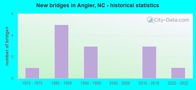
- New bridges - historical statistics
- 11970-1979
- 51980-1989
- 31990-1999
- 32010-2019
- 12020-2022


- Bridge Condition - Deck
- 12.5%Excellent
- 37.5%Very good
- 37.5%Good
- 12.5%Satisfactory

- Bridge Condition - Superstructure
- 12.5%Excellent
- 50.0%Very good
- 25.0%Good
- 12.5%Satisfactory

- Bridge Condition - Substructure
- 12.5%Excellent
- 25.0%Very good
- 37.5%Good
- 25.0%Satisfactory

- Bridge Condition - Channel
- 80.0%Good
- 20.0%Satisfactory

- Bridge Condition - Culverts
- 33.3%Satisfactory
- 66.7%Fair
Find on map >> Show street view
Structure Number: 850002, Location: 0.2 MI.W.JCT.SR1446 (Lat: 35.514533, Lng: -78.786108), Route carried "on" structure: State highway 1441, Year Built: 1989, Status: Open, Structure Length: 3.87m (12.70ft), Average Daily Traffic: 2,300 (year 2019), Truck Traffic: 6%, Average Future Daily Traffic: 4,600 (year 2040), Design Load: HS 20+Mod, Features Intersected: KENNETH CREEK
Minimum Vertical Clearance: 30+ m (98+ ft), Kilometerpoint: 0.000, Lanes on structure: 2, Owner: State Highway Agency, Approaching Roadway Width: 7.3m (24.0ft), Skew: 1 degrees, Material/Design: Prestressed concrete, Design/Construction: Slab, Number Of Spans In Main Unit: 3, Length of Maximum Span: 13.4m (44.0ft), Curb-To-Curb Width: 9.1m (29.9ft), Out-to-Out Width: 10.0m (32.8ft)
Condition: Deck: Good, Superstructure: Good, Substructure: Good, Channel: Satisfactory, Operating Rating: 89.8 metric tons, Method Used To Determine Operating Rating: Load Factor (LF), Inventory Rating: 57.1 metric tons, Method Used To Determine Inventory Rating: Load Factor (LF), Structural Evaluation: Better than present minimum criteria, Deck Geometry: Meets minimum limits, Waterway Adequacy: Equal to present minimum criteria, Approach Roadway Alignment: Equal to present desirable criteria, Designated Inspection Frequency: Every 24 months, Inspection Date: Febuary 2021, Deck Structure Type: Concrete Precast Panels, Wearing Surface/Protective System: Wearing Surface: Bituminous
Find on map >> Show street view
Structure Number: 850003, Location: 0.4 MI.E.JCT.SR1448 (Lat: 35.514225, Lng: -78.765058), Route carried "on" structure: State highway 1441, Year Built: 2014, Status: Open, Structure Length: 3.13m (10.27ft), Average Daily Traffic: 2,300 (year 2018), Truck Traffic: 7%, Average Future Daily Traffic: 4,600 (year 2040), Design Load: HL 93, Features Intersected: NEILS CREEK
Minimum Vertical Clearance: 30+ m (98+ ft), Kilometerpoint: 0.000, Lanes on structure: 2, Owner: State Highway Agency, Approaching Roadway Width: 7.0m (23.0ft), Material/Design: Prestressed concrete, Design/Construction: Slab, Number Of Spans In Main Unit: 3, Length of Maximum Span: 11.5m (37.7ft), Curb-To-Curb Width: 9.1m (29.9ft), Out-to-Out Width: 10.0m (32.8ft)
Condition: Deck: Very good, Superstructure: Very good, Substructure: Good, Channel: Good, Operating Rating: 49.8 metric tons, Method Used To Determine Operating Rating: Load and Resistance Factor (LRFR), Inventory Rating: 38.1 metric tons, Method Used To Determine Inventory Rating: Load and Resistance Factor (LRFR), Structural Evaluation: Better than present minimum criteria, Deck Geometry: Meets minimum limits, Waterway Adequacy: Better than present minimum criteria, Approach Roadway Alignment: Equal to present desirable criteria, Designated Inspection Frequency: Every 24 months, Inspection Date: Febuary 2021, Deck Structure Type: Concrete Cast-file-Place, Wearing Surface/Protective System: Wearing Surface: Bituminous, Deck Protection: Epoxy Coated Reinforcing
Find on map >> Show street view
Structure Number: 850014, Location: 0.6MI.S. OF JCT.SR1500 (Lat: 35.487211, Lng: -78.700706), Route carried "on" structure: State highway 1006, Year Built: 1994, Status: Open, Structure Length: 0.76m (2.49ft), Average Daily Traffic: 1,900 (year 2017), Truck Traffic: 7%, Average Future Daily Traffic: 3,800 (year 2040), Design Load: HS 20+Mod, Features Intersected: BLACK RIVER
Minimum Vertical Clearance: 30+ m (98+ ft), Kilometerpoint: 0.000, Lanes on structure: 2, Owner: State Highway Agency, Approaching Roadway Width: 6.0m (19.7ft), Material/Design: Concrete continuous, Design/Construction: Culvert, Number Of Spans In Main Unit: 2, Length of Maximum Span: 3.6m (11.8ft)
Condition: Channel: Satisfactory, Culverts: Satisfactory, Operating Rating: 51.7 metric tons, Method Used To Determine Operating Rating: Load and Resistance Factor (LRFR), Inventory Rating: 30.8 metric tons, Method Used To Determine Inventory Rating: Load and Resistance Factor (LRFR), Structural Evaluation: Equal to present minimum criteria, Waterway Adequacy: Better than present minimum criteria, Approach Roadway Alignment: Equal to present desirable criteria, Designated Inspection Frequency: Every 24 months, Underwater Inspection Frequency: Every 60 months, Inspection Date: June 2020, Underwater Inspection Date: June 2020
Find on map >> Show street view
Structure Number: 850204, Location: 0.5 MI.N.SR1542 (Lat: 35.455636, Lng: -78.755228), Route carried "on" structure: State highway 1510, Year Built: 1994, Status: Open, Structure Length: 2.80m (9.19ft), Average Daily Traffic: 750 (year 2016), Truck Traffic: 6%, Average Future Daily Traffic: 1,500 (year 2040), Design Load: HS 20+Mod, Features Intersected: W.BUIES CREEK
Minimum Vertical Clearance: 30+ m (98+ ft), Kilometerpoint: 0.000, Lanes on structure: 2, Owner: State Highway Agency, Approaching Roadway Width: 5.4m (17.7ft), Material/Design: Prestressed concrete, Design/Construction: Slab, Number Of Spans In Main Unit: 3, Length of Maximum Span: 8.8m (28.9ft), Curb-To-Curb Width: 8.2m (26.9ft), Out-to-Out Width: 9.2m (30.2ft)
Condition: Deck: Good, Superstructure: Good, Substructure: Good, Channel: Good, Operating Rating: 89.8 metric tons, Method Used To Determine Operating Rating: Load Factor (LF), Inventory Rating: 73.4 metric tons, Method Used To Determine Inventory Rating: Load Factor (LF), Structural Evaluation: Better than present minimum criteria, Deck Geometry: Somewhat better than minimum adequacy, Waterway Adequacy: Better than present minimum criteria, Approach Roadway Alignment: Equal to present desirable criteria, Designated Inspection Frequency: Every 24 months, Underwater Inspection Frequency: Every 60 months, Inspection Date: Febuary 2021, Underwater Inspection Date: Febuary 2021, Deck Structure Type: Concrete Precast Panels, Wearing Surface/Protective System: Wearing Surface: Bituminous
Find on map >> Show street view
Structure Number: 850233, Location: 0.9 MI. N. JCT. SR1532 (Lat: 35.487978, Lng: -78.709233), Route carried "on" structure: State highway 1544, Year Built: 2019, Status: Open, Structure Length: 2.49m (8.17ft), Average Daily Traffic: 590 (year 2015), Truck Traffic: 6%, Average Future Daily Traffic: 1,180 (year 2040), Design Load: HL 93, Features Intersected: BLACK RIVER TRIB.
Minimum Vertical Clearance: 30+ m (98+ ft), Kilometerpoint: 0.000, Lanes on structure: 2, Owner: State Highway Agency, Approaching Roadway Width: 5.4m (17.7ft), Material/Design: Prestressed concrete, Design/Construction: Box Beam or Girders - Multiple, Number Of Spans In Main Unit: 1, Length of Maximum Span: 24.9m (81.7ft), Curb-To-Curb Width: 9.3m (30.5ft), Out-to-Out Width: 10.0m (32.8ft)
Condition: Deck: Very good, Superstructure: Very good, Substructure: Very good, Channel: Good, Operating Rating: 79.8 metric tons, Method Used To Determine Operating Rating: Load and Resistance Factor (LRFR), Inventory Rating: 49.8 metric tons, Method Used To Determine Inventory Rating: Load and Resistance Factor (LRFR), Structural Evaluation: Equal to present desirable criteria, Deck Geometry: Equal to present minimum criteria, Waterway Adequacy: Better than present minimum criteria, Approach Roadway Alignment: Equal to present desirable criteria, Designated Inspection Frequency: Every 24 months, Inspection Date: May 2020, Deck Structure Type: Concrete Precast Panels, Wearing Surface/Protective System: Wearing Surface: Bituminous
Find on map >> Show street view
Structure Number: 101002, Location: 0.1MI S.JCT SR2314 (Lat: 35.463478, Lng: -78.184789), Route carried "on" structure: State highway 2531, Year Built: 1994, Status: Open, Structure Length: 3.81m (12.50ft), Average Daily Traffic: 860 (year 2017), Truck Traffic: 6%, Average Future Daily Traffic: 1,720 (year 2040), Design Load: HS 20+Mod, Features Intersected: MOCASSIN CREEK, Facility Carried by Structure: SR2530
Minimum Vertical Clearance: 30+ m (98+ ft), Kilometerpoint: 0.000, Lanes on structure: 2, Owner: State Highway Agency, Approaching Roadway Width: 10.3m (33.8ft), Skew: 9 degrees, Material/Design: Prestressed concrete, Design/Construction: Stringer/Multi-beam, Number Of Spans In Main Unit: 3, Length of Maximum Span: 12.1m (39.7ft), Curb-To-Curb Width: 10.4m (34.1ft), Out-to-Out Width: 11.2m (36.7ft)
Condition: Deck: Good, Superstructure: Very good, Substructure: Satisfactory, Channel: Good, Operating Rating: 81.6 metric tons, Method Used To Determine Operating Rating: Load Factor (LF), Inventory Rating: 44.4 metric tons, Method Used To Determine Inventory Rating: Load Factor (LF), Structural Evaluation: Equal to present minimum criteria, Deck Geometry: Equal to present minimum criteria, Waterway Adequacy: Better than present minimum criteria, Approach Roadway Alignment: Equal to present desirable criteria, Designated Inspection Frequency: Every 24 months, Underwater Inspection Frequency: Every 60 months, Inspection Date: Febuary 2022, Underwater Inspection Date: March 2020, Deck Structure Type: Concrete Cast-file-Place, Wearing Surface/Protective System: Wearing Surface: Monolithic Concrete
Find on map >> Show street view
Structure Number: 1010024, Location: 0.8 MI.E. OF JCT.SR1313 (Lat: 35.518272, Lng: -78.650525), Route carried "on" structure: State highway 210, Year Built: 1983, Status: Open, Structure Length: 1.55m (5.09ft), Average Daily Traffic: 7,800 (year 2019), Truck Traffic: 6%, Average Future Daily Traffic: 15,600 (year 2040), Design Load: HS 20+Mod, Features Intersected: BLACK CREEK
Minimum Vertical Clearance: 30+ m (98+ ft), Kilometerpoint: 0.000, Lanes on structure: 2, Owner: State Highway Agency, Approaching Roadway Width: 7.6m (24.9ft), Skew: 1 degrees, Material/Design: Concrete continuous, Design/Construction: Culvert, Number Of Spans In Main Unit: 4, Length of Maximum Span: 3.6m (11.8ft)
Condition: Channel: Good, Culverts: Fair, Operating Rating: 45.3 metric tons, Method Used To Determine Operating Rating: Load Factor (LF), Inventory Rating: 26.3 metric tons, Method Used To Determine Inventory Rating: Load Factor (LF), Structural Evaluation: Somewhat better than minimum adequacy, Waterway Adequacy: Somewhat better than minimum adequacy, Approach Roadway Alignment: Equal to present desirable criteria, Designated Inspection Frequency: Every 24 months, Underwater Inspection Frequency: Every 60 months, Inspection Date: April 2021, Underwater Inspection Date: April 2021
Find on map >> Show street view
Structure Number: 1010129, Location: 0.9 MI N JCT NC210 (Lat: 35.526611, Lng: -78.693833), Route carried "on" structure: State highway 1006, Year Built: 2014, Status: Open, Structure Length: 2.65m (8.69ft), Average Daily Traffic: 1,800 (year 2017), Truck Traffic: 7%, Average Future Daily Traffic: 3,600 (year 2040), Design Load: HL 93, Features Intersected: LITTLE BLACK CREEK
Minimum Vertical Clearance: 30+ m (98+ ft), Kilometerpoint: 0.000, Lanes on structure: 2, Owner: State Highway Agency, Approaching Roadway Width: 8.8m (28.9ft), Material/Design: Prestressed concrete, Design/Construction: Slab, Number Of Spans In Main Unit: 2, Length of Maximum Span: 16.4m (53.8ft), Curb-To-Curb Width: 9.1m (29.9ft), Out-to-Out Width: 10.0m (32.8ft)
Condition: Deck: Very good, Superstructure: Very good, Substructure: Very good, Channel: Good, Operating Rating: 71.6 metric tons, Method Used To Determine Operating Rating: Load and Resistance Factor (LRFR), Inventory Rating: 46.2 metric tons, Method Used To Determine Inventory Rating: Load and Resistance Factor (LRFR), Structural Evaluation: Equal to present desirable criteria, Deck Geometry: Somewhat better than minimum adequacy, Waterway Adequacy: Better than present minimum criteria, Approach Roadway Alignment: Equal to present desirable criteria, Designated Inspection Frequency: Every 24 months, Inspection Date: March 2020, Deck Structure Type: Concrete Precast Panels, Wearing Surface/Protective System: Wearing Surface: Bituminous, Deck Protection: Epoxy Coated Reinforcing
Find on map >> Show street view
Structure Number: 1010496, Location: 1.0 MI.S.NC50 (Lat: 35.552619, Lng: -78.579369), Route carried "on" structure: State highway 1517, Year Built: 1987, Status: Open, Structure Length: 6.27m (20.57ft), Average Daily Traffic: 2,700 (year 2013), Truck Traffic: 7%, Average Future Daily Traffic: 5,400 (year 2040), Design Load: HS 20+Mod, Features Intersected: I40
Minimum Vertical Clearance: 30+ m (98+ ft), Kilometerpoint: 0.000, Lanes on structure: 2, Lanes under structure: 4, Owner: State Highway Agency, Approaching Roadway Width: 5.4m (17.7ft), Skew: 1 degrees, Material/Design: Prestressed concrete, Design/Construction: Stringer/Multi-beam, Number Of Spans In Main Unit: 4, Length of Maximum Span: 19.8m (65.0ft), Curb-To-Curb Width: 7.3m (24.0ft), Out-to-Out Width: 8.2m (26.9ft)
Condition: Deck: Satisfactory, Superstructure: Satisfactory, Substructure: Satisfactory, Operating Rating: 81.6 metric tons, Method Used To Determine Operating Rating: Load Factor (LF), Inventory Rating: 42.6 metric tons, Method Used To Determine Inventory Rating: Load Factor (LF), Structural Evaluation: Equal to present minimum criteria, Deck Geometry: High priority of replacement, Underclear: Somewhat better than minimum adequacy, Approach Roadway Alignment: Equal to present desirable criteria, Designated Inspection Frequency: Every 24 months, Inspection Date: September 2020, Deck Structure Type: Concrete Cast-file-Place, Wearing Surface/Protective System: Wearing Surface: Monolithic Concrete
Find on map >> Show street view
Structure Number: 1010554, Location: 0.2MI S. JCT.SR1540 (Lat: 35.529619, Lng: -78.667511), Route carried "on" structure: State highway 1531, Year Built: 1970, Status: Open, Structure Length: 1.12m (3.67ft), Average Daily Traffic: 1,900 (year 2018), Truck Traffic: 7%, Average Future Daily Traffic: 3,800 (year 2040), Design Load: HS 20+Mod, Features Intersected: LITTLE BLACK CREEK
Minimum Vertical Clearance: 30+ m (98+ ft), Kilometerpoint: 0.000, Lanes on structure: 2, Owner: State Highway Agency, Approaching Roadway Width: 6.0m (19.7ft), Material/Design: Concrete continuous, Design/Construction: Culvert, Number Of Spans In Main Unit: 3, Length of Maximum Span: 3.6m (11.8ft)
Condition: Channel: Good, Culverts: Fair, Operating Rating: 41.7 metric tons, Method Used To Determine Operating Rating: Field evaluation and documented engineering judgment, Inventory Rating: 32.6 metric tons, Method Used To Determine Inventory Rating: Field evaluation and documented engineering judgment, Structural Evaluation: Somewhat better than minimum adequacy, Waterway Adequacy: Better than present minimum criteria, Approach Roadway Alignment: Equal to present desirable criteria, Designated Inspection Frequency: Every 24 months, Inspection Date: January 2021
Find on map >> Show street view
Structure Number: 1830376, Location: 0.6M. S. JCT. SR2760 (Lat: 35.527169, Lng: -78.703306), Route carried "on" structure: State highway 2761, Year Built: 2020, Status: Open, Structure Length: 2.19m (7.19ft), Average Daily Traffic: 1,200 (year 2015), Truck Traffic: 7%, Average Future Daily Traffic: 2,400 (year 2040), Design Load: HL 93, Features Intersected: LITTLE BLACK CREEK
Minimum Vertical Clearance: 30+ m (98+ ft), Kilometerpoint: 0.000, Lanes on structure: 2, Owner: State Highway Agency, Approaching Roadway Width: 8.8m (28.9ft), Material/Design: Prestressed concrete, Design/Construction: Slab, Number Of Spans In Main Unit: 1, Length of Maximum Span: 21.0m (68.9ft), Curb-To-Curb Width: 9.1m (29.9ft), Out-to-Out Width: 10.0m (32.8ft)
Condition: Deck: Excellent, Superstructure: Excellent, Substructure: Excellent, Channel: Good, Operating Rating: 56.2 metric tons, Method Used To Determine Operating Rating: Load and Resistance Factor (LRFR), Inventory Rating: 41.7 metric tons, Method Used To Determine Inventory Rating: Load and Resistance Factor (LRFR), Structural Evaluation: Superior to present desirable criteria, Deck Geometry: Somewhat better than minimum adequacy, Waterway Adequacy: Better than present minimum criteria, Approach Roadway Alignment: Equal to present desirable criteria, Designated Inspection Frequency: Every 24 months, Inspection Date: March 2020, Deck Structure Type: Concrete Precast Panels, Wearing Surface/Protective System: Wearing Surface: Bituminous, Deck Protection: Epoxy Coated Reinforcing
Find on map >> Show street view
Structure Number: 1010496, Location: 1.0 MI.S.NC50 (Lat: 35.552619, Lng: -78.579369), Route carried "under" structure: Interstate 40, Year Built: 1987, Structure Length: 0. m, Average Daily Traffic: 24,000 (year 2013), Truck Traffic: 23%, Features Intersected: SR1517
Minimum Vertical Clearance: 5.38m (17.65ft), Kilometerpoint: 96.257, Lanes on structure: 2, Lanes under structure: 2, Material/Design: Prestressed concrete, Design/Construction: Stringer/Multi-beam, Length of Maximum Span: 19.8m (65.0ft)
Find on map >> Show street view
Structure Number: 1010496, Location: 1.0 MI.S.NC50 (Lat: 35.552619, Lng: -78.579369), Route carried "under" structure: Interstate 40, Year Built: 1987, Structure Length: 0. m, Average Daily Traffic: 24,000 (year 2013), Truck Traffic: 23%, Features Intersected: SR1517
Minimum Vertical Clearance: 5.25m (17.22ft), Kilometerpoint: 96.257, Lanes on structure: 2, Lanes under structure: 2, Material/Design: Prestressed concrete, Design/Construction: Stringer/Multi-beam, Length of Maximum Span: 19.8m (65.0ft)