Bridge Statistics for Amnicon, Wisconsin (WI)
Condition, Traffic, Stress, Structural Evaluation, Project Costs
- National Bridge Inventory (NBI) Statistics
- 17Number of bridges
- 115ft / 34.8mTotal length
- $538,000Total costs
- 26,130Total average daily traffic
- 2,777Total average daily truck traffic
- National Bridge Inventory (NBI) Registered Bridges for Amnicon
- No street view available for this location
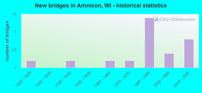
- New bridges - historical statistics
- 11920-1929
- 11940-1949
- 11960-1969
- 11970-1979
- 71980-1989
- 21990-1999
- 42000-2009


- Bridge Condition - Deck
- 6.3%Very good
- 68.8%Good
- 6.3%Satisfactory
- 12.5%Fair
- 6.3%Poor

- Bridge Condition - Superstructure
- 25.0%Very good
- 43.8%Good
- 18.8%Satisfactory
- 6.3%Fair
- 6.3%Poor

- Bridge Condition - Substructure
- 75.0%Good
- 12.5%Satisfactory
- 6.3%Fair
- 6.3%Poor

- Bridge Condition - Channel
- 66.7%Very good
- 20.0%Good
- 13.3%Satisfactory
Find on map >> Show street view
Structure Number: B160018, Location: 0.1M W JCT CTH U (Lat: 46.607469, Lng: -91.889317), Route carried "on" structure: City street , Year Built: 1966, Status: Open, Structure Length: 1.88m (6.17ft), Average Daily Traffic: 180 (year 2019), Average Future Daily Traffic: 181 (year 2040), Design Load: H 15, Features Intersected: AMNICON RIVER, Facility Carried by Structure: LRD PARK RD (DEAD
Minimum Vertical Clearance: 30+ m (98+ ft), Kilometerpoint: 0.000, Lanes on structure: 2, Owner: State Agenciy, Approaching Roadway Width: 7.3m (24.0ft), Skew: 2 degrees, Material/Design: Concrete continuous, Design/Construction: Frame, Number Of Spans In Main Unit: 1, Length of Maximum Span: 17.9m (58.7ft), Curb or Sidewalk Widths: Left: 0.0m, Right: 2.0m (6.6ft), Curb-To-Curb Width: 7.3m (24.0ft), Out-to-Out Width: 9.6m (31.5ft)
Condition: Deck: Good, Superstructure: Good, Substructure: Good, Channel: Very good, Operating Rating: 41.0 metric tons, Method Used To Determine Operating Rating: Load Factor (LF), Inventory Rating: 19.4 metric tons, Method Used To Determine Inventory Rating: Load Factor (LF), Structural Evaluation: Somewhat better than minimum adequacy, Deck Geometry: Somewhat better than minimum adequacy, Waterway Adequacy: Equal to present desirable criteria, Approach Roadway Alignment: Equal to present desirable criteria, Designated Inspection Frequency: Every 24 months, Inspection Date: August 2021, Deck Structure Type: Concrete Cast-file-Place, Wearing Surface/Protective System: Wearing Surface: Monolithic Concrete
Find on map >> Show street view
Structure Number: B160031, Location: 4.1M N JCT CTH B (Lat: 46.572806, Lng: -91.882661), Route carried "on" structure: US 53, Year Built: 1980, Status: Open, Structure Length: 2.93m (9.61ft), Average Daily Traffic: 3,500 (year 2019), Truck Traffic: 9%, Average Future Daily Traffic: 9,110 (year 2039), Design Load: HS 20, Features Intersected: MIDDLE RIVER
Minimum Vertical Clearance: 30+ m (98+ ft), Kilometerpoint: 0.000, Lanes on structure: 2, Base Highway Network: Yes, Owner: State Highway Agency, Approaching Roadway Width: 12.2m (40.0ft), Material/Design: Prestressed concrete, Design/Construction: Stringer/Multi-beam, Number Of Spans In Main Unit: 1, Length of Maximum Span: 28.7m (94.2ft), Curb-To-Curb Width: 12.2m (40.0ft), Out-to-Out Width: 13.1m (43.0ft)
Condition: Deck: Good, Superstructure: Good, Substructure: Good, Channel: Very good, Operating Rating: 82.0 metric tons, Method Used To Determine Operating Rating: Load Factor (LF), Inventory Rating: 37.3 metric tons, Method Used To Determine Inventory Rating: Load Factor (LF), Structural Evaluation: Better than present minimum criteria, Deck Geometry: Better than present minimum criteria, Waterway Adequacy: Equal to present desirable criteria, Approach Roadway Alignment: Equal to present desirable criteria, Designated Inspection Frequency: Every 24 months, Inspection Date: October 2020, Deck Structure Type: Concrete Cast-file-Place, Wearing Surface/Protective System: Wearing Surface: Low Slump Concrete
Find on map >> Show street view
Structure Number: B160033, Location: 1.4M S JCT USH 2 (Lat: 46.588931, Lng: -91.896586), Route carried "on" structure: US 53, Year Built: 1980, Status: Open, Structure Length: 3.92m (12.86ft), Average Daily Traffic: 3,500 (year 2019), Truck Traffic: 9%, Average Future Daily Traffic: 4,534 (year 2039), Design Load: HS 20, Features Intersected: AMNICON RIVER
Minimum Vertical Clearance: 30+ m (98+ ft), Kilometerpoint: 0.000, Lanes on structure: 2, Base Highway Network: Yes, Owner: State Highway Agency, Approaching Roadway Width: 12.2m (40.0ft), Skew: 2 degrees, Material/Design: Prestressed concrete, Design/Construction: Stringer/Multi-beam, Number Of Spans In Main Unit: 1, Length of Maximum Span: 37.8m (124.0ft), Curb-To-Curb Width: 12.2m (40.0ft), Out-to-Out Width: 13.1m (43.0ft)
Condition: Deck: Good, Superstructure: Satisfactory, Substructure: Good, Channel: Very good, Operating Rating: 62.1 metric tons, Method Used To Determine Operating Rating: Load Factor (LF), Inventory Rating: 29.2 metric tons, Method Used To Determine Inventory Rating: Load Factor (LF), Structural Evaluation: Equal to present minimum criteria, Deck Geometry: Better than present minimum criteria, Waterway Adequacy: Equal to present desirable criteria, Approach Roadway Alignment: Equal to present desirable criteria, Designated Inspection Frequency: Every 24 months, Inspection Date: October 2020, Deck Structure Type: Concrete Cast-file-Place, Wearing Surface/Protective System: Wearing Surface: Low Slump Concrete
Find on map >> Show street view
Structure Number: B160034, Location: 5.2M N JCT CTH B (Lat: 46.588944, Lng: -91.895947), Route carried "on" structure: US 53, Year Built: 1980, Status: Open, Structure Length: 3.90m (12.80ft), Average Daily Traffic: 3,500 (year 2019), Truck Traffic: 9%, Average Future Daily Traffic: 9,110 (year 2039), Design Load: HS 20, Features Intersected: AMNICON RIVER
Minimum Vertical Clearance: 30+ m (98+ ft), Kilometerpoint: 0.000, Lanes on structure: 2, Base Highway Network: Yes, Owner: State Highway Agency, Approaching Roadway Width: 12.2m (40.0ft), Skew: 2 degrees, Material/Design: Prestressed concrete, Design/Construction: Stringer/Multi-beam, Number Of Spans In Main Unit: 1, Length of Maximum Span: 37.8m (124.0ft), Curb-To-Curb Width: 12.2m (40.0ft), Out-to-Out Width: 13.1m (43.0ft)
Condition: Deck: Good, Superstructure: Good, Substructure: Good, Channel: Very good, Operating Rating: 75.1 metric tons, Method Used To Determine Operating Rating: Load Factor (LF), Inventory Rating: 42.1 metric tons, Method Used To Determine Inventory Rating: Load Factor (LF), Structural Evaluation: Better than present minimum criteria, Deck Geometry: Better than present minimum criteria, Waterway Adequacy: Equal to present desirable criteria, Approach Roadway Alignment: Equal to present desirable criteria, Designated Inspection Frequency: Every 24 months, Inspection Date: October 2020, Deck Structure Type: Concrete Cast-file-Place, Wearing Surface/Protective System: Wearing Surface: Low Slump Concrete
Find on map >> Show street view
Structure Number: B160046, Location: 0.3M W JCT CTH E (Lat: 46.579417, Lng: -91.914417), Route carried "on" structure: City street , Year Built: 1981, Status: Open, Structure Length: 1.94m (6.36ft), Average Daily Traffic: 107 (year 2019), Average Future Daily Traffic: 117 (year 2039), Design Load: H 20, Features Intersected: AMNICON RIVER, Facility Carried by Structure: LRD SAM ANDERSON R
Minimum Vertical Clearance: 30+ m (98+ ft), Kilometerpoint: 0.000, Lanes on structure: 2, Owner: Town or Township Highway Agency, Approaching Roadway Width: 9.1m (29.9ft), Skew: 3 degrees, Material/Design: Prestressed concrete, Design/Construction: Stringer/Multi-beam, Number Of Spans In Main Unit: 1, Length of Maximum Span: 18.6m (61.0ft), Curb-To-Curb Width: 8.5m (27.9ft), Out-to-Out Width: 9.1m (29.9ft)
Condition: Deck: Good, Superstructure: Very good, Substructure: Satisfactory, Channel: Good, Operating Rating: 29.4 metric tons, Method Used To Determine Operating Rating: Load Factor (LF), Inventory Rating: 25.9 metric tons, Method Used To Determine Inventory Rating: Load Factor (LF), Structural Evaluation: Equal to present minimum criteria, Deck Geometry: Equal to present minimum criteria, Waterway Adequacy: Equal to present desirable criteria, Approach Roadway Alignment: Equal to present desirable criteria, Designated Inspection Frequency: Every 24 months, Inspection Date: September 2020, Deck Structure Type: Concrete Cast-file-Place, Wearing Surface/Protective System: Wearing Surface: Monolithic Concrete
Find on map >> Show street view
Structure Number: B160048, Location: 3.3M N JCT CTH V (Lat: 46.604036, Lng: -91.904722), Route carried "on" structure: US 53, Year Built: 1981, Status: Open, Structure Length: 4.97m (16.31ft), Average Daily Traffic: 3,600 (year 2019), Truck Traffic: 9%, Average Future Daily Traffic: 4,575 (year 2039), Design Load: HS 20, Features Intersected: USH 2 EB
Minimum Vertical Clearance: 30+ m (98+ ft), Kilometerpoint: 0.000, Lanes on structure: 2, Lanes under structure: 2, Base Highway Network: Yes, Owner: State Highway Agency, Approaching Roadway Width: 13.4m (44.0ft), Skew: 4 degrees, Material/Design: Prestressed concrete continuous, Design/Construction: Stringer/Multi-beam, Number Of Spans In Main Unit: 3, Length of Maximum Span: 21.6m (70.9ft), Curb-To-Curb Width: 12.2m (40.0ft), Out-to-Out Width: 13.1m (43.0ft)
Condition: Deck: Good, Superstructure: Good, Substructure: Good, Operating Rating: 60.4 metric tons, Method Used To Determine Operating Rating: Load Factor (LF), Inventory Rating: 30.8 metric tons, Method Used To Determine Inventory Rating: Load Factor (LF), Structural Evaluation: Better than present minimum criteria, Deck Geometry: Better than present minimum criteria, Underclear: Equal to present minimum criteria, Approach Roadway Alignment: Equal to present minimum criteria, Designated Inspection Frequency: Every 24 months, Inspection Date: October 2020, Deck Structure Type: Concrete Cast-file-Place, Wearing Surface/Protective System: Wearing Surface: Low Slump Concrete, Deck Protection: Epoxy Coated Reinforcing
Find on map >> Show street view
Structure Number: B160054, Location: 5.8M E JCT STH 13 TO S (Lat: 46.603903, Lng: -91.888892), Route carried "on" structure: US 2, Year Built: 1984, Status: Open, Structure Length: 1.34m (4.40ft), Average Daily Traffic: 6,500 (year 2019), Truck Traffic: 19%, Average Future Daily Traffic: 6,600 (year 2039), Design Load: HS 20, Features Intersected: AMNICON RIVER
Minimum Vertical Clearance: 30+ m (98+ ft), Kilometerpoint: 0.000, Lanes on structure: 4, Base Highway Network: Yes, Owner: State Highway Agency, Approaching Roadway Width: 20.7m (67.9ft), Skew: 20 degrees, Material/Design: Concrete, Design/Construction: Frame, Number Of Spans In Main Unit: 1, Length of Maximum Span: 11.6m (38.1ft), Curb-To-Curb Width: 20.7m (67.9ft), Out-to-Out Width: 38.1m (125.0ft)
Condition: Deck: Satisfactory, Superstructure: Satisfactory, Substructure: Satisfactory, Channel: Very good, Operating Rating: 49.0 metric tons, Method Used To Determine Operating Rating: Load Factor (LF), Inventory Rating: 32.4 metric tons, Method Used To Determine Inventory Rating: Load Factor (LF), Structural Evaluation: Equal to present minimum criteria, Deck Geometry: Superior to present desirable criteria, Waterway Adequacy: Equal to present desirable criteria, Approach Roadway Alignment: Equal to present desirable criteria, Designated Inspection Frequency: Every 24 months, Inspection Date: July 2020, Deck Structure Type: Concrete Cast-file-Place, Wearing Surface/Protective System: Wearing Surface: Bituminous
Find on map >> Show street view
Structure Number: B160071, Location: 1.6M N JCT CTH V (Lat: 46.580111, Lng: -91.908917), Route carried "on" structure: County highway , Year Built: 1992, Status: Open, Structure Length: 2.43m (7.97ft), Average Daily Traffic: 1,085 (year 2019), Average Future Daily Traffic: 1,193 (year 2039), Design Load: HS 20, Features Intersected: AMNICON RIVER, Facility Carried by Structure: CTH E
Minimum Vertical Clearance: 30+ m (98+ ft), Kilometerpoint: 0.000, Lanes on structure: 2, Owner: County Highway Agency, Approaching Roadway Width: 11.0m (36.1ft), Material/Design: Prestressed concrete, Design/Construction: Stringer/Multi-beam, Number Of Spans In Main Unit: 1, Length of Maximum Span: 23.8m (78.1ft), Curb-To-Curb Width: 8.5m (27.9ft), Out-to-Out Width: 9.1m (29.9ft)
Condition: Deck: Good, Superstructure: Very good, Substructure: Good, Channel: Very good, Operating Rating: 68.6 metric tons, Method Used To Determine Operating Rating: Load Factor (LF), Inventory Rating: 35.6 metric tons, Method Used To Determine Inventory Rating: Load Factor (LF), Structural Evaluation: Better than present minimum criteria, Deck Geometry: Somewhat better than minimum adequacy, Waterway Adequacy: Superior to present desirable criteria, Approach Roadway Alignment: Equal to present desirable criteria, Designated Inspection Frequency: Every 48 months, Inspection Date: September 2020, Deck Structure Type: Concrete Cast-file-Place, Wearing Surface/Protective System: Wearing Surface: Monolithic Concrete, Deck Protection: Epoxy Coated Reinforcing
Find on map >> Show street view
Structure Number: B160091, Location: 0.8M W JCT USH 2 (Lat: 46.589917, Lng: -91.833000), Route carried "on" structure: City street , Year Built: 1998, Status: Open, Structure Length: 1.37m (4.49ft), Average Daily Traffic: 54 (year 2019), Average Future Daily Traffic: 59 (year 2039), Design Load: HS 20, Features Intersected: MIDDLE RIVER, Facility Carried by Structure: LRD BAYFIELD RD
Minimum Vertical Clearance: 30+ m (98+ ft), Kilometerpoint: 0.000, Lanes on structure: 2, Owner: Town or Township Highway Agency, Approaching Roadway Width: 6.7m (22.0ft), Skew: 3 degrees, Material/Design: Concrete, Design/Construction: Slab, Number Of Spans In Main Unit: 1, Length of Maximum Span: 13.0m (42.7ft), Curb-To-Curb Width: 7.2m (23.6ft), Out-to-Out Width: 7.8m (25.6ft)
Condition: Deck: Good, Superstructure: Good, Substructure: Good, Channel: Very good, Operating Rating: 67.0 metric tons, Method Used To Determine Operating Rating: Load Factor (LF), Inventory Rating: 38.9 metric tons, Method Used To Determine Inventory Rating: Load Factor (LF), Structural Evaluation: Better than present minimum criteria, Deck Geometry: Somewhat better than minimum adequacy, Waterway Adequacy: Equal to present desirable criteria, Approach Roadway Alignment: High priority of corrective action, Length Of Structure Improvement: 1.80m (5.91ft), Designated Inspection Frequency: Every 48 months, Inspection Date: September 2020, Bridge Improvement Cost: $140,000, Roadway Improvement Cost: $14,000, Total Project Cost: $210,000 ( Estimate for 2021), Deck Structure Type: Concrete Cast-file-Place, Wearing Surface/Protective System: Wearing Surface: Monolithic Concrete, Deck Protection: Epoxy Coated Reinforcing
Find on map >> Show street view
Structure Number: B16011, Location: 7.0M W JCT USH 53 (Lat: 46.359889, Lng: -91.963056), Route carried "on" structure: County highway , Year Built: 2003, Status: Open, Structure Length: 1.91m (6.27ft), Average Daily Traffic: 227 (year 2019), Average Future Daily Traffic: 249 (year 2039), Design Load: HS 20, Features Intersected: MOOSE RIVER, Facility Carried by Structure: CTH A
Minimum Vertical Clearance: 30+ m (98+ ft), Kilometerpoint: 0.000, Lanes on structure: 2, Owner: County Highway Agency, Approaching Roadway Width: 9.8m (32.2ft), Skew: 3 degrees, Material/Design: Concrete, Design/Construction: Slab, Number Of Spans In Main Unit: 2, Length of Maximum Span: 9.1m (29.9ft), Curb-To-Curb Width: 9.1m (29.9ft), Out-to-Out Width: 9.8m (32.2ft)
Condition: Deck: Good, Superstructure: Good, Substructure: Good, Channel: Very good, Operating Rating: 62.1 metric tons, Method Used To Determine Operating Rating: Load Factor (LF), Inventory Rating: 37.3 metric tons, Method Used To Determine Inventory Rating: Load Factor (LF), Structural Evaluation: Better than present minimum criteria, Deck Geometry: Equal to present minimum criteria, Waterway Adequacy: Equal to present desirable criteria, Approach Roadway Alignment: Equal to present desirable criteria, Designated Inspection Frequency: Every 24 months, Inspection Date: September 2020, Wearing Surface/Protective System: Wearing Surface: Monolithic Concrete, Deck Protection: Epoxy Coated Reinforcing
Find on map >> Show street view
Structure Number: B160118, Location: 0.3M W JCT CTH D (Lat: 46.619139, Lng: -91.809750), Route carried "on" structure: City street , Year Built: 2005, Status: Open, Structure Length: 2.21m (7.25ft), Average Daily Traffic: 73 (year 2019), Truck Traffic: 5%, Average Future Daily Traffic: 80 (year 2039), Design Load: HS 20, Features Intersected: MIDDLE RIVER, Facility Carried by Structure: LRD MOONSHINE RD
Minimum Vertical Clearance: 30+ m (98+ ft), Kilometerpoint: 0.000, Lanes on structure: 2, Owner: Town or Township Highway Agency, Approaching Roadway Width: 7.3m (24.0ft), Skew: 1 degrees, Material/Design: Prestressed concrete, Design/Construction: Stringer/Multi-beam, Number Of Spans In Main Unit: 1, Length of Maximum Span: 21.3m (69.9ft), Curb-To-Curb Width: 7.3m (24.0ft), Out-to-Out Width: 7.9m (25.9ft)
Condition: Deck: Good, Superstructure: Very good, Substructure: Good, Channel: Good, Operating Rating: 52.3 metric tons, Method Used To Determine Operating Rating: Load Factor (LF), Inventory Rating: 40.5 metric tons, Method Used To Determine Inventory Rating: Load Factor (LF), Structural Evaluation: Better than present minimum criteria, Deck Geometry: Equal to present minimum criteria, Waterway Adequacy: Equal to present desirable criteria, Approach Roadway Alignment: Equal to present minimum criteria, Designated Inspection Frequency: Every 48 months, Inspection Date: September 2020, Deck Structure Type: Concrete Cast-file-Place, Wearing Surface/Protective System: Wearing Surface: Monolithic Concrete, Deck Protection: Epoxy Coated Reinforcing
Find on map >> Show street view
Structure Number: B160123, Location: 1.6M S JCT USH 2 (Lat: 46.580611, Lng: -91.846528), Route carried "on" structure: City street , Year Built: 2006, Status: Open, Structure Length: 0.91m (2.99ft), Average Daily Traffic: 105 (year 2019), Truck Traffic: 5%, Average Future Daily Traffic: 115 (year 2039), Design Load: HS 20, Features Intersected: MIDDLE RIVER, Facility Carried by Structure: LRD LACKSON RD
Minimum Vertical Clearance: 30+ m (98+ ft), Kilometerpoint: 0.000, Lanes on structure: 2, Owner: Town or Township Highway Agency, Approaching Roadway Width: 7.3m (24.0ft), Material/Design: Concrete, Design/Construction: Slab, Number Of Spans In Main Unit: 1, Length of Maximum Span: 8.5m (27.9ft), Curb-To-Curb Width: 7.3m (24.0ft), Out-to-Out Width: 7.9m (25.9ft)
Condition: Deck: Good, Superstructure: Good, Substructure: Good, Channel: Good, Operating Rating: 65.0 metric tons, Method Used To Determine Operating Rating: Load Factor (LF), Inventory Rating: 38.9 metric tons, Method Used To Determine Inventory Rating: Load Factor (LF), Structural Evaluation: Better than present minimum criteria, Deck Geometry: Somewhat better than minimum adequacy, Waterway Adequacy: Equal to present desirable criteria, Approach Roadway Alignment: Equal to present desirable criteria, Designated Inspection Frequency: Every 48 months, Inspection Date: September 2020, Deck Structure Type: Concrete Cast-file-Place, Wearing Surface/Protective System: Wearing Surface: Monolithic Concrete, Deck Protection: Epoxy Coated Reinforcing
Find on map >> Show street view
Structure Number: B160124, Location: 1.8M S JCT USH 2 (Lat: 46.579194, Lng: -91.846528), Route carried "on" structure: City street , Year Built: 2006, Status: Open, Structure Length: 0.77m (2.53ft), Average Daily Traffic: 105 (year 2019), Truck Traffic: 5%, Average Future Daily Traffic: 115 (year 2039), Design Load: HS 20, Features Intersected: BR MIDDLE RIVER, Facility Carried by Structure: LRD LACKSON RD
Minimum Vertical Clearance: 30+ m (98+ ft), Kilometerpoint: 0.000, Lanes on structure: 2, Owner: Town or Township Highway Agency, Approaching Roadway Width: 7.3m (24.0ft), Skew: 2 degrees, Material/Design: Concrete, Design/Construction: Slab, Number Of Spans In Main Unit: 1, Length of Maximum Span: 7.0m (23.0ft), Curb-To-Curb Width: 7.3m (24.0ft), Out-to-Out Width: 7.9m (25.9ft)
Condition: Deck: Very good, Superstructure: Very good, Substructure: Good, Channel: Very good, Operating Rating: 71.8 metric tons, Method Used To Determine Operating Rating: Load Factor (LF), Inventory Rating: 42.1 metric tons, Method Used To Determine Inventory Rating: Load Factor (LF), Structural Evaluation: Better than present minimum criteria, Deck Geometry: Somewhat better than minimum adequacy, Waterway Adequacy: Equal to present desirable criteria, Approach Roadway Alignment: Equal to present desirable criteria, Designated Inspection Frequency: Every 48 months, Inspection Date: September 2020, Deck Structure Type: Concrete Cast-file-Place, Wearing Surface/Protective System: Wearing Surface: Monolithic Concrete, Deck Protection: Epoxy Coated Reinforcing
Find on map >> Show street view
Structure Number: P160064, Location: 0.6M E JCT CTH UU (Lat: 46.630750, Lng: -91.909139), Route carried "on" structure: County highway , Year Built: 1973, Status: Open, Structure Length: 2.33m (7.64ft), Average Daily Traffic: 151 (year 2019), Average Future Daily Traffic: 166 (year 2040), Design Load: HS 20, Features Intersected: AMNICON RIVER, Facility Carried by Structure: CTH U
Minimum Vertical Clearance: 30+ m (98+ ft), Kilometerpoint: 0.000, Lanes on structure: 2, Owner: County Highway Agency, Approaching Roadway Width: 8.5m (27.9ft), Material/Design: Steel, Design/Construction: Stringer/Multi-beam, Number Of Spans In Main Unit: 1, Length of Maximum Span: 22.3m (73.2ft), Curb-To-Curb Width: 8.7m (28.5ft), Out-to-Out Width: 9.7m (31.8ft)
Condition: Deck: Fair, Superstructure: Fair, Substructure: Good, Channel: Very good, Operating Rating: 62.1 metric tons, Method Used To Determine Operating Rating: Load Factor (LF), Inventory Rating: 35.6 metric tons, Method Used To Determine Inventory Rating: Load Factor (LF), Structural Evaluation: Somewhat better than minimum adequacy, Deck Geometry: Equal to present minimum criteria, Waterway Adequacy: Superior to present desirable criteria, Approach Roadway Alignment: Equal to present desirable criteria, Designated Inspection Frequency: Every 24 months, Inspection Date: September 2021, Deck Structure Type: Concrete Cast-file-Place, Wearing Surface/Protective System: Wearing Surface: Bituminous
Find on map >> Show street view
Structure Number: P160092, Location: 0.3 M W JCT USH 53 (Lat: 46.561167, Lng: -91.878083), Route carried "on" structure: City street , Year Built: 1940, Status: Open, Structure Length: 0.82m (2.69ft), Average Daily Traffic: 107 (year 2019), Average Future Daily Traffic: 117 (year 2039), Design Load: HS 20, Features Intersected: MIDDLE RIVER, Facility Carried by Structure: LRD MIDDLE RIVER R
Minimum Vertical Clearance: 30+ m (98+ ft), Kilometerpoint: 0.000, Lanes on structure: 2, Owner: Town or Township Highway Agency, Approaching Roadway Width: 7.9m (25.9ft), Material/Design: Steel, Design/Construction: Stringer/Multi-beam, Number Of Spans In Main Unit: 1, Length of Maximum Span: 7.6m (24.9ft), Curb-To-Curb Width: 5.8m (19.0ft), Out-to-Out Width: 6.2m (20.3ft)
Condition: Deck: Fair, Superstructure: Satisfactory, Substructure: Fair, Channel: Satisfactory, Operating Rating: 62.1 metric tons, Method Used To Determine Operating Rating: Load Factor (LF), Inventory Rating: 37.3 metric tons, Method Used To Determine Inventory Rating: Load Factor (LF), Structural Evaluation: Somewhat better than minimum adequacy, Deck Geometry: High priority of corrective action, Waterway Adequacy: Equal to present minimum criteria, Approach Roadway Alignment: Equal to present minimum criteria, Length Of Structure Improvement: 1.25m (4.10ft), Designated Inspection Frequency: Every 24 months, Inspection Date: September 2020, Bridge Improvement Cost: $97,000, Roadway Improvement Cost: $9,000, Total Project Cost: $146,000 ( Estimate for 2021), Deck Structure Type: Concrete Cast-file-Place, Wearing Surface/Protective System: Wearing Surface: Monolithic Concrete
Find on map >> Show street view
Structure Number: P160095, Location: 0.6M S JCT USH 53 (Lat: 46.549000, Lng: -91.888611), Route carried "on" structure: City street , Year Built: 1925, Status: Open, Structure Length: 1.13m (3.71ft), Average Daily Traffic: 86 (year 2019), Average Future Daily Traffic: 94 (year 2040), Design Load: H 15, Features Intersected: MIDDLE RIVER, Facility Carried by Structure: LRD OLD ROAD 11
Minimum Vertical Clearance: 30+ m (98+ ft), Kilometerpoint: 0.000, Lanes on structure: 1, Owner: Town or Township Highway Agency, Approaching Roadway Width: 6.1m (20.0ft), Material/Design: Concrete, Design/Construction: Arch - Deck, Number Of Spans In Main Unit: 1, Length of Maximum Span: 10.1m (33.1ft), Curb-To-Curb Width: 4.7m (15.4ft), Out-to-Out Width: 5.4m (17.7ft)
Condition: Deck: Poor, Superstructure: Poor, Substructure: Poor, Channel: Satisfactory, Operating Rating: 33.0 metric tons, Method Used To Determine Operating Rating: Load Factor (LF), Inventory Rating: 19.4 metric tons, Method Used To Determine Inventory Rating: Load Factor (LF), Structural Evaluation: Meets minimum limits, Deck Geometry: Better than present minimum criteria, Waterway Adequacy: Equal to present desirable criteria, Approach Roadway Alignment: High priority of corrective action, Length Of Structure Improvement: 1.58m (5.18ft), Designated Inspection Frequency: Every 12 months, Inspection Date: September 2021, Bridge Improvement Cost: $121,000, Roadway Improvement Cost: $12,000, Total Project Cost: $182,000 ( Estimate for 2021), Deck Structure Type: Concrete Cast-file-Place, Wearing Surface/Protective System: Wearing Surface: Monolithic Concrete
Find on map >> Show street view
Structure Number: B160048, Location: 5.0M E JCT STH 13 (A) (Lat: 46.604036, Lng: -91.904722), Route carried "under" structure: US 2, Year Built: 1981, Structure Length: 0. m, Average Daily Traffic: 3,250 (year 2019), Truck Traffic: 8%, Features Intersected: USH 2 EB, Facility Carried by Structure: USH 53 NB
Minimum Vertical Clearance: 5.18m (16.99ft), Kilometerpoint: 0.000, Lanes on structure: 2, Lanes under structure: 2, Material/Design: Prestressed concrete continuous, Design/Construction: Stringer/Multi-beam, Length of Maximum Span: 21.6m (70.9ft)