Bridge Statistics for Amherstdale-Robinette, West Virginia (WV)
Condition, Traffic, Stress, Structural Evaluation, Project Costs
- National Bridge Inventory (NBI) Statistics
- 15Number of bridges
- 95ft / 28.7mTotal length
- $786,000Total costs
- 33,119Total average daily traffic
- 1,977Total average daily truck traffic
- National Bridge Inventory (NBI) Registered Bridges for Amherstdale-Robinette
- No street view available for this location
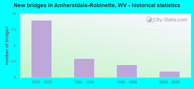
- New bridges - historical statistics
- 91970-1979
- 31980-1989
- 21990-1999
- 12000-2009


- Bridge Condition - Deck
- 20.0%Good
- 40.0%Satisfactory
- 30.0%Fair
- 10.0%Poor

- Bridge Condition - Superstructure
- 20.0%Good
- 20.0%Satisfactory
- 30.0%Fair
- 30.0%Poor

- Bridge Condition - Substructure
- 30.0%Satisfactory
- 50.0%Fair
- 20.0%Poor

- Bridge Condition - Channel
- 53.8%Good
- 23.1%Satisfactory
- 23.1%Fair
Find on map >> Show street view
Structure Number: 23A077, Location: 0.15 MILE EAST OF CR 16 (Lat: 37.767450, Lng: -81.833939), Route carried "on" structure: County highway 1601, Year Built: 1988, Status: Open, Structure Length: 1.39m (4.56ft), Average Daily Traffic: 1,200 (year 2018), Truck Traffic: 6%, Average Future Daily Traffic: 1,584 (year 2038), Design Load: HS 20, Features Intersected: RT FK OF BUFFALO CREEK, Facility Carried by Structure: CR 16/1
Minimum Vertical Clearance: 30+ m (98+ ft), Kilometerpoint: 0.241, Lanes on structure: 2, Owner: State Highway Agency, Approaching Roadway Width: 7.6m (24.9ft), Skew: 4 degrees, Material/Design: Prestressed concrete, Design/Construction: Box Beam or Girders - Multiple, Number Of Spans In Main Unit: 1, Length of Maximum Span: 13.4m (44.0ft), Curb-To-Curb Width: 7.0m (23.0ft), Out-to-Out Width: 7.4m (24.3ft)
Condition: Deck: Good, Superstructure: Good, Substructure: Poor, Channel: Fair, Operating Rating: 88.9 metric tons, Method Used To Determine Operating Rating: Load Factor (LF), Inventory Rating: 54.4 metric tons, Method Used To Determine Inventory Rating: Load Factor (LF), Structural Evaluation: Meets minimum limits, Deck Geometry: High priority of corrective action, Waterway Adequacy: Better than present minimum criteria, Approach Roadway Alignment: Better than present minimum criteria, Length Of Structure Improvement: 1.68m (5.51ft), Designated Inspection Frequency: Every 24 months, Inspection Date: Febuary 2020, Bridge Improvement Cost: $15,000, Roadway Improvement Cost: $5,000, Total Project Cost: $20,000 ( Estimate for 2016), Deck Structure Type: Other, Wearing Surface/Protective System: Wearing Surface: Bituminous
Find on map >> Show street view
Structure Number: 23A078, Location: 0.87 MI EAST OF CR 16 (Lat: 37.762069, Lng: -81.823339), Route carried "on" structure: County highway 1601, Year Built: 1988, Status: Open, Structure Length: 1.39m (4.56ft), Average Daily Traffic: 1,200 (year 2018), Truck Traffic: 6%, Average Future Daily Traffic: 1,584 (year 2038), Design Load: HS 20, Features Intersected: RT FK OF BUFFALO CREEK, Facility Carried by Structure: CR 16/1
Minimum Vertical Clearance: 30+ m (98+ ft), Kilometerpoint: 1.400, Lanes on structure: 2, Owner: State Highway Agency, Approaching Roadway Width: 7.0m (23.0ft), Skew: 4 degrees, Material/Design: Prestressed concrete, Design/Construction: Box Beam or Girders - Multiple, Number Of Spans In Main Unit: 1, Length of Maximum Span: 13.4m (44.0ft), Curb-To-Curb Width: 7.0m (23.0ft), Out-to-Out Width: 7.4m (24.3ft)
Condition: Deck: Good, Superstructure: Good, Substructure: Fair, Channel: Fair, Operating Rating: 88.9 metric tons, Method Used To Determine Operating Rating: Load Factor (LF), Inventory Rating: 57.1 metric tons, Method Used To Determine Inventory Rating: Load Factor (LF), Structural Evaluation: Somewhat better than minimum adequacy, Deck Geometry: High priority of corrective action, Waterway Adequacy: Equal to present minimum criteria, Approach Roadway Alignment: Equal to present minimum criteria, Length Of Structure Improvement: 1.40m (4.59ft), Designated Inspection Frequency: Every 24 months, Inspection Date: Febuary 2020, Bridge Improvement Cost: $25,000, Roadway Improvement Cost: $1,000, Total Project Cost: $30,000 ( Estimate for 2016), Deck Structure Type: Other, Wearing Surface/Protective System: Wearing Surface: Bituminous
Find on map >> Show street view
Structure Number: 23A081, Location: 0.01 MI. W. OF CR. 16 (Lat: 37.785150, Lng: -81.797150), Route carried "on" structure: County highway 1606, Year Built: 1976, Status: Open, Structure Length: 2.79m (9.15ft), Average Daily Traffic: 450 (year 2019), Truck Traffic: 6%, Average Future Daily Traffic: 500 (year 2039), Features Intersected: BUFFALO CREEK, Facility Carried by Structure: CR 16/6
Minimum Vertical Clearance: 30+ m (98+ ft), Kilometerpoint: 1.062, Lanes on structure: 2, Owner: State Highway Agency, Approaching Roadway Width: 8.8m (28.9ft), Material/Design: Prestressed concrete, Design/Construction: Channel Beam, Number Of Spans In Main Unit: 2, Length of Maximum Span: 13.6m (44.6ft), Curb or Sidewalk Widths: Left: 0.2m (0.7ft), Right: 0.2m (0.7ft), Curb-To-Curb Width: 8.7m (28.5ft), Out-to-Out Width: 9.2m (30.2ft)
Condition: Deck: Poor, Superstructure: Poor, Substructure: Satisfactory, Channel: Good, Operating Rating: 52.6 metric tons, Method Used To Determine Operating Rating: Field evaluation and documented engineering judgment, Inventory Rating: 21.8 metric tons, Method Used To Determine Inventory Rating: Field evaluation and documented engineering judgment, Structural Evaluation: Meets minimum limits, Deck Geometry: Somewhat better than minimum adequacy, Waterway Adequacy: Equal to present minimum criteria, Approach Roadway Alignment: Better than present minimum criteria, Designated Inspection Frequency: Every 24 months, Inspection Date: April 2021, Deck Structure Type: Other, Wearing Surface/Protective System: Wearing Surface: Bituminous
Find on map >> Show street view
Structure Number: 23A092, Location: 0.41 MILE EAST OF CR 16/1 (Lat: 37.772011, Lng: -81.830900), Route carried "on" structure: County highway 1600, Year Built: 1976, Status: Open, Structure Length: 3.68m (12.07ft), Average Daily Traffic: 6,300 (year 2018), Truck Traffic: 6%, Average Future Daily Traffic: 8,316 (year 2038), Design Load: HS 20, Features Intersected: BUFFALO CREEK, Facility Carried by Structure: CR 16
Minimum Vertical Clearance: 30+ m (98+ ft), Kilometerpoint: 5.552, Lanes on structure: 2, Owner: State Highway Agency, Approaching Roadway Width: 13.4m (44.0ft), Skew: 3 degrees, Material/Design: Steel, Design/Construction: Stringer/Multi-beam, Number Of Spans In Main Unit: 1, Length of Maximum Span: 35.1m (115.2ft), Curb-To-Curb Width: 14.2m (46.6ft), Out-to-Out Width: 15.4m (50.5ft)
Condition: Deck: Satisfactory, Superstructure: Fair, Substructure: Satisfactory, Channel: Good, Operating Rating: 88.9 metric tons, Method Used To Determine Operating Rating: Load Factor (LF), Inventory Rating: 59.9 metric tons, Method Used To Determine Inventory Rating: Load Factor (LF), Structural Evaluation: Somewhat better than minimum adequacy, Deck Geometry: Superior to present desirable criteria, Waterway Adequacy: Equal to present minimum criteria, Approach Roadway Alignment: Better than present minimum criteria, Designated Inspection Frequency: Every 24 months, Inspection Date: July 2020, Deck Structure Type: Concrete Cast-file-Place, Wearing Surface/Protective System: Wearing Surface: Monolithic Concrete, Deck Protection: Epoxy Coated Reinforcing
Find on map >> Show street view
Structure Number: 23A093, Location: 0.79 MI WEST OF CR 16/42 (Lat: 37.774969, Lng: -81.823239), Route carried "on" structure: County highway 1600, Year Built: 1976, Status: Open, Structure Length: 4.62m (15.16ft), Average Daily Traffic: 6,300 (year 2018), Truck Traffic: 6%, Average Future Daily Traffic: 8,316 (year 2038), Design Load: HS 20, Features Intersected: BUFFALO CREEK, Facility Carried by Structure: CR 16
Minimum Vertical Clearance: 30+ m (98+ ft), Kilometerpoint: 6.309, Lanes on structure: 2, Owner: State Highway Agency, Approaching Roadway Width: 15.2m (49.9ft), Skew: 4 degrees, Material/Design: Steel continuous, Design/Construction: Stringer/Multi-beam, Number Of Spans In Main Unit: 1, Number Of Approach Spans: 2, Length of Maximum Span: 18.6m (61.0ft), Curb-To-Curb Width: 14.2m (46.6ft), Out-to-Out Width: 14.7m (48.2ft)
Condition: Deck: Satisfactory, Superstructure: Fair, Substructure: Satisfactory, Channel: Satisfactory, Operating Rating: 66.2 metric tons, Method Used To Determine Operating Rating: Load Factor (LF), Inventory Rating: 39.9 metric tons, Method Used To Determine Inventory Rating: Load Factor (LF), Structural Evaluation: Somewhat better than minimum adequacy, Deck Geometry: Superior to present desirable criteria, Waterway Adequacy: Equal to present minimum criteria, Approach Roadway Alignment: Better than present minimum criteria, Length Of Structure Improvement: 4.63m (15.19ft), Designated Inspection Frequency: Every 24 months, Inspection Date: June 2020, Bridge Improvement Cost: $280,000, Roadway Improvement Cost: $10,000, Total Project Cost: $346,000 ( Estimate for 2018), Deck Structure Type: Concrete Cast-file-Place, Wearing Surface/Protective System: Wearing Surface: Monolithic Concrete, Deck Protection: Epoxy Coated Reinforcing
Find on map >> Show street view
Structure Number: 23A094, Location: 0.05 MI WEST OF CR 16/23 (Lat: 37.785500, Lng: -81.809189), Route carried "on" structure: County highway 1600, Year Built: 1976, Status: Open, Structure Length: 3.68m (12.07ft), Average Daily Traffic: 4,239 (year 2019), Truck Traffic: 6%, Average Future Daily Traffic: 5,595 (year 2039), Design Load: HS 20, Features Intersected: BUFFALO CREEK, Facility Carried by Structure: CR 16
Minimum Vertical Clearance: 30+ m (98+ ft), Kilometerpoint: 8.224, Lanes on structure: 2, Owner: State Highway Agency, Approaching Roadway Width: 13.4m (44.0ft), Skew: 3 degrees, Material/Design: Steel, Design/Construction: Stringer/Multi-beam, Number Of Spans In Main Unit: 1, Length of Maximum Span: 35.1m (115.2ft), Curb-To-Curb Width: 14.2m (46.6ft), Out-to-Out Width: 15.4m (50.5ft)
Condition: Deck: Satisfactory, Superstructure: Poor, Substructure: Poor, Channel: Fair, Operating Rating: 88.9 metric tons, Method Used To Determine Operating Rating: Load Factor (LF), Inventory Rating: 59.9 metric tons, Method Used To Determine Inventory Rating: Load Factor (LF), Structural Evaluation: Meets minimum limits, Deck Geometry: Superior to present desirable criteria, Waterway Adequacy: Equal to present minimum criteria, Approach Roadway Alignment: Equal to present desirable criteria, Designated Inspection Frequency: Every 24 months, Other Special Inspection Frequency: Every 12 months, Inspection Date: April 2021, Other Special Inspection Date: April 2021, Deck Structure Type: Concrete Cast-file-Place, Wearing Surface/Protective System: Wearing Surface: Monolithic Concrete, Deck Protection: Epoxy Coated Reinforcing
Find on map >> Show street view
Structure Number: 23A096, Location: 0.01 MI WEST OF CR 16/4 (Lat: 37.796869, Lng: -81.732450), Route carried "on" structure: County highway 1600, Year Built: 1974, Status: Open, Structure Length: 0.67m (2.20ft), Average Daily Traffic: 2,000 (year 2018), Truck Traffic: 6%, Average Future Daily Traffic: 2,640 (year 2038), Features Intersected: DINGESS BRANCH, Facility Carried by Structure: CR 16
Minimum Vertical Clearance: 30+ m (98+ ft), Kilometerpoint: 16.946, Lanes on structure: 2, Owner: State Highway Agency, Approaching Roadway Width: 14.0m (45.9ft), Material/Design: Concrete, Design/Construction: Culvert, Number Of Spans In Main Unit: 1, Length of Maximum Span: 6.1m (20.0ft)
Condition: Channel: Good, Culverts: Satisfactory, Operating Rating: 71.7 metric tons, Method Used To Determine Operating Rating: Field evaluation and documented engineering judgment, Inventory Rating: 32.7 metric tons, Method Used To Determine Inventory Rating: Field evaluation and documented engineering judgment, Structural Evaluation: Equal to present minimum criteria, Waterway Adequacy: Equal to present minimum criteria, Approach Roadway Alignment: Better than present minimum criteria, Designated Inspection Frequency: Every 24 months, Inspection Date: April 2020
Find on map >> Show street view
Structure Number: 23A181, Location: 0.01 MI NORTH OF CR 16 (Lat: 37.790389, Lng: -81.782811), Route carried "on" structure: County highway 1614, Year Built: 1991, Status: Open, Structure Length: 1.81m (5.94ft), Average Daily Traffic: 20 (year 2019), Truck Traffic: 6%, Average Future Daily Traffic: 26 (year 2039), Design Load: HS 25 or greater, Features Intersected: BUFFALO CREEK, Facility Carried by Structure: CR 16/14
Minimum Vertical Clearance: 30+ m (98+ ft), Kilometerpoint: 0.016, Lanes on structure: 2, Owner: State Highway Agency, Approaching Roadway Width: 8.2m (26.9ft), Material/Design: Prestressed concrete, Design/Construction: Box Beam or Girders - Multiple, Number Of Spans In Main Unit: 1, Length of Maximum Span: 17.7m (58.1ft), Curb-To-Curb Width: 8.0m (26.2ft), Out-to-Out Width: 8.2m (26.9ft)
Condition: Deck: Fair, Superstructure: Fair, Substructure: Fair, Channel: Good, Operating Rating: 88.9 metric tons, Method Used To Determine Operating Rating: Load Factor (LF), Inventory Rating: 67.1 metric tons, Method Used To Determine Inventory Rating: Load Factor (LF), Structural Evaluation: Somewhat better than minimum adequacy, Deck Geometry: Equal to present minimum criteria, Waterway Adequacy: Better than present minimum criteria, Approach Roadway Alignment: Better than present minimum criteria, Designated Inspection Frequency: Every 24 months, Inspection Date: January 2021, Deck Structure Type: Other, Wearing Surface/Protective System: Wearing Surface: Monolithic Concrete
Find on map >> Show street view
Structure Number: 23A21, Location: 0.10 MI EAST OF CR 16 (Lat: 37.789981, Lng: -81.757561), Route carried "on" structure: County highway 1624, Year Built: 1975, Status: Open, Structure Length: 3.78m (12.40ft), Average Daily Traffic: 50 (year 2019), Truck Traffic: 6%, Average Future Daily Traffic: 66 (year 2039), Features Intersected: BUFFALO CREEK, Facility Carried by Structure: CR 16/24
Minimum Vertical Clearance: 30+ m (98+ ft), Kilometerpoint: 0.161, Lanes on structure: 2, Owner: State Highway Agency, Approaching Roadway Width: 8.5m (27.9ft), Skew: 6 degrees, Material/Design: Steel, Design/Construction: Stringer/Multi-beam, Number Of Spans In Main Unit: 2, Length of Maximum Span: 18.1m (59.4ft), Curb or Sidewalk Widths: Left: 0.2m (0.7ft), Right: 0.2m (0.7ft), Curb-To-Curb Width: 8.2m (26.9ft), Out-to-Out Width: 8.6m (28.2ft)
Condition: Deck: Fair, Superstructure: Satisfactory, Substructure: Fair, Channel: Good, Operating Rating: 47.2 metric tons, Method Used To Determine Operating Rating: Load Factor (LF), Inventory Rating: 28.1 metric tons, Method Used To Determine Inventory Rating: Load Factor (LF), Structural Evaluation: Somewhat better than minimum adequacy, Deck Geometry: Equal to present minimum criteria, Waterway Adequacy: Equal to present minimum criteria, Approach Roadway Alignment: Better than present minimum criteria, Designated Inspection Frequency: Every 24 months, Inspection Date: October 2020, Deck Structure Type: Closed Grating, Wearing Surface/Protective System: Wearing Surface: Bituminous
Find on map >> Show street view
Structure Number: 23A239, Location: 0.03 MI EAST OF CR 16/23 (Lat: 37.785111, Lng: -81.793550), Route carried "on" structure: County highway 1600, Year Built: 1974, Status: Open, Structure Length: 0.63m (2.07ft), Average Daily Traffic: 2,000 (year 2018), Truck Traffic: 6%, Average Future Daily Traffic: 2,640 (year 2038), Design Load: HS 20, Features Intersected: ROBINETTE BRANCH, Facility Carried by Structure: CR 16
Minimum Vertical Clearance: 30+ m (98+ ft), Kilometerpoint: 9.720, Lanes on structure: 2, Owner: State Highway Agency, Approaching Roadway Width: 14.3m (46.9ft), Skew: 1 degrees, Material/Design: Concrete, Design/Construction: Culvert, Number Of Spans In Main Unit: 1, Length of Maximum Span: 6.3m (20.7ft)
Condition: Channel: Satisfactory, Culverts: Satisfactory, Operating Rating: 71.7 metric tons, Method Used To Determine Operating Rating: Field evaluation and documented engineering judgment, Inventory Rating: 32.7 metric tons, Method Used To Determine Inventory Rating: Field evaluation and documented engineering judgment, Structural Evaluation: Equal to present minimum criteria, Waterway Adequacy: Equal to present minimum criteria, Approach Roadway Alignment: Better than present minimum criteria, Designated Inspection Frequency: Every 24 months, Inspection Date: June 2020
Find on map >> Show street view
Structure Number: 23A24, Location: 0.02 MI WEST OF CR 16/58 (Lat: 37.795489, Lng: -81.763019), Route carried "on" structure: County highway 1600, Year Built: 1974, Status: Open, Structure Length: 0.61m (2.00ft), Average Daily Traffic: 2,000 (year 2018), Truck Traffic: 6%, Average Future Daily Traffic: 2,340 (year 2038), Design Load: HS 20, Features Intersected: CARTWRIGHT BRANCH, Facility Carried by Structure: CR 16
Minimum Vertical Clearance: 30+ m (98+ ft), Kilometerpoint: 12.939, Lanes on structure: 2, Owner: State Highway Agency, Approaching Roadway Width: 14.6m (47.9ft), Material/Design: Concrete, Design/Construction: Culvert, Number Of Spans In Main Unit: 1, Length of Maximum Span: 6.1m (20.0ft)
Condition: Channel: Satisfactory, Culverts: Satisfactory, Operating Rating: 71.7 metric tons, Method Used To Determine Operating Rating: Field evaluation and documented engineering judgment, Inventory Rating: 32.7 metric tons, Method Used To Determine Inventory Rating: Field evaluation and documented engineering judgment, Structural Evaluation: Equal to present minimum criteria, Waterway Adequacy: Equal to present minimum criteria, Approach Roadway Alignment: Better than present minimum criteria, Designated Inspection Frequency: Every 24 months, Inspection Date: June 2020
Find on map >> Show street view
Structure Number: 23A263, Location: 0.01 MILE NORTH OF CR 16 (Lat: 37.786539, Lng: -81.806931), Route carried "on" structure: County highway 1606, Year Built: 1997, Status: Open, Structure Length: 1.83m (6.00ft), Average Daily Traffic: 400 (year 2020), Truck Traffic: 7%, Average Future Daily Traffic: 420 (year 2040), Design Load: HS 25 or greater, Features Intersected: BUFFALO CREEK, Facility Carried by Structure: CR 16/6
Minimum Vertical Clearance: 30+ m (98+ ft), Kilometerpoint: 0.016, Lanes on structure: 1, Owner: State Highway Agency, Approaching Roadway Width: 4.3m (14.1ft), Skew: 1 degrees, Material/Design: Prestressed concrete, Design/Construction: Box Beam or Girders - Multiple, Number Of Spans In Main Unit: 1, Length of Maximum Span: 18.0m (59.1ft), Curb-To-Curb Width: 4.3m (14.1ft), Out-to-Out Width: 4.6m (15.1ft)
Condition: Deck: Satisfactory, Superstructure: Satisfactory, Substructure: Fair, Channel: Good, Operating Rating: 70.7 metric tons, Method Used To Determine Operating Rating: Load Factor (LF), Inventory Rating: 42.6 metric tons, Method Used To Determine Inventory Rating: Load Factor (LF), Structural Evaluation: Somewhat better than minimum adequacy, Deck Geometry: High priority of replacement, Waterway Adequacy: Better than present minimum criteria, Approach Roadway Alignment: Equal to present desirable criteria, Designated Inspection Frequency: Every 24 months, Inspection Date: November 2021, Deck Structure Type: Other, Wearing Surface/Protective System: Wearing Surface: Monolithic Concrete, Deck Protection: Epoxy Coated Reinforcing
Find on map >> Show street view
Structure Number: 23A279, Location: 0.03 MILE NORTH OF CR 16 (Lat: 37.793300, Lng: -81.765000), Route carried "on" structure: Other road 93200, Year Built: 1972, Status: Posted for load, Structure Length: 1.83m (6.00ft), Average Daily Traffic: 10 (year 2018), Truck Traffic: 6%, Average Future Daily Traffic: 23 (year 2038), Features Intersected: BUFFALO CREEK, Facility Carried by Structure: HARP 932
Minimum Vertical Clearance: 30+ m (98+ ft), Kilometerpoint: 0.048, Lanes on structure: 1, Owner: State Highway Agency, Approaching Roadway Width: 4.3m (14.1ft), Material/Design: Steel, Design/Construction: Stringer/Multi-beam, Number Of Spans In Main Unit: 1, Length of Maximum Span: 17.7m (58.1ft), Curb or Sidewalk Widths: Left: 0.2m (0.7ft), Right: 0.2m (0.7ft), Curb-To-Curb Width: 4.0m (13.1ft), Out-to-Out Width: 4.2m (13.8ft)
Condition: Deck: Fair, Superstructure: Poor, Substructure: Fair, Channel: Good, Operating Rating: 36.3 metric tons, Method Used To Determine Operating Rating: Load Factor (LF), Inventory Rating: 21.8 metric tons, Method Used To Determine Inventory Rating: Load Factor (LF), Structural Evaluation: Meets minimum limits, Deck Geometry: Somewhat better than minimum adequacy, Waterway Adequacy: Better than present minimum criteria, Approach Roadway Alignment: Better than present minimum criteria, Bridge Posting: Required (Relationship of Operating Rating to Maximum Legal Load: 0.1 - 9.9% below), Length Of Structure Improvement: 1.83m (6.00ft), Designated Inspection Frequency: Every 24 months, Inspection Date: May 2020, Bridge Improvement Cost: $300,000, Roadway Improvement Cost: $90,000, Total Project Cost: $390,000 ( Estimate for 2018), Deck Structure Type: Wood or Timber, Wearing Surface/Protective System: Wearing Surface: Wood or Timber
Find on map >> Show street view
Structure Number: 23A208, Location: 0.35 MI W OF CR 14 (Lat: 37.781219, Lng: -81.816589), Route carried "under" structure: County highway 1600, Year Built: 1985, Structure Length: 0. m, Average Daily Traffic: 6,300 (year 2016), Truck Traffic: 6%, Features Intersected: CONVEYOR BELT, Facility Carried by Structure: CONVEYOR BELT
Minimum Vertical Clearance: 12.19m (39.99ft), Kilometerpoint: 7.306, Lanes under structure: 2, Length of Maximum Span: 25.6m (84.0ft)
Find on map >> Show street view
Structure Number: 23A308, Location: 0.03 MILE EAST OF CR 15 (Lat: 37.798389, Lng: -81.794100), Route carried "under" structure: County highway 1400, Year Built: 2003, Structure Length: 0. m, Average Daily Traffic: 650 (year 2013), Truck Traffic: 4%, Features Intersected: PRIVATE ROAD, Facility Carried by Structure: COUNTY ROUTE 14
Minimum Vertical Clearance: 4.50m (14.76ft), Kilometerpoint: 15.965, Lanes on structure: 1, Lanes under structure: 2, Material/Design: Steel, Design/Construction: Culvert, Length of Maximum Span: 37.9m (124.3ft)