Bridge Statistics for Amherst, Nebraska (NE)
Condition, Traffic, Stress, Structural Evaluation, Project Costs
- National Bridge Inventory (NBI) Statistics
- 21Number of bridges
- 105ft / 32.1mTotal length
- 8,823Total average daily traffic
- 330Total average daily truck traffic
- 12,945Total future (year 2033) average daily traffic
- National Bridge Inventory (NBI) Registered Bridges for Amherst
- No street view available for this location
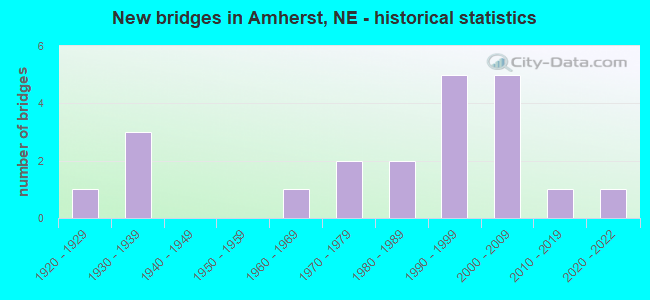
- New bridges - historical statistics
- 11920-1929
- 31930-1939
- 11960-1969
- 21970-1979
- 21980-1989
- 51990-1999
- 52000-2009
- 12010-2019
- 12020-2022

- Reconstructed bridges - Historical Statistics
- 11950-1959
- 01960-1969
- 01970-1979
- 11980-1989

- Bridge Condition - Deck
- 12.5%Excellent
- 18.8%Very good
- 6.3%Good
- 12.5%Satisfactory
- 50.0%Fair

- Bridge Condition - Superstructure
- 12.5%Excellent
- 18.8%Very good
- 18.8%Good
- 6.3%Satisfactory
- 43.8%Fair

- Bridge Condition - Substructure
- 18.8%Excellent
- 31.3%Very good
- 31.3%Good
- 6.3%Satisfactory
- 12.5%Fair

- Bridge Condition - Channel
- 19.0%Excellent
- 33.3%Very good
- 19.0%Good
- 19.0%Satisfactory
- 4.8%Fair
- 4.8%Poor

- Bridge Condition - Culverts
- 40.0%Excellent
- 20.0%Very good
- 40.0%Good
Find on map >> Show street view
Structure Number: C001001115, Location: 3W .2N OF AMHERST (Lat: 40.847300, Lng: -99.331300), Route carried "on" structure: County highway 11, Year Built: 1965, Status: Posted for load, Structure Length: 1.13m (3.71ft), Average Daily Traffic: 5 (year 2003), Average Future Daily Traffic: 8 (year 2033), Features Intersected: STREAM, Facility Carried by Structure: COUNTY HIGHWAY
Minimum Vertical Clearance: 30+ m (98+ ft), Kilometerpoint: 0.000, Lanes on structure: 2, Owner: County Highway Agency, Approaching Roadway Width: 7.0m (23.0ft), Material/Design: Steel, Design/Construction: Stringer/Multi-beam, Number Of Spans In Main Unit: 1, Length of Maximum Span: 10.7m (35.1ft), Curb-To-Curb Width: 5.3m (17.4ft), Out-to-Out Width: 5.5m (18.0ft)
Condition: Deck: Satisfactory, Superstructure: Satisfactory, Substructure: Satisfactory, Channel: Satisfactory, Operating Rating: 8.0 metric tons, Method Used To Determine Operating Rating: Load Factor (LF), Inventory Rating: 5.0 metric tons, Method Used To Determine Inventory Rating: Load Factor (LF), Structural Evaluation: High priority of replacement, Deck Geometry: High priority of corrective action, Waterway Adequacy: Equal to present minimum criteria, Approach Roadway Alignment: Better than present minimum criteria, Bridge Posting: Required (Relationship of Operating Rating to Maximum Legal Load: > 39.9% below), Length Of Structure Improvement: 1.13m (3.71ft), Designated Inspection Frequency: Every 24 months, Inspection Date: October 2021, Deck Structure Type: Corrugated Steel, Wearing Surface/Protective System: Wearing Surface: Other
Find on map >> Show street view
Structure Number: C00100192, Location: JCT US30/L-10B 8.3N (Lat: 40.821300, Lng: -99.255200), Route carried "on" structure: County highway 1865, Year Built: 1971, Status: Open, Structure Length: 3.38m (11.09ft), Average Daily Traffic: 275 (year 2011), Average Future Daily Traffic: 275 (year 2033), Design Load: H 15, Features Intersected: WOOD RIVER
Minimum Vertical Clearance: 30+ m (98+ ft), Kilometerpoint: 0.066, Lanes on structure: 2, Owner: County Highway Agency, Approaching Roadway Width: 9.1m (29.9ft), Skew: 1 degrees, Material/Design: Concrete continuous, Design/Construction: Slab, Number Of Spans In Main Unit: 3, Length of Maximum Span: 12.8m (42.0ft), Curb or Sidewalk Widths: Left: 0.5m (1.6ft), Right: 0.5m (1.6ft), Curb-To-Curb Width: 8.5m (27.9ft), Out-to-Out Width: 9.4m (30.8ft)
Condition: Deck: Excellent, Superstructure: Excellent, Substructure: Very good, Channel: Good, Operating Rating: 33.0 metric tons, Method Used To Determine Operating Rating: Field evaluation and documented engineering judgment, Inventory Rating: 22.0 metric tons, Method Used To Determine Inventory Rating: Field evaluation and documented engineering judgment, Structural Evaluation: Equal to present minimum criteria, Deck Geometry: Equal to present minimum criteria, Waterway Adequacy: Equal to present desirable criteria, Approach Roadway Alignment: Equal to present desirable criteria, Designated Inspection Frequency: Every 24 months, Inspection Date: October 2020
Find on map >> Show street view
Structure Number: C001002115, Location: 2E 1.7S OF AMHERST (Lat: 40.803300, Lng: -99.236700), Route carried "on" structure: County highway 21, Year Built: 1996, Status: Open, Structure Length: 1.89m (6.20ft), Average Daily Traffic: 20 (year 2003), Average Future Daily Traffic: 34 (year 2033), Design Load: HS 20, Features Intersected: WOOD RIVER, Facility Carried by Structure: COUNTY HIGHWAY
Minimum Vertical Clearance: 30+ m (98+ ft), Kilometerpoint: 0.000, Lanes on structure: 2, Owner: County Highway Agency, Approaching Roadway Width: 9.1m (29.9ft), Skew: 2 degrees, Material/Design: Concrete, Design/Construction: Stringer/Multi-beam, Number Of Spans In Main Unit: 2, Length of Maximum Span: 10.4m (34.1ft), Curb-To-Curb Width: 9.2m (30.2ft), Out-to-Out Width: 9.6m (31.5ft)
Condition: Deck: Fair, Superstructure: Fair, Substructure: Very good, Channel: Excellent, Operating Rating: 54.0 metric tons, Method Used To Determine Operating Rating: Load Factor (LF), Inventory Rating: 32.0 metric tons, Method Used To Determine Inventory Rating: Load Factor (LF), Structural Evaluation: Somewhat better than minimum adequacy, Deck Geometry: Better than present minimum criteria, Waterway Adequacy: Superior to present desirable criteria, Approach Roadway Alignment: Equal to present desirable criteria, Designated Inspection Frequency: Every 24 months, Inspection Date: October 2020, Deck Structure Type: Concrete Precast Panels, Wearing Surface/Protective System: Wearing Surface: Monolithic Concrete, Deck Protection: Galvanized Reinforcing
Find on map >> Show street view
Structure Number: C001002605P, Location: 2NW OF AMHERST (Lat: 40.866100, Lng: -99.306400), Route carried "on" structure: County highway 28C, Year Built: 2007, Status: Open, Structure Length: 2.19m (7.19ft), Average Daily Traffic: 40 (year 1998), Truck Traffic: 2%, Average Future Daily Traffic: 68 (year 2033), Features Intersected: WOOD RIVER
Minimum Vertical Clearance: 30+ m (98+ ft), Kilometerpoint: 0.763, Lanes on structure: 2, Owner: County Highway Agency, Approaching Roadway Width: 9.1m (29.9ft), Skew: 4 degrees, Material/Design: Concrete, Design/Construction: Stringer/Multi-beam, Number Of Spans In Main Unit: 3, Length of Maximum Span: 9.8m (32.2ft), Curb-To-Curb Width: 9.3m (30.5ft), Out-to-Out Width: 9.6m (31.5ft)
Condition: Deck: Fair, Superstructure: Fair, Substructure: Excellent, Channel: Very good, Operating Rating: 54.0 metric tons, Method Used To Determine Operating Rating: Load Factor (LF), Inventory Rating: 32.0 metric tons, Method Used To Determine Inventory Rating: Load Factor (LF), Structural Evaluation: Somewhat better than minimum adequacy, Deck Geometry: Better than present minimum criteria, Waterway Adequacy: Equal to present desirable criteria, Approach Roadway Alignment: Equal to present desirable criteria, Length Of Structure Improvement: 1.83m (6.00ft), Designated Inspection Frequency: Every 24 months, Inspection Date: April 2020, Deck Structure Type: Concrete Precast Panels, Wearing Surface/Protective System: Wearing Surface: Monolithic Concrete, Membrane: Built-up, Deck Protection: Galvanized Reinforcing
Find on map >> Show street view
Structure Number: C001003005, Location: 3W OF AMHERST (Lat: 40.844200, Lng: -99.327600), Route carried "on" structure: County highway 30, Year Built: 1975, Status: Posted for load, Structure Length: 1.22m (4.00ft), Average Daily Traffic: 40 (year 2003), Average Future Daily Traffic: 68 (year 2033), Features Intersected: STREAM, Facility Carried by Structure: COUNTY HIGHWAY
Minimum Vertical Clearance: 30+ m (98+ ft), Kilometerpoint: 0.000, Lanes on structure: 2, Owner: County Highway Agency, Approaching Roadway Width: 9.1m (29.9ft), Material/Design: Steel, Design/Construction: Stringer/Multi-beam, Number Of Spans In Main Unit: 1, Length of Maximum Span: 11.9m (39.0ft), Curb-To-Curb Width: 7.8m (25.6ft), Out-to-Out Width: 8.0m (26.2ft)
Condition: Deck: Fair, Superstructure: Good, Substructure: Good, Channel: Very good, Operating Rating: 15.0 metric tons, Method Used To Determine Operating Rating: Load Factor (LF), Inventory Rating: 9.0 metric tons, Method Used To Determine Inventory Rating: Load Factor (LF), Structural Evaluation: High priority of replacement, Deck Geometry: Equal to present minimum criteria, Waterway Adequacy: Better than present minimum criteria, Approach Roadway Alignment: Equal to present desirable criteria, Bridge Posting: Required (Relationship of Operating Rating to Maximum Legal Load: > 39.9% below), Length Of Structure Improvement: 1.22m (4.00ft), Designated Inspection Frequency: Every 24 months, Inspection Date: November 2021, Deck Structure Type: Concrete Cast-file-Place, Wearing Surface/Protective System: Wearing Surface: Gravel
Find on map >> Show street view
Structure Number: C00100301, Location: 1NW OF AMHERST (Lat: 40.843300, Lng: -99.288300), Route carried "on" structure: County highway 30, Year Built: 2004, Status: Open, Structure Length: 2.13m (6.99ft), Average Daily Traffic: 80 (year 2003), Truck Traffic: 6%, Average Future Daily Traffic: 136 (year 2033), Design Load: HS 20, Features Intersected: WOOD RIVER, Facility Carried by Structure: COUNTY HIGHWAY
Minimum Vertical Clearance: 30+ m (98+ ft), Kilometerpoint: 0.000, Lanes on structure: 2, Owner: County Highway Agency, Approaching Roadway Width: 8.5m (27.9ft), Material/Design: Concrete, Design/Construction: Stringer/Multi-beam, Number Of Spans In Main Unit: 3, Length of Maximum Span: 8.8m (28.9ft), Curb-To-Curb Width: 9.2m (30.2ft), Out-to-Out Width: 9.6m (31.5ft)
Condition: Deck: Fair, Superstructure: Fair, Substructure: Excellent, Channel: Very good, Operating Rating: 60.0 metric tons, Method Used To Determine Operating Rating: Load Factor (LF), Inventory Rating: 35.0 metric tons, Method Used To Determine Inventory Rating: Load Factor (LF), Structural Evaluation: Somewhat better than minimum adequacy, Deck Geometry: Better than present minimum criteria, Waterway Adequacy: Superior to present desirable criteria, Approach Roadway Alignment: Equal to present desirable criteria, Designated Inspection Frequency: Every 24 months, Inspection Date: September 2020, Deck Structure Type: Concrete Precast Panels, Wearing Surface/Protective System: Membrane: Built-up, Deck Protection: Galvanized Reinforcing
Find on map >> Show street view
Structure Number: C001003425, Location: 1.5S 2.5W OF AMHERST (Lat: 40.815400, Lng: -99.320800), Route carried "on" structure: County highway 7382, Year Built: 2021, Status: Open, Structure Length: 0.65m (2.13ft), Average Daily Traffic: 55 (year 1998), Average Future Daily Traffic: 93 (year 2033), Features Intersected: WOOD RIVER TRIB, Facility Carried by Structure: 145TH RD
Minimum Vertical Clearance: 30+ m (98+ ft), Kilometerpoint: 1.220, Lanes on structure: 2, Owner: County Highway Agency, Approaching Roadway Width: 8.5m (27.9ft), Skew: 1 degrees, Material/Design: Concrete, Design/Construction: Culvert, Number Of Spans In Main Unit: 2, Length of Maximum Span: 3.2m (10.5ft)
Condition: Channel: Satisfactory, Culverts: Excellent, Operating Rating: 50.0 metric tons, Method Used To Determine Operating Rating: Load Factor (LF), Inventory Rating: 30.0 metric tons, Method Used To Determine Inventory Rating: Load Factor (LF), Structural Evaluation: Better than present minimum criteria, Waterway Adequacy: Equal to present minimum criteria, Approach Roadway Alignment: Equal to present desirable criteria, Designated Inspection Frequency: Every 24 months, Inspection Date: May 2021
Find on map >> Show street view
Structure Number: C001003435, Location: 1.5S .2E OF AMHERST (Lat: 40.815400, Lng: -99.269900), Route carried "on" structure: County highway 7382, Year Built: 1995, Status: Open, Structure Length: 0.94m (3.08ft), Average Daily Traffic: 55 (year 1998), Average Future Daily Traffic: 93 (year 2033), Design Load: HS 20, Features Intersected: WOOD RIVER TRIBUTARY
Minimum Vertical Clearance: 30+ m (98+ ft), Kilometerpoint: 1.650, Lanes on structure: 2, Owner: County Highway Agency, Approaching Roadway Width: 9.1m (29.9ft), Material/Design: Concrete, Design/Construction: Stringer/Multi-beam, Number Of Spans In Main Unit: 1, Length of Maximum Span: 9.1m (29.9ft), Curb-To-Curb Width: 9.2m (30.2ft), Out-to-Out Width: 9.5m (31.2ft)
Condition: Deck: Fair, Superstructure: Fair, Substructure: Very good, Channel: Excellent, Operating Rating: 57.0 metric tons, Method Used To Determine Operating Rating: Load Factor (LF), Inventory Rating: 34.0 metric tons, Method Used To Determine Inventory Rating: Load Factor (LF), Structural Evaluation: Somewhat better than minimum adequacy, Deck Geometry: Better than present minimum criteria, Waterway Adequacy: Superior to present desirable criteria, Approach Roadway Alignment: Equal to present desirable criteria, Designated Inspection Frequency: Every 24 months, Inspection Date: October 2021, Deck Structure Type: Concrete Precast Panels, Wearing Surface/Protective System: Wearing Surface: Monolithic Concrete, Deck Protection: Galvanized Reinforcing
Find on map >> Show street view
Structure Number: C00100344, Location: 1.5S 1.5E OF AMHERST (Lat: 40.815000, Lng: -99.245000), Route carried "on" structure: County highway 34, Year Built: 1986, Status: Open, Structure Length: 1.83m (6.00ft), Average Daily Traffic: 40 (year 2003), Average Future Daily Traffic: 68 (year 2033), Features Intersected: WOOD RIVER, Facility Carried by Structure: COUNTY HIGHWAY
Minimum Vertical Clearance: 30+ m (98+ ft), Kilometerpoint: 0.000, Lanes on structure: 2, Owner: County Highway Agency, Approaching Roadway Width: 9.4m (30.8ft), Material/Design: Steel, Design/Construction: Stringer/Multi-beam, Number Of Spans In Main Unit: 1, Length of Maximum Span: 17.7m (58.1ft), Curb-To-Curb Width: 8.8m (28.9ft), Out-to-Out Width: 9.1m (29.9ft)
Condition: Deck: Fair, Superstructure: Very good, Substructure: Good, Channel: Satisfactory, Operating Rating: 65.0 metric tons, Method Used To Determine Operating Rating: Load Factor (LF), Inventory Rating: 39.0 metric tons, Method Used To Determine Inventory Rating: Load Factor (LF), Structural Evaluation: Better than present minimum criteria, Deck Geometry: Better than present minimum criteria, Waterway Adequacy: Equal to present minimum criteria, Approach Roadway Alignment: Equal to present desirable criteria, Length Of Structure Improvement: 1.83m (6.00ft), Designated Inspection Frequency: Every 24 months, Inspection Date: October 2021, Deck Structure Type: Concrete Cast-file-Place, Wearing Surface/Protective System: Wearing Surface: Gravel
Find on map >> Show street view
Structure Number: C001003443, Location: 2N 4.3W OF KEARNEY (Lat: 40.815000, Lng: -99.238300), Route carried "on" structure: County highway 34, Year Built: 1995, Status: Open, Structure Length: 0.76m (2.49ft), Average Daily Traffic: 40 (year 2003), Average Future Daily Traffic: 68 (year 2033), Design Load: HS 20, Features Intersected: STREAM, Facility Carried by Structure: COUNTY HIGHWAY
Minimum Vertical Clearance: 30+ m (98+ ft), Kilometerpoint: 0.000, Lanes on structure: 2, Owner: County Highway Agency, Approaching Roadway Width: 9.1m (29.9ft), Material/Design: Concrete, Design/Construction: Stringer/Multi-beam, Number Of Spans In Main Unit: 1, Length of Maximum Span: 7.3m (24.0ft), Curb-To-Curb Width: 9.2m (30.2ft), Out-to-Out Width: 9.5m (31.2ft)
Condition: Deck: Fair, Superstructure: Fair, Substructure: Very good, Channel: Excellent, Operating Rating: 71.0 metric tons, Method Used To Determine Operating Rating: Load Factor (LF), Inventory Rating: 43.0 metric tons, Method Used To Determine Inventory Rating: Load Factor (LF), Structural Evaluation: Somewhat better than minimum adequacy, Deck Geometry: Better than present minimum criteria, Waterway Adequacy: Superior to present desirable criteria, Approach Roadway Alignment: Equal to present desirable criteria, Designated Inspection Frequency: Every 24 months, Inspection Date: October 2021, Deck Structure Type: Concrete Precast Panels, Wearing Surface/Protective System: Wearing Surface: Monolithic Concrete
Find on map >> Show street view
Structure Number: C00101151, Location: .2S 1W .2S OF AMHERST (Lat: 40.825000, Lng: -99.293300), Route carried "on" structure: County highway 115, Year Built: 2011, Status: Open, Structure Length: 0.64m (2.10ft), Average Daily Traffic: 30 (year 2003), Average Future Daily Traffic: 35 (year 2033), Features Intersected: STREAM, Facility Carried by Structure: COUNTY HIGHWAY
Minimum Vertical Clearance: 30+ m (98+ ft), Kilometerpoint: 0.000, Lanes on structure: 2, Owner: County Highway Agency, Approaching Roadway Width: 8.5m (27.9ft), Material/Design: Concrete, Design/Construction: Culvert, Number Of Spans In Main Unit: 2, Length of Maximum Span: 3.0m (9.8ft)
Condition: Channel: Very good, Culverts: Excellent, Operating Rating: 42.0 metric tons, Method Used To Determine Operating Rating: Field evaluation and documented engineering judgment, Inventory Rating: 33.0 metric tons, Method Used To Determine Inventory Rating: Field evaluation and documented engineering judgment, Structural Evaluation: Superior to present desirable criteria, Waterway Adequacy: Superior to present desirable criteria, Approach Roadway Alignment: Equal to present desirable criteria, Length Of Structure Improvement: 0.98m (3.22ft), Designated Inspection Frequency: Every 24 months, Inspection Date: November 2021
Find on map >> Show street view
Structure Number: C001011715, Location: 2S OF AMHERST (Lat: 40.801700, Lng: -99.273300), Route carried "on" structure: County highway 117, Year Built: 2004, Status: Open, Structure Length: 0.73m (2.40ft), Average Daily Traffic: 25 (year 2003), Average Future Daily Traffic: 42 (year 2033), Design Load: HS 20, Features Intersected: STREAM, Facility Carried by Structure: COUNTY HIGHWAY
Minimum Vertical Clearance: 30+ m (98+ ft), Kilometerpoint: 0.000, Lanes on structure: 2, Owner: County Highway Agency, Approaching Roadway Width: 9.1m (29.9ft), Material/Design: Concrete, Design/Construction: Stringer/Multi-beam, Number Of Spans In Main Unit: 1, Length of Maximum Span: 7.0m (23.0ft), Curb-To-Curb Width: 9.2m (30.2ft), Out-to-Out Width: 9.6m (31.5ft)
Condition: Deck: Excellent, Superstructure: Excellent, Substructure: Excellent, Channel: Very good, Operating Rating: 78.0 metric tons, Method Used To Determine Operating Rating: Load Factor (LF), Inventory Rating: 47.0 metric tons, Method Used To Determine Inventory Rating: Load Factor (LF), Structural Evaluation: Superior to present desirable criteria, Deck Geometry: Better than present minimum criteria, Waterway Adequacy: Superior to present desirable criteria, Approach Roadway Alignment: Equal to present desirable criteria, Designated Inspection Frequency: Every 24 months, Inspection Date: October 2020, Deck Structure Type: Concrete Precast Panels, Wearing Surface/Protective System: Wearing Surface: Monolithic Concrete, Deck Protection: Galvanized Reinforcing
Find on map >> Show street view
Structure Number: C00101172, Location: .2S OF AMHERST (Lat: 40.831700, Lng: -99.273300), Route carried "on" structure: County highway 117, Year Built: 2006, Status: Open, Structure Length: 3.51m (11.52ft), Average Daily Traffic: 110 (year 2003), Truck Traffic: 15%, Average Future Daily Traffic: 187 (year 2033), Design Load: HS 20, Features Intersected: WOOD RIVER, Facility Carried by Structure: COUNTY HIGHWAY
Minimum Vertical Clearance: 30+ m (98+ ft), Kilometerpoint: 0.000, Lanes on structure: 2, Owner: County Highway Agency, Approaching Roadway Width: 9.1m (29.9ft), Skew: 1 degrees, Material/Design: Concrete continuous, Design/Construction: Slab, Number Of Spans In Main Unit: 3, Length of Maximum Span: 14.0m (45.9ft), Curb-To-Curb Width: 8.5m (27.9ft), Out-to-Out Width: 9.3m (30.5ft)
Condition: Deck: Very good, Superstructure: Very good, Substructure: Very good, Channel: Excellent, Operating Rating: 76.0 metric tons, Method Used To Determine Operating Rating: Load Factor (LF), Inventory Rating: 46.0 metric tons, Method Used To Determine Inventory Rating: Load Factor (LF), Structural Evaluation: Equal to present desirable criteria, Deck Geometry: Equal to present minimum criteria, Waterway Adequacy: Superior to present desirable criteria, Approach Roadway Alignment: Equal to present desirable criteria, Length Of Structure Improvement: 2.13m (6.99ft), Designated Inspection Frequency: Every 24 months, Inspection Date: June 2021, Deck Structure Type: Concrete Cast-file-Place, Wearing Surface/Protective System: Wearing Surface: Monolithic Concrete
Find on map >> Show street view
Structure Number: C001012815, Location: 1.4 N AMHERST (Lat: 40.858900, Lng: -99.274000), Route carried "on" structure: County highway 128, Year Built: 1925, Status: Posted for load, Structure Length: 0.73m (2.40ft), Average Daily Traffic: 3 (year 2003), Average Future Daily Traffic: 5 (year 2033), Features Intersected: STREAM, Facility Carried by Structure: COUNTY ROAD
Minimum Vertical Clearance: 30+ m (98+ ft), Kilometerpoint: 0.000, Lanes on structure: 2, Owner: County Highway Agency, Approaching Roadway Width: 6.1m (20.0ft), Material/Design: Wood or Timber, Design/Construction: Stringer/Multi-beam, Number Of Spans In Main Unit: 1, Length of Maximum Span: 7.0m (23.0ft), Curb-To-Curb Width: 6.1m (20.0ft), Out-to-Out Width: 6.2m (20.3ft)
Condition: Deck: Satisfactory, Superstructure: Fair, Substructure: Fair, Channel: Fair, Operating Rating: 17.0 metric tons, Method Used To Determine Operating Rating: Allowable Stress (AS), Inventory Rating: 12.0 metric tons, Method Used To Determine Inventory Rating: Allowable Stress (AS), Structural Evaluation: Meets minimum limits, Deck Geometry: Somewhat better than minimum adequacy, Waterway Adequacy: Somewhat better than minimum adequacy, Approach Roadway Alignment: Equal to present minimum criteria, Bridge Posting: Required (Relationship of Operating Rating to Maximum Legal Load: > 39.9% below), Length Of Structure Improvement: 0.76m (2.49ft), Designated Inspection Frequency: Every 24 months, Inspection Date: November 2021, Deck Structure Type: Wood or Timber, Wearing Surface/Protective System: Wearing Surface: Wood or Timber
Find on map >> Show street view
Structure Number: C001021725, Location: JCT N10/N40 7.8N 10.1W (Lat: 40.860800, Lng: -99.274300), Route carried "on" structure: County highway 2035, Year Built: 1981, Status: Open, Structure Length: 0.73m (2.40ft), Average Daily Traffic: 110 (year 2011), Average Future Daily Traffic: 110 (year 2033), Features Intersected: STREAM
Minimum Vertical Clearance: 30+ m (98+ ft), Kilometerpoint: 2.422, Lanes on structure: 2, Owner: County Highway Agency, Approaching Roadway Width: 9.1m (29.9ft), Material/Design: Steel, Design/Construction: Stringer/Multi-beam, Number Of Spans In Main Unit: 1, Length of Maximum Span: 7.3m (24.0ft), Curb-To-Curb Width: 8.3m (27.2ft), Out-to-Out Width: 8.6m (28.2ft)
Condition: Deck: Very good, Superstructure: Good, Substructure: Good, Channel: Poor, Operating Rating: 62.0 metric tons, Method Used To Determine Operating Rating: Load Factor (LF), Inventory Rating: 36.0 metric tons, Method Used To Determine Inventory Rating: Load Factor (LF), Structural Evaluation: Better than present minimum criteria, Deck Geometry: Somewhat better than minimum adequacy, Waterway Adequacy: Equal to present desirable criteria, Approach Roadway Alignment: Equal to present desirable criteria, Designated Inspection Frequency: Every 24 months, Inspection Date: November 2021, Deck Structure Type: Corrugated Steel, Wearing Surface/Protective System: Wearing Surface: Gravel
Find on map >> Show street view
Structure Number: M0055C3005, Location: AMHERST JEFFERSON @ ELM (Lat: 40.839500, Lng: -99.273200), Route carried "on" structure: City street C30, Year Built: 1935, Status: Posted for load, Structure Length: 1.01m (3.31ft), Average Daily Traffic: 80 (year 2003), Average Future Daily Traffic: 116 (year 2033), Features Intersected: STREAM, Facility Carried by Structure: JEFFERSON STREET
Minimum Vertical Clearance: 30+ m (98+ ft), Kilometerpoint: 0.000, Lanes on structure: 2, Owner: City or Municipal Highway Agency, Approaching Roadway Width: 9.4m (30.8ft), Material/Design: Steel, Design/Construction: Stringer/Multi-beam, Number Of Spans In Main Unit: 1, Length of Maximum Span: 9.4m (30.8ft), Curb-To-Curb Width: 6.0m (19.7ft), Out-to-Out Width: 6.1m (20.0ft)
Condition: Deck: Good, Superstructure: Good, Substructure: Good, Channel: Good, Operating Rating: 19.0 metric tons, Method Used To Determine Operating Rating: Load Factor (LF), Inventory Rating: 11.0 metric tons, Method Used To Determine Inventory Rating: Load Factor (LF), Structural Evaluation: Meets minimum limits, Deck Geometry: Meets minimum limits, Waterway Adequacy: Equal to present minimum criteria, Approach Roadway Alignment: Equal to present minimum criteria, Bridge Posting: Required (Relationship of Operating Rating to Maximum Legal Load: > 39.9% below), Length Of Structure Improvement: 1.01m (3.31ft), Designated Inspection Frequency: Every 24 months, Inspection Date: November 2021, Deck Structure Type: Corrugated Steel, Wearing Surface/Protective System: Wearing Surface: Gravel
Find on map >> Show street view
Structure Number: S040 07115, Location: 4NW AMHERST (Lat: 40.876000, Lng: -99.313400), Route carried "on" structure: State highway 40, Year Built: 2004, Status: Open, Structure Length: 4.63m (15.19ft), Average Daily Traffic: 1,135 (year 2018), Truck Traffic: 4%, Average Future Daily Traffic: 1,589 (year 2038), Design Load: HL 93, Features Intersected: WOOD RIVER
Minimum Vertical Clearance: 30+ m (98+ ft), Kilometerpoint: 11.450, Lanes on structure: 2, Base Highway Network: Yes, Owner: State Highway Agency, Approaching Roadway Width: 12.2m (40.0ft), Skew: 1 degrees, Material/Design: Steel continuous, Design/Construction: Stringer/Multi-beam, Number Of Spans In Main Unit: 3, Length of Maximum Span: 21.3m (69.9ft), Curb-To-Curb Width: 12.2m (40.0ft), Out-to-Out Width: 12.9m (42.3ft)
Condition: Deck: Very good, Superstructure: Very good, Substructure: Good, Channel: Very good, Operating Rating: 43.0 metric tons, Method Used To Determine Operating Rating: Load and Resistance Factor (LRFR), Inventory Rating: 33.0 metric tons, Method Used To Determine Inventory Rating: Load and Resistance Factor (LRFR), Structural Evaluation: Better than present minimum criteria, Deck Geometry: Better than present minimum criteria, Waterway Adequacy: Superior to present desirable criteria, Approach Roadway Alignment: Equal to present desirable criteria, Designated Inspection Frequency: Every 24 months, Inspection Date: August 2021, Deck Structure Type: Concrete Cast-file-Place, Wearing Surface/Protective System: Wearing Surface: Monolithic Concrete, Deck Protection: Epoxy Coated Reinforcing
Find on map >> Show street view
Structure Number: S040 07244, Location: 3NW AMHERST (Lat: 40.861300, Lng: -99.298200), Route carried "on" structure: State highway 40, Year Built: 1935, Year Reconstructed: 1962, Status: Open, Structure Length: 1.52m (4.99ft), Average Daily Traffic: 1,135 (year 2018), Truck Traffic: 4%, Average Future Daily Traffic: 1,589 (year 2038), Design Load: H 20, Features Intersected: STREAM
Minimum Vertical Clearance: 30+ m (98+ ft), Kilometerpoint: 11.658, Lanes on structure: 2, Base Highway Network: Yes, Owner: State Highway Agency, Approaching Roadway Width: 7.6m (24.9ft), Material/Design: Concrete, Design/Construction: Slab, Number Of Spans In Main Unit: 3, Length of Maximum Span: 4.9m (16.1ft), Curb or Sidewalk Widths: Left: 0.3m (1.0ft), Right: 0.3m (1.0ft), Curb-To-Curb Width: 10.4m (34.1ft), Out-to-Out Width: 11.6m (38.1ft)
Condition: Deck: Fair, Superstructure: Fair, Substructure: Fair, Channel: Good, Operating Rating: 54.0 metric tons, Method Used To Determine Operating Rating: Load Factor (LF), Inventory Rating: 33.0 metric tons, Method Used To Determine Inventory Rating: Load Factor (LF), Structural Evaluation: Somewhat better than minimum adequacy, Deck Geometry: Equal to present minimum criteria, Waterway Adequacy: Equal to present desirable criteria, Approach Roadway Alignment: Equal to present desirable criteria, Length Of Structure Improvement: 1.52m (4.99ft), Designated Inspection Frequency: Every 24 months, Inspection Date: August 2021, Deck Structure Type: Concrete Cast-file-Place, Wearing Surface/Protective System: Wearing Surface: Monolithic Concrete
Find on map >> Show street view
Structure Number: S040 07447, Location: 0W AMHERST (Lat: 40.839200, Lng: -99.273500), Route carried "on" structure: State highway 40, Year Built: 1992, Status: Open, Structure Length: 0.94m (3.08ft), Average Daily Traffic: 1,565 (year 2018), Truck Traffic: 4%, Average Future Daily Traffic: 2,191 (year 2038), Design Load: H 15, Features Intersected: STREAM
Minimum Vertical Clearance: 30+ m (98+ ft), Kilometerpoint: 11.985, Lanes on structure: 2, Base Highway Network: Yes, Owner: State Highway Agency, Approaching Roadway Width: 7.3m (24.0ft), Material/Design: Concrete, Design/Construction: Culvert, Number Of Spans In Main Unit: 3, Length of Maximum Span: 3.0m (9.8ft)
Condition: Channel: Good, Culverts: Good, Operating Rating: 33.0 metric tons, Method Used To Determine Operating Rating: Field evaluation and documented engineering judgment, Inventory Rating: 22.0 metric tons, Method Used To Determine Inventory Rating: Field evaluation and documented engineering judgment, Structural Evaluation: Somewhat better than minimum adequacy, Waterway Adequacy: Equal to present desirable criteria, Approach Roadway Alignment: Equal to present desirable criteria, Designated Inspection Frequency: Every 24 months, Inspection Date: August 2021
Find on map >> Show street view
Structure Number: S040 07686, Location: 2SE AMHERST (Lat: 40.817200, Lng: -99.238200), Route carried "on" structure: State highway 40, Year Built: 1934, Year Reconstructed: 1992, Status: Open, Structure Length: 0.64m (2.10ft), Average Daily Traffic: 1,990 (year 2018), Truck Traffic: 4%, Average Future Daily Traffic: 3,085 (year 2038), Design Load: H 15, Features Intersected: WOOD RIVER TRIB
Minimum Vertical Clearance: 30+ m (98+ ft), Kilometerpoint: 12.369, Lanes on structure: 2, Base Highway Network: Yes, Owner: State Highway Agency, Approaching Roadway Width: 7.3m (24.0ft), Material/Design: Concrete, Design/Construction: Culvert, Number Of Spans In Main Unit: 2, Length of Maximum Span: 3.0m (9.8ft)
Condition: Channel: Satisfactory, Culverts: Good, Operating Rating: 33.0 metric tons, Method Used To Determine Operating Rating: Field evaluation and documented engineering judgment, Inventory Rating: 22.0 metric tons, Method Used To Determine Inventory Rating: Field evaluation and documented engineering judgment, Structural Evaluation: Somewhat better than minimum adequacy, Waterway Adequacy: Equal to present desirable criteria, Approach Roadway Alignment: Equal to present desirable criteria, Designated Inspection Frequency: Every 24 months, Inspection Date: August 2021
Find on map >> Show street view
Structure Number: S040 07765, Location: 3SE AMHERST (Lat: 40.811400, Lng: -99.225200), Route carried "on" structure: State highway 40, Year Built: 1992, Status: Open, Structure Length: 0.94m (3.08ft), Average Daily Traffic: 1,990 (year 2018), Truck Traffic: 4%, Average Future Daily Traffic: 3,085 (year 2038), Design Load: HS 20, Features Intersected: STREAM
Minimum Vertical Clearance: 30+ m (98+ ft), Kilometerpoint: 12.497, Lanes on structure: 2, Base Highway Network: Yes, Owner: State Highway Agency, Approaching Roadway Width: 7.3m (24.0ft), Material/Design: Concrete, Design/Construction: Culvert, Number Of Spans In Main Unit: 3, Length of Maximum Span: 3.0m (9.8ft)
Condition: Channel: Very good, Culverts: Very good, Operating Rating: 43.0 metric tons, Method Used To Determine Operating Rating: Field evaluation and documented engineering judgment, Inventory Rating: 33.0 metric tons, Method Used To Determine Inventory Rating: Field evaluation and documented engineering judgment, Structural Evaluation: Equal to present desirable criteria, Waterway Adequacy: Equal to present desirable criteria, Approach Roadway Alignment: Equal to present desirable criteria, Designated Inspection Frequency: Every 24 months, Inspection Date: August 2021