Bridge Statistics for Amboy, Washington (WA)
Condition, Traffic, Stress, Structural Evaluation, Project Costs
- National Bridge Inventory (NBI) Statistics
- 10Number of bridges
- 108ft / 33.2mTotal length
- $12,989,000Total costs
- 16,262Total average daily traffic
- 1,406Total average daily truck traffic
- 25,359Total future (year 2038) average daily traffic
- National Bridge Inventory (NBI) Registered Bridges for Amboy
- No street view available for this location
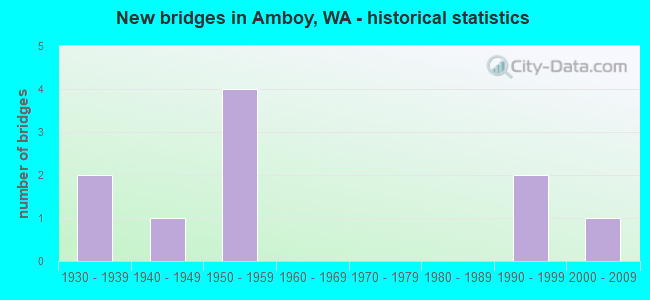
- New bridges - historical statistics
- 21930-1939
- 11940-1949
- 41950-1959
- 21990-1999
- 12000-2009


- Bridge Condition - Deck
- 22.2%Very good
- 44.4%Good
- 11.1%Satisfactory
- 11.1%Poor
- 11.1%Serious

- Bridge Condition - Superstructure
- 11.1%Very good
- 55.6%Good
- 22.2%Satisfactory
- 11.1%Fair

- Bridge Condition - Substructure
- 11.1%Very good
- 55.6%Good
- 22.2%Satisfactory
- 11.1%Fair

- Bridge Condition - Channel
- 50.0%Very good
- 40.0%Good
- 10.0%Satisfactory
Find on map >> Show street view
Structure Number: IU, Location: 19.8 N JCT SR 502 (Lat: 45.960311, Lng: -122.372467), Route carried "on" structure: State highway 503, Year Built: 1932, Year Reconstructed: 1957, Status: Posted for load, Structure Length: 13.96m (45.80ft), Average Daily Traffic: 1,083 (year 2019), Truck Traffic: 9%, Average Future Daily Traffic: 1,568 (year 2039), Design Load: H 10, Features Intersected: LEWIS RIVER
Minimum Vertical Clearance: 4.44m (14.57ft), Kilometerpoint: 44.788, Lanes on structure: 1, Base Highway Network: Yes, Owner: State Highway Agency, Approaching Roadway Width: 6.4m (21.0ft), Material/Design: Steel, Design/Construction: Suspension, Number Of Spans In Main Unit: 1, Number Of Approach Spans: 5, Length of Maximum Span: 91.4m (299.9ft), Curb-To-Curb Width: 5.1m (16.7ft), Out-to-Out Width: 6.1m (20.0ft)
Condition: Deck: Satisfactory, Superstructure: Fair, Substructure: Satisfactory, Channel: Very good, Operating Rating: 13.6 metric tons, Method Used To Determine Operating Rating: Load and Resistance Factor Rating (LRFR) rating reported by rating factor(RF) method using HL-93 loadings, Inventory Rating: 10.4 metric tons, Method Used To Determine Inventory Rating: Load and Resistance Factor Rating (LRFR) rating reported by rating factor(RF) method using HL-93 loadings, Structural Evaluation: High priority of corrective action, Deck Geometry: High priority of replacement, Waterway Adequacy: Equal to present desirable criteria, Approach Roadway Alignment: High priority of corrective action, Bridge Posting: Required (Relationship of Operating Rating to Maximum Legal Load: 10.0 - 19.9% below), Length Of Structure Improvement: 13.96m (45.80ft), Designated Inspection Frequency: Every 24 months, Critical Feature Inspection Frequency: Every 24 months, Underwater Inspection Frequency: Every 60 months, Other Special Inspection Frequency: Every 24 months, Inspection Date: March 2021, Critical Feature Inspection Date: March 2021, Underwater Inspection Date: July 2018, Other Special Inspection Date: March 2021, Bridge Improvement Cost: $2,107,000, Roadway Improvement Cost: $421,000, Total Project Cost: $4,214,000 ( Estimate for 2014), Deck Structure Type: Wood or Timber, Wearing Surface/Protective System: Wearing Surface: Bituminous
Find on map >> Show street view
Structure Number: MM, Location: 12.7 N JCT SR 502 (Lat: 45.911222, Lng: -122.446694), Route carried "on" structure: State highway 503, Year Built: 1953, Status: Open, Structure Length: 0.94m (3.08ft), Average Daily Traffic: 4,056 (year 2019), Truck Traffic: 7%, Average Future Daily Traffic: 5,873 (year 2039), Design Load: HS 20, Features Intersected: CHELATCHIE CREEK
Minimum Vertical Clearance: 30+ m (98+ ft), Kilometerpoint: 33.410, Lanes on structure: 2, Base Highway Network: Yes, Owner: State Highway Agency, Approaching Roadway Width: 9.1m (29.9ft), Material/Design: Steel, Design/Construction: Stringer/Multi-beam, Number Of Spans In Main Unit: 1, Length of Maximum Span: 8.5m (27.9ft), Curb or Sidewalk Widths: Left: 0.1m (0.3ft), Right: 0.0m, Curb-To-Curb Width: 9.1m (29.9ft), Out-to-Out Width: 9.4m (30.8ft)
Condition: Deck: Very good, Superstructure: Good, Substructure: Good, Channel: Very good, Operating Rating: 89.8 metric tons, Method Used To Determine Operating Rating: Load Factor (LF), Inventory Rating: 65.3 metric tons, Method Used To Determine Inventory Rating: Load Factor (LF), Structural Evaluation: Better than present minimum criteria, Deck Geometry: Meets minimum limits, Waterway Adequacy: Equal to present minimum criteria, Approach Roadway Alignment: Equal to present desirable criteria, Length Of Structure Improvement: 0.94m (3.08ft), Designated Inspection Frequency: Every 24 months, Inspection Date: September 2020, Bridge Improvement Cost: $198,000, Roadway Improvement Cost: $40,000, Total Project Cost: $397,000 ( Estimate for 2014), Deck Structure Type: Concrete Cast-file-Place, Wearing Surface/Protective System: Wearing Surface: Bituminous
Find on map >> Show street view
Structure Number: MN, Location: 13.5 N JCT SR 502 (Lat: 45.917150, Lng: -122.434983), Route carried "on" structure: State highway 503, Year Built: 1953, Status: Open, Structure Length: 0.76m (2.49ft), Average Daily Traffic: 822 (year 2019), Truck Traffic: 10%, Average Future Daily Traffic: 1,190 (year 2039), Design Load: HS 20, Features Intersected: N BRANCH CHELATCHIE CR
Minimum Vertical Clearance: 30+ m (98+ ft), Kilometerpoint: 34.730, Lanes on structure: 2, Base Highway Network: Yes, Owner: State Highway Agency, Approaching Roadway Width: 7.3m (24.0ft), Material/Design: Concrete, Design/Construction: Slab, Number Of Spans In Main Unit: 1, Length of Maximum Span: 6.7m (22.0ft), Curb or Sidewalk Widths: Left: 0.1m (0.3ft), Right: 0.1m (0.3ft), Curb-To-Curb Width: 7.9m (25.9ft), Out-to-Out Width: 8.6m (28.2ft)
Condition: Deck: Serious, Superstructure: Good, Substructure: Good, Channel: Good, Operating Rating: 52.6 metric tons, Method Used To Determine Operating Rating: Load Factor (LF), Inventory Rating: 31.7 metric tons, Method Used To Determine Inventory Rating: Load Factor (LF), Structural Evaluation: Better than present minimum criteria, Deck Geometry: Somewhat better than minimum adequacy, Waterway Adequacy: Equal to present minimum criteria, Approach Roadway Alignment: Equal to present desirable criteria, Length Of Structure Improvement: 0.76m (2.49ft), Designated Inspection Frequency: Every 24 months, Inspection Date: July 2021, Bridge Improvement Cost: $130,000, Roadway Improvement Cost: $26,000, Total Project Cost: $260,000 ( Estimate for 2014), Deck Structure Type: Concrete Cast-file-Place, Wearing Surface/Protective System: Wearing Surface: Bituminous, Membrane: Preformed Fabric
Find on map >> Show street view
Structure Number: MQ, Location: 16.4 N JCT SR 502 (Lat: 45.924361, Lng: -122.382889), Route carried "on" structure: State highway 503, Year Built: 1954, Status: Open, Structure Length: 0.64m (2.10ft), Average Daily Traffic: 2,212 (year 2019), Truck Traffic: 10%, Average Future Daily Traffic: 3,202 (year 2039), Design Load: HS 20, Features Intersected: CHELATCHIE CREEK
Minimum Vertical Clearance: 30+ m (98+ ft), Kilometerpoint: 39.348, Lanes on structure: 2, Base Highway Network: Yes, Owner: State Highway Agency, Approaching Roadway Width: 7.3m (24.0ft), Material/Design: Concrete, Design/Construction: Slab, Number Of Spans In Main Unit: 1, Length of Maximum Span: 5.5m (18.0ft), Curb or Sidewalk Widths: Left: 0.1m (0.3ft), Right: 0.1m (0.3ft), Curb-To-Curb Width: 7.9m (25.9ft), Out-to-Out Width: 8.4m (27.6ft)
Condition: Deck: Very good, Superstructure: Very good, Substructure: Good, Channel: Satisfactory, Operating Rating: 46.3 metric tons, Method Used To Determine Operating Rating: Load Factor (LF), Inventory Rating: 28.1 metric tons, Method Used To Determine Inventory Rating: Load Factor (LF), Structural Evaluation: Better than present minimum criteria, Deck Geometry: High priority of corrective action, Waterway Adequacy: Equal to present desirable criteria, Approach Roadway Alignment: Equal to present desirable criteria, Length Of Structure Improvement: 0.64m (2.10ft), Designated Inspection Frequency: Every 24 months, Inspection Date: September 2020, Bridge Improvement Cost: $109,000, Roadway Improvement Cost: $22,000, Total Project Cost: $218,000 ( Estimate for 2014), Deck Structure Type: Concrete Cast-file-Place, Wearing Surface/Protective System: Wearing Surface: Bituminous
Find on map >> Show street view
Structure Number: 2912A, Location: 11.7 N CLARK CO (Lat: 45.995833, Lng: -122.516278), Route carried "on" structure: State highway 503, Year Built: 1945, Status: Open, Structure Length: 9.39m (30.81ft), Average Daily Traffic: 1,240 (year 2019), Truck Traffic: 12%, Average Future Daily Traffic: 1,656 (year 2039), Design Load: H 15, Features Intersected: JIM CREEK
Minimum Vertical Clearance: 30+ m (98+ ft), Kilometerpoint: 63.650, Lanes on structure: 2, Base Highway Network: Yes, Owner: State Highway Agency, Approaching Roadway Width: 9.8m (32.2ft), Material/Design: Concrete, Design/Construction: Arch - Deck, Number Of Spans In Main Unit: 1, Number Of Approach Spans: 6, Length of Maximum Span: 54.6m (179.1ft), Curb-To-Curb Width: 7.3m (24.0ft), Out-to-Out Width: 9.1m (29.9ft)
Condition: Deck: Poor, Superstructure: Satisfactory, Substructure: Satisfactory, Channel: Very good, Operating Rating: 22.0 metric tons, Method Used To Determine Operating Rating: Load and Resistance Factor Rating (LRFR) rating reported by rating factor(RF) method using HL-93 loadings, Inventory Rating: 14.3 metric tons, Method Used To Determine Inventory Rating: Load and Resistance Factor Rating (LRFR) rating reported by rating factor(RF) method using HL-93 loadings, Structural Evaluation: Meets minimum limits, Deck Geometry: Meets minimum limits, Waterway Adequacy: Equal to present desirable criteria, Approach Roadway Alignment: Equal to present desirable criteria, Length Of Structure Improvement: 9.39m (30.81ft), Designated Inspection Frequency: Every 24 months, Inspection Date: April 2018, Bridge Improvement Cost: $2,094,000, Roadway Improvement Cost: $419,000, Total Project Cost: $4,189,000 ( Estimate for 2014), Deck Structure Type: Concrete Cast-file-Place, Wearing Surface/Protective System: Wearing Surface: Monolithic Concrete
Find on map >> Show street view
Structure Number: 6052A, Location: 12.6 N JCT SR 502 (Lat: 45.910139, Lng: -122.447250), Route carried "on" structure: State highway 503, Year Built: 1958, Status: Open, Structure Length: 1.07m (3.51ft), Average Daily Traffic: 4,056 (year 2019), Truck Traffic: 7%, Average Future Daily Traffic: 5,873 (year 2039), Features Intersected: CEDAR CREEK
Minimum Vertical Clearance: 30+ m (98+ ft), Kilometerpoint: 33.265, Lanes on structure: 2, Base Highway Network: Yes, Owner: State Highway Agency, Approaching Roadway Width: 7.3m (24.0ft), Material/Design: Concrete continuous, Design/Construction: Slab, Number Of Spans In Main Unit: 2, Length of Maximum Span: 5.2m (17.1ft), Curb or Sidewalk Widths: Left: 0.2m (0.7ft), Right: 0.7m (2.3ft), Curb-To-Curb Width: 6.1m (20.0ft), Out-to-Out Width: 6.9m (22.6ft)
Condition: Deck: Good, Superstructure: Good, Substructure: Good, Channel: Good, Operating Rating: 33.6 metric tons, Method Used To Determine Operating Rating: Load Factor (LF), Inventory Rating: 20.0 metric tons, Method Used To Determine Inventory Rating: Load Factor (LF), Structural Evaluation: Somewhat better than minimum adequacy, Deck Geometry: High priority of replacement, Waterway Adequacy: Equal to present desirable criteria, Approach Roadway Alignment: Equal to present minimum criteria, Length Of Structure Improvement: 1.07m (3.51ft), Designated Inspection Frequency: Every 24 months, Inspection Date: September 2020, Bridge Improvement Cost: $182,000, Roadway Improvement Cost: $36,000, Total Project Cost: $364,000 ( Estimate for 2014), Deck Structure Type: Concrete Cast-file-Place, Wearing Surface/Protective System: Wearing Surface: Bituminous
Find on map >> Show street view
Structure Number: 60301000003003, Location: AT MSHNVM HEADQUARTERS IN (Lat: 45.926686, Lng: -122.381114), Route carried "on" structure: Federal lands road 35110, Year Built: 2000, Status: Open, Structure Length: 1.52m (4.99ft), Average Daily Traffic: 35 (year 2006), Average Future Daily Traffic: 52 (year 2042), Design Load: H 20, Features Intersected: TRIB OF CHELATCHIE CRK
Minimum Vertical Clearance: 30+ m (98+ ft), Kilometerpoint: 0.158, Lanes on structure: 1, Owner: U.S. Forest Service, Approaching Roadway Width: 4.0m (13.1ft), Material/Design: Steel, Design/Construction: Stringer/Multi-beam, Number Of Spans In Main Unit: 1, Length of Maximum Span: 15.0m (49.2ft), Curb-To-Curb Width: 4.0m (13.1ft), Out-to-Out Width: 4.3m (14.1ft)
Condition: Deck: Good, Superstructure: Good, Substructure: Very good, Channel: Good, Deck Geometry: Somewhat better than minimum adequacy, Waterway Adequacy: Superior to present desirable criteria, Approach Roadway Alignment: Equal to present desirable criteria, Designated Inspection Frequency: Every 24 months, Inspection Date: June 2021, Deck Structure Type: Corrugated Steel, Wearing Surface/Protective System: Wearing Surface: Bituminous
Find on map >> Show street view
Structure Number: 82277, Location: JCT PUP & CEDAR CK (Lat: 45.931100, Lng: -122.528383), Route carried "on" structure: County highway 96160, Year Built: 1930, Year Reconstructed: 1955, Status: Open, Structure Length: 1.25m (4.10ft), Average Daily Traffic: 1,173 (year 2018), Truck Traffic: 18%, Average Future Daily Traffic: 2,000 (year 2038), Design Load: HS 15, Features Intersected: CEDAR CREEK, Facility Carried by Structure: CEDAR CREEK RD
Minimum Vertical Clearance: 30+ m (98+ ft), Kilometerpoint: 0.001, Lanes on structure: 2, Owner: County Highway Agency, Approaching Roadway Width: 7.9m (25.9ft), Material/Design: Concrete, Design/Construction: Stringer/Multi-beam, Number Of Spans In Main Unit: 1, Length of Maximum Span: 12.5m (41.0ft), Curb or Sidewalk Widths: Left: 0.2m (0.7ft), Right: 0.2m (0.7ft), Curb-To-Curb Width: 7.9m (25.9ft), Out-to-Out Width: 8.0m (26.2ft)
Condition: Deck: Good, Superstructure: Satisfactory, Substructure: Fair, Channel: Good, Operating Rating: 39.5 metric tons, Method Used To Determine Operating Rating: Load and Resistance Factor Rating (LRFR) rating reported by rating factor(RF) method using HL-93 loadings, Inventory Rating: 30.5 metric tons, Method Used To Determine Inventory Rating: Load and Resistance Factor Rating (LRFR) rating reported by rating factor(RF) method using HL-93 loadings, Structural Evaluation: Somewhat better than minimum adequacy, Deck Geometry: Meets minimum limits, Waterway Adequacy: Better than present minimum criteria, Approach Roadway Alignment: High priority of corrective action, Length Of Structure Improvement: 1.25m (4.10ft), Designated Inspection Frequency: Every 24 months, Inspection Date: June 2021, Bridge Improvement Cost: $230,000, Roadway Improvement Cost: $46,000, Total Project Cost: $459,000 ( Estimate for 2014), Deck Structure Type: Concrete Cast-file-Place, Wearing Surface/Protective System: Wearing Surface: Monolithic Concrete
Find on map >> Show street view
Structure Number: 86116, Location: 0.5N OF CEDAR CK RD (Lat: 45.938450, Lng: -122.583700), Route carried "on" structure: County highway 61630, Year Built: 1994, Status: Open, Structure Length: 2.59m (8.50ft), Average Daily Traffic: 102 (year 2017), Truck Traffic: 7%, Average Future Daily Traffic: 276 (year 2043), Design Load: HS 20, Features Intersected: CEDAR CREEK, Facility Carried by Structure: GRIST MILL RD
Minimum Vertical Clearance: 5.31m (17.42ft), Kilometerpoint: 0.001, Lanes on structure: 2, Owner: County Highway Agency, Approaching Roadway Width: 7.0m (23.0ft), Material/Design: Wood or Timber, Design/Construction: Truss - Thru, Number Of Spans In Main Unit: 1, Length of Maximum Span: 25.3m (83.0ft), Curb or Sidewalk Widths: Left: 0.0m, Right: 1.2m (3.9ft), Curb-To-Curb Width: 6.7m (22.0ft), Out-to-Out Width: 6.7m (22.0ft)
Condition: Deck: Good, Superstructure: Good, Substructure: Good, Channel: Very good, Operating Rating: 86.8 metric tons, Method Used To Determine Operating Rating: Load and Resistance Factor Rating (LRFR) rating reported by rating factor(RF) method using HL-93 loadings, Inventory Rating: 56.7 metric tons, Method Used To Determine Inventory Rating: Load and Resistance Factor Rating (LRFR) rating reported by rating factor(RF) method using HL-93 loadings, Structural Evaluation: Better than present minimum criteria, Deck Geometry: Meets minimum limits, Waterway Adequacy: Equal to present desirable criteria, Approach Roadway Alignment: Equal to present minimum criteria, Length Of Structure Improvement: 2.90m (9.51ft), Designated Inspection Frequency: Every 24 months, Inspection Date: January 2022, Bridge Improvement Cost: $1,444,000, Roadway Improvement Cost: $289,000, Total Project Cost: $2,888,000 ( Estimate for 2014), Deck Structure Type: Wood or Timber, Wearing Surface/Protective System: Wearing Surface: Bituminous
Find on map >> Show street view
Structure Number: 87092, Location: 0.5 M. N OF YACOLT ROAD (Lat: 45.873183, Lng: -122.409267), Route carried "on" structure: County highway 96200, Year Built: 1999, Status: Open, Structure Length: 1.07m (3.51ft), Average Daily Traffic: 1,483 (year 2017), Truck Traffic: 5%, Average Future Daily Traffic: 3,669 (year 2039), Design Load: H 20, Features Intersected: CEDAR CREEK, Facility Carried by Structure: Amboy Road
Minimum Vertical Clearance: 30+ m (98+ ft), Kilometerpoint: 0.001, Lanes on structure: 2, Owner: County Highway Agency, Approaching Roadway Width: 6.4m (21.0ft), Material/Design: Steel, Design/Construction: Culvert, Number Of Spans In Main Unit: 1, Length of Maximum Span: 10.7m (35.1ft), Curb-To-Curb Width: 7.3m (24.0ft), Out-to-Out Width: 7.3m (24.0ft)
Condition: Channel: Very good, Culverts: Good, Operating Rating: 51.8 metric tons, Method Used To Determine Operating Rating: Load and Resistance Factor Rating (LRFR) rating reported by rating factor(RF) method using HL-93 loadings, Inventory Rating: 40.2 metric tons, Method Used To Determine Inventory Rating: Load and Resistance Factor Rating (LRFR) rating reported by rating factor(RF) method using HL-93 loadings, Structural Evaluation: Better than present minimum criteria, Deck Geometry: Meets minimum limits, Waterway Adequacy: Equal to present desirable criteria, Approach Roadway Alignment: Equal to present desirable criteria, Designated Inspection Frequency: Every 24 months, Inspection Date: Febuary 2021