Bridge Statistics for Amber, Oklahoma (OK)
Condition, Traffic, Stress, Structural Evaluation, Project Costs
- National Bridge Inventory (NBI) Statistics
- 32Number of bridges
- 233ft / 70.7mTotal length
- $18,170,000Total costs
- 73,903Total average daily traffic
- 21,546Total average daily truck traffic
- National Bridge Inventory (NBI) Registered Bridges for Amber
- No street view available for this location
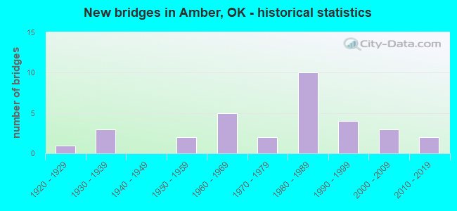
- New bridges - historical statistics
- 11920-1929
- 31930-1939
- 21950-1959
- 51960-1969
- 21970-1979
- 101980-1989
- 41990-1999
- 32000-2009
- 22010-2019

- Reconstructed bridges - Historical Statistics
- 21960-1969
- 01970-1979
- 01980-1989
- 21990-1999


- Bridge Condition - Deck
- 27.8%Good
- 66.7%Satisfactory
- 5.6%Failed

- Bridge Condition - Superstructure
- 22.2%Very good
- 27.8%Good
- 27.8%Satisfactory
- 16.7%Fair
- 5.6%Failed

- Bridge Condition - Substructure
- 11.1%Very good
- 22.2%Good
- 27.8%Satisfactory
- 33.3%Fair
- 5.6%Failed

- Bridge Condition - Channel
- 14.8%Very good
- 18.5%Good
- 29.6%Satisfactory
- 33.3%Fair
- 3.7%Poor

- Bridge Condition - Culverts
- 16.7%Very good
- 41.7%Good
- 25.0%Satisfactory
- 16.7%Fair
Find on map >> Show street view
Structure Number: 2007, Location: 0.5 MI W ALFALFA CO (Lat: 36.797250, Lng: -98.550267), Route carried "on" structure: US 64, Year Built: 1928, Year Reconstructed: 2003, Status: Open, Structure Length: 0.61m (2.00ft), Average Daily Traffic: 2,100 (year 2020), Truck Traffic: 16%, Average Future Daily Traffic: 3,360 (year 2040), Design Load: H 20, Features Intersected: CREEK
Minimum Vertical Clearance: 30+ m (98+ ft), Kilometerpoint: 8.785, Lanes on structure: 2, Base Highway Network: Yes, Owner: State Highway Agency, Approaching Roadway Width: 11.9m (39.0ft), Material/Design: Concrete, Design/Construction: Culvert, Number Of Spans In Main Unit: 3, Length of Maximum Span: 1.8m (5.9ft)
Condition: Channel: Good, Culverts: Very good, Operating Rating: 44.5 metric tons, Method Used To Determine Operating Rating: Allowable Stress (AS), Inventory Rating: 32.7 metric tons, Method Used To Determine Inventory Rating: Allowable Stress (AS), Structural Evaluation: Equal to present desirable criteria, Waterway Adequacy: Better than present minimum criteria, Approach Roadway Alignment: Equal to present desirable criteria, Length Of Structure Improvement: 0.61m (2.00ft), Designated Inspection Frequency: Every 24 months, Inspection Date: September 2021, Bridge Improvement Cost: $230,000, Roadway Improvement Cost: $380,000, Total Project Cost: $644,000 ( Estimate for 2015)
Find on map >> Show street view
Structure Number: 2417, Location: 3 N 6 W .9 S OF ROSS (Lat: 35.624469, Lng: -97.106114), Route carried "on" structure: County highway N3310, Year Built: 1930, Status: Temporarily open, Structure Length: 0.79m (2.59ft), Average Daily Traffic: 100 (year 2020), Truck Traffic: 10%, Average Future Daily Traffic: 160 (year 2040), Features Intersected: CREEK
Minimum Vertical Clearance: 30+ m (98+ ft), Kilometerpoint: 1.448, Lanes on structure: 2, Owner: County Highway Agency, Approaching Roadway Width: 7.6m (24.9ft), Material/Design: Wood or Timber, Design/Construction: Stringer/Multi-beam, Number Of Spans In Main Unit: 1, Length of Maximum Span: 7.0m (23.0ft), Curb-To-Curb Width: 4.9m (16.1ft), Out-to-Out Width: 4.9m (16.1ft)
Condition: Deck: Failed, Superstructure: Failed, Substructure: Failed, Channel: Good, Deck Geometry: High priority of corrective action, Waterway Adequacy: Better than present minimum criteria, Approach Roadway Alignment: Equal to present desirable criteria, Length Of Structure Improvement: 3.05m (10.01ft), Designated Inspection Frequency: Every 24 months, Inspection Date: May 2020, Bridge Improvement Cost: $156,000, Roadway Improvement Cost: $86,000, Total Project Cost: $246,000 ( Estimate for 2015), Deck Structure Type: Wood or Timber, Wearing Surface/Protective System: Wearing Surface: Wood or Timber
Find on map >> Show street view
Structure Number: 292, Location: 10.4 MI E DUTTON (Lat: 35.203644, Lng: -97.906472), Route carried "on" structure: County highway 2604C, Year Built: 1930, Year Reconstructed: 1965, Status: Posted for load, Structure Length: 1.28m (4.20ft), Average Daily Traffic: 330 (year 2020), Truck Traffic: 15%, Average Future Daily Traffic: 528 (year 2040), Design Load: H 15, Features Intersected: CREEK
Minimum Vertical Clearance: 30+ m (98+ ft), Kilometerpoint: 16.734, Lanes on structure: 2, Owner: County Highway Agency, Approaching Roadway Width: 6.7m (22.0ft), Material/Design: Steel, Design/Construction: Stringer/Multi-beam, Number Of Spans In Main Unit: 1, Length of Maximum Span: 12.2m (40.0ft), Curb-To-Curb Width: 7.6m (24.9ft), Out-to-Out Width: 8.1m (26.6ft)
Condition: Deck: Satisfactory, Superstructure: Fair, Substructure: Fair, Channel: Fair, Operating Rating: 19.1 metric tons, Method Used To Determine Operating Rating: Load Factor (LF), Inventory Rating: 10.9 metric tons, Method Used To Determine Inventory Rating: Load Factor (LF), Structural Evaluation: Meets minimum limits, Deck Geometry: Somewhat better than minimum adequacy, Waterway Adequacy: Better than present minimum criteria, Approach Roadway Alignment: Equal to present desirable criteria, Bridge Posting: Required (Relationship of Operating Rating to Maximum Legal Load: 30.0 - 39.9% below), Length Of Structure Improvement: 3.93m (12.89ft), Designated Inspection Frequency: Every 24 months, Inspection Date: September 2020, Bridge Improvement Cost: $201,000, Roadway Improvement Cost: $110,000, Total Project Cost: $319,000 ( Estimate for 2015), Deck Structure Type: Concrete Cast-file-Place, Wearing Surface/Protective System: Wearing Surface: Bituminous
Find on map >> Show street view
Structure Number: 2921, Location: .5 N 2.8 E OF POCASSET (Lat: 35.203622, Lng: -97.903767), Route carried "on" structure: County highway 2604C, Year Built: 1930, Year Reconstructed: 1995, Status: Posted for load, Structure Length: 1.28m (4.20ft), Average Daily Traffic: 330 (year 2020), Truck Traffic: 15%, Average Future Daily Traffic: 528 (year 2040), Design Load: H 15, Features Intersected: CREEK
Minimum Vertical Clearance: 30+ m (98+ ft), Kilometerpoint: 16.975, Lanes on structure: 2, Owner: County Highway Agency, Approaching Roadway Width: 6.7m (22.0ft), Material/Design: Steel, Design/Construction: Stringer/Multi-beam, Number Of Spans In Main Unit: 1, Length of Maximum Span: 12.2m (40.0ft), Curb-To-Curb Width: 7.6m (24.9ft), Out-to-Out Width: 8.1m (26.6ft)
Condition: Deck: Satisfactory, Superstructure: Fair, Substructure: Fair, Channel: Fair, Operating Rating: 21.8 metric tons, Method Used To Determine Operating Rating: Load Factor (LF), Inventory Rating: 12.7 metric tons, Method Used To Determine Inventory Rating: Load Factor (LF), Structural Evaluation: Meets minimum limits, Deck Geometry: Somewhat better than minimum adequacy, Waterway Adequacy: Equal to present minimum criteria, Approach Roadway Alignment: Equal to present desirable criteria, Bridge Posting: Required (Relationship of Operating Rating to Maximum Legal Load: 20.0 - 29.9% below), Length Of Structure Improvement: 3.93m (12.89ft), Designated Inspection Frequency: Every 24 months, Inspection Date: September 2020, Bridge Improvement Cost: $201,000, Roadway Improvement Cost: $110,000, Total Project Cost: $319,000 ( Estimate for 2015), Deck Structure Type: Concrete Cast-file-Place, Wearing Surface/Protective System: Wearing Surface: Bituminous
Find on map >> Show street view
Structure Number: 12157, Location: 10.5 S 1.5 E OF US 81 (Lat: 35.160736, Lng: -97.917097), Route carried "on" structure: County highway N2850, Year Built: 1991, Status: Open, Structure Length: 1.22m (4.00ft), Average Daily Traffic: 50 (year 2020), Truck Traffic: 10%, Average Future Daily Traffic: 80 (year 2040), Design Load: H 20, Features Intersected: CREEK
Minimum Vertical Clearance: 30+ m (98+ ft), Kilometerpoint: 1.448, Lanes on structure: 2, Owner: County Highway Agency, Approaching Roadway Width: 6.7m (22.0ft), Skew: 3 degrees, Material/Design: Steel, Design/Construction: Stringer/Multi-beam, Number Of Spans In Main Unit: 1, Length of Maximum Span: 11.6m (38.1ft), Curb-To-Curb Width: 7.5m (24.6ft), Out-to-Out Width: 7.9m (25.9ft)
Condition: Deck: Satisfactory, Superstructure: Satisfactory, Substructure: Fair, Channel: Satisfactory, Operating Rating: 70.8 metric tons, Method Used To Determine Operating Rating: Load Factor (LF), Inventory Rating: 41.7 metric tons, Method Used To Determine Inventory Rating: Load Factor (LF), Structural Evaluation: Somewhat better than minimum adequacy, Deck Geometry: Equal to present minimum criteria, Waterway Adequacy: Better than present minimum criteria, Approach Roadway Alignment: Equal to present desirable criteria, Length Of Structure Improvement: 3.83m (12.57ft), Designated Inspection Frequency: Every 24 months, Inspection Date: September 2020, Bridge Improvement Cost: $196,000, Roadway Improvement Cost: $108,000, Total Project Cost: $311,000 ( Estimate for 2015), Deck Structure Type: Concrete Cast-file-Place, Wearing Surface/Protective System: Wearing Surface: Monolithic Concrete
Find on map >> Show street view
Structure Number: 14138, Location: 12.6 MI. E. S.H. 30 (Lat: 35.261792, Lng: -99.658308), Route carried "on" structure: Interstate 40, Year Built: 1958, Year Reconstructed: 1969, Status: Open, Structure Length: 4.60m (15.09ft), Average Daily Traffic: 6,650 (year 2020), Truck Traffic: 53%, Average Future Daily Traffic: 10,640 (year 2040), Design Load: HS 20, Features Intersected: SAND CREEK
Minimum Vertical Clearance: 30+ m (98+ ft), Kilometerpoint: 32.148, Lanes on structure: 2, Base Highway Network: Yes, Owner: State Highway Agency, Approaching Roadway Width: 11.6m (38.1ft), Skew: 13 degrees, Material/Design: Steel, Design/Construction: Stringer/Multi-beam, Number Of Spans In Main Unit: 3, Length of Maximum Span: 15.2m (49.9ft), Curb-To-Curb Width: 11.6m (38.1ft), Out-to-Out Width: 12.2m (40.0ft)
Condition: Deck: Satisfactory, Superstructure: Good, Substructure: Fair, Channel: Good, Operating Rating: 45.4 metric tons, Method Used To Determine Operating Rating: Load Factor (LF), Inventory Rating: 27.2 metric tons, Method Used To Determine Inventory Rating: Load Factor (LF), Structural Evaluation: Somewhat better than minimum adequacy, Deck Geometry: Equal to present minimum criteria, Waterway Adequacy: Better than present minimum criteria, Approach Roadway Alignment: Better than present minimum criteria, Length Of Structure Improvement: 7.75m (25.43ft), Designated Inspection Frequency: Every 24 months, Inspection Date: March 2021, Bridge Improvement Cost: $643,000, Roadway Improvement Cost: $1,060,000, Total Project Cost: $1,799,000 ( Estimate for 2015), Deck Structure Type: Concrete Cast-file-Place, Wearing Surface/Protective System: Wearing Surface: Epoxy Overlay
Find on map >> Show street view
Structure Number: 1414, Location: 5.48 MI NE OF TP GATE (Lat: 36.220278, Lng: -95.686667), Route carried "on" structure: County highway E0550, Year Built: 1958, Status: Open, Structure Length: 5.00m (16.40ft), Average Daily Traffic: 5,000 (year 2020), Truck Traffic: 15%, Average Future Daily Traffic: 8,000 (year 2040), Design Load: H 15, Features Intersected: WILL ROGERS TP I-44 UND
Minimum Vertical Clearance: 30+ m (98+ ft), Kilometerpoint: 9.494, Lanes on structure: 2, Lanes under structure: 4, Owner: State Toll Authority, Approaching Roadway Width: 6.1m (20.0ft), Skew: 2 degrees, Material/Design: Steel, Design/Construction: Stringer/Multi-beam, Number Of Spans In Main Unit: 4, Length of Maximum Span: 13.7m (44.9ft), Curb-To-Curb Width: 5.5m (18.0ft), Out-to-Out Width: 6.6m (21.7ft)
Condition: Deck: Good, Superstructure: Good, Substructure: Satisfactory, Operating Rating: 33.6 metric tons, Method Used To Determine Operating Rating: Load Factor (LF), Inventory Rating: 20.0 metric tons, Method Used To Determine Inventory Rating: Load Factor (LF), Structural Evaluation: Somewhat better than minimum adequacy, Deck Geometry: High priority of replacement, Underclear: High priority of replacement, Approach Roadway Alignment: Somewhat better than minimum adequacy, Length Of Structure Improvement: 5.00m (16.40ft), Designated Inspection Frequency: Every 24 months, Inspection Date: August 2021, Bridge Improvement Cost: $624,000, Roadway Improvement Cost: $936,000, Total Project Cost: $1,787,000 ( Estimate for 2015), Deck Structure Type: Concrete Cast-file-Place, Wearing Surface/Protective System: Wearing Surface: Monolithic Concrete
Find on map >> Show street view
Structure Number: 15107, Location: 2.1 MI E AMBER (Lat: 35.160217, Lng: -97.843428), Route carried "on" structure: County highway 2608C, Year Built: 1960, Status: Posted for load, Structure Length: 4.32m (14.17ft), Average Daily Traffic: 537 (year 2020), Truck Traffic: 15%, Average Future Daily Traffic: 859 (year 2040), Design Load: H 15, Features Intersected: BITTER CREEK
Minimum Vertical Clearance: 30+ m (98+ ft), Kilometerpoint: 9.894, Lanes on structure: 2, Owner: County Highway Agency, Approaching Roadway Width: 6.7m (22.0ft), Skew: 4 degrees, Material/Design: Steel, Design/Construction: Stringer/Multi-beam, Number Of Spans In Main Unit: 3, Length of Maximum Span: 18.3m (60.0ft), Curb-To-Curb Width: 6.7m (22.0ft), Out-to-Out Width: 7.2m (23.6ft)
Condition: Deck: Satisfactory, Superstructure: Satisfactory, Substructure: Fair, Channel: Satisfactory, Operating Rating: 29.9 metric tons, Method Used To Determine Operating Rating: Load Factor (LF), Inventory Rating: 18.1 metric tons, Method Used To Determine Inventory Rating: Load Factor (LF), Structural Evaluation: Somewhat better than minimum adequacy, Deck Geometry: Meets minimum limits, Waterway Adequacy: Better than present minimum criteria, Approach Roadway Alignment: Equal to present minimum criteria, Bridge Posting: Required (Relationship of Operating Rating to Maximum Legal Load: 10.0 - 19.9% below), Length Of Structure Improvement: 7.56m (24.80ft), Designated Inspection Frequency: Every 24 months, Other Special Inspection Frequency: Every 24 months, Inspection Date: October 2020, Other Special Inspection Date: September 2021, Bridge Improvement Cost: $386,000, Roadway Improvement Cost: $212,000, Total Project Cost: $658,000 ( Estimate for 2015), Deck Structure Type: Concrete Cast-file-Place, Wearing Surface/Protective System: Wearing Surface: Monolithic Concrete
Find on map >> Show street view
Structure Number: 16063, Location: T.P.BR NO.17.57 (Lat: 35.130556, Lng: -97.836111), Route carried "on" structure: County highway E1301, Year Built: 1964, Status: Open, Structure Length: 4.66m (15.29ft), Average Daily Traffic: 5,000 (year 2020), Truck Traffic: 15%, Average Future Daily Traffic: 8,000 (year 2040), Design Load: H 15, Features Intersected: BAILEY A TP (I-44) UNDER
Minimum Vertical Clearance: 30+ m (98+ ft), Kilometerpoint: 36.041, Lanes on structure: 2, Lanes under structure: 4, Owner: State Toll Authority, Approaching Roadway Width: 5.5m (18.0ft), Material/Design: Steel, Design/Construction: Stringer/Multi-beam, Number Of Spans In Main Unit: 4, Length of Maximum Span: 13.1m (43.0ft), Curb-To-Curb Width: 5.5m (18.0ft), Out-to-Out Width: 7.0m (23.0ft)
Condition: Deck: Good, Superstructure: Good, Substructure: Good, Operating Rating: 43.5 metric tons, Method Used To Determine Operating Rating: Load Factor (LF), Inventory Rating: 26.3 metric tons, Method Used To Determine Inventory Rating: Load Factor (LF), Structural Evaluation: Equal to present minimum criteria, Deck Geometry: High priority of replacement, Underclear: High priority of replacement, Approach Roadway Alignment: Somewhat better than minimum adequacy, Length Of Structure Improvement: 4.66m (15.29ft), Designated Inspection Frequency: Every 24 months, Inspection Date: July 2021, Bridge Improvement Cost: $582,000, Roadway Improvement Cost: $873,000, Total Project Cost: $1,668,000 ( Estimate for 2015), Deck Structure Type: Concrete Cast-file-Place, Wearing Surface/Protective System: Wearing Surface: Monolithic Concrete
Find on map >> Show street view
Structure Number: 16098, Location: T.P.BR.NO.17.02 (Lat: 35.135911, Lng: -97.829194), Route carried "on" structure: County highway N2900, Year Built: 1964, Status: Open, Structure Length: 5.43m (17.81ft), Average Daily Traffic: 5,000 (year 2020), Truck Traffic: 15%, Average Future Daily Traffic: 8,000 (year 2040), Design Load: H 15, Features Intersected: BAILEY A TP (I-44) UNDER
Minimum Vertical Clearance: 30+ m (98+ ft), Kilometerpoint: 37.007, Lanes on structure: 2, Lanes under structure: 4, Owner: State Toll Authority, Approaching Roadway Width: 5.5m (18.0ft), Skew: 3 degrees, Material/Design: Steel, Design/Construction: Stringer/Multi-beam, Number Of Spans In Main Unit: 4, Length of Maximum Span: 14.9m (48.9ft), Curb-To-Curb Width: 5.5m (18.0ft), Out-to-Out Width: 7.0m (23.0ft)
Condition: Deck: Good, Superstructure: Good, Substructure: Good, Operating Rating: 42.6 metric tons, Method Used To Determine Operating Rating: Load Factor (LF), Inventory Rating: 25.4 metric tons, Method Used To Determine Inventory Rating: Load Factor (LF), Structural Evaluation: Equal to present minimum criteria, Deck Geometry: High priority of replacement, Underclear: High priority of replacement, Approach Roadway Alignment: Somewhat better than minimum adequacy, Length Of Structure Improvement: 5.43m (17.81ft), Designated Inspection Frequency: Every 24 months, Inspection Date: July 2021, Bridge Improvement Cost: $679,000, Roadway Improvement Cost: $1,019,000, Total Project Cost: $1,943,000 ( Estimate for 2015), Deck Structure Type: Concrete Cast-file-Place, Wearing Surface/Protective System: Wearing Surface: Monolithic Concrete
Find on map >> Show street view
Structure Number: 19081, Location: 4 MI E 5.7 MI N GARBER (Lat: 36.519753, Lng: -97.515550), Route carried "on" structure: County highway N3080, Year Built: 1975, Status: Open, Structure Length: 6.46m (21.19ft), Average Daily Traffic: 100 (year 2020), Truck Traffic: 15%, Average Future Daily Traffic: 160 (year 2040), Design Load: HS 20, Features Intersected: RED ROCK CREEK
Minimum Vertical Clearance: 30+ m (98+ ft), Kilometerpoint: 9.172, Lanes on structure: 2, Owner: County Highway Agency, Approaching Roadway Width: 9.8m (32.2ft), Material/Design: Prestressed concrete, Design/Construction: Stringer/Multi-beam, Number Of Spans In Main Unit: 3, Length of Maximum Span: 21.3m (69.9ft), Curb-To-Curb Width: 9.8m (32.2ft), Out-to-Out Width: 10.6m (34.8ft)
Condition: Deck: Satisfactory, Superstructure: Very good, Substructure: Good, Channel: Fair, Operating Rating: 60.8 metric tons, Method Used To Determine Operating Rating: Load Factor (LF), Inventory Rating: 34.5 metric tons, Method Used To Determine Inventory Rating: Load Factor (LF), Structural Evaluation: Better than present minimum criteria, Deck Geometry: Equal to present desirable criteria, Waterway Adequacy: Equal to present minimum criteria, Approach Roadway Alignment: Equal to present desirable criteria, Length Of Structure Improvement: 9.28m (30.45ft), Designated Inspection Frequency: Every 24 months, Inspection Date: April 2020, Bridge Improvement Cost: $474,000, Roadway Improvement Cost: $261,000, Total Project Cost: $738,000 ( Estimate for 2015), Deck Structure Type: Concrete Cast-file-Place, Wearing Surface/Protective System: Wearing Surface: Monolithic Concrete
Find on map >> Show street view
Structure Number: 19082, Location: 0.7 MI.S 101ST ON ELWOOD (Lat: 36.010722, Lng: -95.993925), Route carried "on" structure: City street N3940, Year Built: 1975, Status: Open, Structure Length: 6.52m (21.39ft), Average Daily Traffic: 1,588 (year 2020), Truck Traffic: 10%, Average Future Daily Traffic: 2,541 (year 2040), Design Load: HS 20, Features Intersected: POLECAT CREEK
Minimum Vertical Clearance: 30+ m (98+ ft), Kilometerpoint: 0.805, Lanes on structure: 2, Owner: City or Municipal Highway Agency, Maintenance Responsibility: County Highway Agency, Approaching Roadway Width: 11.0m (36.1ft), Skew: 3 degrees, Material/Design: Prestressed concrete, Design/Construction: Stringer/Multi-beam, Number Of Spans In Main Unit: 3, Length of Maximum Span: 20.7m (67.9ft), Curb-To-Curb Width: 9.1m (29.9ft), Out-to-Out Width: 10.1m (33.1ft)
Condition: Deck: Good, Superstructure: Good, Substructure: Fair, Channel: Satisfactory, Operating Rating: 44.5 metric tons, Method Used To Determine Operating Rating: Load Factor (LF), Inventory Rating: 32.7 metric tons, Method Used To Determine Inventory Rating: Load Factor (LF), Structural Evaluation: Somewhat better than minimum adequacy, Deck Geometry: Somewhat better than minimum adequacy, Waterway Adequacy: Equal to present minimum criteria, Approach Roadway Alignment: Equal to present minimum criteria, Length Of Structure Improvement: 9.32m (30.58ft), Designated Inspection Frequency: Every 24 months, Inspection Date: Febuary 2020, Bridge Improvement Cost: $476,000, Roadway Improvement Cost: $262,000, Total Project Cost: $742,000 ( Estimate for 2015), Deck Structure Type: Concrete Cast-file-Place, Wearing Surface/Protective System: Wearing Surface: Monolithic Concrete
Find on map >> Show street view
Structure Number: 20059, Location: 3.E 2.8S OF CALUMET (Lat: 35.552864, Lng: -98.065400), Route carried "on" structure: County highway N2770, Year Built: 1982, Status: Open, Structure Length: 1.01m (3.31ft), Average Daily Traffic: 100 (year 2020), Truck Traffic: 10%, Average Future Daily Traffic: 160 (year 2040), Design Load: HS 20, Features Intersected: CREEK
Minimum Vertical Clearance: 30+ m (98+ ft), Kilometerpoint: 2.895, Lanes on structure: 2, Owner: County Highway Agency, Approaching Roadway Width: 9.1m (29.9ft), Material/Design: Concrete, Design/Construction: Culvert, Number Of Spans In Main Unit: 3, Length of Maximum Span: 3.0m (9.8ft), Curb-To-Curb Width: 8.5m (27.9ft), Out-to-Out Width: 9.0m (29.5ft)
Condition: Channel: Fair, Culverts: Satisfactory, Operating Rating: 32.7 metric tons, Method Used To Determine Operating Rating: Allowable Stress (AS), Inventory Rating: 19.1 metric tons, Method Used To Determine Inventory Rating: Allowable Stress (AS), Structural Evaluation: Somewhat better than minimum adequacy, Deck Geometry: Better than present minimum criteria, Waterway Adequacy: Better than present minimum criteria, Approach Roadway Alignment: Equal to present minimum criteria, Length Of Structure Improvement: 3.47m (11.38ft), Designated Inspection Frequency: Every 24 months, Inspection Date: October 2021, Bridge Improvement Cost: $100,000, Roadway Improvement Cost: $75,000, Total Project Cost: $225,000 ( Estimate for 2015)
Find on map >> Show street view
Structure Number: 2006, Location: .8 MI W 2.6 S PADEN (Lat: 35.469017, Lng: -96.582917), Route carried "on" structure: County highway N3610, Year Built: 1982, Status: Open, Structure Length: 1.01m (3.31ft), Average Daily Traffic: 70 (year 2020), Truck Traffic: 15%, Average Future Daily Traffic: 112 (year 2040), Design Load: HS 20, Features Intersected: FIFTY-TWO CREEK
Minimum Vertical Clearance: 30+ m (98+ ft), Kilometerpoint: 8.206, Lanes on structure: 2, Owner: County Highway Agency, Approaching Roadway Width: 6.1m (20.0ft), Skew: 4 degrees, Material/Design: Concrete, Design/Construction: Culvert, Number Of Spans In Main Unit: 3, Length of Maximum Span: 3.0m (9.8ft), Curb-To-Curb Width: 9.1m (29.9ft), Out-to-Out Width: 9.8m (32.2ft)
Condition: Channel: Fair, Culverts: Fair, Operating Rating: 32.7 metric tons, Method Used To Determine Operating Rating: Load Factor (LF), Inventory Rating: 19.1 metric tons, Method Used To Determine Inventory Rating: Load Factor (LF), Structural Evaluation: Somewhat better than minimum adequacy, Deck Geometry: Better than present minimum criteria, Waterway Adequacy: Equal to present minimum criteria, Approach Roadway Alignment: Equal to present desirable criteria, Length Of Structure Improvement: 3.47m (11.38ft), Designated Inspection Frequency: Every 24 months, Inspection Date: August 2020, Bridge Improvement Cost: $100,000, Roadway Improvement Cost: $75,000, Total Project Cost: $225,000 ( Estimate for 2015), Wearing Surface/Protective System: Wearing Surface: Monolithic Concrete
Find on map >> Show street view
Structure Number: 20062, Location: 3.6 E; 2.4 S CAMERON (Lat: 35.101297, Lng: -94.469728), Route carried "on" structure: County highway 4024C, Year Built: 1982, Status: Open, Structure Length: 1.04m (3.41ft), Average Daily Traffic: 200 (year 2020), Truck Traffic: 15%, Average Future Daily Traffic: 320 (year 2040), Design Load: HS 20, Features Intersected: RIDDLE CREEK
Minimum Vertical Clearance: 30+ m (98+ ft), Kilometerpoint: 0.000, Lanes on structure: 2, Owner: County Highway Agency, Approaching Roadway Width: 5.5m (18.0ft), Material/Design: Concrete, Design/Construction: Culvert, Number Of Spans In Main Unit: 3, Length of Maximum Span: 3.0m (9.8ft), Curb-To-Curb Width: 9.1m (29.9ft), Out-to-Out Width: 9.8m (32.2ft)
Condition: Channel: Satisfactory, Culverts: Very good, Operating Rating: 32.7 metric tons, Method Used To Determine Operating Rating: Load Factor (LF), Inventory Rating: 19.1 metric tons, Method Used To Determine Inventory Rating: Load Factor (LF), Structural Evaluation: Somewhat better than minimum adequacy, Deck Geometry: Equal to present minimum criteria, Waterway Adequacy: Somewhat better than minimum adequacy, Approach Roadway Alignment: Equal to present desirable criteria, Length Of Structure Improvement: 3.41m (11.19ft), Designated Inspection Frequency: Every 24 months, Inspection Date: Febuary 2021, Bridge Improvement Cost: $100,000, Roadway Improvement Cost: $75,000, Total Project Cost: $225,000 ( Estimate for 2015)
Find on map >> Show street view
Structure Number: 20063, Location: 2.7 N & .6 W OF CENTER (Lat: 34.837514, Lng: -96.827147), Route carried "on" structure: County highway 6251C, Year Built: 1982, Status: Open, Structure Length: 1.13m (3.71ft), Average Daily Traffic: 345 (year 2020), Truck Traffic: 15%, Average Future Daily Traffic: 552 (year 2040), Design Load: HS 20, Features Intersected: SPRING BROOK CREEK
Minimum Vertical Clearance: 30+ m (98+ ft), Kilometerpoint: 6.919, Lanes on structure: 2, Owner: County Highway Agency, Approaching Roadway Width: 7.9m (25.9ft), Skew: 3 degrees, Material/Design: Concrete, Design/Construction: Culvert, Number Of Spans In Main Unit: 3, Length of Maximum Span: 3.0m (9.8ft)
Condition: Channel: Fair, Culverts: Fair, Operating Rating: 32.7 metric tons, Method Used To Determine Operating Rating: Field evaluation and documented engineering judgment, Inventory Rating: 19.1 metric tons, Method Used To Determine Inventory Rating: Field evaluation and documented engineering judgment, Structural Evaluation: Somewhat better than minimum adequacy, Waterway Adequacy: Equal to present minimum criteria, Approach Roadway Alignment: Equal to present desirable criteria, Length Of Structure Improvement: 3.41m (11.19ft), Designated Inspection Frequency: Every 24 months, Inspection Date: October 2020, Bridge Improvement Cost: $100,000, Roadway Improvement Cost: $75,000, Total Project Cost: $225,000 ( Estimate for 2015), Wearing Surface/Protective System: Wearing Surface: Gravel
Find on map >> Show street view
Structure Number: 20064, Location: 2.0 E 7.2 N LOVELAND (Lat: 34.409322, Lng: -98.731900), Route carried "on" structure: County highway 7120, Year Built: 1982, Status: Open, Structure Length: 1.19m (3.90ft), Average Daily Traffic: 100 (year 2020), Truck Traffic: 15%, Average Future Daily Traffic: 160 (year 2040), Design Load: HS 20, Features Intersected: JACK CREEK
Minimum Vertical Clearance: 30+ m (98+ ft), Kilometerpoint: 1.931, Lanes on structure: 2, Owner: County Highway Agency, Approaching Roadway Width: 7.9m (25.9ft), Skew: 3 degrees, Material/Design: Concrete, Design/Construction: Culvert, Number Of Spans In Main Unit: 3, Length of Maximum Span: 3.7m (12.1ft), Curb-To-Curb Width: 9.1m (29.9ft), Out-to-Out Width: 9.8m (32.2ft)
Condition: Channel: Fair, Culverts: Good, Operating Rating: 44.5 metric tons, Method Used To Determine Operating Rating: Load Factor (LF), Inventory Rating: 32.7 metric tons, Method Used To Determine Inventory Rating: Load Factor (LF), Structural Evaluation: Better than present minimum criteria, Deck Geometry: Better than present minimum criteria, Waterway Adequacy: Equal to present minimum criteria, Approach Roadway Alignment: Equal to present desirable criteria, Length Of Structure Improvement: 3.68m (12.07ft), Designated Inspection Frequency: Every 24 months, Inspection Date: August 2021, Bridge Improvement Cost: $100,000, Roadway Improvement Cost: $75,000, Total Project Cost: $225,000 ( Estimate for 2015)
Find on map >> Show street view
Structure Number: 20066, Location: 3 N & 3 W OF FILMORE (Lat: 34.316792, Lng: -96.548842), Route carried "on" structure: County highway 3530C, Year Built: 1982, Status: Open, Structure Length: 1.12m (3.67ft), Average Daily Traffic: 370 (year 2020), Truck Traffic: 15%, Average Future Daily Traffic: 592 (year 2040), Design Load: HS 20, Features Intersected: LITTLE SANDY CREEK
Minimum Vertical Clearance: 30+ m (98+ ft), Kilometerpoint: 4.665, Lanes on structure: 2, Owner: County Highway Agency, Approaching Roadway Width: 7.9m (25.9ft), Skew: 6 degrees, Material/Design: Concrete, Design/Construction: Culvert, Number Of Spans In Main Unit: 3, Length of Maximum Span: 3.5m (11.5ft), Curb-To-Curb Width: 8.7m (28.5ft), Out-to-Out Width: 9.4m (30.8ft)
Condition: Channel: Poor, Culverts: Satisfactory, Operating Rating: 61.7 metric tons, Method Used To Determine Operating Rating: Load Factor (LF), Inventory Rating: 37.2 metric tons, Method Used To Determine Inventory Rating: Load Factor (LF), Structural Evaluation: Equal to present minimum criteria, Deck Geometry: Equal to present minimum criteria, Waterway Adequacy: Equal to present minimum criteria, Approach Roadway Alignment: Equal to present desirable criteria, Length Of Structure Improvement: 3.52m (11.55ft), Designated Inspection Frequency: Every 24 months, Inspection Date: May 2021, Bridge Improvement Cost: $100,000, Roadway Improvement Cost: $75,000, Total Project Cost: $225,000 ( Estimate for 2015), Wearing Surface/Protective System: Wearing Surface: Bituminous
Find on map >> Show street view
Structure Number: 20069, Location: 1. E 1. N OF RATTAN (Lat: 34.217111, Lng: -95.395997), Route carried "on" structure: County highway 6416C, Year Built: 1982, Status: Open, Structure Length: 1.16m (3.81ft), Average Daily Traffic: 200 (year 2020), Truck Traffic: 15%, Average Future Daily Traffic: 320 (year 2040), Design Load: HS 20, Features Intersected: POSSUM CREEK, Facility Carried by Structure: IRR FAS 6416
Minimum Vertical Clearance: 30+ m (98+ ft), Kilometerpoint: 2.253, Lanes on structure: 2, Owner: County Highway Agency, Approaching Roadway Width: 6.1m (20.0ft), Material/Design: Concrete, Design/Construction: Culvert, Number Of Spans In Main Unit: 3, Length of Maximum Span: 3.7m (12.1ft), Curb-To-Curb Width: 11.6m (38.1ft), Out-to-Out Width: 12.2m (40.0ft)
Condition: Channel: Satisfactory, Culverts: Good, Operating Rating: 44.5 metric tons, Method Used To Determine Operating Rating: Load Factor (LF), Inventory Rating: 32.7 metric tons, Method Used To Determine Inventory Rating: Load Factor (LF), Structural Evaluation: Better than present minimum criteria, Deck Geometry: Superior to present desirable criteria, Waterway Adequacy: Equal to present desirable criteria, Approach Roadway Alignment: Better than present minimum criteria, Length Of Structure Improvement: 3.73m (12.24ft), Designated Inspection Frequency: Every 24 months, Inspection Date: March 2020, Bridge Improvement Cost: $100,000, Roadway Improvement Cost: $75,000, Total Project Cost: $225,000 ( Estimate for 2015)
Find on map >> Show street view
Structure Number: 20071, Location: 1.8 MI W OF ELK CITY (Lat: 35.407425, Lng: -99.448783), Route carried "on" structure: County highway E1110, Year Built: 1982, Status: Open, Structure Length: 0.98m (3.22ft), Average Daily Traffic: 400 (year 2020), Truck Traffic: 10%, Average Future Daily Traffic: 640 (year 2040), Design Load: HS 20, Features Intersected: WEST ELK CREEK
Minimum Vertical Clearance: 30+ m (98+ ft), Kilometerpoint: 0.322, Lanes on structure: 2, Owner: City or Municipal Highway Agency, Approaching Roadway Width: 7.9m (25.9ft), Material/Design: Concrete, Design/Construction: Culvert, Number Of Spans In Main Unit: 3, Length of Maximum Span: 3.0m (9.8ft), Curb-To-Curb Width: 9.9m (32.5ft), Out-to-Out Width: 10.4m (34.1ft)
Condition: Channel: Good, Culverts: Good, Operating Rating: 44.5 metric tons, Method Used To Determine Operating Rating: Load Factor (LF), Inventory Rating: 32.7 metric tons, Method Used To Determine Inventory Rating: Load Factor (LF), Structural Evaluation: Better than present minimum criteria, Deck Geometry: Better than present minimum criteria, Waterway Adequacy: Better than present minimum criteria, Approach Roadway Alignment: Equal to present desirable criteria, Length Of Structure Improvement: 3.52m (11.55ft), Designated Inspection Frequency: Every 24 months, Inspection Date: April 2020, Bridge Improvement Cost: $100,000, Roadway Improvement Cost: $75,000, Total Project Cost: $225,000 ( Estimate for 2015)
Find on map >> Show street view
Structure Number: 2096, Location: 2.1 MI W AMBER (Lat: 35.160281, Lng: -97.917847), Route carried "on" structure: County highway 2608C, Year Built: 1985, Status: Open, Structure Length: 1.37m (4.49ft), Average Daily Traffic: 683 (year 2020), Truck Traffic: 15%, Average Future Daily Traffic: 1,093 (year 2040), Design Load: HS 20, Features Intersected: CREEK
Minimum Vertical Clearance: 30+ m (98+ ft), Kilometerpoint: 3.058, Lanes on structure: 2, Owner: County Highway Agency, Approaching Roadway Width: 7.9m (25.9ft), Material/Design: Concrete, Design/Construction: Culvert, Number Of Spans In Main Unit: 3, Length of Maximum Span: 5.2m (17.1ft), Curb-To-Curb Width: 7.9m (25.9ft), Out-to-Out Width: 10.1m (33.1ft)
Condition: Channel: Fair, Culverts: Satisfactory, Operating Rating: 37.2 metric tons, Method Used To Determine Operating Rating: Load Factor (LF), Inventory Rating: 21.8 metric tons, Method Used To Determine Inventory Rating: Load Factor (LF), Structural Evaluation: Somewhat better than minimum adequacy, Deck Geometry: Somewhat better than minimum adequacy, Waterway Adequacy: Equal to present minimum criteria, Approach Roadway Alignment: Equal to present desirable criteria, Length Of Structure Improvement: 4.08m (13.39ft), Designated Inspection Frequency: Every 24 months, Inspection Date: September 2020, Bridge Improvement Cost: $100,000, Roadway Improvement Cost: $75,000, Total Project Cost: $225,000 ( Estimate for 2015), Deck Structure Type: Concrete Cast-file-Place, Wearing Surface/Protective System: Wearing Surface: Bituminous
Find on map >> Show street view
Structure Number: 21581, Location: 2.3E 7.N JCT US62 SH92 (Lat: 35.145681, Lng: -97.841469), Route carried "on" structure: County highway E1290, Year Built: 1987, Status: Posted for load, Structure Length: 2.29m (7.51ft), Average Daily Traffic: 100 (year 2020), Truck Traffic: 10%, Average Future Daily Traffic: 160 (year 2040), Design Load: HS 20, Features Intersected: WEST BITTER CREEK
Minimum Vertical Clearance: 30+ m (98+ ft), Kilometerpoint: 0.483, Lanes on structure: 2, Owner: County Highway Agency, Approaching Roadway Width: 7.3m (24.0ft), Material/Design: Steel, Design/Construction: Stringer/Multi-beam, Number Of Spans In Main Unit: 1, Length of Maximum Span: 22.3m (73.2ft), Curb-To-Curb Width: 7.9m (25.9ft), Out-to-Out Width: 8.4m (27.6ft)
Condition: Deck: Satisfactory, Superstructure: Satisfactory, Substructure: Satisfactory, Channel: Satisfactory, Operating Rating: 25.4 metric tons, Method Used To Determine Operating Rating: Load Factor (LF), Inventory Rating: 15.4 metric tons, Method Used To Determine Inventory Rating: Load Factor (LF), Structural Evaluation: Meets minimum limits, Deck Geometry: Equal to present minimum criteria, Waterway Adequacy: Better than present minimum criteria, Approach Roadway Alignment: Equal to present desirable criteria, Bridge Posting: Required (Relationship of Operating Rating to Maximum Legal Load: 10.0 - 19.9% below), Length Of Structure Improvement: 5.35m (17.55ft), Designated Inspection Frequency: Every 24 months, Inspection Date: October 2020, Bridge Improvement Cost: $273,000, Roadway Improvement Cost: $150,000, Total Project Cost: $436,000 ( Estimate for 2015), Deck Structure Type: Concrete Cast-file-Place, Wearing Surface/Protective System: Wearing Surface: Monolithic Concrete
Find on map >> Show street view
Structure Number: 22456, Location: 1.9E 6.N JCT US62 SH92 (Lat: 35.131192, Lng: -97.849075), Route carried "on" structure: County highway E1300, Year Built: 1990, Status: Open, Structure Length: 0.76m (2.49ft), Average Daily Traffic: 100 (year 2020), Truck Traffic: 10%, Average Future Daily Traffic: 160 (year 2040), Design Load: HS 20, Features Intersected: CREEK
Minimum Vertical Clearance: 30+ m (98+ ft), Kilometerpoint: 1.448, Lanes on structure: 2, Owner: County Highway Agency, Approaching Roadway Width: 7.3m (24.0ft), Material/Design: Concrete, Design/Construction: Channel Beam, Number Of Spans In Main Unit: 1, Length of Maximum Span: 7.0m (23.0ft), Curb-To-Curb Width: 8.3m (27.2ft), Out-to-Out Width: 8.5m (27.9ft)
Condition: Deck: Satisfactory, Superstructure: Fair, Substructure: Satisfactory, Channel: Satisfactory, Operating Rating: 49.0 metric tons, Method Used To Determine Operating Rating: Load Factor (LF), Inventory Rating: 29.0 metric tons, Method Used To Determine Inventory Rating: Load Factor (LF), Structural Evaluation: Somewhat better than minimum adequacy, Deck Geometry: Equal to present minimum criteria, Waterway Adequacy: Equal to present minimum criteria, Approach Roadway Alignment: Equal to present desirable criteria, Length Of Structure Improvement: 2.98m (9.78ft), Designated Inspection Frequency: Every 24 months, Inspection Date: October 2020, Bridge Improvement Cost: $152,000, Roadway Improvement Cost: $84,000, Total Project Cost: $241,000 ( Estimate for 2015), Deck Structure Type: Concrete Precast Panels, Wearing Surface/Protective System: Wearing Surface: Bituminous
Find on map >> Show street view
Structure Number: 23641, Location: 3.4E 6.N JCT US62 SH92 (Lat: 35.131158, Lng: -97.823869), Route carried "on" structure: County highway E1300, Year Built: 1993, Status: Open, Structure Length: 1.52m (4.99ft), Average Daily Traffic: 50 (year 2020), Truck Traffic: 10%, Average Future Daily Traffic: 80 (year 2040), Design Load: H 20, Features Intersected: BRUSHY CREEK
Minimum Vertical Clearance: 30+ m (98+ ft), Kilometerpoint: 0.644, Lanes on structure: 2, Owner: County Highway Agency, Approaching Roadway Width: 6.7m (22.0ft), Skew: 3 degrees, Material/Design: Steel, Design/Construction: Stringer/Multi-beam, Number Of Spans In Main Unit: 1, Length of Maximum Span: 14.9m (48.9ft), Curb-To-Curb Width: 7.6m (24.9ft), Out-to-Out Width: 8.0m (26.2ft)
Condition: Deck: Satisfactory, Superstructure: Satisfactory, Substructure: Satisfactory, Channel: Satisfactory, Operating Rating: 54.4 metric tons, Method Used To Determine Operating Rating: Load Factor (LF), Inventory Rating: 32.7 metric tons, Method Used To Determine Inventory Rating: Load Factor (LF), Structural Evaluation: Equal to present minimum criteria, Deck Geometry: Equal to present minimum criteria, Waterway Adequacy: Equal to present desirable criteria, Approach Roadway Alignment: Equal to present desirable criteria, Length Of Structure Improvement: 4.35m (14.27ft), Designated Inspection Frequency: Every 24 months, Inspection Date: October 2020, Bridge Improvement Cost: $222,000, Roadway Improvement Cost: $122,000, Total Project Cost: $354,000 ( Estimate for 2015), Deck Structure Type: Concrete Cast-file-Place, Wearing Surface/Protective System: Wearing Surface: Monolithic Concrete
Find on map >> Show street view
Structure Number: 25434, Location: 8.3W 2.S 81 & 7 (Lat: 34.565028, Lng: -98.110919), Route carried "on" structure: County highway E1690, Year Built: 1998, Status: Open, Structure Length: 1.22m (4.00ft), Average Daily Traffic: 50 (year 2020), Truck Traffic: 10%, Average Future Daily Traffic: 80 (year 2040), Design Load: HS 20, Features Intersected: CREEK
Minimum Vertical Clearance: 30+ m (98+ ft), Kilometerpoint: 1.127, Lanes on structure: 2, Owner: County Highway Agency, Approaching Roadway Width: 6.1m (20.0ft), Material/Design: Steel, Design/Construction: Stringer/Multi-beam, Number Of Spans In Main Unit: 1, Length of Maximum Span: 11.6m (38.1ft), Curb-To-Curb Width: 7.0m (23.0ft), Out-to-Out Width: 7.6m (24.9ft)
Condition: Deck: Satisfactory, Superstructure: Satisfactory, Substructure: Satisfactory, Channel: Fair, Operating Rating: 66.2 metric tons, Method Used To Determine Operating Rating: Load Factor (LF), Inventory Rating: 39.9 metric tons, Method Used To Determine Inventory Rating: Load Factor (LF), Structural Evaluation: Equal to present minimum criteria, Deck Geometry: Somewhat better than minimum adequacy, Waterway Adequacy: Equal to present desirable criteria, Approach Roadway Alignment: Equal to present desirable criteria, Length Of Structure Improvement: 3.83m (12.57ft), Designated Inspection Frequency: Every 24 months, Inspection Date: June 2020, Bridge Improvement Cost: $196,000, Roadway Improvement Cost: $108,000, Total Project Cost: $311,000 ( Estimate for 2015), Deck Structure Type: Corrugated Steel, Wearing Surface/Protective System: Wearing Surface: Bituminous
Find on map >> Show street view
Structure Number: 26796, Location: 5.8N 2E JCT US81/62 (Lat: 35.145681, Lng: -97.926050), Route carried "on" structure: County highway E1290, Year Built: 2003, Status: Open, Structure Length: 1.91m (6.27ft), Average Daily Traffic: 100 (year 2020), Truck Traffic: 10%, Average Future Daily Traffic: 160 (year 2040), Design Load: HS 20, Features Intersected: CREEK
Minimum Vertical Clearance: 30+ m (98+ ft), Kilometerpoint: 0.000, Lanes on structure: 2, Owner: County Highway Agency, Approaching Roadway Width: 7.3m (24.0ft), Material/Design: Prestressed concrete, Design/Construction: Stringer/Multi-beam, Number Of Spans In Main Unit: 1, Length of Maximum Span: 18.3m (60.0ft), Curb-To-Curb Width: 8.2m (26.9ft), Out-to-Out Width: 8.7m (28.5ft)
Condition: Deck: Good, Superstructure: Very good, Substructure: Good, Channel: Good, Operating Rating: 74.4 metric tons, Method Used To Determine Operating Rating: Load Factor (LF), Inventory Rating: 40.8 metric tons, Method Used To Determine Inventory Rating: Load Factor (LF), Structural Evaluation: Better than present minimum criteria, Deck Geometry: Equal to present minimum criteria, Waterway Adequacy: Better than present minimum criteria, Approach Roadway Alignment: Equal to present desirable criteria, Length Of Structure Improvement: 3.05m (10.01ft), Designated Inspection Frequency: Every 24 months, Inspection Date: September 2020, Bridge Improvement Cost: $278,000, Roadway Improvement Cost: $139,000, Total Project Cost: $463,000 ( Estimate for 2015), Deck Structure Type: Concrete Cast-file-Place, Wearing Surface/Protective System: Wearing Surface: Monolithic Concrete
Find on map >> Show street view
Structure Number: 26836, Location: .5S JCT US 81 (Lat: 36.665706, Lng: -97.813133), Route carried "on" structure: US 60, Year Built: 2003, Status: Open, Structure Length: 1.34m (4.40ft), Average Daily Traffic: 2,300 (year 2020), Truck Traffic: 16%, Average Future Daily Traffic: 3,680 (year 2040), Design Load: HL 93, Features Intersected: KILLPECKER CREEK
Minimum Vertical Clearance: 30+ m (98+ ft), Kilometerpoint: 13.515, Lanes on structure: 2, Base Highway Network: Yes, Owner: State Highway Agency, Approaching Roadway Width: 12.2m (40.0ft), Material/Design: Concrete, Design/Construction: Culvert, Number Of Spans In Main Unit: 3, Length of Maximum Span: 4.3m (14.1ft), Curb-To-Curb Width: 25.1m (82.3ft), Out-to-Out Width: 25.6m (84.0ft)
Condition: Channel: Very good, Culverts: Good, Operating Rating: 88.5 metric tons, Method Used To Determine Operating Rating: Load and Resistance Factor (LRFR), Inventory Rating: 53.1 metric tons, Method Used To Determine Inventory Rating: Load and Resistance Factor (LRFR), Structural Evaluation: Better than present minimum criteria, Deck Geometry: Superior to present desirable criteria, Waterway Adequacy: Superior to present desirable criteria, Approach Roadway Alignment: Equal to present desirable criteria, Length Of Structure Improvement: 1.40m (4.59ft), Designated Inspection Frequency: Every 24 months, Inspection Date: March 2020, Bridge Improvement Cost: $230,000, Roadway Improvement Cost: $380,000, Total Project Cost: $644,000 ( Estimate for 2015)
Find on map >> Show street view
Structure Number: 28952, Location: .2W OF VAN BUREN (U.S.81) (Lat: 36.361764, Lng: -97.893508), Route carried "on" structure: City street 450, Year Built: 2007, Status: Open, Structure Length: 0.98m (3.22ft), Average Daily Traffic: 1,000 (year 2020), Truck Traffic: 5%, Average Future Daily Traffic: 1,600 (year 2040), Design Load: HS 20, Features Intersected: BOGGY CREEK TRIB.
Minimum Vertical Clearance: 30+ m (98+ ft), Kilometerpoint: 1.287, Lanes on structure: 2, Owner: City or Municipal Highway Agency, Approaching Roadway Width: 13.4m (44.0ft), Material/Design: Concrete, Design/Construction: Culvert, Number Of Spans In Main Unit: 3, Length of Maximum Span: 3.0m (9.8ft), Curb-To-Curb Width: 18.6m (61.0ft), Out-to-Out Width: 19.2m (63.0ft)
Condition: Channel: Very good, Culverts: Good, Operating Rating: 32.7 metric tons, Method Used To Determine Operating Rating: Field evaluation and documented engineering judgment, Inventory Rating: 19.5 metric tons, Method Used To Determine Inventory Rating: Field evaluation and documented engineering judgment, Structural Evaluation: Somewhat better than minimum adequacy, Deck Geometry: Superior to present desirable criteria, Waterway Adequacy: Equal to present desirable criteria, Approach Roadway Alignment: Equal to present desirable criteria, Length Of Structure Improvement: 1.07m (3.51ft), Designated Inspection Frequency: Every 24 months, Inspection Date: August 2021, Bridge Improvement Cost: $225,000, Roadway Improvement Cost: $50,000, Total Project Cost: $300,000 ( Estimate for 2015)
Find on map >> Show street view
Structure Number: 28953, Location: 5.9NW OF GARVIN C/L (Lat: 34.893772, Lng: -97.747972), Route carried "on" structure: State highway 19, Year Built: 2010, Status: Open, Structure Length: 5.49m (18.01ft), Average Daily Traffic: 2,300 (year 2020), Truck Traffic: 16%, Average Future Daily Traffic: 3,680 (year 2040), Design Load: HL 93, Features Intersected: ROARING CREEK
Minimum Vertical Clearance: 30+ m (98+ ft), Kilometerpoint: 21.625, Lanes on structure: 2, Owner: State Highway Agency, Approaching Roadway Width: 12.2m (40.0ft), Material/Design: Prestressed concrete, Design/Construction: Stringer/Multi-beam, Number Of Spans In Main Unit: 3, Length of Maximum Span: 27.4m (89.9ft), Curb-To-Curb Width: 12.2m (40.0ft), Out-to-Out Width: 12.9m (42.3ft)
Condition: Deck: Satisfactory, Superstructure: Very good, Substructure: Very good, Channel: Very good, Operating Rating: 57.2 metric tons, Method Used To Determine Operating Rating: Load and Resistance Factor (LRFR), Inventory Rating: 34.5 metric tons, Method Used To Determine Inventory Rating: Load and Resistance Factor (LRFR), Structural Evaluation: Equal to present desirable criteria, Deck Geometry: Equal to present minimum criteria, Waterway Adequacy: Equal to present desirable criteria, Approach Roadway Alignment: Equal to present desirable criteria, Length Of Structure Improvement: 6.04m (19.82ft), Designated Inspection Frequency: Every 24 months, Inspection Date: July 2021, Bridge Improvement Cost: $777,000, Roadway Improvement Cost: $1,333,000, Total Project Cost: $2,222,000 ( Estimate for 2015), Deck Structure Type: Concrete Cast-file-Place, Wearing Surface/Protective System: Wearing Surface: Monolithic Concrete
Find on map >> Show street view
Structure Number: 30995, Location: 8.5S 1.3E OF US81/SH37 (Lat: 35.189167, Lng: -97.919167), Route carried "on" structure: County highway E1260, Year Built: 2015, Status: Open, Structure Length: 3.05m (10.01ft), Average Daily Traffic: 50 (year 2020), Truck Traffic: 10%, Average Future Daily Traffic: 80 (year 2040), Design Load: HS 20, Features Intersected: SALT CREEK TRIB.
Minimum Vertical Clearance: 30+ m (98+ ft), Kilometerpoint: 1.287, Lanes on structure: 2, Owner: County Highway Agency, Approaching Roadway Width: 7.9m (25.9ft), Material/Design: Steel, Design/Construction: Stringer/Multi-beam, Number Of Spans In Main Unit: 1, Length of Maximum Span: 30.5m (100.1ft), Curb-To-Curb Width: 7.9m (25.9ft), Out-to-Out Width: 8.6m (28.2ft)
Condition: Deck: Satisfactory, Superstructure: Very good, Substructure: Very good, Channel: Very good, Operating Rating: 47.2 metric tons, Method Used To Determine Operating Rating: Load Factor (LF), Inventory Rating: 28.1 metric tons, Method Used To Determine Inventory Rating: Load Factor (LF), Structural Evaluation: Better than present minimum criteria, Deck Geometry: Equal to present minimum criteria, Waterway Adequacy: Equal to present desirable criteria, Approach Roadway Alignment: Equal to present desirable criteria, Designated Inspection Frequency: Every 24 months, Inspection Date: September 2020, Deck Structure Type: Concrete Cast-file-Place, Wearing Surface/Protective System: Wearing Surface: Monolithic Concrete
Find on map >> Show street view
Structure Number: 16063, Location: T.P.BR NO.17.57 (Lat: 35.130556, Lng: -97.836111), Route carried "under" structure: Interstate 44, Year Built: 1964, Structure Length: 0. m, Average Daily Traffic: 19,300 (year 2020), Truck Traffic: 36%, Features Intersected: BAILEY A TP (I-44) UNDER, Facility Carried by Structure: CO. RD. E1301
Minimum Vertical Clearance: 5.00m (16.40ft), Kilometerpoint: 36.041, Lanes on structure: 2, Lanes under structure: 4, Toll: On toll road, Material/Design: Steel, Design/Construction: Stringer/Multi-beam, Length of Maximum Span: 13.1m (43.0ft)
Find on map >> Show street view
Structure Number: 16098, Location: T.P.BR.NO.17.02 (Lat: 35.135911, Lng: -97.829194), Route carried "under" structure: Interstate 44, Year Built: 1964, Structure Length: 0. m, Average Daily Traffic: 19,300 (year 2020), Truck Traffic: 36%, Features Intersected: BAILEY A TP (I-44) UNDER, Facility Carried by Structure: CO. RD. N2900
Minimum Vertical Clearance: 5.08m (16.67ft), Kilometerpoint: 37.007, Lanes on structure: 2, Lanes under structure: 4, Toll: On toll road, Material/Design: Steel, Design/Construction: Stringer/Multi-beam, Length of Maximum Span: 14.9m (48.9ft)