Bridge Statistics for Altha, Florida (FL)
Condition, Traffic, Stress, Structural Evaluation, Project Costs
- National Bridge Inventory (NBI) Statistics
- 26Number of bridges
- 1,171ft / 357mTotal length
- $2,124,000Total costs
- 250,046Total average daily traffic
- 29,098Total average daily truck traffic
- 428,881Total future (year 2039) average daily traffic
- National Bridge Inventory (NBI) Registered Bridges for Altha
- No street view available for this location
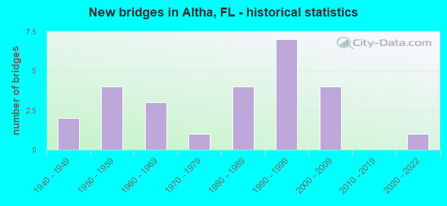
- New bridges - historical statistics
- 21940-1949
- 41950-1959
- 31960-1969
- 11970-1979
- 41980-1989
- 71990-1999
- 42000-2009
- 12020-2022


- Bridge Condition - Deck
- 12.5%Very good
- 50.0%Good
- 37.5%Satisfactory

- Bridge Condition - Superstructure
- 25.0%Very good
- 56.3%Good
- 18.8%Satisfactory

- Bridge Condition - Substructure
- 6.3%Excellent
- 18.8%Very good
- 50.0%Good
- 6.3%Satisfactory
- 12.5%Fair
- 6.3%Poor

- Bridge Condition - Channel
- 41.2%Good
- 17.6%Satisfactory
- 29.4%Fair
- 5.9%Poor
- 5.9%Critical

- Bridge Condition - Culverts
- 30.0%Good
- 20.0%Satisfactory
- 50.0%Fair
Find on map >> Show street view
Structure Number: 30238, Location: 1.2MI E OF EVERGLADES BL (Lat: 26.142028, Lng: -81.523111), Route carried "on" structure: State lands road , Year Built: 1990, Status: Open, Structure Length: 3.66m (12.01ft), Average Daily Traffic: 20 (year 2021), Truck Traffic: 50%, Average Future Daily Traffic: 24 (year 2041), Design Load: HS 20, Features Intersected: FAKA UNION CANAL, Facility Carried by Structure: 52ND AVE. SE
Minimum Vertical Clearance: 30+ m (98+ ft), Kilometerpoint: 0.000, Lanes on structure: 2, Owner: State Park, Forest, or Reservation Agency, Approaching Roadway Width: 5.5m (18.0ft), Material/Design: Prestressed concrete, Design/Construction: Slab, Number Of Spans In Main Unit: 3, Length of Maximum Span: 12.2m (40.0ft), Curb-To-Curb Width: 9.8m (32.2ft), Out-to-Out Width: 10.7m (35.1ft)
Condition: Deck: Good, Superstructure: Good, Substructure: Good, Channel: Good, Operating Rating: 57.2 metric tons, Method Used To Determine Operating Rating: Load Factor (LF), Inventory Rating: 34.3 metric tons, Method Used To Determine Inventory Rating: Load Factor (LF), Structural Evaluation: Better than present minimum criteria, Deck Geometry: Equal to present desirable criteria, Waterway Adequacy: Better than present minimum criteria, Approach Roadway Alignment: Equal to present desirable criteria, Designated Inspection Frequency: Every 24 months, Underwater Inspection Frequency: Every 24 months, Inspection Date: September 2021, Underwater Inspection Date: August 2021, Deck Structure Type: Concrete Precast Panels
Find on map >> Show street view
Structure Number: 30239, Location: 2.2MI E OF SR-29 (Lat: 26.155172, Lng: -81.310642), Route carried "on" structure: Interstate 75, Year Built: 1990, Status: Open, Structure Length: 3.66m (12.01ft), Average Daily Traffic: 11,500 (year 2021), Truck Traffic: 18%, Average Future Daily Traffic: 19,952 (year 2041), Design Load: HS 20+Mod, Features Intersected: WILDLIFE CROSSING NO.13
Minimum Vertical Clearance: 30+ m (98+ ft), Kilometerpoint: 43.533, Lanes on structure: 2, Base Highway Network: Yes, Toll: On Interstate toll segment, Owner: State Highway Agency, Approaching Roadway Width: 12.2m (40.0ft), Material/Design: Prestressed concrete, Design/Construction: Slab, Number Of Spans In Main Unit: 3, Length of Maximum Span: 12.2m (40.0ft), Curb-To-Curb Width: 12.2m (40.0ft), Out-to-Out Width: 13.1m (43.0ft)
Condition: Deck: Good, Superstructure: Good, Substructure: Very good, Operating Rating: 54.3 metric tons, Method Used To Determine Operating Rating: Load Factor (LF), Inventory Rating: 32.5 metric tons, Method Used To Determine Inventory Rating: Load Factor (LF), Structural Evaluation: Better than present minimum criteria, Deck Geometry: Better than present minimum criteria, Approach Roadway Alignment: Equal to present desirable criteria, Designated Inspection Frequency: Every 24 months, Inspection Date: May 2021, Deck Structure Type: Concrete Precast Panels, Wearing Surface/Protective System: Wearing Surface: Bituminous
Find on map >> Show street view
Structure Number: 70072, Location: 2.1MI E of JOEL BLVD (Lat: 26.709417, Lng: -81.566222), Route carried "on" structure: State highway 80, Year Built: 2003, Status: Open, Structure Length: 1.52m (4.99ft), Average Daily Traffic: 17,371 (year 2021), Truck Traffic: 13%, Average Future Daily Traffic: 30,139 (year 2041), Design Load: HS 20, Features Intersected: CARLOS WATERWAY
Minimum Vertical Clearance: 30+ m (98+ ft), Kilometerpoint: 0.053, Lanes on structure: 4, Base Highway Network: Yes, Owner: State Highway Agency, Approaching Roadway Width: 32.4m (106.3ft), Skew: 20 degrees, Material/Design: Concrete, Design/Construction: Culvert, Number Of Spans In Main Unit: 4, Length of Maximum Span: 3.7m (12.1ft)
Condition: Channel: Good, Culverts: Good, Operating Rating: 81.3 metric tons, Method Used To Determine Operating Rating: Load Factor (LF), Inventory Rating: 48.1 metric tons, Method Used To Determine Inventory Rating: Load Factor (LF), Structural Evaluation: Better than present minimum criteria, Waterway Adequacy: Equal to present desirable criteria, Approach Roadway Alignment: Equal to present desirable criteria, Designated Inspection Frequency: Every 24 months, Underwater Inspection Frequency: Every 24 months, Inspection Date: May 2021, Underwater Inspection Date: April 2021
Find on map >> Show street view
Structure Number: 1301, Location: 0.3 MI NORTH OF SR-64 (Lat: 27.502600, Lng: -82.481406), Route carried "on" structure: County highway , Year Built: 1980, Status: Open, Structure Length: 12.92m (42.39ft), Average Daily Traffic: 7,600 (year 2020), Truck Traffic: 9%, Average Future Daily Traffic: 13,186 (year 2042), Design Load: HS 20+Mod, Features Intersected: I-75 (SR-93), Facility Carried by Structure: KAY ROAD
Minimum Vertical Clearance: 30+ m (98+ ft), Kilometerpoint: 1.043, Lanes on structure: 2, Lanes under structure: 6, Owner: State Highway Agency, Approaching Roadway Width: 12.2m (40.0ft), Skew: 2 degrees, Material/Design: Prestressed concrete, Design/Construction: Stringer/Multi-beam, Number Of Spans In Main Unit: 5, Length of Maximum Span: 35.7m (117.1ft), Curb-To-Curb Width: 12.2m (40.0ft), Out-to-Out Width: 13.0m (42.7ft)
Condition: Deck: Good, Superstructure: Good, Substructure: Very good, Operating Rating: 61.7 metric tons, Method Used To Determine Operating Rating: Allowable Stress (AS), Inventory Rating: 48.1 metric tons, Method Used To Determine Inventory Rating: Allowable Stress (AS), Structural Evaluation: Better than present minimum criteria, Deck Geometry: Somewhat better than minimum adequacy, Underclear: Equal to present minimum criteria, Approach Roadway Alignment: Equal to present desirable criteria, Designated Inspection Frequency: Every 24 months, Inspection Date: November 2021, Deck Structure Type: Concrete Cast-file-Place
Find on map >> Show street view
Structure Number: 1341, Location: 1.2MI NORTH OF SR-70 (Lat: 27.390394, Lng: -82.219103), Route carried "on" structure: County highway , Year Built: 1989, Status: Posted for load, Structure Length: 1.23m (4.04ft), Average Daily Traffic: 30 (year 2020), Truck Traffic: 1%, Average Future Daily Traffic: 52 (year 2042), Design Load: HS 20, Features Intersected: OGLEBY CREEK, Facility Carried by Structure: OGLEBY CREEK RD.
Minimum Vertical Clearance: 30+ m (98+ ft), Kilometerpoint: 0.000, Lanes on structure: 1, Owner: County Highway Agency, Approaching Roadway Width: 4.1m (13.5ft), Material/Design: Wood or Timber, Design/Construction: Stringer/Multi-beam, Number Of Spans In Main Unit: 4, Length of Maximum Span: 3.5m (11.5ft), Curb-To-Curb Width: 3.4m (11.2ft), Out-to-Out Width: 3.6m (11.8ft)
Condition: Deck: Satisfactory, Superstructure: Good, Substructure: Good, Channel: Satisfactory, Operating Rating: 30.7 metric tons, Method Used To Determine Operating Rating: Allowable Stress (AS), Inventory Rating: 23.0 metric tons, Method Used To Determine Inventory Rating: Allowable Stress (AS), Structural Evaluation: Equal to present minimum criteria, Deck Geometry: High priority of corrective action, Waterway Adequacy: Better than present minimum criteria, Approach Roadway Alignment: Equal to present minimum criteria, Bridge Posting: Required (Relationship of Operating Rating to Maximum Legal Load: 30.0 - 39.9% below), Designated Inspection Frequency: Every 24 months, Other Special Inspection Frequency: Every 12 months, Inspection Date: March 2020, Other Special Inspection Date: March 2021, Deck Structure Type: Wood or Timber, Wearing Surface/Protective System: Wearing Surface: Wood or Timber
Find on map >> Show street view
Structure Number: 470008, Location: 0.7 Miles South of CR 274 (Lat: 30.567892, Lng: -85.070347), Route carried "on" structure: County highway 69A, Year Built: 1959, Status: Open, Structure Length: 0.95m (3.12ft), Average Daily Traffic: 550 (year 2019), Truck Traffic: 11%, Average Future Daily Traffic: 605 (year 2039), Features Intersected: Thomas Mill Creek
Minimum Vertical Clearance: 30+ m (98+ ft), Kilometerpoint: 8.946, Lanes on structure: 2, Owner: County Highway Agency, Approaching Roadway Width: 6.1m (20.0ft), Material/Design: Concrete, Design/Construction: Culvert, Number Of Spans In Main Unit: 3, Length of Maximum Span: 3.3m (10.8ft)
Condition: Channel: Fair, Culverts: Fair, Operating Rating: 74.4 metric tons, Method Used To Determine Operating Rating: Allowable Stress (AS), Inventory Rating: 44.5 metric tons, Method Used To Determine Inventory Rating: Allowable Stress (AS), Structural Evaluation: Somewhat better than minimum adequacy, Waterway Adequacy: Equal to present desirable criteria, Approach Roadway Alignment: Equal to present desirable criteria, Designated Inspection Frequency: Every 24 months, Underwater Inspection Frequency: Every 24 months, Inspection Date: August 2020, Underwater Inspection Date: August 2020
Find on map >> Show street view
Structure Number: 470032, Location: 0.34 Miles West of CR69A (Lat: 30.577828, Lng: -85.075572), Route carried "on" structure: County highway 274, Year Built: 1952, Status: Open, Structure Length: 0.95m (3.12ft), Average Daily Traffic: 1,000 (year 2019), Truck Traffic: 10%, Average Future Daily Traffic: 1,100 (year 2039), Design Load: H 20, Features Intersected: Thomas Mill Creek
Minimum Vertical Clearance: 30+ m (98+ ft), Kilometerpoint: 33.243, Lanes on structure: 2, Owner: County Highway Agency, Approaching Roadway Width: 9.1m (29.9ft), Material/Design: Concrete, Design/Construction: Culvert, Number Of Spans In Main Unit: 3, Length of Maximum Span: 3.2m (10.5ft)
Condition: Channel: Fair, Culverts: Fair, Operating Rating: 48.1 metric tons, Method Used To Determine Operating Rating: Allowable Stress (AS), Inventory Rating: 31.8 metric tons, Method Used To Determine Inventory Rating: Allowable Stress (AS), Structural Evaluation: Somewhat better than minimum adequacy, Waterway Adequacy: Equal to present desirable criteria, Approach Roadway Alignment: Equal to present desirable criteria, Designated Inspection Frequency: Every 24 months, Underwater Inspection Frequency: Every 24 months, Inspection Date: May 2020, Underwater Inspection Date: May 2020
Find on map >> Show street view
Structure Number: 470039, Location: 2.9 Miles West of SR71 (Lat: 30.545417, Lng: -85.159144), Route carried "on" structure: County highway 274, Year Built: 1960, Status: Open, Structure Length: 0.63m (2.07ft), Average Daily Traffic: 1,500 (year 2020), Truck Traffic: 12%, Average Future Daily Traffic: 1,650 (year 2040), Features Intersected: Holliman Branch
Minimum Vertical Clearance: 30+ m (98+ ft), Kilometerpoint: 23.086, Lanes on structure: 2, Owner: County Highway Agency, Approaching Roadway Width: 9.8m (32.2ft), Material/Design: Concrete, Design/Construction: Culvert, Number Of Spans In Main Unit: 2, Length of Maximum Span: 3.2m (10.5ft)
Condition: Channel: Satisfactory, Culverts: Fair, Operating Rating: 60.8 metric tons, Method Used To Determine Operating Rating: Allowable Stress (AS), Inventory Rating: 41.7 metric tons, Method Used To Determine Inventory Rating: Allowable Stress (AS), Structural Evaluation: Somewhat better than minimum adequacy, Waterway Adequacy: Better than present minimum criteria, Approach Roadway Alignment: Equal to present desirable criteria, Designated Inspection Frequency: Every 24 months, Underwater Inspection Frequency: Every 24 months, Inspection Date: May 2021, Underwater Inspection Date: May 2021
Find on map >> Show street view
Structure Number: 47004, Location: 2.3 West of SR71 (Lat: 30.554892, Lng: -85.156953), Route carried "on" structure: County highway 274, Year Built: 1960, Status: Open, Structure Length: 0.63m (2.07ft), Average Daily Traffic: 1,500 (year 2020), Truck Traffic: 12%, Average Future Daily Traffic: 1,650 (year 2040), Features Intersected: Hollis Branch
Minimum Vertical Clearance: 30+ m (98+ ft), Kilometerpoint: 24.156, Lanes on structure: 2, Owner: County Highway Agency, Approaching Roadway Width: 9.8m (32.2ft), Material/Design: Concrete, Design/Construction: Culvert, Number Of Spans In Main Unit: 2, Length of Maximum Span: 3.2m (10.5ft)
Condition: Channel: Fair, Culverts: Fair, Operating Rating: 61.7 metric tons, Method Used To Determine Operating Rating: Allowable Stress (AS), Inventory Rating: 41.7 metric tons, Method Used To Determine Inventory Rating: Allowable Stress (AS), Structural Evaluation: Somewhat better than minimum adequacy, Waterway Adequacy: Somewhat better than minimum adequacy, Approach Roadway Alignment: Equal to present desirable criteria, Designated Inspection Frequency: Every 24 months, Underwater Inspection Frequency: Every 24 months, Inspection Date: May 2021, Underwater Inspection Date: May 2021
Find on map >> Show street view
Structure Number: 470041, Location: 1.7 Miles South of CR 274 (Lat: 30.554778, Lng: -85.064417), Route carried "on" structure: County highway 69A, Year Built: 1959, Status: Open, Structure Length: 0.63m (2.07ft), Average Daily Traffic: 550 (year 2020), Truck Traffic: 11%, Average Future Daily Traffic: 605 (year 2040), Design Load: H 20, Features Intersected: Graves Creek
Minimum Vertical Clearance: 30+ m (98+ ft), Kilometerpoint: 7.268, Lanes on structure: 2, Owner: County Highway Agency, Approaching Roadway Width: 6.1m (20.0ft), Material/Design: Concrete, Design/Construction: Culvert, Number Of Spans In Main Unit: 2, Length of Maximum Span: 3.2m (10.5ft)
Condition: Channel: Poor, Culverts: Fair, Operating Rating: 59.0 metric tons, Method Used To Determine Operating Rating: Allowable Stress (AS), Inventory Rating: 39.0 metric tons, Method Used To Determine Inventory Rating: Allowable Stress (AS), Structural Evaluation: Somewhat better than minimum adequacy, Waterway Adequacy: Better than present minimum criteria, Approach Roadway Alignment: Equal to present desirable criteria, Designated Inspection Frequency: Every 24 months, Other Special Inspection Frequency: Every 12 months, Inspection Date: June 2020, Other Special Inspection Date: June 2021
Find on map >> Show street view
Structure Number: 474057, Location: 3.8 Miles West of SR 71 (Lat: 30.534550, Lng: -85.165181), Route carried "on" structure: County highway 274, Year Built: 1997, Status: Open, Structure Length: 5.05m (16.57ft), Average Daily Traffic: 1,700 (year 2019), Truck Traffic: 10%, Average Future Daily Traffic: 1,870 (year 2039), Features Intersected: Chipola River
Minimum Vertical Clearance: 30+ m (98+ ft), Kilometerpoint: 21.668, Lanes on structure: 2, Owner: County Highway Agency, Approaching Roadway Width: 9.6m (31.5ft), Material/Design: Concrete continuous, Design/Construction: Arch - Deck, Number Of Spans In Main Unit: 1, Number Of Approach Spans: 2, Length of Maximum Span: 41.0m (134.5ft), Curb-To-Curb Width: 9.6m (31.5ft), Out-to-Out Width: 10.4m (34.1ft)
Condition: Deck: Satisfactory, Superstructure: Good, Substructure: Fair, Channel: Good, Operating Rating: 41.7 metric tons, Method Used To Determine Operating Rating: Load Factor (LF), Inventory Rating: 24.5 metric tons, Method Used To Determine Inventory Rating: Load Factor (LF), Structural Evaluation: Somewhat better than minimum adequacy, Deck Geometry: Somewhat better than minimum adequacy, Waterway Adequacy: Equal to present desirable criteria, Approach Roadway Alignment: Equal to present desirable criteria, Designated Inspection Frequency: Every 24 months, Underwater Inspection Frequency: Every 24 months, Inspection Date: April 2021, Underwater Inspection Date: April 2021, Deck Structure Type: Concrete Cast-file-Place
Find on map >> Show street view
Structure Number: 530026, Location: 0.96 Miles East of SR 73 (Lat: 30.627581, Lng: -85.165500), Route carried "on" structure: County highway 278, Year Built: 1966, Status: Open, Structure Length: 10.65m (34.94ft), Average Daily Traffic: 1,600 (year 2020), Truck Traffic: 16%, Average Future Daily Traffic: 1,760 (year 2040), Design Load: H 20, Features Intersected: Chipola River
Minimum Vertical Clearance: 30+ m (98+ ft), Kilometerpoint: 1.516, Lanes on structure: 2, Owner: County Highway Agency, Approaching Roadway Width: 6.4m (21.0ft), Material/Design: Prestressed concrete, Design/Construction: Stringer/Multi-beam, Number Of Spans In Main Unit: 8, Length of Maximum Span: 13.3m (43.6ft), Curb or Sidewalk Widths: Left: 0.4m (1.3ft), Right: 0.4m (1.3ft), Curb-To-Curb Width: 7.3m (24.0ft), Out-to-Out Width: 8.9m (29.2ft)
Condition: Deck: Satisfactory, Superstructure: Satisfactory, Substructure: Poor, Channel: Critical, Operating Rating: 64.4 metric tons, Method Used To Determine Operating Rating: Load Factor (LF), Inventory Rating: 39.9 metric tons, Method Used To Determine Inventory Rating: Load Factor (LF), Structural Evaluation: Meets minimum limits, Deck Geometry: Meets minimum limits, Waterway Adequacy: Equal to present desirable criteria, Approach Roadway Alignment: Equal to present desirable criteria, Designated Inspection Frequency: Every 24 months, Underwater Inspection Frequency: Every 3 months, Other Special Inspection Frequency: Every 3 months, Inspection Date: January 2021, Underwater Inspection Date: January 2022, Other Special Inspection Date: January 2022, Deck Structure Type: Concrete Cast-file-Place
Find on map >> Show street view
Structure Number: 530033, Location: 1.0Mi N of Calhoun Co Ln (Lat: 30.579722, Lng: -85.182639), Route carried "on" structure: State highway 73, Year Built: 1942, Year Reconstructed: 1999, Status: Open, Structure Length: 0.96m (3.15ft), Average Daily Traffic: 1,900 (year 2020), Truck Traffic: 18%, Average Future Daily Traffic: 3,296 (year 2042), Design Load: H 15, Features Intersected: Pumpkin Creek
Minimum Vertical Clearance: 30+ m (98+ ft), Kilometerpoint: 1.711, Lanes on structure: 2, Owner: State Highway Agency, Approaching Roadway Width: 10.4m (34.1ft), Material/Design: Concrete, Design/Construction: Culvert, Number Of Spans In Main Unit: 3, Length of Maximum Span: 3.0m (9.8ft)
Condition: Channel: Good, Culverts: Satisfactory, Operating Rating: 58.1 metric tons, Method Used To Determine Operating Rating: Load Factor (LF), Inventory Rating: 34.5 metric tons, Method Used To Determine Inventory Rating: Load Factor (LF), Structural Evaluation: Equal to present minimum criteria, Waterway Adequacy: Equal to present desirable criteria, Approach Roadway Alignment: Equal to present desirable criteria, Designated Inspection Frequency: Every 24 months, Underwater Inspection Frequency: Every 24 months, Inspection Date: March 2020, Underwater Inspection Date: March 2020
Find on map >> Show street view
Structure Number: 530034, Location: 3.4MI N of Calhoun Co Ln (Lat: 30.614500, Lng: -85.180861), Route carried "on" structure: State highway 73, Year Built: 1942, Year Reconstructed: 1999, Status: Open, Structure Length: 0.95m (3.12ft), Average Daily Traffic: 1,900 (year 2020), Truck Traffic: 18%, Average Future Daily Traffic: 3,296 (year 2042), Design Load: H 15, Features Intersected: Branch
Minimum Vertical Clearance: 30+ m (98+ ft), Kilometerpoint: 5.584, Lanes on structure: 2, Owner: State Highway Agency, Approaching Roadway Width: 10.4m (34.1ft), Material/Design: Concrete, Design/Construction: Culvert, Number Of Spans In Main Unit: 3, Length of Maximum Span: 3.0m (9.8ft)
Condition: Channel: Good, Culverts: Good, Operating Rating: 54.4 metric tons, Method Used To Determine Operating Rating: Load Factor (LF), Inventory Rating: 32.7 metric tons, Method Used To Determine Inventory Rating: Load Factor (LF), Structural Evaluation: Better than present minimum criteria, Waterway Adequacy: Equal to present desirable criteria, Approach Roadway Alignment: Equal to present desirable criteria, Designated Inspection Frequency: Every 24 months, Underwater Inspection Frequency: Every 24 months, Inspection Date: March 2020, Underwater Inspection Date: March 2020
Find on map >> Show street view
Structure Number: 53008, Location: 1.2 Mi. N of County Line (Lat: 30.625047, Lng: -85.153075), Route carried "on" structure: State highway 71, Year Built: 1978, Status: Open, Structure Length: 3.96m (12.99ft), Average Daily Traffic: 4,400 (year 2020), Truck Traffic: 10%, Average Future Daily Traffic: 7,634 (year 2042), Design Load: HS 20, Features Intersected: Sink Creek
Minimum Vertical Clearance: 30+ m (98+ ft), Kilometerpoint: 2.031, Lanes on structure: 2, Owner: State Highway Agency, Approaching Roadway Width: 10.4m (34.1ft), Material/Design: Prestressed concrete, Design/Construction: Slab, Number Of Spans In Main Unit: 4, Length of Maximum Span: 9.9m (32.5ft), Curb-To-Curb Width: 12.2m (40.0ft), Out-to-Out Width: 13.1m (43.0ft)
Condition: Deck: Good, Superstructure: Good, Substructure: Good, Channel: Satisfactory, Operating Rating: 42.1 metric tons, Method Used To Determine Operating Rating: Load and Resistance Factor (LRFR), Inventory Rating: 35.3 metric tons, Method Used To Determine Inventory Rating: Load and Resistance Factor (LRFR), Structural Evaluation: Better than present minimum criteria, Deck Geometry: Equal to present minimum criteria, Waterway Adequacy: Equal to present desirable criteria, Approach Roadway Alignment: Equal to present desirable criteria, Designated Inspection Frequency: Every 24 months, Inspection Date: May 2021, Deck Structure Type: Concrete Precast Panels, Wearing Surface/Protective System: Wearing Surface: Bituminous
Find on map >> Show street view
Structure Number: 530166, Location: 0.25Mi N of Calhoun Co Ln (Lat: 30.568333, Lng: -85.183333), Route carried "on" structure: State highway 73, Year Built: 1998, Status: Open, Structure Length: 1.43m (4.69ft), Average Daily Traffic: 1,900 (year 2020), Truck Traffic: 18%, Average Future Daily Traffic: 3,296 (year 2042), Design Load: HS 20, Features Intersected: Mill Creek
Minimum Vertical Clearance: 30+ m (98+ ft), Kilometerpoint: 0.398, Lanes on structure: 2, Owner: State Highway Agency, Approaching Roadway Width: 10.4m (34.1ft), Material/Design: Concrete, Design/Construction: Culvert, Number Of Spans In Main Unit: 4, Length of Maximum Span: 3.0m (9.8ft)
Condition: Channel: Good, Culverts: Good, Operating Rating: 68.0 metric tons, Method Used To Determine Operating Rating: Load Factor (LF), Inventory Rating: 40.8 metric tons, Method Used To Determine Inventory Rating: Load Factor (LF), Structural Evaluation: Better than present minimum criteria, Waterway Adequacy: Equal to present desirable criteria, Approach Roadway Alignment: Equal to present desirable criteria, Designated Inspection Frequency: Every 24 months, Inspection Date: March 2020
Find on map >> Show street view
Structure Number: 720033, Location: SR-115 OVER TROUT RIVER (Lat: 30.417794, Lng: -81.696781), Route carried "on" structure: State highway 115, Year Built: 1957, Status: Open, Structure Length: 22.62m (74.21ft), Average Daily Traffic: 26,000 (year 2020), Truck Traffic: 3%, Average Future Daily Traffic: 45,110 (year 2042), Design Load: H 20, Features Intersected: TROUT RIVER
Minimum Vertical Clearance: 30+ m (98+ ft), Kilometerpoint: 7.796, Lanes on structure: 4, Owner: State Highway Agency, Approaching Roadway Width: 19.3m (63.3ft), Skew: 9 degrees, Navigation Control: Yes ( Vertical Clearance: 5.5m (18.0ft), Horizontal Clearance: 12.2m (40.0ft)), Material/Design: Concrete, Design/Construction: Tee Beam, Number Of Spans In Main Unit: 20, Length of Maximum Span: 14.9m (48.9ft), Curb or Sidewalk Widths: Left: 1.1m (3.6ft), Right: 1.1m (3.6ft), Curb-To-Curb Width: 14.6m (47.9ft), Out-to-Out Width: 17.2m (56.4ft)
Condition: Deck: Satisfactory, Superstructure: Satisfactory, Substructure: Fair, Channel: Fair, Operating Rating: 60.8 metric tons, Method Used To Determine Operating Rating: Load Factor (LF), Inventory Rating: 36.3 metric tons, Method Used To Determine Inventory Rating: Load Factor (LF), Structural Evaluation: Somewhat better than minimum adequacy, Deck Geometry: High priority of replacement, Waterway Adequacy: Equal to present desirable criteria, Approach Roadway Alignment: Equal to present desirable criteria, Length Of Structure Improvement: 22.62m (74.21ft), Designated Inspection Frequency: Every 24 months, Underwater Inspection Frequency: Every 23 months, Inspection Date: October 2020, Underwater Inspection Date: October 2020, Bridge Improvement Cost: $2,000,000, Roadway Improvement Cost: $124,000, Total Project Cost: $2,124,000 ( Estimate for 2015), Deck Structure Type: Concrete Cast-file-Place
Find on map >> Show street view
Structure Number: 770033, Location: SR-46 over SCLRR (Lat: 28.811194, Lng: -81.294575), Route carried "on" structure: State highway 46, Year Built: 1984, Status: Open, Structure Length: 8.12m (26.64ft), Average Daily Traffic: 18,600 (year 2020), Truck Traffic: 13%, Average Future Daily Traffic: 32,271 (year 2042), Design Load: HS 20, Features Intersected: SCLRR
Minimum Vertical Clearance: 30+ m (98+ ft), Kilometerpoint: 12.221, Lanes on structure: 4, Owner: State Highway Agency, Approaching Roadway Width: 22.5m (73.8ft), Skew: 25 degrees, Material/Design: Prestressed concrete, Design/Construction: Stringer/Multi-beam, Number Of Spans In Main Unit: 3, Length of Maximum Span: 39.9m (130.9ft), Curb-To-Curb Width: 26.6m (87.3ft), Out-to-Out Width: 27.5m (90.2ft)
Condition: Deck: Satisfactory, Superstructure: Good, Substructure: Good, Operating Rating: 71.7 metric tons, Method Used To Determine Operating Rating: Load Factor (LF), Inventory Rating: 43.0 metric tons, Method Used To Determine Inventory Rating: Load Factor (LF), Structural Evaluation: Better than present minimum criteria, Deck Geometry: Superior to present desirable criteria, Underclear: Better than present minimum criteria, Approach Roadway Alignment: Equal to present desirable criteria, Designated Inspection Frequency: Every 24 months, Inspection Date: January 2022, Deck Structure Type: Concrete Cast-file-Place, Wearing Surface/Protective System: Wearing Surface: Monolithic Concrete
Find on map >> Show street view
Structure Number: 770036, Location: .81MI. E of SR 600 (Lat: 28.718928, Lng: -81.308753), Route carried "on" structure: State highway 419, Year Built: 1986, Status: Open, Structure Length: 1.13m (3.71ft), Average Daily Traffic: 16,700 (year 2020), Truck Traffic: 19%, Average Future Daily Traffic: 28,974 (year 2042), Design Load: HS 20, Features Intersected: Soldier Creek
Minimum Vertical Clearance: 30+ m (98+ ft), Kilometerpoint: 1.304, Lanes on structure: 2, Owner: State Highway Agency, Approaching Roadway Width: 9.7m (31.8ft), Skew: 2 degrees, Material/Design: Concrete, Design/Construction: Culvert, Number Of Spans In Main Unit: 3, Length of Maximum Span: 3.7m (12.1ft)
Condition: Channel: Fair, Culverts: Satisfactory, Operating Rating: 77.8 metric tons, Method Used To Determine Operating Rating: Load Factor (LF), Inventory Rating: 46.7 metric tons, Method Used To Determine Inventory Rating: Load Factor (LF), Structural Evaluation: Equal to present minimum criteria, Waterway Adequacy: Better than present minimum criteria, Approach Roadway Alignment: Equal to present desirable criteria, Designated Inspection Frequency: Every 24 months, Inspection Date: January 2022
Find on map >> Show street view
Structure Number: 770039, Location: Lake Mary Blvd WB - I-4 (Lat: 28.756331, Lng: -81.363283), Route carried "on" structure: County highway , Year Built: 1992, Status: Open, Structure Length: 6.98m (22.90ft), Average Daily Traffic: 9,800 (year 2020), Truck Traffic: 4%, Average Future Daily Traffic: 17,003 (year 2042), Design Load: HS 20+Mod, Features Intersected: I-4, Facility Carried by Structure: Lake Mary Blvd WB
Minimum Vertical Clearance: 30+ m (98+ ft), Kilometerpoint: 1.815, Lanes on structure: 5, Lanes under structure: 9, Owner: State Highway Agency, Approaching Roadway Width: 27.6m (90.6ft), Skew: 21 degrees, Material/Design: Prestressed concrete, Design/Construction: Stringer/Multi-beam, Number Of Spans In Main Unit: 2, Length of Maximum Span: 36.6m (120.1ft), Curb-To-Curb Width: 31.2m (102.4ft), Out-to-Out Width: 31.9m (104.7ft)
Condition: Deck: Good, Superstructure: Good, Substructure: Good, Operating Rating: 82.4 metric tons, Method Used To Determine Operating Rating: Load Factor (LF), Inventory Rating: 49.4 metric tons, Method Used To Determine Inventory Rating: Load Factor (LF), Structural Evaluation: Better than present minimum criteria, Deck Geometry: Superior to present desirable criteria, Underclear: Somewhat better than minimum adequacy, Approach Roadway Alignment: Equal to present desirable criteria, Designated Inspection Frequency: Every 24 months, Inspection Date: October 2020, Deck Structure Type: Concrete Cast-file-Place, Wearing Surface/Protective System: Wearing Surface: Monolithic Concrete
Find on map >> Show street view
Structure Number: 770042, Location: 0.3 MI SOUTH OF CR 427 (Lat: 28.751972, Lng: -81.266506), Route carried "on" structure: State highway 417, Year Built: 1993, Status: Open, Structure Length: 1.97m (6.46ft), Average Daily Traffic: 27,400 (year 2020), Truck Traffic: 12%, Average Future Daily Traffic: 47,539 (year 2042), Design Load: H 20, Features Intersected: CSX RAILROAD
Minimum Vertical Clearance: 30+ m (98+ ft), Kilometerpoint: 17.658, Lanes on structure: 2, Base Highway Network: Yes, Toll: On toll road, Owner: State Toll Authority, Approaching Roadway Width: 11.6m (38.1ft), Skew: 3 degrees, Material/Design: Prestressed concrete, Design/Construction: Stringer/Multi-beam, Number Of Spans In Main Unit: 1, Length of Maximum Span: 19.7m (64.6ft), Curb-To-Curb Width: 12.2m (40.0ft), Out-to-Out Width: 13.1m (43.0ft)
Condition: Deck: Good, Superstructure: Good, Substructure: Good, Operating Rating: 43.0 metric tons, Method Used To Determine Operating Rating: Load and Resistance Factor (LRFR), Inventory Rating: 33.2 metric tons, Method Used To Determine Inventory Rating: Load and Resistance Factor (LRFR), Structural Evaluation: Better than present minimum criteria, Deck Geometry: Better than present minimum criteria, Underclear: Superior to present desirable criteria, Approach Roadway Alignment: Equal to present desirable criteria, Designated Inspection Frequency: Every 24 months, Inspection Date: January 2022, Deck Structure Type: Concrete Cast-file-Place
Find on map >> Show street view
Structure Number: 770055, Location: 0.83 MI NORTH OF SR 434 (Lat: 28.710714, Lng: -81.238247), Route carried "on" structure: State highway 417, Year Built: 1993, Status: Open, Structure Length: 241.86m (793.50ft), Average Daily Traffic: 27,400 (year 2020), Truck Traffic: 12%, Average Future Daily Traffic: 47,539 (year 2042), Design Load: HS 20+Mod, Features Intersected: LAKE JESUP
Minimum Vertical Clearance: 30+ m (98+ ft), Kilometerpoint: 11.108, Lanes on structure: 2, Base Highway Network: Yes, Toll: On toll road, Owner: State Toll Authority, Approaching Roadway Width: 12.2m (40.0ft), Material/Design: Prestressed concrete, Design/Construction: Stringer/Multi-beam, Number Of Spans In Main Unit: 90, Length of Maximum Span: 26.9m (88.3ft), Curb-To-Curb Width: 12.2m (40.0ft), Out-to-Out Width: 13.1m (43.0ft)
Condition: Deck: Satisfactory, Superstructure: Satisfactory, Substructure: Satisfactory, Channel: Good, Operating Rating: 54.0 metric tons, Method Used To Determine Operating Rating: Load and Resistance Factor (LRFR), Inventory Rating: 41.6 metric tons, Method Used To Determine Inventory Rating: Load and Resistance Factor (LRFR), Structural Evaluation: Equal to present minimum criteria, Deck Geometry: Better than present minimum criteria, Waterway Adequacy: Superior to present desirable criteria, Approach Roadway Alignment: Equal to present desirable criteria, Designated Inspection Frequency: Every 24 months, Underwater Inspection Frequency: Every 24 months, Inspection Date: January 2022, Underwater Inspection Date: January 2022, Deck Structure Type: Concrete Cast-file-Place
Find on map >> Show street view
Structure Number: 770098, Location: Osprey Hammock Trail (Lat: 28.814889, Lng: -81.413083), Route carried "on" structure: State highway 429, Year Built: 2021, Status: Not yet open, Structure Length: 10.36m (33.99ft), Average Daily Traffic: 1,500 (year 2020), Truck Traffic: 10%, Average Future Daily Traffic: 3,000 (year 2042), Design Load: HL 93, Features Intersected: Osprey Hammock Trail
Minimum Vertical Clearance: 30+ m (98+ ft), Kilometerpoint: 0.000, Lanes on structure: 3, Lanes under structure: 2, Toll: Toll bridge, Owner: State Toll Authority, Approaching Roadway Width: 15.8m (51.8ft), Material/Design: Prestressed concrete, Design/Construction: Stringer/Multi-beam, Number Of Spans In Main Unit: 2, Length of Maximum Span: 51.8m (169.9ft), Curb-To-Curb Width: 15.8m (51.8ft), Out-to-Out Width: 16.7m (54.8ft)
Condition: Deck: Very good, Superstructure: Very good, Substructure: Excellent, Operating Rating: 68.6 metric tons, Method Used To Determine Operating Rating: Load and Resistance Factor (LRFR), Inventory Rating: 49.6 metric tons, Method Used To Determine Inventory Rating: Load and Resistance Factor (LRFR), Structural Evaluation: Equal to present desirable criteria, Deck Geometry: Somewhat better than minimum adequacy, Underclear: Superior to present desirable criteria, Approach Roadway Alignment: Equal to present desirable criteria, Designated Inspection Frequency: Every 24 months, Inspection Date: January 2022, Deck Structure Type: Concrete Cast-file-Place, Wearing Surface/Protective System: Wearing Surface: Monolithic Concrete
Find on map >> Show street view
Structure Number: 770603, Location: 1.2MI NORTH OF CR 427 (Lat: 28.771331, Lng: -81.279756), Route carried "on" structure: State highway 417, Year Built: 2002, Status: Open, Structure Length: 4.69m (15.39ft), Average Daily Traffic: 23,050 (year 2020), Truck Traffic: 12%, Average Future Daily Traffic: 39,992 (year 2042), Design Load: HS 20+Mod, Features Intersected: US 17 92
Minimum Vertical Clearance: 30+ m (98+ ft), Kilometerpoint: 20.271, Lanes on structure: 3, Lanes under structure: 4, Base Highway Network: Yes, Toll: On toll road, Owner: State Toll Authority, Approaching Roadway Width: 16.2m (53.1ft), Skew: 1 degrees, Material/Design: Steel, Design/Construction: Stringer/Multi-beam, Number Of Spans In Main Unit: 1, Length of Maximum Span: 46.9m (153.9ft), Curb-To-Curb Width: 17.4m (57.1ft), Out-to-Out Width: 18.3m (60.0ft)
Condition: Deck: Good, Superstructure: Very good, Substructure: Good, Operating Rating: 55.9 metric tons, Method Used To Determine Operating Rating: Load Factor (LF), Inventory Rating: 33.3 metric tons, Method Used To Determine Inventory Rating: Load Factor (LF), Structural Evaluation: Better than present minimum criteria, Deck Geometry: Better than present minimum criteria, Underclear: Better than present minimum criteria, Approach Roadway Alignment: Equal to present desirable criteria, Designated Inspection Frequency: Every 24 months, Inspection Date: Febuary 2022, Deck Structure Type: Concrete Cast-file-Place
Find on map >> Show street view
Structure Number: 770606, Location: 2.1 MI NORTH OF CR 427 (Lat: 28.774506, Lng: -81.293492), Route carried "on" structure: State highway 417, Year Built: 2002, Status: Open, Structure Length: 2.40m (7.87ft), Average Daily Traffic: 22,875 (year 2020), Truck Traffic: 12%, Average Future Daily Traffic: 39,688 (year 2042), Design Load: HS 20+Mod, Features Intersected: LIVE OAK BLVD
Minimum Vertical Clearance: 30.45m (99.90ft), Kilometerpoint: 21.686, Lanes on structure: 2, Lanes under structure: 2, Base Highway Network: Yes, Toll: On toll road, Owner: State Toll Authority, Approaching Roadway Width: 12.2m (40.0ft), Skew: 1 degrees, Material/Design: Prestressed concrete, Design/Construction: Stringer/Multi-beam, Number Of Spans In Main Unit: 1, Length of Maximum Span: 24.0m (78.7ft), Curb-To-Curb Width: 12.2m (40.0ft), Out-to-Out Width: 13.1m (43.0ft)
Condition: Deck: Good, Superstructure: Very good, Substructure: Very good, Operating Rating: 54.9 metric tons, Method Used To Determine Operating Rating: Load Factor (LF), Inventory Rating: 32.9 metric tons, Method Used To Determine Inventory Rating: Load Factor (LF), Structural Evaluation: Equal to present desirable criteria, Deck Geometry: Better than present minimum criteria, Underclear: Superior to present desirable criteria, Approach Roadway Alignment: Equal to present desirable criteria, Designated Inspection Frequency: Every 24 months, Inspection Date: January 2022, Deck Structure Type: Concrete Cast-file-Place
Find on map >> Show street view
Structure Number: 770615, Location: 0.9 MI EAST OF I-4 (Lat: 28.798056, Lng: -81.331819), Route carried "on" structure: State highway 417, Year Built: 2002, Status: Open, Structure Length: 7.54m (24.74ft), Average Daily Traffic: 21,700 (year 2020), Truck Traffic: 12%, Average Future Daily Traffic: 37,650 (year 2042), Design Load: HS 20, Features Intersected: CR 431B (RINEHART RD)
Minimum Vertical Clearance: 30+ m (98+ ft), Kilometerpoint: 27.328, Lanes on structure: 3, Lanes under structure: 6, Base Highway Network: Yes, Toll: On toll road, Owner: State Toll Authority, Approaching Roadway Width: 14.6m (47.9ft), Skew: 4 degrees, Material/Design: Steel, Design/Construction: Stringer/Multi-beam, Number Of Spans In Main Unit: 1, Length of Maximum Span: 75.4m (247.4ft), Curb-To-Curb Width: 15.6m (51.2ft), Out-to-Out Width: 16.5m (54.1ft)
Condition: Deck: Very good, Superstructure: Very good, Substructure: Good, Operating Rating: 55.2 metric tons, Method Used To Determine Operating Rating: Load Factor (LF), Inventory Rating: 33.0 metric tons, Method Used To Determine Inventory Rating: Load Factor (LF), Structural Evaluation: Better than present minimum criteria, Deck Geometry: Somewhat better than minimum adequacy, Underclear: Superior to present desirable criteria, Approach Roadway Alignment: Equal to present desirable criteria, Designated Inspection Frequency: Every 24 months, Inspection Date: January 2022, Deck Structure Type: Concrete Cast-file-Place