Bridge Statistics for Altamonte Springs, Florida (FL)
Condition, Traffic, Stress, Structural Evaluation, Project Costs
- National Bridge Inventory (NBI) Statistics
- 26Number of bridges
- 344ft / 105mTotal length
- $270,000Total costs
- 1,196,424Total average daily traffic
- 65,685Total average daily truck traffic
- National Bridge Inventory (NBI) Registered Bridges for Altamonte Springs
- No street view available for this location
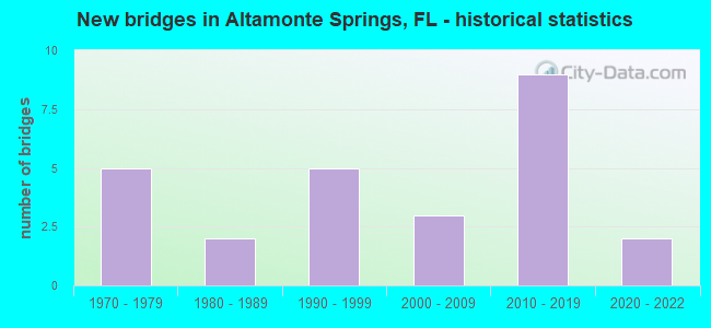
- New bridges - historical statistics
- 51970-1979
- 21980-1989
- 51990-1999
- 32000-2009
- 92010-2019
- 22020-2022

- Reconstructed bridges - Historical Statistics
- 11990-1999
- 12000-2009
- 12010-2019


- Bridge Condition - Deck
- 29.4%Very good
- 58.8%Good
- 5.9%Satisfactory
- 5.9%Fair

- Bridge Condition - Superstructure
- 47.1%Very good
- 47.1%Good
- 5.9%Satisfactory

- Bridge Condition - Substructure
- 35.3%Very good
- 52.9%Good
- 11.8%Satisfactory

- Bridge Condition - Channel
- 7.1%Very good
- 71.4%Good
- 21.4%Satisfactory

- Bridge Condition - Culverts
- 66.7%Good
- 33.3%Satisfactory
Find on map >> Show street view
Structure Number: 750896, Location: WB 0.7MI W OF I-4 (Lat: 28.632528, Lng: -81.398917), Route carried "on" structure: State highway 414, Year Built: 2017, Status: Open, Structure Length: 17.34m (56.89ft), Average Daily Traffic: 83,200 (year 2020), Truck Traffic: 8%, Average Future Daily Traffic: 92,700 (year 2040), Design Load: HL 93, Features Intersected: Keller Road
Minimum Vertical Clearance: 30.18m (99.02ft), Kilometerpoint: 63.722, Lanes on structure: 3, Lanes under structure: 7, Base Highway Network: Yes, Owner: State Highway Agency, Approaching Roadway Width: 18.3m (60.0ft), Skew: 9 degrees, Material/Design: Steel continuous, Design/Construction: Stringer/Multi-beam, Number Of Spans In Main Unit: 3, Length of Maximum Span: 83.5m (274.0ft), Curb-To-Curb Width: 18.3m (60.0ft), Out-to-Out Width: 19.2m (63.0ft)
Condition: Deck: Very good, Superstructure: Very good, Substructure: Very good, Operating Rating: 44.7 metric tons, Method Used To Determine Operating Rating: Load and Resistance Factor (LRFR), Inventory Rating: 34.3 metric tons, Method Used To Determine Inventory Rating: Load and Resistance Factor (LRFR), Structural Evaluation: Equal to present desirable criteria, Deck Geometry: Superior to present desirable criteria, Underclear: Equal to present minimum criteria, Approach Roadway Alignment: Equal to present desirable criteria, Designated Inspection Frequency: Every 24 months, Inspection Date: October 2020, Deck Structure Type: Concrete Cast-file-Place
Find on map >> Show street view
Structure Number: 750938, Location: 0.7MI W/O I-4 (Lat: 28.632111, Lng: -81.398611), Route carried "on" structure: State highway 414, Year Built: 2020, Status: Open, Structure Length: 16.92m (55.51ft), Average Daily Traffic: 41,600 (year 2022), Truck Traffic: 8%, Average Future Daily Traffic: 49,920 (year 2042), Design Load: HL 93, Features Intersected: Keller Rd
Minimum Vertical Clearance: 30.45m (99.90ft), Kilometerpoint: 63.714, Lanes on structure: 3, Lanes under structure: 6, Base Highway Network: Yes, Owner: State Highway Agency, Approaching Roadway Width: 18.3m (60.0ft), Skew: 9 degrees, Material/Design: Steel continuous, Design/Construction: Stringer/Multi-beam, Number Of Spans In Main Unit: 3, Length of Maximum Span: 79.2m (259.8ft), Curb-To-Curb Width: 18.3m (60.0ft), Out-to-Out Width: 19.2m (63.0ft)
Condition: Deck: Very good, Superstructure: Very good, Substructure: Very good, Operating Rating: 46.7 metric tons, Method Used To Determine Operating Rating: Load and Resistance Factor (LRFR), Inventory Rating: 35.9 metric tons, Method Used To Determine Inventory Rating: Load and Resistance Factor (LRFR), Structural Evaluation: Equal to present desirable criteria, Deck Geometry: Superior to present desirable criteria, Underclear: Better than present minimum criteria, Approach Roadway Alignment: Equal to present desirable criteria, Designated Inspection Frequency: Every 24 months, Inspection Date: January 2022, Deck Structure Type: Concrete Cast-file-Place
Find on map >> Show street view
Structure Number: 77003, Location: SR-434 -Little Wekiva R. (Lat: 28.686853, Lng: -81.397061), Route carried "on" structure: State highway 434, Year Built: 1977, Year Reconstructed: 2010, Status: Open, Structure Length: 4.05m (13.29ft), Average Daily Traffic: 63,000 (year 2020), Truck Traffic: 6%, Average Future Daily Traffic: 109,305 (year 2042), Design Load: HS 20, Features Intersected: Little Wekiva River
Minimum Vertical Clearance: 30+ m (98+ ft), Kilometerpoint: 7.345, Lanes on structure: 7, Base Highway Network: Yes, Owner: State Highway Agency, Approaching Roadway Width: 29.9m (98.1ft), Skew: 4 degrees, Material/Design: Prestressed concrete, Design/Construction: Stringer/Multi-beam, Number Of Spans In Main Unit: 3, Length of Maximum Span: 14.3m (46.9ft), Curb or Sidewalk Widths: Left: 1.8m (5.9ft), Right: 1.8m (5.9ft), Curb-To-Curb Width: 29.9m (98.1ft), Out-to-Out Width: 35.4m (116.1ft)
Condition: Deck: Fair, Superstructure: Good, Substructure: Good, Channel: Good, Operating Rating: 51.3 metric tons, Method Used To Determine Operating Rating: Load Factor (LF), Inventory Rating: 30.8 metric tons, Method Used To Determine Inventory Rating: Load Factor (LF), Structural Evaluation: Better than present minimum criteria, Deck Geometry: Equal to present minimum criteria, Waterway Adequacy: Equal to present desirable criteria, Approach Roadway Alignment: Equal to present desirable criteria, Designated Inspection Frequency: Every 24 months, Inspection Date: November 2021, Deck Structure Type: Concrete Precast Panels, Wearing Surface/Protective System: Wearing Surface: Monolithic Concrete
Find on map >> Show street view
Structure Number: 770031, Location: .57 Mi E of SR-436 (Lat: 28.673722, Lng: -81.419056), Route carried "on" structure: State highway 434, Year Built: 1977, Status: Open, Structure Length: 0.76m (2.49ft), Average Daily Traffic: 46,500 (year 2020), Truck Traffic: 12%, Average Future Daily Traffic: 80,678 (year 2042), Design Load: HS 20, Features Intersected: Outfall
Minimum Vertical Clearance: 30+ m (98+ ft), Kilometerpoint: 3.953, Lanes on structure: 5, Owner: State Highway Agency, Approaching Roadway Width: 21.9m (71.9ft), Material/Design: Concrete, Design/Construction: Culvert, Number Of Spans In Main Unit: 3, Length of Maximum Span: 2.4m (7.9ft)
Condition: Channel: Satisfactory, Culverts: Good, Inventory Rating: 54.6 metric tons, Method Used To Determine Inventory Rating: Load Factor (LF), Structural Evaluation: Better than present minimum criteria, Waterway Adequacy: Equal to present desirable criteria, Approach Roadway Alignment: Equal to present desirable criteria, Length Of Structure Improvement: 3.96m (12.99ft), Designated Inspection Frequency: Every 24 months, Inspection Date: January 2022, Bridge Improvement Cost: $47,000, Total Project Cost: $135,000
Find on map >> Show street view
Structure Number: 770035, Location: SR-434 over Lil Wekiva R (Lat: 28.653044, Lng: -81.417319), Route carried "on" structure: State highway 434, Year Built: 1987, Year Reconstructed: 2007, Status: Open, Structure Length: 3.62m (11.88ft), Average Daily Traffic: 61,500 (year 2020), Truck Traffic: 8%, Average Future Daily Traffic: 106,702 (year 2042), Design Load: HS 20, Features Intersected: Little Wekiva River
Minimum Vertical Clearance: 30+ m (98+ ft), Kilometerpoint: 1.426, Lanes on structure: 6, Base Highway Network: Yes, Owner: State Highway Agency, Approaching Roadway Width: 25.3m (83.0ft), Skew: 23 degrees, Material/Design: Concrete continuous, Design/Construction: Slab, Number Of Spans In Main Unit: 3, Length of Maximum Span: 11.9m (39.0ft), Curb or Sidewalk Widths: Left: 1.5m (4.9ft), Right: 1.5m (4.9ft), Curb-To-Curb Width: 25.3m (83.0ft), Out-to-Out Width: 41.0m (134.5ft)
Condition: Deck: Satisfactory, Superstructure: Satisfactory, Substructure: Satisfactory, Channel: Good, Operating Rating: 44.2 metric tons, Method Used To Determine Operating Rating: Load and Resistance Factor (LRFR), Inventory Rating: 34.0 metric tons, Method Used To Determine Inventory Rating: Load and Resistance Factor (LRFR), Structural Evaluation: Equal to present minimum criteria, Deck Geometry: Somewhat better than minimum adequacy, Waterway Adequacy: Equal to present desirable criteria, Approach Roadway Alignment: Equal to present desirable criteria, Designated Inspection Frequency: Every 24 months, Inspection Date: June 2020, Deck Structure Type: Concrete Cast-file-Place, Wearing Surface/Protective System: Wearing Surface: Monolithic Concrete
Find on map >> Show street view
Structure Number: 770075, Location: SR-414 -Little Wekiva Ri (Lat: 28.640403, Lng: -81.424625), Route carried "on" structure: State highway 414, Year Built: 2000, Status: Open, Structure Length: 2.16m (7.09ft), Average Daily Traffic: 47,500 (year 2020), Truck Traffic: 4%, Average Future Daily Traffic: 82,412 (year 2042), Design Load: HS 20, Features Intersected: Little Wekiva River
Minimum Vertical Clearance: 30+ m (98+ ft), Kilometerpoint: 60.841, Lanes on structure: 4, Owner: State Highway Agency, Approaching Roadway Width: 19.4m (63.6ft), Skew: 20 degrees, Material/Design: Prestressed concrete, Design/Construction: Stringer/Multi-beam, Number Of Spans In Main Unit: 1, Length of Maximum Span: 21.0m (68.9ft), Curb or Sidewalk Widths: Left: 1.5m (4.9ft), Right: 1.5m (4.9ft), Curb-To-Curb Width: 26.6m (87.3ft), Out-to-Out Width: 36.8m (120.7ft)
Condition: Deck: Good, Superstructure: Good, Substructure: Good, Channel: Good, Operating Rating: 69.1 metric tons, Method Used To Determine Operating Rating: Load Factor (LF), Inventory Rating: 41.5 metric tons, Method Used To Determine Inventory Rating: Load Factor (LF), Structural Evaluation: Better than present minimum criteria, Deck Geometry: Superior to present desirable criteria, Waterway Adequacy: Equal to present minimum criteria, Approach Roadway Alignment: Equal to present desirable criteria, Designated Inspection Frequency: Every 24 months, Inspection Date: April 2021, Deck Structure Type: Concrete Cast-file-Place, Wearing Surface/Protective System: Wearing Surface: Monolithic Concrete
Find on map >> Show street view
Structure Number: 770083, Location: SR-414 over SR-434 (Lat: 28.640633, Lng: -81.414883), Route carried "on" structure: State highway 414, Year Built: 2000, Status: Open, Structure Length: 7.52m (24.67ft), Average Daily Traffic: 47,500 (year 2020), Truck Traffic: 4%, Average Future Daily Traffic: 82,412 (year 2042), Design Load: HS 20, Features Intersected: SR-434
Minimum Vertical Clearance: 30+ m (98+ ft), Kilometerpoint: 61.733, Lanes on structure: 4, Lanes under structure: 6, Owner: State Highway Agency, Approaching Roadway Width: 29.1m (95.5ft), Skew: 20 degrees, Material/Design: Steel, Design/Construction: Stringer/Multi-beam, Number Of Spans In Main Unit: 1, Length of Maximum Span: 74.6m (244.8ft), Curb-To-Curb Width: 29.1m (95.5ft), Out-to-Out Width: 35.9m (117.8ft)
Condition: Deck: Good, Superstructure: Very good, Substructure: Very good, Inventory Rating: 57.1 metric tons, Method Used To Determine Inventory Rating: Load Factor (LF), Structural Evaluation: Equal to present desirable criteria, Deck Geometry: Superior to present desirable criteria, Underclear: Better than present minimum criteria, Approach Roadway Alignment: Equal to present desirable criteria, Designated Inspection Frequency: Every 24 months, Inspection Date: September 2020, Deck Structure Type: Concrete Cast-file-Place, Wearing Surface/Protective System: Wearing Surface: Monolithic Concrete
Find on map >> Show street view
Structure Number: 770111, Location: 1.5mi W of SR 436 (Lat: 28.640778, Lng: -81.387778), Route carried "on" structure: County highway , Year Built: 2018, Status: Not yet open, Structure Length: 10.36m (33.99ft), Average Daily Traffic: 7,900 (year 2021), Truck Traffic: 5%, Average Future Daily Traffic: 13,400 (year 2041), Design Load: HL 93, Features Intersected: I-4 (SR 400), Facility Carried by Structure: Wymore Road
Minimum Vertical Clearance: 30.45m (99.90ft), Kilometerpoint: 0.121, Lanes on structure: 2, Lanes under structure: 12, Owner: State Highway Agency, Approaching Roadway Width: 12.2m (40.0ft), Skew: 9 degrees, Material/Design: Steel continuous, Design/Construction: Stringer/Multi-beam, Number Of Spans In Main Unit: 2, Length of Maximum Span: 55.4m (181.8ft), Curb or Sidewalk Widths: Left: 2.4m (7.9ft), Right: 1.8m (5.9ft), Curb-To-Curb Width: 12.2m (40.0ft), Out-to-Out Width: 18.4m (60.4ft)
Condition: Deck: Very good, Superstructure: Very good, Substructure: Very good, Operating Rating: 52.3 metric tons, Method Used To Determine Operating Rating: Load and Resistance Factor (LRFR), Inventory Rating: 40.5 metric tons, Method Used To Determine Inventory Rating: Load and Resistance Factor (LRFR), Structural Evaluation: Equal to present desirable criteria, Deck Geometry: Somewhat better than minimum adequacy, Underclear: Meets minimum limits, Approach Roadway Alignment: Better than present minimum criteria, Designated Inspection Frequency: Every 24 months, Inspection Date: December 2020, Deck Structure Type: Concrete Cast-file-Place
Find on map >> Show street view
Structure Number: 770112, Location: 0.7mi N of SR-436 (Lat: 28.672778, Lng: -81.388639), Route carried "on" structure: City street , Year Built: 2018, Status: Open, Structure Length: 10.00m (32.81ft), Average Daily Traffic: 25,000 (year 2021), Truck Traffic: 8%, Average Future Daily Traffic: 43,375 (year 2041), Design Load: HL 93, Features Intersected: I-4, Facility Carried by Structure: Central Parkway
Minimum Vertical Clearance: 5.94m (19.49ft), Kilometerpoint: 1.328, Lanes on structure: 8, Lanes under structure: 12, Owner: State Highway Agency, Approaching Roadway Width: 26.5m (86.9ft), Skew: 10 degrees, Material/Design: Prestressed concrete, Design/Construction: Stringer/Multi-beam, Number Of Spans In Main Unit: 3, Length of Maximum Span: 38.8m (127.3ft), Curb or Sidewalk Widths: Left: 2.5m (8.2ft), Right: 0.0m, Curb-To-Curb Width: 26.5m (86.9ft), Out-to-Out Width: 34.2m (112.2ft)
Condition: Deck: Very good, Superstructure: Very good, Substructure: Very good, Operating Rating: 37.9 metric tons, Method Used To Determine Operating Rating: Load and Resistance Factor (LRFR), Inventory Rating: 33.9 metric tons, Method Used To Determine Inventory Rating: Load and Resistance Factor (LRFR), Structural Evaluation: Equal to present desirable criteria, Deck Geometry: High priority of replacement, Underclear: High priority of corrective action, Approach Roadway Alignment: Equal to present desirable criteria, Designated Inspection Frequency: Every 24 months, Inspection Date: December 2020, Other Special Inspection Date: October 2021, Deck Structure Type: Concrete Cast-file-Place
Find on map >> Show street view
Structure Number: 770115, Location: 0.2mi N of SR 414 (Lat: 28.661972, Lng: -81.388528), Route carried "on" structure: State highway 436, Year Built: 2019, Status: Open, Structure Length: 6.83m (22.41ft), Average Daily Traffic: 58,000 (year 2021), Truck Traffic: 4%, Average Future Daily Traffic: 100,630 (year 2041), Design Load: HL 93, Features Intersected: I-4
Minimum Vertical Clearance: 6.10m (20.01ft), Kilometerpoint: 7.210, Lanes on structure: 6, Lanes under structure: 10, Base Highway Network: Yes, Owner: State Highway Agency, Approaching Roadway Width: 42.7m (140.1ft), Material/Design: Prestressed concrete, Design/Construction: Stringer/Multi-beam, Number Of Spans In Main Unit: 2, Length of Maximum Span: 34.1m (111.9ft), Curb or Sidewalk Widths: Left: 3.7m (12.1ft), Right: 3.7m (12.1ft), Curb-To-Curb Width: 42.7m (140.1ft), Out-to-Out Width: 111.3m (365.2ft)
Condition: Deck: Very good, Superstructure: Very good, Substructure: Very good, Operating Rating: 36.9 metric tons, Method Used To Determine Operating Rating: Load and Resistance Factor (LRFR), Inventory Rating: 33.0 metric tons, Method Used To Determine Inventory Rating: Load and Resistance Factor (LRFR), Structural Evaluation: Equal to present desirable criteria, Deck Geometry: Superior to present desirable criteria, Underclear: High priority of corrective action, Approach Roadway Alignment: Superior to present desirable criteria, Designated Inspection Frequency: Every 24 months, Inspection Date: August 2021, Deck Structure Type: Concrete Cast-file-Place
Find on map >> Show street view
Structure Number: 77092, Location: SR-436 over Little Wekiva (Lat: 28.662603, Lng: -81.410211), Route carried "on" structure: State highway 436, Year Built: 1974, Year Reconstructed: 2002, Status: Open, Structure Length: 0.70m (2.30ft), Average Daily Traffic: 46,500 (year 2020), Truck Traffic: 9%, Average Future Daily Traffic: 80,678 (year 2042), Design Load: HS 20+Mod, Features Intersected: Little Wekiva River
Minimum Vertical Clearance: 30+ m (98+ ft), Kilometerpoint: 5.087, Lanes on structure: 8, Base Highway Network: Yes, Owner: State Highway Agency, Approaching Roadway Width: 37.2m (122.0ft), Skew: 20 degrees, Material/Design: Concrete, Design/Construction: Culvert, Number Of Spans In Main Unit: 2, Length of Maximum Span: 3.0m (9.8ft)
Condition: Channel: Good, Culverts: Satisfactory, Inventory Rating: 54.9 metric tons, Method Used To Determine Inventory Rating: Load Factor (LF), Structural Evaluation: Equal to present minimum criteria, Waterway Adequacy: Equal to present desirable criteria, Approach Roadway Alignment: Equal to present desirable criteria, Length Of Structure Improvement: 5.06m (16.60ft), Designated Inspection Frequency: Every 24 months, Inspection Date: December 2021, Bridge Improvement Cost: $59,000, Total Project Cost: $135,000
Find on map >> Show street view
Structure Number: 774004, Location: 0.2 mi N of Trailwood Dr (Lat: 28.654086, Lng: -81.410650), Route carried "on" structure: County highway , Year Built: 1971, Status: Posted for load, Structure Length: 0.79m (2.59ft), Average Daily Traffic: 5,517 (year 2020), Truck Traffic: 5%, Average Future Daily Traffic: 7,007 (year 2042), Features Intersected: Little Wekiva River, Facility Carried by Structure: Northwestern Ave.
Minimum Vertical Clearance: 30+ m (98+ ft), Kilometerpoint: 0.000, Lanes on structure: 2, Owner: County Highway Agency, Approaching Roadway Width: 11.5m (37.7ft), Material/Design: Prestressed concrete, Design/Construction: Channel Beam, Number Of Spans In Main Unit: 1, Length of Maximum Span: 7.9m (25.9ft), Curb or Sidewalk Widths: Left: 1.1m (3.6ft), Right: 1.1m (3.6ft), Curb-To-Curb Width: 11.5m (37.7ft), Out-to-Out Width: 14.5m (47.6ft)
Condition: Deck: Good, Superstructure: Good, Substructure: Satisfactory, Channel: Good, Operating Rating: 35.3 metric tons, Method Used To Determine Operating Rating: Load Factor (LF), Inventory Rating: 21.2 metric tons, Method Used To Determine Inventory Rating: Load Factor (LF), Structural Evaluation: Somewhat better than minimum adequacy, Deck Geometry: Meets minimum limits, Waterway Adequacy: Equal to present desirable criteria, Approach Roadway Alignment: Better than present minimum criteria, Designated Inspection Frequency: Every 24 months, Inspection Date: May 2020, Deck Structure Type: Concrete Cast-file-Place, Wearing Surface/Protective System: Wearing Surface: Bituminous
Find on map >> Show street view
Structure Number: 774014, Location: 0.25 mile South of SR-436 (Lat: 28.658406, Lng: -81.406933), Route carried "on" structure: County highway , Year Built: 1976, Status: Open, Structure Length: 0.76m (2.49ft), Average Daily Traffic: 5,517 (year 2020), Truck Traffic: 5%, Average Future Daily Traffic: 9,572 (year 2042), Design Load: HS 20, Features Intersected: Little Wekiva River, Facility Carried by Structure: Weathersfield Ave.
Minimum Vertical Clearance: 30+ m (98+ ft), Kilometerpoint: 0.000, Lanes on structure: 2, Owner: County Highway Agency, Approaching Roadway Width: 9.9m (32.5ft), Material/Design: Prestressed concrete, Design/Construction: Channel Beam, Number Of Spans In Main Unit: 1, Length of Maximum Span: 7.6m (24.9ft), Curb or Sidewalk Widths: Left: 1.5m (4.9ft), Right: 1.5m (4.9ft), Curb-To-Curb Width: 10.7m (35.1ft), Out-to-Out Width: 13.8m (45.3ft)
Condition: Deck: Good, Superstructure: Good, Substructure: Good, Channel: Good, Operating Rating: 46.1 metric tons, Method Used To Determine Operating Rating: Load Factor (LF), Inventory Rating: 27.7 metric tons, Method Used To Determine Inventory Rating: Load Factor (LF), Structural Evaluation: Equal to present minimum criteria, Deck Geometry: Meets minimum limits, Waterway Adequacy: Equal to present desirable criteria, Approach Roadway Alignment: Better than present minimum criteria, Designated Inspection Frequency: Every 24 months, Inspection Date: May 2020, Deck Structure Type: Concrete Cast-file-Place, Wearing Surface/Protective System: Wearing Surface: Bituminous
Find on map >> Show street view
Structure Number: 774016, Location: 0.4Mi W of Mrkhm Woods Rd (Lat: 28.702222, Lng: -81.392156), Route carried "on" structure: County highway , Year Built: 1981, Status: Open, Structure Length: 9.14m (29.99ft), Average Daily Traffic: 2,231 (year 2020), Truck Traffic: 5%, Average Future Daily Traffic: 3,871 (year 2042), Design Load: HS 20, Features Intersected: Little Wekiva River, Facility Carried by Structure: Springs Landing Bl
Minimum Vertical Clearance: 30+ m (98+ ft), Kilometerpoint: 0.000, Lanes on structure: 2, Owner: County Highway Agency, Approaching Roadway Width: 7.8m (25.6ft), Material/Design: Prestressed concrete, Design/Construction: Slab, Number Of Spans In Main Unit: 7, Length of Maximum Span: 13.1m (43.0ft), Curb or Sidewalk Widths: Left: 0.0m, Right: 1.6m (5.2ft), Curb-To-Curb Width: 7.8m (25.6ft), Out-to-Out Width: 11.0m (36.1ft)
Condition: Deck: Good, Superstructure: Good, Substructure: Good, Channel: Good, Operating Rating: 67.3 metric tons, Method Used To Determine Operating Rating: Allowable Stress (AS), Inventory Rating: 57.5 metric tons, Method Used To Determine Inventory Rating: Allowable Stress (AS), Structural Evaluation: Better than present minimum criteria, Deck Geometry: High priority of replacement, Waterway Adequacy: Equal to present desirable criteria, Approach Roadway Alignment: Equal to present desirable criteria, Designated Inspection Frequency: Every 24 months, Inspection Date: May 2020, Deck Structure Type: Concrete Precast Panels, Wearing Surface/Protective System: Wearing Surface: Bituminous
Find on map >> Show street view
Structure Number: 774035, Location: 0.6 mile S. of SR-434 (Lat: 28.679103, Lng: -81.402675), Route carried "on" structure: City street , Year Built: 1998, Status: Open, Structure Length: 3.02m (9.91ft), Average Daily Traffic: 23,500 (year 2020), Truck Traffic: 3%, Average Future Daily Traffic: 40,773 (year 2042), Design Load: HS 20, Features Intersected: Little Wekiva River, Facility Carried by Structure: Montgomery Road SB
Minimum Vertical Clearance: 30+ m (98+ ft), Kilometerpoint: 1.905, Lanes on structure: 2, Owner: City or Municipal Highway Agency, Approaching Roadway Width: 7.9m (25.9ft), Material/Design: Prestressed concrete, Design/Construction: Stringer/Multi-beam, Number Of Spans In Main Unit: 3, Length of Maximum Span: 10.1m (33.1ft), Curb or Sidewalk Widths: Left: 1.5m (4.9ft), Right: 0.0m, Curb-To-Curb Width: 9.1m (29.9ft), Out-to-Out Width: 11.7m (38.4ft)
Condition: Deck: Good, Superstructure: Very good, Substructure: Good, Channel: Good, Operating Rating: 60.8 metric tons, Method Used To Determine Operating Rating: Load Factor (LF), Inventory Rating: 36.3 metric tons, Method Used To Determine Inventory Rating: Load Factor (LF), Structural Evaluation: Better than present minimum criteria, Deck Geometry: Meets minimum limits, Waterway Adequacy: Better than present minimum criteria, Approach Roadway Alignment: Equal to present desirable criteria, Designated Inspection Frequency: Every 24 months, Inspection Date: June 2020, Deck Structure Type: Concrete Cast-file-Place
Find on map >> Show street view
Structure Number: 774041, Location: 0.1 mile West of SR-436 (Lat: 28.661833, Lng: -81.409639), Route carried "on" structure: City street , Year Built: 1995, Status: Open, Structure Length: 0.75m (2.46ft), Average Daily Traffic: 10,157 (year 2020), Truck Traffic: 8%, Average Future Daily Traffic: 17,623 (year 2042), Design Load: HS 20, Features Intersected: Little Wekiva River, Facility Carried by Structure: Orange Avenue
Minimum Vertical Clearance: 30+ m (98+ ft), Kilometerpoint: 0.755, Lanes on structure: 3, Owner: City or Municipal Highway Agency, Approaching Roadway Width: 11.7m (38.4ft), Material/Design: Concrete, Design/Construction: Culvert, Number Of Spans In Main Unit: 2, Length of Maximum Span: 3.7m (12.1ft)
Condition: Channel: Satisfactory, Culverts: Good, Inventory Rating: 64.2 metric tons, Method Used To Determine Inventory Rating: Load Factor (LF), Structural Evaluation: Better than present minimum criteria, Waterway Adequacy: Superior to present desirable criteria, Approach Roadway Alignment: Equal to present desirable criteria, Designated Inspection Frequency: Every 24 months, Inspection Date: June 2020
Find on map >> Show street view
Structure Number: 774042, Location: 0.6 mile S. of SR-434 (Lat: 28.679033, Lng: -81.402522), Route carried "on" structure: City street , Year Built: 1998, Status: Open, Structure Length: 3.05m (10.01ft), Average Daily Traffic: 23,500 (year 2020), Truck Traffic: 3%, Average Future Daily Traffic: 40,773 (year 2042), Design Load: HS 20, Features Intersected: Little Wekiva River, Facility Carried by Structure: Montgomery Road NB
Minimum Vertical Clearance: 30+ m (98+ ft), Kilometerpoint: 1.905, Lanes on structure: 2, Owner: City or Municipal Highway Agency, Approaching Roadway Width: 7.9m (25.9ft), Material/Design: Prestressed concrete, Design/Construction: Stringer/Multi-beam, Number Of Spans In Main Unit: 3, Length of Maximum Span: 10.4m (34.1ft), Curb or Sidewalk Widths: Left: 0.0m, Right: 1.5m (4.9ft), Curb-To-Curb Width: 9.0m (29.5ft), Out-to-Out Width: 11.9m (39.0ft)
Condition: Deck: Good, Superstructure: Very good, Substructure: Good, Channel: Good, Operating Rating: 60.8 metric tons, Method Used To Determine Operating Rating: Load Factor (LF), Inventory Rating: 36.3 metric tons, Method Used To Determine Inventory Rating: Load Factor (LF), Structural Evaluation: Better than present minimum criteria, Deck Geometry: High priority of corrective action, Waterway Adequacy: Better than present minimum criteria, Approach Roadway Alignment: Equal to present desirable criteria, Designated Inspection Frequency: Every 24 months, Inspection Date: June 2020, Deck Structure Type: Concrete Cast-file-Place
Find on map >> Show street view
Structure Number: 774053, Location: 0.2 Mi N of SR-436 (Lat: 28.665278, Lng: -81.381917), Route carried "on" structure: City street , Year Built: 2010, Status: Open, Structure Length: 4.63m (15.19ft), Average Daily Traffic: 800 (year 2014), Truck Traffic: 2%, Average Future Daily Traffic: 1,200 (year 2034), Design Load: HL 93, Features Intersected: Retention Pond, Facility Carried by Structure: Festival Drive
Minimum Vertical Clearance: 30+ m (98+ ft), Kilometerpoint: 0.000, Lanes on structure: 2, Owner: City or Municipal Highway Agency, Approaching Roadway Width: 9.1m (29.9ft), Material/Design: Concrete continuous, Design/Construction: Slab, Number Of Spans In Main Unit: 4, Length of Maximum Span: 11.4m (37.4ft), Curb-To-Curb Width: 9.1m (29.9ft), Out-to-Out Width: 10.1m (33.1ft)
Condition: Deck: Good, Superstructure: Good, Substructure: Good, Channel: Very good, Operating Rating: 74.4 metric tons, Method Used To Determine Operating Rating: Load and Resistance Factor (LRFR), Inventory Rating: 57.5 metric tons, Method Used To Determine Inventory Rating: Load and Resistance Factor (LRFR), Structural Evaluation: Better than present minimum criteria, Deck Geometry: Equal to present minimum criteria, Waterway Adequacy: Superior to present desirable criteria, Approach Roadway Alignment: Equal to present desirable criteria, Designated Inspection Frequency: Every 24 months, Inspection Date: October 2020, Deck Structure Type: Concrete Cast-file-Place
Find on map >> Show street view
Structure Number: 774054, Location: 0.2Mi. N of Maitland Blvd (Lat: 28.642056, Lng: -81.426364), Route carried "on" structure: City street , Year Built: 1994, Status: Open, Structure Length: 1.22m (4.00ft), Average Daily Traffic: 101 (year 2014), Truck Traffic: 1%, Average Future Daily Traffic: 201 (year 2034), Design Load: HS 20, Features Intersected: Lake Lotus Creek, Facility Carried by Structure: Lake Lotus Park Rd
Minimum Vertical Clearance: 30+ m (98+ ft), Kilometerpoint: 0.000, Lanes on structure: 2, Owner: City or Municipal Highway Agency, Approaching Roadway Width: 6.2m (20.3ft), Material/Design: Wood or Timber, Design/Construction: Stringer/Multi-beam, Number Of Spans In Main Unit: 1, Length of Maximum Span: 12.2m (40.0ft), Curb-To-Curb Width: 7.3m (24.0ft), Out-to-Out Width: 7.6m (24.9ft)
Condition: Deck: Good, Superstructure: Good, Substructure: Good, Channel: Satisfactory, Operating Rating: 43.4 metric tons, Method Used To Determine Operating Rating: Load Factor (LF), Inventory Rating: 30.6 metric tons, Method Used To Determine Inventory Rating: Load Factor (LF), Structural Evaluation: Better than present minimum criteria, Deck Geometry: Somewhat better than minimum adequacy, Waterway Adequacy: Superior to present desirable criteria, Approach Roadway Alignment: Equal to present desirable criteria, Designated Inspection Frequency: Every 24 months, Inspection Date: October 2020, Deck Structure Type: Wood or Timber
Find on map >> Show street view
Structure Number: 774055, Location: 0.3Mi. N of Maitland Blvd (Lat: 28.642806, Lng: -81.425942), Route carried "on" structure: City street , Year Built: 1994, Status: Open, Structure Length: 0.91m (2.99ft), Average Daily Traffic: 101 (year 2014), Truck Traffic: 1%, Average Future Daily Traffic: 201 (year 2034), Design Load: HS 20, Features Intersected: Lake Lotus Creek, Facility Carried by Structure: Lake Lotus Park Rd
Minimum Vertical Clearance: 30+ m (98+ ft), Kilometerpoint: 0.000, Lanes on structure: 2, Owner: City or Municipal Highway Agency, Approaching Roadway Width: 6.4m (21.0ft), Material/Design: Wood or Timber, Design/Construction: Stringer/Multi-beam, Number Of Spans In Main Unit: 1, Length of Maximum Span: 9.1m (29.9ft), Curb-To-Curb Width: 7.3m (24.0ft), Out-to-Out Width: 7.6m (24.9ft)
Condition: Deck: Good, Superstructure: Good, Substructure: Good, Channel: Good, Operating Rating: 36.9 metric tons, Method Used To Determine Operating Rating: Load Factor (LF), Inventory Rating: 26.5 metric tons, Method Used To Determine Inventory Rating: Load Factor (LF), Structural Evaluation: Equal to present minimum criteria, Deck Geometry: Somewhat better than minimum adequacy, Waterway Adequacy: Superior to present desirable criteria, Approach Roadway Alignment: Equal to present desirable criteria, Designated Inspection Frequency: Every 24 months, Inspection Date: October 2020, Deck Structure Type: Wood or Timber
Find on map >> Show street view
Structure Number: 750896, Location: WB 0.7MI W OF I-4 (Lat: 28.632528, Lng: -81.398917), Route carried "under" structure: County highway , Year Built: 2017, Structure Length: 0. m, Average Daily Traffic: 83,200 (year 2020), Features Intersected: Keller Road, Facility Carried by Structure: SR-414 WB
Minimum Vertical Clearance: 5.36m (17.59ft), Kilometerpoint: 0.000, Lanes on structure: 3, Lanes under structure: 7, Material/Design: Steel continuous, Design/Construction: Stringer/Multi-beam, Length of Maximum Span: 83.5m (274.0ft)
Find on map >> Show street view
Structure Number: 750938, Location: 0.7MI W/O I-4 (Lat: 28.632111, Lng: -81.398611), Route carried "under" structure: City street , Year Built: 2020, Structure Length: 0. m, Average Daily Traffic: 7,600 (year 2022), Truck Traffic: 5%, Features Intersected: Keller Rd, Facility Carried by Structure: SR-414 EB
Minimum Vertical Clearance: 5.33m (17.49ft), Kilometerpoint: 1.625, Lanes on structure: 3, Lanes under structure: 4, Material/Design: Steel continuous, Design/Construction: Stringer/Multi-beam, Length of Maximum Span: 79.2m (259.8ft)
Find on map >> Show street view
Structure Number: 770083, Location: SR-414 over SR-434 (Lat: 28.640633, Lng: -81.414883), Route carried "under" structure: State highway 434, Year Built: 2000, Structure Length: 0. m, Average Daily Traffic: 48,500 (year 2020), Truck Traffic: 4%, Features Intersected: SR-434, Facility Carried by Structure: SR-414
Minimum Vertical Clearance: 5.12m (16.80ft), Kilometerpoint: 0.043, Lanes on structure: 4, Lanes under structure: 6, Material/Design: Steel, Design/Construction: Stringer/Multi-beam, Length of Maximum Span: 74.6m (244.8ft)
Find on map >> Show street view
Structure Number: 770111, Location: 1.5mi W of SR 436 (Lat: 28.640778, Lng: -81.387778), Route carried "under" structure: Interstate 4, Year Built: 2018, Structure Length: 0. m, Average Daily Traffic: 159,000 (year 2021), Truck Traffic: 4%, Features Intersected: I-4 (SR 400), Facility Carried by Structure: Wymore Road
Minimum Vertical Clearance: 5.43m (17.81ft), Kilometerpoint: 0.063, Lanes on structure: 2, Lanes under structure: 12, Material/Design: Steel continuous, Design/Construction: Stringer/Multi-beam, Length of Maximum Span: 55.4m (181.8ft)
Find on map >> Show street view
Structure Number: 770112, Location: 0.7mi N of SR-436 (Lat: 28.672778, Lng: -81.388639), Route carried "under" structure: Interstate 4, Year Built: 2018, Structure Length: 0. m, Average Daily Traffic: 130,000 (year 2021), Truck Traffic: 8%, Features Intersected: I-4, Facility Carried by Structure: Central Parkway
Minimum Vertical Clearance: 5.06m (16.60ft), Kilometerpoint: 3.581, Lanes on structure: 8, Lanes under structure: 12, Material/Design: Prestressed concrete, Design/Construction: Stringer/Multi-beam, Length of Maximum Span: 38.8m (127.3ft)
Find on map >> Show street view
Structure Number: 770115, Location: 0.2mi N of SR 414 (Lat: 28.661972, Lng: -81.388528), Route carried "under" structure: Interstate 4, Year Built: 2019, Structure Length: 0. m, Average Daily Traffic: 168,500 (year 2021), Truck Traffic: 4%, Features Intersected: I-4
Minimum Vertical Clearance: 5.18m (16.99ft), Kilometerpoint: 2.385, Lanes on structure: 6, Lanes under structure: 10, Material/Design: Prestressed concrete, Design/Construction: Stringer/Multi-beam, Length of Maximum Span: 34.1m (111.9ft)