Bridge Statistics for Altamont, Pennsylvania (PA)
Condition, Traffic, Stress, Structural Evaluation, Project Costs
- National Bridge Inventory (NBI) Statistics
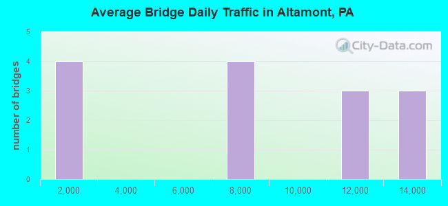
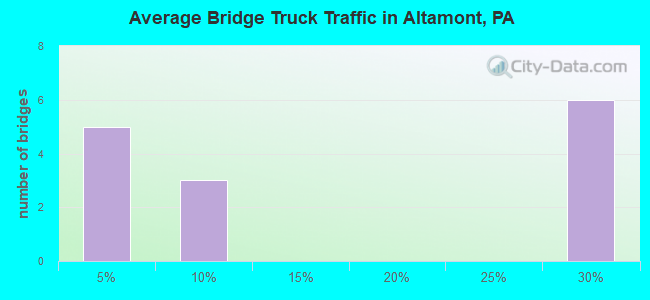
- 14Number of bridges
- 197ft / 59.5mTotal length
- $1,508,000Total costs
- 105,131Total average daily traffic
- 20,597Total average daily truck traffic
- National Bridge Inventory (NBI) Registered Bridges for Altamont
- No street view available for this location
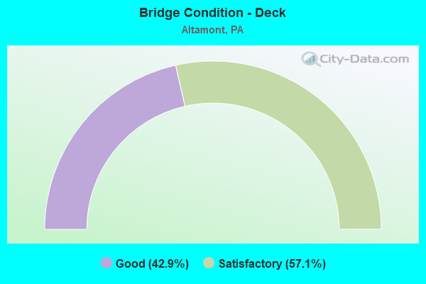
- Bridge Condition - Deck
- 42.9%Good
- 57.1%Satisfactory
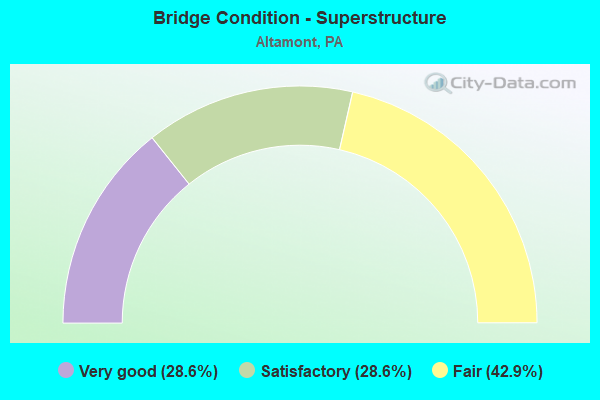
- Bridge Condition - Superstructure
- 28.6%Very good
- 28.6%Satisfactory
- 42.9%Fair
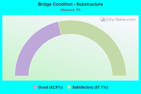
- Bridge Condition - Substructure
- 42.9%Good
- 57.1%Satisfactory
Find on map >> Show street view
Structure Number: 30583, Location: FRACKVILLE INTERCHANGE (Lat: 40.772992, Lng: -76.224364), Route carried "on" structure: Interstate 81, Year Built: 1967, Year Reconstructed: 2013, Status: Open, Structure Length: 7.50m (24.61ft), Average Daily Traffic: 12,352 (year 2021), Truck Traffic: 26%, Average Future Daily Traffic: 15,473 (year 2032), Design Load: HL 93, Features Intersected: PA61 (LR161) RAMPS B & F
Minimum Vertical Clearance: 30+ m (98+ ft), Kilometerpoint: 43.892, Lanes on structure: 3, Lanes under structure: 6, Base Highway Network: Yes, Owner: State Highway Agency, Approaching Roadway Width: 12.2m (40.0ft), Skew: 14 degrees, Material/Design: Prestressed concrete, Design/Construction: Box Beam or Girders - Single/Spread, Number Of Spans In Main Unit: 4, Length of Maximum Span: 24.1m (79.1ft), Curb or Sidewalk Widths: Left: 0.2m (0.7ft), Right: 0.2m (0.7ft), Curb-To-Curb Width: 13.3m (43.6ft), Out-to-Out Width: 15.1m (49.5ft)
Condition: Deck: Satisfactory, Superstructure: Very good, Substructure: Good, Operating Rating: 59.3 metric tons, Method Used To Determine Operating Rating: Assigned ratings based on Load and Resistance Factor Design (LRFD) reported by rating factor (RF) using HL93 loadings, Inventory Rating: 37.9 metric tons, Method Used To Determine Inventory Rating: Assigned ratings based on Load and Resistance Factor Design (LRFD) reported by rating factor (RF) using HL93 loadings, Structural Evaluation: Better than present minimum criteria, Deck Geometry: Meets minimum limits, Underclear: Equal to present minimum criteria, Approach Roadway Alignment: Equal to present desirable criteria, Length Of Structure Improvement: 8.50m (27.89ft), Designated Inspection Frequency: Every 24 months, Inspection Date: July 2020, Deck Structure Type: Concrete Cast-file-Place, Wearing Surface/Protective System: Wearing Surface: Monolithic Concrete, Deck Protection: Epoxy Coated Reinforcing
Find on map >> Show street view
Structure Number: 30585, Location: FRACKVILLE INTERCHANGE (Lat: 40.773217, Lng: -76.224697), Route carried "on" structure: Interstate 81, Year Built: 1967, Year Reconstructed: 2013, Status: Open, Structure Length: 7.13m (23.39ft), Average Daily Traffic: 11,998 (year 2021), Truck Traffic: 26%, Average Future Daily Traffic: 15,148 (year 2032), Design Load: HL 93, Features Intersected: PA61 & RAMP B,F,G
Minimum Vertical Clearance: 30+ m (98+ ft), Kilometerpoint: 43.813, Lanes on structure: 3, Lanes under structure: 6, Base Highway Network: Yes, Owner: State Highway Agency, Approaching Roadway Width: 12.2m (40.0ft), Skew: 14 degrees, Material/Design: Prestressed concrete, Design/Construction: Box Beam or Girders - Single/Spread, Number Of Spans In Main Unit: 4, Length of Maximum Span: 23.2m (76.1ft), Curb or Sidewalk Widths: Left: 0.2m (0.7ft), Right: 0.2m (0.7ft), Curb-To-Curb Width: 15.0m (49.2ft), Out-to-Out Width: 16.6m (54.5ft)
Condition: Deck: Good, Superstructure: Very good, Substructure: Good, Operating Rating: 59.3 metric tons, Method Used To Determine Operating Rating: Assigned ratings based on Load and Resistance Factor Design (LRFD) reported by rating factor (RF) using HL93 loadings, Inventory Rating: 37.3 metric tons, Method Used To Determine Inventory Rating: Assigned ratings based on Load and Resistance Factor Design (LRFD) reported by rating factor (RF) using HL93 loadings, Structural Evaluation: Better than present minimum criteria, Deck Geometry: Meets minimum limits, Underclear: High priority of corrective action, Approach Roadway Alignment: Equal to present desirable criteria, Length Of Structure Improvement: 8.00m (26.25ft), Designated Inspection Frequency: Every 24 months, Inspection Date: July 2020, Deck Structure Type: Concrete Cast-file-Place, Wearing Surface/Protective System: Wearing Surface: Monolithic Concrete, Deck Protection: Epoxy Coated Reinforcing
Find on map >> Show street view
Structure Number: 30587, Location: 0.2 MI.N.OF EX.124(36) NB (Lat: 40.773181, Lng: -76.221222), Route carried "on" structure: Interstate 81, Year Built: 1967, Year Reconstructed: 2011, Status: Open, Structure Length: 6.10m (20.01ft), Average Daily Traffic: 12,352 (year 2021), Truck Traffic: 26%, Average Future Daily Traffic: 15,473 (year 2032), Design Load: HL 93, Features Intersected: ALTAMONT BOULEVARD
Minimum Vertical Clearance: 30+ m (98+ ft), Kilometerpoint: 43.892, Lanes on structure: 2, Lanes under structure: 2, Base Highway Network: Yes, Owner: State Highway Agency, Approaching Roadway Width: 11.9m (39.0ft), Skew: 13 degrees, Material/Design: Prestressed concrete, Design/Construction: Box Beam or Girders - Single/Spread, Number Of Spans In Main Unit: 3, Length of Maximum Span: 23.2m (76.1ft), Curb or Sidewalk Widths: Left: 0.2m (0.7ft), Right: 0.2m (0.7ft), Curb-To-Curb Width: 11.7m (38.4ft), Out-to-Out Width: 13.0m (42.7ft)
Condition: Deck: Satisfactory, Superstructure: Fair, Substructure: Satisfactory, Operating Rating: 69.9 metric tons, Method Used To Determine Operating Rating: Assigned rating based on Load Factor Design (LFD) reported in metric tons, Inventory Rating: 33.6 metric tons, Method Used To Determine Inventory Rating: Assigned rating based on Load Factor Design (LFD) reported in metric tons, Structural Evaluation: Somewhat better than minimum adequacy, Deck Geometry: Equal to present minimum criteria, Underclear: Superior to present desirable criteria, Approach Roadway Alignment: Equal to present desirable criteria, Length Of Structure Improvement: 7.10m (23.29ft), Designated Inspection Frequency: Every 24 months, Inspection Date: October 2019, Bridge Improvement Cost: $70,000, Roadway Improvement Cost: $205,000, Total Project Cost: $940,000, Deck Structure Type: Concrete Cast-file-Place, Wearing Surface/Protective System: Wearing Surface: Latex Concrete
Find on map >> Show street view
Structure Number: 30588, Location: SCH. MALL RD. - EXIT 124 (Lat: 40.773403, Lng: -76.221364), Route carried "on" structure: Interstate 81, Year Built: 1967, Year Reconstructed: 2011, Status: Open, Structure Length: 5.27m (17.29ft), Average Daily Traffic: 11,998 (year 2021), Truck Traffic: 26%, Average Future Daily Traffic: 15,148 (year 2032), Design Load: HL 93, Features Intersected: ALTAMONT BOULEVARD
Minimum Vertical Clearance: 30+ m (98+ ft), Kilometerpoint: 43.813, Lanes on structure: 3, Lanes under structure: 2, Base Highway Network: Yes, Owner: State Highway Agency, Approaching Roadway Width: 12.2m (40.0ft), Skew: 13 degrees, Material/Design: Prestressed concrete, Design/Construction: Box Beam or Girders - Single/Spread, Number Of Spans In Main Unit: 3, Length of Maximum Span: 20.7m (67.9ft), Curb or Sidewalk Widths: Left: 0.2m (0.7ft), Right: 0.2m (0.7ft), Curb-To-Curb Width: 18.5m (60.7ft), Out-to-Out Width: 19.8m (65.0ft)
Condition: Deck: Satisfactory, Superstructure: Fair, Substructure: Satisfactory, Operating Rating: 62.6 metric tons, Method Used To Determine Operating Rating: Assigned ratings based on Load and Resistance Factor Design (LRFD) reported in metric tons, Inventory Rating: 33.6 metric tons, Method Used To Determine Inventory Rating: Assigned ratings based on Load and Resistance Factor Design (LRFD) reported in metric tons, Structural Evaluation: Somewhat better than minimum adequacy, Deck Geometry: Superior to present desirable criteria, Underclear: Equal to present desirable criteria, Approach Roadway Alignment: Equal to present desirable criteria, Length Of Structure Improvement: 6.30m (20.67ft), Designated Inspection Frequency: Every 24 months, Inspection Date: August 2020, Deck Structure Type: Concrete Cast-file-Place, Wearing Surface/Protective System: Wearing Surface: Latex Concrete
Find on map >> Show street view
Structure Number: 3059, Location: 2 MI. N. OF EXIT 124 (36) (Lat: 40.778789, Lng: -76.182450), Route carried "on" structure: Interstate 81, Year Built: 1968, Year Reconstructed: 2012, Status: Open, Structure Length: 15.70m (51.51ft), Average Daily Traffic: 12,352 (year 2021), Truck Traffic: 26%, Average Future Daily Traffic: 15,473 (year 2032), Design Load: HL 93, Features Intersected: ACCESS ROAD & MILL CREEK
Minimum Vertical Clearance: 30+ m (98+ ft), Kilometerpoint: 47.138, Lanes on structure: 2, Base Highway Network: Yes, Owner: State Highway Agency, Approaching Roadway Width: 9.4m (30.8ft), Skew: 1 degrees, Material/Design: Steel continuous, Design/Construction: Stringer/Multi-beam, Number Of Spans In Main Unit: 4, Length of Maximum Span: 41.8m (137.1ft), Curb or Sidewalk Widths: Left: 0.2m (0.7ft), Right: 0.2m (0.7ft), Curb-To-Curb Width: 10.1m (33.1ft), Out-to-Out Width: 11.1m (36.4ft)
Condition: Deck: Good, Superstructure: Satisfactory, Substructure: Satisfactory, Channel: Very good, Operating Rating: 77.1 metric tons, Method Used To Determine Operating Rating: Assigned rating based on Load Factor Design (LFD) reported in metric tons, Inventory Rating: 46.3 metric tons, Method Used To Determine Inventory Rating: Assigned rating based on Load Factor Design (LFD) reported in metric tons, Structural Evaluation: Equal to present minimum criteria, Deck Geometry: Meets minimum limits, Waterway Adequacy: Superior to present desirable criteria, Approach Roadway Alignment: Equal to present desirable criteria, Length Of Structure Improvement: 16.00m (52.49ft), Designated Inspection Frequency: Every 24 months, Inspection Date: October 2020, Bridge Improvement Cost: $42,000, Roadway Improvement Cost: $124,000, Total Project Cost: $568,000, Deck Structure Type: Concrete Cast-file-Place, Wearing Surface/Protective System: Wearing Surface: Monolithic Concrete, Deck Protection: Epoxy Coated Reinforcing
Find on map >> Show street view
Structure Number: 30591, Location: 2 MI. N. OF EXIT 124 (36) (Lat: 40.779453, Lng: -76.182361), Route carried "on" structure: Interstate 81, Year Built: 1968, Year Reconstructed: 2012, Status: Open, Structure Length: 12.74m (41.80ft), Average Daily Traffic: 11,998 (year 2021), Truck Traffic: 26%, Average Future Daily Traffic: 15,148 (year 2032), Design Load: HS 20+Mod, Features Intersected: MILL CREEK/ACCESS RD
Minimum Vertical Clearance: 30+ m (98+ ft), Kilometerpoint: 47.068, Lanes on structure: 2, Base Highway Network: Yes, Owner: State Highway Agency, Approaching Roadway Width: 11.0m (36.1ft), Skew: 1 degrees, Material/Design: Steel continuous, Design/Construction: Stringer/Multi-beam, Number Of Spans In Main Unit: 4, Length of Maximum Span: 37.8m (124.0ft), Curb or Sidewalk Widths: Left: 0.2m (0.7ft), Right: 0.2m (0.7ft), Curb-To-Curb Width: 10.1m (33.1ft), Out-to-Out Width: 11.1m (36.4ft)
Condition: Deck: Good, Superstructure: Satisfactory, Substructure: Good, Channel: Very good, Operating Rating: 73.5 metric tons, Method Used To Determine Operating Rating: Load Factor (LF), Inventory Rating: 43.5 metric tons, Method Used To Determine Inventory Rating: Load Factor (LF), Structural Evaluation: Equal to present minimum criteria, Deck Geometry: Meets minimum limits, Waterway Adequacy: Superior to present desirable criteria, Approach Roadway Alignment: Equal to present desirable criteria, Length Of Structure Improvement: 13.20m (43.31ft), Designated Inspection Frequency: Every 48 months, Inspection Date: October 2018, Deck Structure Type: Concrete Cast-file-Place, Wearing Surface/Protective System: Wearing Surface: Monolithic Concrete, Deck Protection: Epoxy Coated Reinforcing
Find on map >> Show street view
Structure Number: 31028, Location: FRACKVILLE INTERCHANGE (Lat: 40.773183, Lng: -76.219739), Route carried "on" structure: Ramp State highway , Year Built: 1967, Year Reconstructed: 2011, Status: Open, Structure Length: 5.06m (16.60ft), Average Daily Traffic: 1,441 (year 2021), Truck Traffic: 7%, Average Future Daily Traffic: 2,042 (year 2032), Design Load: HS 20, Features Intersected: ALTAMONT BOULEVARD, Facility Carried by Structure: I-81 RAMP
Minimum Vertical Clearance: 30+ m (98+ ft), Kilometerpoint: 0.000, Lanes on structure: 1, Lanes under structure: 2, Base Highway Network: Yes, Owner: State Highway Agency, Approaching Roadway Width: 9.1m (29.9ft), Skew: 9 degrees, Material/Design: Prestressed concrete, Design/Construction: Box Beam or Girders - Single/Spread, Number Of Spans In Main Unit: 3, Length of Maximum Span: 20.1m (65.9ft), Curb or Sidewalk Widths: Left: 0.2m (0.7ft), Right: 0.2m (0.7ft), Curb-To-Curb Width: 8.7m (28.5ft), Out-to-Out Width: 9.9m (32.5ft)
Condition: Deck: Satisfactory, Superstructure: Fair, Substructure: Satisfactory, Operating Rating: 97.1 metric tons, Method Used To Determine Operating Rating: Load Factor (LF), Inventory Rating: 39.0 metric tons, Method Used To Determine Inventory Rating: Load Factor (LF), Structural Evaluation: Somewhat better than minimum adequacy, Deck Geometry: Superior to present desirable criteria, Underclear: Meets minimum limits, Approach Roadway Alignment: Better than present minimum criteria, Length Of Structure Improvement: 6.30m (20.67ft), Designated Inspection Frequency: Every 24 months, Inspection Date: April 2020, Deck Structure Type: Concrete Cast-file-Place, Wearing Surface/Protective System: Wearing Surface: Latex Concrete
Find on map >> Show street view
Structure Number: 30583, Location: FRACKVILLE INTERCHANGE (Lat: 40.772992, Lng: -76.224364), Route carried "under" structure: State highway 61, Year Built: 1967, Structure Length: 0. m, Average Daily Traffic: 7,590 (year 2021), Truck Traffic: 4%, Features Intersected: PA61 (LR161) RAMPS B & F, Facility Carried by Structure: I-81 NB (LR 1005)
Minimum Vertical Clearance: 5.52m (18.11ft), Kilometerpoint: 36.477, Lanes on structure: 3, Lanes under structure: 3, Material/Design: Prestressed concrete, Design/Construction: Box Beam or Girders - Single/Spread, Length of Maximum Span: 24.1m (79.1ft)
Find on map >> Show street view
Structure Number: 30583, Location: FRACKVILLE INTERCHANGE (Lat: 40.772992, Lng: -76.224364), Route carried "under" structure: State highway 61, Year Built: 1967, Structure Length: 0. m, Average Daily Traffic: 7,480 (year 2021), Truck Traffic: 6%, Features Intersected: PA61 (LR161) RAMPS B & F, Facility Carried by Structure: I-81 NB (LR 1005)
Minimum Vertical Clearance: 5.06m (16.60ft), Kilometerpoint: 36.510, Lanes on structure: 3, Lanes under structure: 3, Material/Design: Prestressed concrete, Design/Construction: Box Beam or Girders - Single/Spread, Length of Maximum Span: 24.1m (79.1ft)
Find on map >> Show street view
Structure Number: 30585, Location: FRACKVILLE INTERCHANGE (Lat: 40.773217, Lng: -76.224697), Route carried "under" structure: State highway 61, Year Built: 1967, Structure Length: 0. m, Average Daily Traffic: 7,590 (year 2021), Truck Traffic: 4%, Features Intersected: PA61 & RAMP B,F,G, Facility Carried by Structure: I-81 SB (LR 1005)
Minimum Vertical Clearance: 5.36m (17.59ft), Kilometerpoint: 36.477, Lanes on structure: 3, Lanes under structure: 3, Material/Design: Prestressed concrete, Design/Construction: Box Beam or Girders - Single/Spread, Length of Maximum Span: 23.2m (76.1ft)
Find on map >> Show street view
Structure Number: 30585, Location: FRACKVILLE INTERCHANGE (Lat: 40.773217, Lng: -76.224697), Route carried "under" structure: State highway 61, Year Built: 1967, Structure Length: 0. m, Average Daily Traffic: 7,480 (year 2021), Truck Traffic: 6%, Features Intersected: PA61 & RAMP B,F,G, Facility Carried by Structure: I-81 SB (LR 1005)
Minimum Vertical Clearance: 5.03m (16.50ft), Kilometerpoint: 36.510, Lanes on structure: 3, Lanes under structure: 3, Material/Design: Prestressed concrete, Design/Construction: Box Beam or Girders - Single/Spread, Length of Maximum Span: 23.2m (76.1ft)
Find on map >> Show street view
Structure Number: 30587, Location: 0.2 MI.N.OF EX.124(36) NB (Lat: 40.773181, Lng: -76.221222), Route carried "under" structure: ServiceOther road , Year Built: 1967, Structure Length: 0. m, Average Daily Traffic: 200 (year 1992), Truck Traffic: 1%, Features Intersected: ALTAMONT BOULEVARD, Facility Carried by Structure: I-81 NB(LR1005)
Minimum Vertical Clearance: 9.05m (29.69ft), Kilometerpoint: 0.000, Lanes on structure: 2, Lanes under structure: 2, Material/Design: Prestressed concrete, Design/Construction: Box Beam or Girders - Single/Spread, Length of Maximum Span: 23.2m (76.1ft)
Find on map >> Show street view
Structure Number: 30588, Location: SCH. MALL RD. - EXIT 124 (Lat: 40.773403, Lng: -76.221364), Route carried "under" structure: ServiceCity street , Year Built: 1967, Structure Length: 0. m, Average Daily Traffic: 200 (year 1992), Truck Traffic: 1%, Features Intersected: ALTAMONT BOULEVARD, Facility Carried by Structure: I-81 SB (LR 1005)
Minimum Vertical Clearance: 6.74m (22.11ft), Kilometerpoint: 0.000, Lanes on structure: 3, Lanes under structure: 2, Material/Design: Prestressed concrete, Design/Construction: Box Beam or Girders - Single/Spread, Length of Maximum Span: 20.7m (67.9ft)
Find on map >> Show street view
Structure Number: 31028, Location: FRACKVILLE INTERCHANGE (Lat: 40.773183, Lng: -76.219739), Route carried "under" structure: ServiceOther road LOCL, Year Built: 1967, Structure Length: 0. m, Average Daily Traffic: 100 (year 1991), Truck Traffic: 1%, Features Intersected: ALTAMONT BOULEVARD, Facility Carried by Structure: I-81 RAMP
Minimum Vertical Clearance: 7.47m (24.51ft), Kilometerpoint: 0.000, Lanes on structure: 1, Lanes under structure: 2, Material/Design: Prestressed concrete, Design/Construction: Box Beam or Girders - Single/Spread, Length of Maximum Span: 20.1m (65.9ft)