Bridge Statistics for Alorton, Illinois (IL)
Condition, Traffic, Stress, Structural Evaluation, Project Costs
- National Bridge Inventory (NBI) Statistics
- 13Number of bridges
- 121ft / 37.1mTotal length
- 249,450Total average daily traffic
- 35,594Total average daily truck traffic
- National Bridge Inventory (NBI) Registered Bridges for Alorton
- No street view available for this location
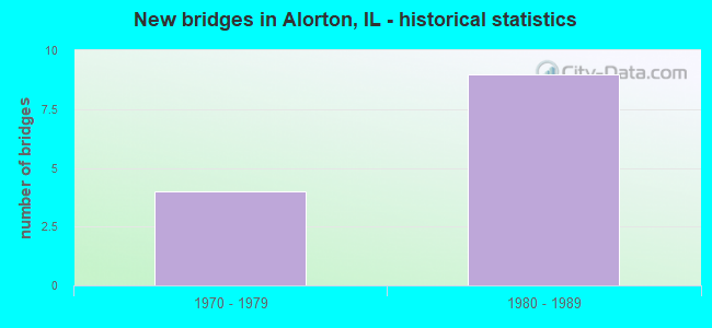
- New bridges - historical statistics
- 41970-1979
- 91980-1989


- Bridge Condition - Deck
- 37.5%Very good
- 37.5%Good
- 25.0%Satisfactory

- Bridge Condition - Superstructure
- 25.0%Very good
- 12.5%Satisfactory
- 25.0%Fair
- 25.0%Poor
- 12.5%Critical

- Bridge Condition - Substructure
- 12.5%Very good
- 50.0%Good
- 37.5%Satisfactory
Find on map >> Show street view
Structure Number: 820228, Location: S OF ILL 15/MO.AVE (Lat: 38.577317, Lng: -90.114650), Route carried "on" structure: Interstate 255, Year Built: 1979, Status: Open, Structure Length: 3.25m (10.66ft), Average Daily Traffic: 45,000 (year 2021), Truck Traffic: 16%, Average Future Daily Traffic: 44,769 (year 2032), Design Load: HS 20+Mod, Features Intersected: BOND AVE
Minimum Vertical Clearance: 30+ m (98+ ft), Kilometerpoint: 20.036, Lanes on structure: 6, Lanes under structure: 2, Base Highway Network: Yes, Owner: State Highway Agency, Approaching Roadway Width: 34.1m (111.9ft), Skew: 30 degrees, Material/Design: Steel continuous, Design/Construction: Stringer/Multi-beam, Number Of Spans In Main Unit: 3, Length of Maximum Span: 32.0m (105.0ft), Curb-To-Curb Width: 35.8m (117.5ft), Out-to-Out Width: 36.9m (121.1ft)
Condition: Deck: Very good, Superstructure: Satisfactory, Substructure: Satisfactory, Operating Rating: 79.7 metric tons, Method Used To Determine Operating Rating: Load Factor (LF) rating reported by rating factor (RF) method using MS18 loading, Inventory Rating: 47.6 metric tons, Method Used To Determine Inventory Rating: Load Factor (LF) rating reported by rating factor (RF) method using MS18 loading, Structural Evaluation: Equal to present minimum criteria, Deck Geometry: Superior to present desirable criteria, Underclear: Equal to present minimum criteria, Approach Roadway Alignment: Equal to present desirable criteria, Designated Inspection Frequency: Every 24 months, Inspection Date: January 2021, Deck Structure Type: Concrete Cast-file-Place, Wearing Surface/Protective System: Deck Protection: Epoxy Coated Reinforcing
Find on map >> Show street view
Structure Number: 820229, Location: 1/2 Mi SO ILL 15 (Lat: 38.578786, Lng: -90.112686), Route carried "on" structure: Interstate 255, Year Built: 1980, Status: Temporarily open, Structure Length: 4.79m (15.72ft), Average Daily Traffic: 45,000 (year 2021), Truck Traffic: 16%, Average Future Daily Traffic: 44,769 (year 2032), Design Load: HS 20+Mod, Features Intersected: Norfolk Southern RR
Minimum Vertical Clearance: 30+ m (98+ ft), Kilometerpoint: 20.277, Lanes on structure: 6, Base Highway Network: Yes, Owner: State Highway Agency, Approaching Roadway Width: 29.9m (98.1ft), Skew: 30 degrees, Material/Design: Steel continuous, Design/Construction: Stringer/Multi-beam, Number Of Spans In Main Unit: 3, Length of Maximum Span: 18.1m (59.4ft), Curb-To-Curb Width: 38.8m (127.3ft), Out-to-Out Width: 39.8m (130.6ft)
Condition: Deck: Satisfactory, Superstructure: Critical, Substructure: Good, Operating Rating: 33.4 metric tons, Method Used To Determine Operating Rating: Load Factor (LF) rating reported by rating factor (RF) method using MS18 loading, Inventory Rating: 20.1 metric tons, Method Used To Determine Inventory Rating: Load Factor (LF) rating reported by rating factor (RF) method using MS18 loading, Structural Evaluation: High priority of replacement, Deck Geometry: Superior to present desirable criteria, Underclear: Equal to present desirable criteria, Approach Roadway Alignment: Equal to present desirable criteria, Designated Inspection Frequency: Every 12 months, Other Special Inspection Frequency: Every 6 months, Inspection Date: January 2022, Other Special Inspection Date: January 2022, Deck Structure Type: Concrete Cast-file-Place, Wearing Surface/Protective System: Deck Protection: Epoxy Coated Reinforcing
Find on map >> Show street view
Structure Number: 82023, Location: 1/4 mi S of IL 15 (Lat: 38.580650, Lng: -90.110200), Route carried "on" structure: Interstate 255, Year Built: 1980, Status: Open, Structure Length: 3.86m (12.66ft), Average Daily Traffic: 45,000 (year 2021), Truck Traffic: 16%, Average Future Daily Traffic: 44,769 (year 2032), Design Load: HS 20+Mod, Features Intersected: ILL 163
Minimum Vertical Clearance: 30+ m (98+ ft), Kilometerpoint: 20.583, Lanes on structure: 6, Lanes under structure: 2, Base Highway Network: Yes, Owner: State Highway Agency, Approaching Roadway Width: 34.1m (111.9ft), Skew: 30 degrees, Material/Design: Steel, Design/Construction: Stringer/Multi-beam, Number Of Spans In Main Unit: 1, Length of Maximum Span: 38.1m (125.0ft), Curb-To-Curb Width: 35.9m (117.8ft), Out-to-Out Width: 36.9m (121.1ft)
Condition: Deck: Good, Superstructure: Poor, Substructure: Satisfactory, Operating Rating: 91.0 metric tons, Method Used To Determine Operating Rating: Load Factor (LF) rating reported by rating factor (RF) method using MS18 loading, Inventory Rating: 54.4 metric tons, Method Used To Determine Inventory Rating: Load Factor (LF) rating reported by rating factor (RF) method using MS18 loading, Structural Evaluation: Meets minimum limits, Deck Geometry: Superior to present desirable criteria, Underclear: Equal to present minimum criteria, Approach Roadway Alignment: Equal to present desirable criteria, Designated Inspection Frequency: Every 12 months, Inspection Date: January 2022, Deck Structure Type: Concrete Cast-file-Place, Wearing Surface/Protective System: Deck Protection: Epoxy Coated Reinforcing
Find on map >> Show street view
Structure Number: 820231, Location: 1.3 MI S OF STATE ST (Lat: 38.582400, Lng: -90.107842), Route carried "on" structure: Interstate 255, Year Built: 1981, Status: Open, Structure Length: 6.19m (20.31ft), Average Daily Traffic: 47,800 (year 2021), Truck Traffic: 17%, Average Future Daily Traffic: 46,965 (year 2032), Design Load: HS 20, Features Intersected: ILL 15
Minimum Vertical Clearance: 30+ m (98+ ft), Kilometerpoint: 20.857, Lanes on structure: 6, Lanes under structure: 6, Base Highway Network: Yes, Owner: State Highway Agency, Approaching Roadway Width: 34.1m (111.9ft), Skew: 30 degrees, Material/Design: Steel continuous, Design/Construction: Stringer/Multi-beam, Number Of Spans In Main Unit: 2, Number Of Approach Spans: 2, Length of Maximum Span: 32.0m (105.0ft), Curb-To-Curb Width: 42.2m (138.5ft), Out-to-Out Width: 45.0m (147.6ft)
Condition: Deck: Satisfactory, Superstructure: Poor, Substructure: Good, Operating Rating: 74.5 metric tons, Method Used To Determine Operating Rating: Load Factor (LF) rating reported by rating factor (RF) method using MS18 loading, Inventory Rating: 44.7 metric tons, Method Used To Determine Inventory Rating: Load Factor (LF) rating reported by rating factor (RF) method using MS18 loading, Structural Evaluation: Meets minimum limits, Deck Geometry: Superior to present desirable criteria, Underclear: Somewhat better than minimum adequacy, Approach Roadway Alignment: Equal to present desirable criteria, Designated Inspection Frequency: Every 12 months, Inspection Date: January 2022, Deck Structure Type: Concrete Cast-file-Place, Wearing Surface/Protective System: Deck Protection: Epoxy Coated Reinforcing
Find on map >> Show street view
Structure Number: 820259, Location: 050 MI NW ILL 163 (Lat: 38.593722, Lng: -90.120783), Route carried "on" structure: State highway 15, Year Built: 1980, Status: Open, Structure Length: 5.88m (19.29ft), Average Daily Traffic: 12,400 (year 2021), Truck Traffic: 9%, Average Future Daily Traffic: 18,828 (year 2032), Design Load: HS 20, Features Intersected: A&S RAILROAD
Minimum Vertical Clearance: 30+ m (98+ ft), Kilometerpoint: 5.520, Lanes on structure: 4, Base Highway Network: Yes, Owner: State Highway Agency, Approaching Roadway Width: 21.9m (71.9ft), Skew: 30 degrees, Material/Design: Steel continuous, Design/Construction: Stringer/Multi-beam, Number Of Spans In Main Unit: 3, Length of Maximum Span: 23.2m (76.1ft), Curb-To-Curb Width: 21.9m (71.9ft), Out-to-Out Width: 27.2m (89.2ft)
Condition: Deck: Good, Superstructure: Very good, Substructure: Satisfactory, Operating Rating: 55.4 metric tons, Method Used To Determine Operating Rating: Load Factor (LF) rating reported by rating factor (RF) method using MS18 loading, Inventory Rating: 27.9 metric tons, Method Used To Determine Inventory Rating: Load Factor (LF) rating reported by rating factor (RF) method using MS18 loading, Structural Evaluation: Equal to present minimum criteria, Deck Geometry: Superior to present desirable criteria, Underclear: Equal to present desirable criteria, Approach Roadway Alignment: Equal to present desirable criteria, Designated Inspection Frequency: Every 24 months, Inspection Date: March 2020, Deck Structure Type: Concrete Cast-file-Place, Wearing Surface/Protective System: Deck Protection: Epoxy Coated Reinforcing
Find on map >> Show street view
Structure Number: 82026, Location: 0.2mi S of IL 15 (Lat: 38.581231, Lng: -90.110900), Route carried "on" structure: Other road , Year Built: 1979, Status: Open, Structure Length: 3.65m (11.98ft), Average Daily Traffic: 1,100 (year 2018), Truck Traffic: 5%, Average Future Daily Traffic: 994 (year 2032), Design Load: HS 20, Features Intersected: IL 163, Facility Carried by Structure: IL15 Ramp G to SB2
Minimum Vertical Clearance: 30+ m (98+ ft), Kilometerpoint: 0.708, Lanes on structure: 1, Lanes under structure: 2, Base Highway Network: Yes (Inventory Route: 10255040, Subroute: 40), Owner: State Highway Agency, Approaching Roadway Width: 8.2m (26.9ft), Skew: 4 degrees, Material/Design: Steel, Design/Construction: Stringer/Multi-beam, Number Of Spans In Main Unit: 1, Number Of Approach Spans: 2, Length of Maximum Span: 36.0m (118.1ft), Curb-To-Curb Width: 7.9m (25.9ft), Out-to-Out Width: 8.9m (29.2ft)
Condition: Deck: Very good, Superstructure: Fair, Substructure: Good, Operating Rating: 57.3 metric tons, Method Used To Determine Operating Rating: Load Factor (LF) rating reported by rating factor (RF) method using MS18 loading, Inventory Rating: 34.3 metric tons, Method Used To Determine Inventory Rating: Load Factor (LF) rating reported by rating factor (RF) method using MS18 loading, Structural Evaluation: Somewhat better than minimum adequacy, Deck Geometry: Meets minimum limits, Underclear: Equal to present minimum criteria, Approach Roadway Alignment: Equal to present desirable criteria, Designated Inspection Frequency: Every 24 months, Inspection Date: January 2021, Deck Structure Type: Concrete Cast-file-Place, Wearing Surface/Protective System: Deck Protection: Epoxy Coated Reinforcing
Find on map >> Show street view
Structure Number: 820262, Location: 0.2mi S of IL 15 (Lat: 38.580381, Lng: -90.109961), Route carried "on" structure: Other road , Year Built: 1980, Status: Open, Structure Length: 3.58m (11.75ft), Average Daily Traffic: 6,500 (year 2018), Truck Traffic: 10%, Average Future Daily Traffic: 6,276 (year 2032), Design Load: HS 20, Features Intersected: IL 163, Facility Carried by Structure: 255NB Ramp E to IL
Minimum Vertical Clearance: 30+ m (98+ ft), Kilometerpoint: 0.338, Lanes on structure: 1, Lanes under structure: 2, Base Highway Network: Yes (Inventory Route: 10255040, Subroute: 40), Owner: State Highway Agency, Approaching Roadway Width: 7.9m (25.9ft), Material/Design: Steel, Design/Construction: Stringer/Multi-beam, Number Of Spans In Main Unit: 1, Number Of Approach Spans: 2, Length of Maximum Span: 35.1m (115.2ft), Curb-To-Curb Width: 7.9m (25.9ft), Out-to-Out Width: 8.9m (29.2ft)
Condition: Deck: Good, Superstructure: Fair, Substructure: Good, Operating Rating: 97.2 metric tons, Method Used To Determine Operating Rating: Load Factor (LF) rating reported by rating factor (RF) method using MS18 loading, Inventory Rating: 58.6 metric tons, Method Used To Determine Inventory Rating: Load Factor (LF) rating reported by rating factor (RF) method using MS18 loading, Structural Evaluation: Somewhat better than minimum adequacy, Deck Geometry: High priority of replacement, Underclear: Equal to present minimum criteria, Approach Roadway Alignment: Equal to present minimum criteria, Designated Inspection Frequency: Every 24 months, Inspection Date: January 2021, Deck Structure Type: Concrete Cast-file-Place, Wearing Surface/Protective System: Deck Protection: Epoxy Coated Reinforcing
Find on map >> Show street view
Structure Number: 820267, Location: 39TH & BOND ALORTON (Lat: 38.589086, Lng: -90.127581), Route carried "on" structure: Other road , Year Built: 1980, Status: Open, Structure Length: 5.91m (19.39ft), Average Daily Traffic: 4,000 (year 2018), Truck Traffic: 7%, Average Future Daily Traffic: 4,759 (year 2032), Design Load: HS 20, Features Intersected: ALTON&SOUTHERN RR, Facility Carried by Structure: BOND AVE/ FAU 9189
Minimum Vertical Clearance: 30+ m (98+ ft), Kilometerpoint: 4.265, Lanes on structure: 2, Base Highway Network: Yes, Owner: State Highway Agency, Approaching Roadway Width: 7.9m (25.9ft), Material/Design: Steel continuous, Design/Construction: Stringer/Multi-beam, Number Of Spans In Main Unit: 3, Length of Maximum Span: 23.0m (75.5ft), Curb or Sidewalk Widths: Left: 0.0m, Right: 1.5m (4.9ft), Curb-To-Curb Width: 9.4m (30.8ft), Out-to-Out Width: 11.8m (38.7ft)
Condition: Deck: Very good, Superstructure: Very good, Substructure: Very good, Operating Rating: 71.0 metric tons, Method Used To Determine Operating Rating: Load Factor (LF) rating reported by rating factor (RF) method using MS18 loading, Inventory Rating: 42.4 metric tons, Method Used To Determine Inventory Rating: Load Factor (LF) rating reported by rating factor (RF) method using MS18 loading, Structural Evaluation: Equal to present desirable criteria, Deck Geometry: Meets minimum limits, Underclear: Equal to present desirable criteria, Approach Roadway Alignment: Somewhat better than minimum adequacy, Designated Inspection Frequency: Every 48 months, Inspection Date: August 2020, Deck Structure Type: Concrete Cast-file-Place, Wearing Surface/Protective System: Wearing Surface: Bituminous, Membrane: Built-up, Deck Protection: Epoxy Coated Reinforcing
Find on map >> Show street view
Structure Number: 820228, Location: S OF ILL 15/MO.AVE (Lat: 38.577317, Lng: -90.114650), Route carried "under" structure: Other road , Year Built: 1979, Structure Length: 0. m, Average Daily Traffic: 4,600 (year 2018), Truck Traffic: 4%, Features Intersected: BOND AVE, Facility Carried by Structure: FAI 255
Minimum Vertical Clearance: 4.57m (14.99ft), Kilometerpoint: 6.003, Lanes on structure: 6, Lanes under structure: 2, Material/Design: Steel continuous, Design/Construction: Stringer/Multi-beam, Length of Maximum Span: 32.0m (105.0ft)
Find on map >> Show street view
Structure Number: 82023, Location: 1/4 mi S of IL 15 (Lat: 38.580650, Lng: -90.110200), Route carried "under" structure: State highway 163, Year Built: 1980, Structure Length: 0. m, Average Daily Traffic: 2,450 (year 2021), Truck Traffic: 7%, Features Intersected: ILL 163, Facility Carried by Structure: FAI 255
Minimum Vertical Clearance: 6.63m (21.75ft), Kilometerpoint: 14.419, Lanes on structure: 6, Lanes under structure: 2, Material/Design: Steel, Design/Construction: Stringer/Multi-beam, Length of Maximum Span: 38.1m (125.0ft)
Find on map >> Show street view
Structure Number: 820231, Location: 1.3 MI S OF STATE ST (Lat: 38.582400, Lng: -90.107842), Route carried "under" structure: State highway 15, Year Built: 1981, Structure Length: 0. m, Average Daily Traffic: 30,700 (year 2021), Truck Traffic: 10%, Features Intersected: ILL 15, Facility Carried by Structure: FAI 255
Minimum Vertical Clearance: 5.77m (18.93ft), Kilometerpoint: 7.210, Lanes on structure: 6, Lanes under structure: 6, Material/Design: Steel continuous, Design/Construction: Stringer/Multi-beam, Length of Maximum Span: 32.0m (105.0ft)
Find on map >> Show street view
Structure Number: 82026, Location: 0.2mi S of IL 15 (Lat: 38.581231, Lng: -90.110900), Route carried "under" structure: State highway 163, Year Built: 1979, Structure Length: 0. m, Average Daily Traffic: 2,450 (year 2021), Truck Traffic: 7%, Features Intersected: IL 163, Facility Carried by Structure: IL15 Ramp G to SB2
Minimum Vertical Clearance: 5.21m (17.09ft), Kilometerpoint: 14.500, Lanes on structure: 1, Lanes under structure: 2, Material/Design: Steel, Design/Construction: Stringer/Multi-beam, Length of Maximum Span: 36.0m (118.1ft)
Find on map >> Show street view
Structure Number: 820262, Location: 0.2mi S of IL 15 (Lat: 38.580381, Lng: -90.109961), Route carried "under" structure: State highway 163, Year Built: 1980, Structure Length: 0. m, Average Daily Traffic: 2,450 (year 2021), Truck Traffic: 7%, Features Intersected: IL 163, Facility Carried by Structure: 255NB Ramp E to IL
Minimum Vertical Clearance: 6.25m (20.51ft), Kilometerpoint: 14.371, Lanes on structure: 1, Lanes under structure: 2, Material/Design: Steel, Design/Construction: Stringer/Multi-beam, Length of Maximum Span: 35.1m (115.2ft)