Bridge Statistics for Almont, Michigan (MI)
Condition, Traffic, Stress, Structural Evaluation, Project Costs
- National Bridge Inventory (NBI) Statistics
- 12Number of bridges
- 79ft / 23.6mTotal length
- $638,000Total costs
- 98,133Total average daily traffic
- 7,239Total average daily truck traffic
- National Bridge Inventory (NBI) Registered Bridges for Almont
- No street view available for this location
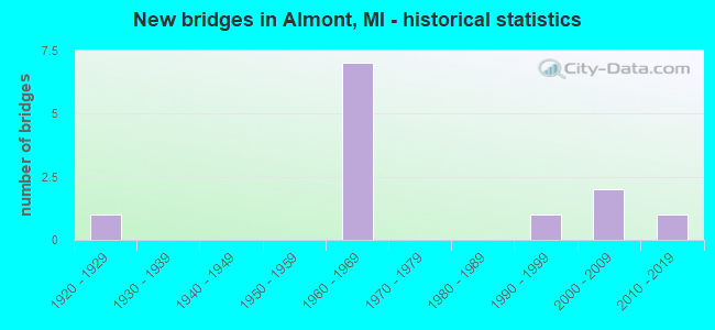
- New bridges - historical statistics
- 11920-1929
- 71960-1969
- 11990-1999
- 22000-2009
- 12010-2019


- Bridge Condition - Deck
- 50.0%Good
- 50.0%Satisfactory

- Bridge Condition - Superstructure
- 16.7%Very good
- 33.3%Satisfactory
- 50.0%Fair

- Bridge Condition - Substructure
- 33.3%Good
- 50.0%Satisfactory
- 16.7%Fair

- Bridge Condition - Channel
- 33.3%Good
- 22.2%Satisfactory
- 44.4%Fair

- Bridge Condition - Culverts
- 20.0%Very good
- 40.0%Good
- 20.0%Satisfactory
- 20.0%Serious
Find on map >> Show street view
Structure Number: 604, Location: 4.0 MI N OF SAGINAW COL (Lat: 43.580597, Lng: -83.948628), Route carried "on" structure: County highway 2008, Year Built: 1960, Status: Open, Structure Length: 6.46m (21.19ft), Average Daily Traffic: 5,197 (year 1997), Truck Traffic: 3%, Average Future Daily Traffic: 6,230 (year 1977), Design Load: H 15, Features Intersected: I-75, Facility Carried by Structure: SALZBURG RD
Minimum Vertical Clearance: 30.48m (100.00ft), Kilometerpoint: 17.711, Lanes on structure: 2, Lanes under structure: 6, Owner: State Highway Agency, Approaching Roadway Width: 13.1m (43.0ft), Material/Design: Steel, Design/Construction: Stringer/Multi-beam, Number Of Spans In Main Unit: 4, Length of Maximum Span: 21.5m (70.5ft), Curb-To-Curb Width: 7.9m (25.9ft), Out-to-Out Width: 10.2m (33.5ft)
Condition: Deck: Satisfactory, Superstructure: Satisfactory, Substructure: Satisfactory, Operating Rating: 57.3 metric tons, Method Used To Determine Operating Rating: Load Factor (LF), Inventory Rating: 34.3 metric tons, Method Used To Determine Inventory Rating: Load Factor (LF), Structural Evaluation: Equal to present minimum criteria, Deck Geometry: High priority of corrective action, Underclear: High priority of replacement, Approach Roadway Alignment: Somewhat better than minimum adequacy, Length Of Structure Improvement: 6.16m (20.21ft), Designated Inspection Frequency: Every 24 months, Inspection Date: Febuary 2021, Bridge Improvement Cost: $959,000, Roadway Improvement Cost: $49,000, Total Project Cost: $576,000, Deck Structure Type: Concrete Cast-file-Place, Wearing Surface/Protective System: Wearing Surface: Epoxy Overlay, Deck Protection: Epoxy Coated Reinforcing
Find on map >> Show street view
Structure Number: 2613, Location: 1.2 MI N OF RICHFIELD CEN (Lat: 43.111164, Lng: -83.518853), Route carried "on" structure: State highway 15, Year Built: 1928, Year Reconstructed: 1978, Status: Open, Structure Length: 3.35m (10.99ft), Average Daily Traffic: 8,725 (year 2013), Truck Traffic: 9%, Average Future Daily Traffic: 9,625 (year 2033), Design Load: HS 20, Features Intersected: FLINT RIVER
Minimum Vertical Clearance: 30.48m (100.00ft), Kilometerpoint: 27.226, Lanes on structure: 2, Base Highway Network: Yes (Inventory Route: 150, Subroute: 2), Owner: State Highway Agency, Approaching Roadway Width: 11.8m (38.7ft), Material/Design: Steel, Design/Construction: Stringer/Multi-beam, Number Of Spans In Main Unit: 2, Length of Maximum Span: 16.7m (54.8ft), Curb-To-Curb Width: 11.8m (38.7ft), Out-to-Out Width: 13.0m (42.7ft)
Condition: Deck: Satisfactory, Superstructure: Fair, Substructure: Fair, Channel: Fair, Operating Rating: 55.1 metric tons, Method Used To Determine Operating Rating: Load Factor (LF) rating reported by rating factor (RF) method using MS18 loading, Inventory Rating: 33.0 metric tons, Method Used To Determine Inventory Rating: Load Factor (LF) rating reported by rating factor (RF) method using MS18 loading, Structural Evaluation: Somewhat better than minimum adequacy, Deck Geometry: Somewhat better than minimum adequacy, Waterway Adequacy: Equal to present desirable criteria, Approach Roadway Alignment: Equal to present desirable criteria, Designated Inspection Frequency: Every 24 months, Underwater Inspection Frequency: Every 60 months, Inspection Date: August 2021, Underwater Inspection Date: August 2020, Deck Structure Type: Concrete Cast-file-Place, Wearing Surface/Protective System: Wearing Surface: Epoxy Overlay
Find on map >> Show street view
Structure Number: 3782, Location: 1.6MI S OF LANSING (JOLLY (Lat: 42.682869, Lng: -84.500447), Route carried "on" structure: Interstate 496, Year Built: 1963, Status: Open, Structure Length: 4.74m (15.55ft), Average Daily Traffic: 28,350 (year 2008), Truck Traffic: 9%, Average Future Daily Traffic: 27,038 (year 2018), Design Load: HS 20+Mod, Features Intersected: JOLLY RD
Minimum Vertical Clearance: 30.48m (100.00ft), Kilometerpoint: 12.732, Lanes on structure: 3, Lanes under structure: 4, Base Highway Network: Yes (Inventory Route: 35, Subroute: 1), Owner: State Highway Agency, Approaching Roadway Width: 15.8m (51.8ft), Skew: 3 degrees, Material/Design: Steel, Design/Construction: Stringer/Multi-beam, Number Of Spans In Main Unit: 3, Length of Maximum Span: 22.3m (73.2ft), Curb-To-Curb Width: 14.2m (46.6ft), Out-to-Out Width: 14.9m (48.9ft)
Condition: Deck: Satisfactory, Superstructure: Fair, Substructure: Satisfactory, Operating Rating: 59.9 metric tons, Method Used To Determine Operating Rating: Load Factor (LF), Inventory Rating: 35.9 metric tons, Method Used To Determine Inventory Rating: Load Factor (LF), Structural Evaluation: Somewhat better than minimum adequacy, Deck Geometry: Meets minimum limits, Underclear: Equal to present minimum criteria, Approach Roadway Alignment: Equal to present desirable criteria, Length Of Structure Improvement: 4.73m (15.52ft), Designated Inspection Frequency: Every 24 months, Inspection Date: October 2021, Bridge Improvement Cost: $478,000, Roadway Improvement Cost: $5,000, Total Project Cost: $62,000, Deck Structure Type: Concrete Cast-file-Place, Wearing Surface/Protective System: Wearing Surface: Latex Concrete, Deck Protection: Epoxy Coated Reinforcing
Find on map >> Show street view
Structure Number: 5313, Location: IN ALMONT (Lat: 42.916567, Lng: -83.044861), Route carried "on" structure: State highway 53, Year Built: 1999, Status: Open, Structure Length: 2.04m (6.69ft), Average Daily Traffic: 20,247 (year 2007), Truck Traffic: 10%, Average Future Daily Traffic: 23,965 (year 2018), Design Load: HS 25 or greater, Features Intersected: CLINTON RIVER
Minimum Vertical Clearance: 30+ m (98+ ft), Kilometerpoint: 2.936, Lanes on structure: 3, Base Highway Network: Yes (Inventory Route: 75, Subroute: 9), Owner: State Highway Agency, Approaching Roadway Width: 14.9m (48.9ft), Material/Design: Prestressed concrete, Design/Construction: Box Beam or Girders - Single/Spread, Number Of Spans In Main Unit: 1, Length of Maximum Span: 18.6m (61.0ft), Curb or Sidewalk Widths: Left: 1.3m (4.3ft), Right: 1.3m (4.3ft), Curb-To-Curb Width: 11.9m (39.0ft), Out-to-Out Width: 14.4m (47.2ft)
Condition: Deck: Good, Superstructure: Very good, Substructure: Satisfactory, Channel: Fair, Operating Rating: 79.1 metric tons, Method Used To Determine Operating Rating: Load Factor (LF) rating reported by rating factor (RF) method using MS18 loading, Inventory Rating: 35.3 metric tons, Method Used To Determine Inventory Rating: Load Factor (LF) rating reported by rating factor (RF) method using MS18 loading, Structural Evaluation: Equal to present minimum criteria, Deck Geometry: High priority of corrective action, Waterway Adequacy: Equal to present desirable criteria, Approach Roadway Alignment: Equal to present desirable criteria, Designated Inspection Frequency: Every 24 months, Inspection Date: April 2021, Deck Structure Type: Concrete Cast-file-Place, Wearing Surface/Protective System: Wearing Surface: Monolithic Concrete, Deck Protection: Epoxy Coated Reinforcing
Find on map >> Show street view
Structure Number: 5316, Location: 3.0 MI N OF ALMONT (Lat: 42.963428, Lng: -83.057258), Route carried "on" structure: State highway 53, Year Built: 2009, Status: Open, Structure Length: 0.66m (2.17ft), Average Daily Traffic: 15,750 (year 2009), Truck Traffic: 8%, Average Future Daily Traffic: 19,200 (year 2029), Design Load: HS 25 or greater, Features Intersected: BRANCH BELLE RIVER
Minimum Vertical Clearance: 30.48m (100.00ft), Kilometerpoint: 8.483, Lanes on structure: 2, Base Highway Network: Yes (Inventory Route: 75, Subroute: 9), Owner: State Highway Agency, Approaching Roadway Width: 13.4m (44.0ft), Material/Design: Concrete, Design/Construction: Culvert, Number Of Spans In Main Unit: 1, Length of Maximum Span: 6.1m (20.0ft), Out-to-Out Width: 29.5m (96.8ft)
Condition: Channel: Satisfactory, Culverts: Good, Operating Rating: 97.2 metric tons, Method Used To Determine Operating Rating: Load Factor (LF) rating reported by rating factor (RF) method using MS18 loading, Inventory Rating: 97.2 metric tons, Method Used To Determine Inventory Rating: Load Factor (LF) rating reported by rating factor (RF) method using MS18 loading, Structural Evaluation: Better than present minimum criteria, Waterway Adequacy: Equal to present desirable criteria, Approach Roadway Alignment: Equal to present desirable criteria, Designated Inspection Frequency: Every 24 months, Inspection Date: August 2020
Find on map >> Show street view
Structure Number: 5366, Location: SEC 22-27 ALMONT TWP (Lat: 42.921178, Lng: -83.035064), Route carried "on" structure: County highway 4406, Year Built: 1966, Status: Open, Structure Length: 0.91m (2.99ft), Average Daily Traffic: 3,240 (year 2016), Average Future Daily Traffic: 4,814 (year 2036), Design Load: H 20, Features Intersected: NORTH BR CLINTON RIVER, Facility Carried by Structure: ALMONT ROAD
Minimum Vertical Clearance: 30+ m (98+ ft), Kilometerpoint: 10.616, Lanes on structure: 2, Owner: County Highway Agency, Approaching Roadway Width: 9.1m (29.9ft), Skew: 4 degrees, Material/Design: Steel, Design/Construction: Culvert, Number Of Spans In Main Unit: 2, Length of Maximum Span: 3.9m (12.8ft)
Condition: Channel: Satisfactory, Culverts: Good, Operating Rating: 64.8 metric tons, Method Used To Determine Operating Rating: Load Factor (LF) rating reported by rating factor (RF) method using MS18 loading, Inventory Rating: 38.9 metric tons, Method Used To Determine Inventory Rating: Load Factor (LF) rating reported by rating factor (RF) method using MS18 loading, Structural Evaluation: Better than present minimum criteria, Waterway Adequacy: Equal to present desirable criteria, Approach Roadway Alignment: Better than present minimum criteria, Designated Inspection Frequency: Every 24 months, Inspection Date: June 2021
Find on map >> Show street view
Structure Number: 5367, Location: SEC 22-27 ALMONT TWP (Lat: 42.921500, Lng: -83.029403), Route carried "on" structure: County highway 4406, Year Built: 1968, Status: Open, Structure Length: 0.91m (2.99ft), Average Daily Traffic: 3,240 (year 2016), Truck Traffic: 3%, Average Future Daily Traffic: 4,814 (year 2036), Design Load: H 20, Features Intersected: NORTH BR CLINTON RIVER, Facility Carried by Structure: ALMONT ROAD
Minimum Vertical Clearance: 30+ m (98+ ft), Kilometerpoint: 11.116, Lanes on structure: 2, Owner: County Highway Agency, Approaching Roadway Width: 9.1m (29.9ft), Material/Design: Steel, Design/Construction: Culvert, Number Of Spans In Main Unit: 2, Length of Maximum Span: 3.9m (12.8ft)
Condition: Channel: Fair, Culverts: Satisfactory, Operating Rating: 64.8 metric tons, Method Used To Determine Operating Rating: Load Factor (LF) rating reported by rating factor (RF) method using MS18 loading, Inventory Rating: 38.9 metric tons, Method Used To Determine Inventory Rating: Load Factor (LF) rating reported by rating factor (RF) method using MS18 loading, Structural Evaluation: Equal to present minimum criteria, Waterway Adequacy: Equal to present desirable criteria, Approach Roadway Alignment: Better than present minimum criteria, Designated Inspection Frequency: Every 24 months, Inspection Date: June 2021
Find on map >> Show street view
Structure Number: 5386, Location: SEC. 1-2 ALMONT TWP. (Lat: 42.974433, Lng: -83.006731), Route carried "on" structure: County highway , Year Built: 1968, Status: Open, Structure Length: 1.73m (5.68ft), Average Daily Traffic: 1,275 (year 2016), Average Future Daily Traffic: 1,895 (year 2036), Design Load: H 20, Features Intersected: BELLE RIVER DRAIN, Facility Carried by Structure: GLOVER ROAD
Minimum Vertical Clearance: 30+ m (98+ ft), Kilometerpoint: 5.750, Lanes on structure: 2, Owner: County Highway Agency, Approaching Roadway Width: 8.5m (27.9ft), Material/Design: Steel, Design/Construction: Stringer/Multi-beam, Number Of Spans In Main Unit: 1, Length of Maximum Span: 16.4m (53.8ft), Curb-To-Curb Width: 9.1m (29.9ft), Out-to-Out Width: 11.9m (39.0ft)
Condition: Deck: Good, Superstructure: Satisfactory, Substructure: Good, Channel: Good, Operating Rating: 63.5 metric tons, Method Used To Determine Operating Rating: Load Factor (LF) rating reported by rating factor (RF) method using MS18 loading, Inventory Rating: 38.2 metric tons, Method Used To Determine Inventory Rating: Load Factor (LF) rating reported by rating factor (RF) method using MS18 loading, Structural Evaluation: Equal to present minimum criteria, Deck Geometry: Somewhat better than minimum adequacy, Waterway Adequacy: Equal to present desirable criteria, Approach Roadway Alignment: Equal to present desirable criteria, Designated Inspection Frequency: Every 24 months, Inspection Date: June 2021, Deck Structure Type: Concrete Cast-file-Place, Wearing Surface/Protective System: Wearing Surface: Monolithic Concrete
Find on map >> Show street view
Structure Number: 6303, Location: 2.2 MI EAST OF VAN DYKE (Lat: 42.893183, Lng: -83.002994), Route carried "on" structure: County highway , Year Built: 1964, Status: Posted for load, Structure Length: 1.37m (4.49ft), Average Daily Traffic: 341 (year 2006), Truck Traffic: 2%, Average Future Daily Traffic: 506 (year 2026), Design Load: H 20, Features Intersected: N B CLINTON RIVER, Facility Carried by Structure: BORDMAN ROAD
Minimum Vertical Clearance: 30.48m (100.00ft), Kilometerpoint: 8.187, Lanes on structure: 2, Owner: County Highway Agency, Approaching Roadway Width: 8.0m (26.2ft), Material/Design: Steel, Design/Construction: Stringer/Multi-beam, Number Of Spans In Main Unit: 1, Length of Maximum Span: 12.8m (42.0ft), Curb or Sidewalk Widths: Left: 0.4m (1.3ft), Right: 0.4m (1.3ft), Curb-To-Curb Width: 9.0m (29.5ft), Out-to-Out Width: 10.1m (33.1ft)
Condition: Deck: Good, Superstructure: Fair, Substructure: Good, Channel: Good, Operating Rating: 35.6 metric tons, Method Used To Determine Operating Rating: Load Factor (LF) rating reported by rating factor (RF) method using MS18 loading, Inventory Rating: 21.4 metric tons, Method Used To Determine Inventory Rating: Load Factor (LF) rating reported by rating factor (RF) method using MS18 loading, Structural Evaluation: Somewhat better than minimum adequacy, Deck Geometry: Equal to present minimum criteria, Waterway Adequacy: Better than present minimum criteria, Approach Roadway Alignment: Equal to present desirable criteria, Bridge Posting: Required (Relationship of Operating Rating to Maximum Legal Load: 30.0 - 39.9% below), Designated Inspection Frequency: Every 24 months, Inspection Date: July 2020, Deck Structure Type: Concrete Cast-file-Place, Wearing Surface/Protective System: Wearing Surface: Monolithic Concrete
Find on map >> Show street view
Structure Number: 8202, Location: NORTH OF ELEVEN MILE (Lat: 42.480917, Lng: -83.618386), Route carried "on" structure: County highway , Year Built: 1961, Status: Posted for load, Structure Length: 0.76m (2.49ft), Average Daily Traffic: 250 (year 1996), Truck Traffic: 5%, Average Future Daily Traffic: 400 (year 2017), Design Load: HS 20+Mod, Features Intersected: NOVI-LYON DRAIN, Facility Carried by Structure: SPAULDING RD
Minimum Vertical Clearance: 30.48m (100.00ft), Kilometerpoint: 0.512, Lanes on structure: 2, Owner: County Highway Agency, Approaching Roadway Width: 6.1m (20.0ft), Material/Design: Steel, Design/Construction: Culvert, Number Of Spans In Main Unit: 2, Length of Maximum Span: 3.3m (10.8ft), Out-to-Out Width: 12.2m (40.0ft)
Condition: Channel: Fair, Culverts: Serious, Operating Rating: 17.2 metric tons, Method Used To Determine Operating Rating: Load Factor (LF) rating reported by rating factor (RF) method using MS18 loading, Inventory Rating: 10.4 metric tons, Method Used To Determine Inventory Rating: Load Factor (LF) rating reported by rating factor (RF) method using MS18 loading, Structural Evaluation: High priority of corrective action, Waterway Adequacy: Better than present minimum criteria, Approach Roadway Alignment: Equal to present desirable criteria, Bridge Posting: Required (Relationship of Operating Rating to Maximum Legal Load: 30.0 - 39.9% below), Designated Inspection Frequency: Every 12 months, Inspection Date: June 2021
Find on map >> Show street view
Structure Number: 13665, Location: 150 FT S OF TEEDS ST (Lat: 42.917472, Lng: -83.047278), Route carried "on" structure: City street , Year Built: 2011, Status: Open, Structure Length: 0.70m (2.30ft), Average Daily Traffic: 8 (year 2011), Truck Traffic: 50%, Average Future Daily Traffic: 12 (year 2031), Design Load: Greater than HL93, Features Intersected: FARNUM DRAIN, Facility Carried by Structure: CHERRY STREET
Minimum Vertical Clearance: 30.48m (100.00ft), Kilometerpoint: 0.185, Lanes on structure: 1, Owner: City or Municipal Highway Agency, Approaching Roadway Width: 4.6m (15.1ft), Skew: 3 degrees, Material/Design: Concrete, Design/Construction: Culvert, Number Of Spans In Main Unit: 1, Length of Maximum Span: 7.0m (23.0ft), Curb-To-Curb Width: 4.6m (15.1ft), Out-to-Out Width: 12.2m (40.0ft)
Condition: Channel: Good, Culverts: Very good, Operating Rating: 51.8 metric tons, Method Used To Determine Operating Rating: Load and Resistance Factor Rating (LRFR) rating reported by rating factor(RF) method using HL-93 loadings, Inventory Rating: 38.9 metric tons, Method Used To Determine Inventory Rating: Load and Resistance Factor Rating (LRFR) rating reported by rating factor(RF) method using HL-93 loadings, Structural Evaluation: Equal to present desirable criteria, Deck Geometry: Better than present minimum criteria, Waterway Adequacy: Superior to present desirable criteria, Approach Roadway Alignment: Equal to present desirable criteria, Designated Inspection Frequency: Every 24 months, Inspection Date: May 2020, Wearing Surface/Protective System: Wearing Surface: Bituminous
Find on map >> Show street view
Structure Number: 13427, Location: MICHIGAN STATE UNIVERSITY (Lat: 42.719989, Lng: -84.478272), Route carried "under" structure: City street , Year Built: 2008, Structure Length: 0. m, Average Daily Traffic: 11,510 (year 2005), Truck Traffic: 3%, Features Intersected: FARM LANE, Facility Carried by Structure: CN RR
Minimum Vertical Clearance: 4.57m (14.99ft), Kilometerpoint: 1.720, Lanes under structure: 4, Material/Design: Steel, Design/Construction: Girder and Floorbeam System, Length of Maximum Span: 35.1m (115.2ft)