Bridge Statistics for Almond, New York (NY)
Condition, Traffic, Stress, Structural Evaluation, Project Costs
- National Bridge Inventory (NBI) Statistics
- 17Number of bridges
- 105ft / 32.3mTotal length
- $19,949,000Total costs
- 25,259Total average daily traffic
- 4,386Total average daily truck traffic
- National Bridge Inventory (NBI) Registered Bridges for Almond
- No street view available for this location
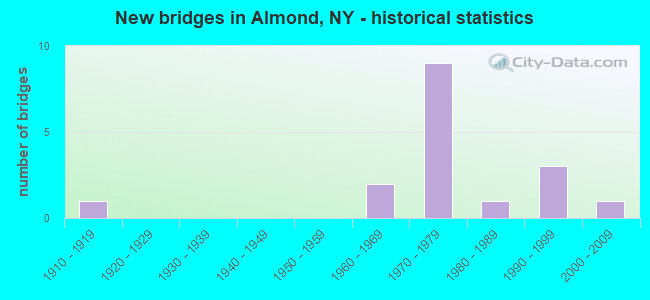
- New bridges - historical statistics
- 11910-1919
- 21960-1969
- 91970-1979
- 11980-1989
- 31990-1999
- 12000-2009

- Reconstructed bridges - Historical Statistics
- 11980-1989
- 31990-1999
- 42000-2009


- Bridge Condition - Deck
- 15.4%Excellent
- 15.4%Very good
- 53.8%Good
- 7.7%Satisfactory
- 7.7%Fair

- Bridge Condition - Superstructure
- 7.7%Excellent
- 7.7%Very good
- 23.1%Good
- 23.1%Satisfactory
- 15.4%Fair
- 23.1%Poor

- Bridge Condition - Substructure
- 7.7%Excellent
- 15.4%Very good
- 15.4%Good
- 46.2%Satisfactory
- 15.4%Fair

- Bridge Condition - Channel
- 8.3%Very good
- 16.7%Good
- 33.3%Satisfactory
- 41.7%Fair
Find on map >> Show street view
Structure Number: 101631, Location: RTE 21 S END ALMOND (Lat: 42.316236, Lng: -77.740717), Route carried "on" structure: State highway 21, Year Built: 1990, Status: Open, Structure Length: 5.39m (17.68ft), Average Daily Traffic: 5,535 (year 2020), Truck Traffic: 8%, Average Future Daily Traffic: 5,569 (year 2040), Design Load: HS 20, Features Intersected: KARR VALLEY CREEK
Minimum Vertical Clearance: 30+ m (98+ ft), Kilometerpoint: 19.388, Lanes on structure: 2, Owner: State Highway Agency, Approaching Roadway Width: 8.5m (27.9ft), Skew: 2 degrees, Material/Design: Prestressed concrete, Design/Construction: Box Beam or Girders - Multiple, Number Of Spans In Main Unit: 2, Length of Maximum Span: 26.5m (86.9ft), Curb or Sidewalk Widths: Left: 1.5m (4.9ft), Right: 1.5m (4.9ft), Curb-To-Curb Width: 8.5m (27.9ft), Out-to-Out Width: 12.4m (40.7ft)
Condition: Deck: Satisfactory, Superstructure: Fair, Substructure: Satisfactory, Channel: Satisfactory, Operating Rating: 76.2 metric tons, Method Used To Determine Operating Rating: Load Factor (LF), Inventory Rating: 45.4 metric tons, Method Used To Determine Inventory Rating: Load Factor (LF), Structural Evaluation: Somewhat better than minimum adequacy, Deck Geometry: High priority of replacement, Waterway Adequacy: Equal to present desirable criteria, Approach Roadway Alignment: Equal to present desirable criteria, Length Of Structure Improvement: 5.39m (17.68ft), Designated Inspection Frequency: Every 24 months, Inspection Date: April 2021, Bridge Improvement Cost: $1,653,000, Roadway Improvement Cost: $968,000, Total Project Cost: $2,622,000 ( Estimate for 2021), Wearing Surface/Protective System: Wearing Surface: Bituminous
Find on map >> Show street view
Structure Number: 1061641, Location: EXIT 33 OF I86 - ALMOND (Lat: 42.325178, Lng: -77.741222), Route carried "on" structure: Interstate 86, Year Built: 1973, Year Reconstructed: 2003, Status: Open, Structure Length: 3.87m (12.70ft), Average Daily Traffic: 3,615 (year 2014), Truck Traffic: 36%, Design Load: HS 20+Mod, Features Intersected: 962A 962A 61011004
Minimum Vertical Clearance: 30+ m (98+ ft), Kilometerpoint: 54.432, Lanes on structure: 3, Lanes under structure: 4, Base Highway Network: Yes, Owner: State Highway Agency, Approaching Roadway Width: 14.0m (45.9ft), Skew: 4 degrees, Material/Design: Steel, Design/Construction: Stringer/Multi-beam, Number Of Spans In Main Unit: 1, Length of Maximum Span: 36.8m (120.7ft), Curb-To-Curb Width: 14.5m (47.6ft), Out-to-Out Width: 15.4m (50.5ft)
Condition: Deck: Good, Superstructure: Good, Substructure: Fair, Operating Rating: 33.0 metric tons, Method Used To Determine Operating Rating: Load and Resistance Factor Rating (LRFR) rating reported by rating factor(RF) method using HL-93 loadings, Inventory Rating: 25.3 metric tons, Method Used To Determine Inventory Rating: Load and Resistance Factor Rating (LRFR) rating reported by rating factor(RF) method using HL-93 loadings, Structural Evaluation: Somewhat better than minimum adequacy, Deck Geometry: Meets minimum limits, Underclear: Meets minimum limits, Approach Roadway Alignment: Equal to present desirable criteria, Length Of Structure Improvement: 3.87m (12.70ft), Designated Inspection Frequency: Every 24 months, Inspection Date: July 2021, Bridge Improvement Cost: $2,614,000, Roadway Improvement Cost: $1,531,000, Total Project Cost: $4,145,000 ( Estimate for 2021), Deck Structure Type: Concrete Cast-file-Place, Wearing Surface/Protective System: Wearing Surface: Epoxy Overlay
Find on map >> Show street view
Structure Number: 1061642, Location: EXIT 33 OF I86 - ALMOND (Lat: 42.325236, Lng: -77.740603), Route carried "on" structure: Interstate 86, Year Built: 1973, Year Reconstructed: 2003, Status: Open, Structure Length: 3.47m (11.38ft), Average Daily Traffic: 3,460 (year 2020), Truck Traffic: 31%, Average Future Daily Traffic: 6,455 (year 2040), Design Load: HS 20+Mod, Features Intersected: 962A 962A 61011004
Minimum Vertical Clearance: 30+ m (98+ ft), Kilometerpoint: 54.432, Lanes on structure: 2, Lanes under structure: 4, Base Highway Network: Yes, Owner: State Highway Agency, Approaching Roadway Width: 12.2m (40.0ft), Skew: 3 degrees, Material/Design: Steel, Design/Construction: Stringer/Multi-beam, Number Of Spans In Main Unit: 1, Length of Maximum Span: 33.2m (108.9ft), Curb-To-Curb Width: 12.6m (41.3ft), Out-to-Out Width: 13.4m (44.0ft)
Condition: Deck: Good, Superstructure: Satisfactory, Substructure: Fair, Operating Rating: 54.8 metric tons, Method Used To Determine Operating Rating: Load and Resistance Factor Rating (LRFR) rating reported by rating factor(RF) method using HL-93 loadings, Inventory Rating: 42.1 metric tons, Method Used To Determine Inventory Rating: Load and Resistance Factor Rating (LRFR) rating reported by rating factor(RF) method using HL-93 loadings, Structural Evaluation: Somewhat better than minimum adequacy, Deck Geometry: Better than present minimum criteria, Underclear: Meets minimum limits, Approach Roadway Alignment: Equal to present desirable criteria, Length Of Structure Improvement: 3.47m (11.38ft), Designated Inspection Frequency: Every 24 months, Inspection Date: July 2021, Bridge Improvement Cost: $1,935,000, Roadway Improvement Cost: $1,133,000, Total Project Cost: $3,069,000 ( Estimate for 2021), Deck Structure Type: Concrete Cast-file-Place, Wearing Surface/Protective System: Wearing Surface: Epoxy Overlay
Find on map >> Show street view
Structure Number: 109027, Location: 1.1 MI SW OF ALMOND (Lat: 42.314769, Lng: -77.757139), Route carried "on" structure: Interstate 86, Year Built: 1973, Status: Open, Structure Length: 0.98m (3.22ft), Average Daily Traffic: 4,738 (year 2018), Truck Traffic: 31%, Average Future Daily Traffic: 8,839 (year 2040), Design Load: HS 20+Mod, Features Intersected: KARR VALLEY CRK
Minimum Vertical Clearance: 30+ m (98+ ft), Kilometerpoint: 52.566, Lanes on structure: 4, Base Highway Network: Yes, Owner: State Highway Agency, Approaching Roadway Width: 24.4m (80.1ft), Skew: 22 degrees, Material/Design: Concrete, Design/Construction: Culvert, Number Of Spans In Main Unit: 2, Length of Maximum Span: 4.0m (13.1ft)
Condition: Channel: Fair, Culverts: Satisfactory, Operating Rating: 54.4 metric tons, Method Used To Determine Operating Rating: Load Factor (LF), Inventory Rating: 32.7 metric tons, Method Used To Determine Inventory Rating: Load Factor (LF), Structural Evaluation: Equal to present minimum criteria, Waterway Adequacy: Meets minimum limits, Approach Roadway Alignment: Equal to present desirable criteria, Length Of Structure Improvement: 0.97m (3.18ft), Designated Inspection Frequency: Every 24 months, Inspection Date: July 2020, Bridge Improvement Cost: $516,000, Roadway Improvement Cost: $302,000, Total Project Cost: $819,000 ( Estimate for 2021), Wearing Surface/Protective System: Wearing Surface: Bituminous
Find on map >> Show street view
Structure Number: 221381, Location: IN BISHOPVILLE (Lat: 42.369117, Lng: -77.747467), Route carried "on" structure: Other road , Year Built: 1969, Year Reconstructed: 1994, Status: Posted for load, Structure Length: 0.94m (3.08ft), Average Daily Traffic: 57 (year 2018), Average Future Daily Traffic: 80 (year 2038), Features Intersected: TRIB CANISTEO RIV, Facility Carried by Structure: BISHOPVILLE EXT
Minimum Vertical Clearance: 30+ m (98+ ft), Kilometerpoint: 0.016, Lanes on structure: 2, Owner: Town or Township Highway Agency, Approaching Roadway Width: 6.1m (20.0ft), Skew: 1 degrees, Material/Design: Steel, Design/Construction: Stringer/Multi-beam, Number Of Spans In Main Unit: 1, Length of Maximum Span: 9.1m (29.9ft), Curb-To-Curb Width: 6.4m (21.0ft), Out-to-Out Width: 6.6m (21.7ft)
Condition: Deck: Good, Superstructure: Poor, Substructure: Satisfactory, Channel: Fair, Operating Rating: 41.7 metric tons, Method Used To Determine Operating Rating: Load Factor (LF), Inventory Rating: 24.5 metric tons, Method Used To Determine Inventory Rating: Load Factor (LF), Structural Evaluation: Meets minimum limits, Deck Geometry: Somewhat better than minimum adequacy, Waterway Adequacy: Equal to present desirable criteria, Approach Roadway Alignment: Meets minimum limits, Bridge Posting: Required (Relationship of Operating Rating to Maximum Legal Load: 20.0 - 29.9% below), Length Of Structure Improvement: 0.94m (3.08ft), Designated Inspection Frequency: Every 12 months, Inspection Date: May 2021, Bridge Improvement Cost: $289,000, Roadway Improvement Cost: $169,000, Total Project Cost: $459,000 ( Estimate for 2021), Deck Structure Type: Corrugated Steel, Wearing Surface/Protective System: Wearing Surface: Bituminous, Membrane: Other
Find on map >> Show street view
Structure Number: 221382, Location: 0.1 MI S OF BISHOPVILLE (Lat: 42.367394, Lng: -77.747764), Route carried "on" structure: Other road , Year Built: 1994, Status: Open, Structure Length: 0.94m (3.08ft), Average Daily Traffic: 270 (year 2018), Truck Traffic: 3%, Average Future Daily Traffic: 378 (year 2038), Design Load: HS 25 or greater, Features Intersected: TRIB CANISTEO RIV, Facility Carried by Structure: BISHOPVILLE ROAD
Minimum Vertical Clearance: 30+ m (98+ ft), Kilometerpoint: 5.535, Lanes on structure: 2, Owner: Town or Township Highway Agency, Approaching Roadway Width: 6.7m (22.0ft), Skew: 4 degrees, Material/Design: Wood or Timber, Design/Construction: Slab, Number Of Spans In Main Unit: 1, Length of Maximum Span: 8.2m (26.9ft), Curb-To-Curb Width: 7.3m (24.0ft), Out-to-Out Width: 7.9m (25.9ft)
Condition: Deck: Good, Superstructure: Good, Substructure: Good, Channel: Fair, Operating Rating: 78.4 metric tons, Method Used To Determine Operating Rating: Field evaluation and documented engineering judgment, Inventory Rating: 40.8 metric tons, Method Used To Determine Inventory Rating: Field evaluation and documented engineering judgment, Structural Evaluation: Better than present minimum criteria, Deck Geometry: Somewhat better than minimum adequacy, Waterway Adequacy: Equal to present desirable criteria, Approach Roadway Alignment: Equal to present minimum criteria, Length Of Structure Improvement: 0.94m (3.08ft), Designated Inspection Frequency: Every 24 months, Inspection Date: March 2020, Bridge Improvement Cost: $800,000, Roadway Improvement Cost: $468,000, Total Project Cost: $1,268,000 ( Estimate for 2021), Wearing Surface/Protective System: Wearing Surface: Bituminous, Membrane: Other
Find on map >> Show street view
Structure Number: 221391, Location: IN ALMOND (Lat: 42.317822, Lng: -77.737003), Route carried "on" structure: Other road , Year Built: 1973, Year Reconstructed: 2008, Status: Posted for load, Structure Length: 2.65m (8.69ft), Average Daily Traffic: 77 (year 2020), Truck Traffic: 5%, Average Future Daily Traffic: 108 (year 2040), Features Intersected: CANACADEA CREEK, Facility Carried by Structure: CANACADEA STREET
Minimum Vertical Clearance: 30+ m (98+ ft), Kilometerpoint: 0.161, Lanes on structure: 2, Owner: Town or Township Highway Agency, Approaching Roadway Width: 5.8m (19.0ft), Skew: 1 degrees, Material/Design: Steel, Design/Construction: Stringer/Multi-beam, Number Of Spans In Main Unit: 1, Length of Maximum Span: 24.9m (81.7ft), Curb-To-Curb Width: 7.3m (24.0ft), Out-to-Out Width: 7.6m (24.9ft)
Condition: Deck: Good, Superstructure: Poor, Substructure: Satisfactory, Channel: Good, Operating Rating: 13.0 metric tons, Method Used To Determine Operating Rating: Load and Resistance Factor Rating (LRFR) rating reported by rating factor(RF) method using HL-93 loadings, Inventory Rating: 10.0 metric tons, Method Used To Determine Inventory Rating: Load and Resistance Factor Rating (LRFR) rating reported by rating factor(RF) method using HL-93 loadings, Structural Evaluation: High priority of corrective action, Deck Geometry: Equal to present minimum criteria, Waterway Adequacy: Equal to present desirable criteria, Approach Roadway Alignment: Meets minimum limits, Bridge Posting: Required (Relationship of Operating Rating to Maximum Legal Load: 30.0 - 39.9% below), Length Of Structure Improvement: 2.65m (8.69ft), Designated Inspection Frequency: Every 12 months, Inspection Date: September 2021, Bridge Improvement Cost: $780,000, Roadway Improvement Cost: $457,000, Total Project Cost: $1,237,000 ( Estimate for 2021), Deck Structure Type: Open Grating, Wearing Surface/Protective System: Wearing Surface: Other
Find on map >> Show street view
Structure Number: 221393, Location: 2.2 MI SE OF ALMOND (Lat: 42.297789, Lng: -77.761317), Route carried "on" structure: Other road , Year Built: 1973, Year Reconstructed: 2014, Status: Open, Structure Length: 1.55m (5.09ft), Average Daily Traffic: 1 (year 2018), Truck Traffic: 5%, Average Future Daily Traffic: 1 (year 2038), Features Intersected: MCHENRY VALLEY CK, Facility Carried by Structure: STEPHANS ROAD
Minimum Vertical Clearance: 30+ m (98+ ft), Kilometerpoint: 0.080, Lanes on structure: 1, Owner: Town or Township Highway Agency, Approaching Roadway Width: 3.7m (12.1ft), Skew: 1 degrees, Material/Design: Steel, Design/Construction: Stringer/Multi-beam, Number Of Spans In Main Unit: 1, Length of Maximum Span: 15.2m (49.9ft), Curb-To-Curb Width: 4.3m (14.1ft), Out-to-Out Width: 4.4m (14.4ft)
Condition: Deck: Excellent, Superstructure: Satisfactory, Substructure: Very good, Channel: Satisfactory, Operating Rating: 54.4 metric tons, Method Used To Determine Operating Rating: Load Factor (LF), Inventory Rating: 32.7 metric tons, Method Used To Determine Inventory Rating: Load Factor (LF), Structural Evaluation: Equal to present minimum criteria, Deck Geometry: Equal to present minimum criteria, Waterway Adequacy: Equal to present desirable criteria, Approach Roadway Alignment: Somewhat better than minimum adequacy, Length Of Structure Improvement: 1.55m (5.09ft), Designated Inspection Frequency: Every 24 months, Inspection Date: November 2020, Bridge Improvement Cost: $231,000, Roadway Improvement Cost: $135,000, Total Project Cost: $366,000 ( Estimate for 2021), Deck Structure Type: Wood or Timber, Wearing Surface/Protective System: Wearing Surface: Bituminous
Find on map >> Show street view
Structure Number: 221394, Location: 2.4 MI S OF ALMOND (Lat: 42.288867, Lng: -77.747833), Route carried "on" structure: Other road , Year Built: 1973, Year Reconstructed: 2006, Status: Open, Structure Length: 1.89m (6.20ft), Average Daily Traffic: 113 (year 2018), Truck Traffic: 2%, Average Future Daily Traffic: 158 (year 2038), Features Intersected: CANACADEA CREEK, Facility Carried by Structure: SATTERLEE HILL RD
Minimum Vertical Clearance: 30+ m (98+ ft), Kilometerpoint: 0.064, Lanes on structure: 2, Owner: Town or Township Highway Agency, Approaching Roadway Width: 6.1m (20.0ft), Material/Design: Steel, Design/Construction: Stringer/Multi-beam, Number Of Spans In Main Unit: 1, Length of Maximum Span: 18.2m (59.7ft), Curb-To-Curb Width: 7.1m (23.3ft), Out-to-Out Width: 7.3m (24.0ft)
Condition: Deck: Fair, Superstructure: Poor, Substructure: Satisfactory, Channel: Fair, Operating Rating: 49.9 metric tons, Method Used To Determine Operating Rating: Load Factor (LF), Inventory Rating: 29.9 metric tons, Method Used To Determine Inventory Rating: Load Factor (LF), Structural Evaluation: Meets minimum limits, Deck Geometry: Meets minimum limits, Waterway Adequacy: Superior to present desirable criteria, Approach Roadway Alignment: Equal to present desirable criteria, Length Of Structure Improvement: 1.88m (6.17ft), Designated Inspection Frequency: Every 24 months, Inspection Date: November 2020, Bridge Improvement Cost: $516,000, Roadway Improvement Cost: $302,000, Total Project Cost: $819,000 ( Estimate for 2021), Deck Structure Type: Corrugated Steel, Wearing Surface/Protective System: Wearing Surface: Bituminous
Find on map >> Show street view
Structure Number: 225469, Location: IN ALMOND (Lat: 42.319483, Lng: -77.736425), Route carried "on" structure: Other road , Year Built: 1973, Year Reconstructed: 2012, Status: Open, Structure Length: 2.62m (8.60ft), Average Daily Traffic: 24 (year 2018), Truck Traffic: 5%, Average Future Daily Traffic: 34 (year 2038), Features Intersected: CANACADEA CREEK, Facility Carried by Structure: ERIE AVENUE
Minimum Vertical Clearance: 30+ m (98+ ft), Kilometerpoint: 0.129, Lanes on structure: 2, Owner: Town or Township Highway Agency, Approaching Roadway Width: 5.8m (19.0ft), Skew: 1 degrees, Material/Design: Steel, Design/Construction: Stringer/Multi-beam, Number Of Spans In Main Unit: 1, Length of Maximum Span: 24.9m (81.7ft), Curb-To-Curb Width: 7.8m (25.6ft), Out-to-Out Width: 8.4m (27.6ft)
Condition: Deck: Excellent, Superstructure: Satisfactory, Substructure: Satisfactory, Channel: Satisfactory, Operating Rating: 20.1 metric tons, Method Used To Determine Operating Rating: Load and Resistance Factor Rating (LRFR) rating reported by rating factor(RF) method using HL-93 loadings, Inventory Rating: 15.6 metric tons, Method Used To Determine Inventory Rating: Load and Resistance Factor Rating (LRFR) rating reported by rating factor(RF) method using HL-93 loadings, Structural Evaluation: Meets minimum limits, Deck Geometry: Equal to present minimum criteria, Waterway Adequacy: Equal to present desirable criteria, Approach Roadway Alignment: Meets minimum limits, Length Of Structure Improvement: 2.62m (8.60ft), Designated Inspection Frequency: Every 24 months, Inspection Date: November 2020, Bridge Improvement Cost: $784,000, Roadway Improvement Cost: $459,000, Total Project Cost: $1,244,000 ( Estimate for 2021), Deck Structure Type: Wood or Timber, Wearing Surface/Protective System: Wearing Surface: Bituminous, Membrane: Other
Find on map >> Show street view
Structure Number: 225599, Location: 1.4 MI W OF BISHOPVILLE (Lat: 42.374239, Lng: -77.777494), Route carried "on" structure: Other road , Year Built: 1983, Status: Open, Structure Length: 1.22m (4.00ft), Average Daily Traffic: 88 (year 2018), Truck Traffic: 5%, Average Future Daily Traffic: 123 (year 2038), Design Load: HS 20, Features Intersected: TRIB CANISTEO RVR, Facility Carried by Structure: BROWN ROAD
Minimum Vertical Clearance: 30+ m (98+ ft), Kilometerpoint: 0.965, Lanes on structure: 2, Owner: Town or Township Highway Agency, Approaching Roadway Width: 5.5m (18.0ft), Skew: 2 degrees, Material/Design: Steel, Design/Construction: Stringer/Multi-beam, Number Of Spans In Main Unit: 1, Length of Maximum Span: 11.2m (36.7ft), Curb-To-Curb Width: 7.1m (23.3ft), Out-to-Out Width: 7.3m (24.0ft)
Condition: Deck: Good, Superstructure: Fair, Substructure: Satisfactory, Channel: Fair, Operating Rating: 61.7 metric tons, Method Used To Determine Operating Rating: Load Factor (LF), Inventory Rating: 37.2 metric tons, Method Used To Determine Inventory Rating: Load Factor (LF), Structural Evaluation: Somewhat better than minimum adequacy, Deck Geometry: Somewhat better than minimum adequacy, Waterway Adequacy: Better than present minimum criteria, Approach Roadway Alignment: Equal to present desirable criteria, Length Of Structure Improvement: 1.21m (3.97ft), Designated Inspection Frequency: Every 24 months, Inspection Date: July 2020, Bridge Improvement Cost: $248,000, Roadway Improvement Cost: $145,000, Total Project Cost: $393,000 ( Estimate for 2021), Deck Structure Type: Corrugated Steel, Wearing Surface/Protective System: Wearing Surface: Bituminous, Membrane: Other
Find on map >> Show street view
Structure Number: 332983, Location: 1.0 MI SW OF ALMOND (Lat: 42.309081, Lng: -77.753189), Route carried "on" structure: County highway , Year Built: 1991, Status: Open, Structure Length: 4.42m (14.50ft), Average Daily Traffic: 780 (year 2018), Truck Traffic: 6%, Average Future Daily Traffic: 813 (year 2040), Design Load: HS 20, Features Intersected: MCHENRY VALLEY CR, Facility Carried by Structure: COUNTY ROAD 11
Minimum Vertical Clearance: 30+ m (98+ ft), Kilometerpoint: 10.282, Lanes on structure: 2, Owner: County Highway Agency, Approaching Roadway Width: 9.8m (32.2ft), Material/Design: Steel, Design/Construction: Stringer/Multi-beam, Number Of Spans In Main Unit: 1, Length of Maximum Span: 43.5m (142.7ft), Curb-To-Curb Width: 9.8m (32.2ft), Out-to-Out Width: 10.4m (34.1ft)
Condition: Deck: Very good, Superstructure: Excellent, Substructure: Excellent, Channel: Very good, Operating Rating: 79.8 metric tons, Method Used To Determine Operating Rating: Load Factor (LF), Inventory Rating: 40.8 metric tons, Method Used To Determine Inventory Rating: Load Factor (LF), Structural Evaluation: Superior to present desirable criteria, Deck Geometry: Equal to present minimum criteria, Waterway Adequacy: Equal to present desirable criteria, Approach Roadway Alignment: Equal to present desirable criteria, Length Of Structure Improvement: 4.41m (14.47ft), Designated Inspection Frequency: Every 24 months, Inspection Date: March 2020, Bridge Improvement Cost: $1,341,000, Roadway Improvement Cost: $785,000, Total Project Cost: $2,127,000 ( Estimate for 2021), Deck Structure Type: Concrete Cast-file-Place, Wearing Surface/Protective System: Wearing Surface: Bituminous, Deck Protection: Epoxy Coated Reinforcing
Find on map >> Show street view
Structure Number: 332985, Location: 3.0 MI W OF ALMOND (Lat: 42.320378, Lng: -77.793197), Route carried "on" structure: County highway , Year Built: 1967, Year Reconstructed: 2001, Status: Open, Structure Length: 1.07m (3.51ft), Average Daily Traffic: 225 (year 2019), Truck Traffic: 7%, Average Future Daily Traffic: 315 (year 2039), Design Load: HS 25 or greater, Features Intersected: TRIB KARR VLY CRK, Facility Carried by Structure: KARR VLY ROAD
Minimum Vertical Clearance: 30+ m (98+ ft), Kilometerpoint: 17.860, Lanes on structure: 2, Owner: County Highway Agency, Approaching Roadway Width: 6.4m (21.0ft), Skew: 1 degrees, Material/Design: Wood or Timber, Design/Construction: Slab, Number Of Spans In Main Unit: 1, Length of Maximum Span: 10.0m (32.8ft), Curb-To-Curb Width: 9.0m (29.5ft), Out-to-Out Width: 9.8m (32.2ft)
Condition: Deck: Good, Superstructure: Good, Substructure: Good, Channel: Satisfactory, Operating Rating: 79.7 metric tons, Method Used To Determine Operating Rating: Field evaluation and documented engineering judgment, Inventory Rating: 40.8 metric tons, Method Used To Determine Inventory Rating: Field evaluation and documented engineering judgment, Structural Evaluation: Better than present minimum criteria, Deck Geometry: Equal to present minimum criteria, Waterway Adequacy: Better than present minimum criteria, Approach Roadway Alignment: Equal to present desirable criteria, Length Of Structure Improvement: 1.06m (3.48ft), Designated Inspection Frequency: Every 24 months, Inspection Date: March 2021, Bridge Improvement Cost: $477,000, Roadway Improvement Cost: $279,000, Total Project Cost: $756,000 ( Estimate for 2021), Wearing Surface/Protective System: Wearing Surface: Bituminous, Membrane: Other
Find on map >> Show street view
Structure Number: 332988, Location: 3.7 MILES NW OF ALMOND (Lat: 42.366347, Lng: -77.775044), Route carried "on" structure: County highway , Year Built: 2009, Status: Open, Structure Length: 1.25m (4.10ft), Average Daily Traffic: 563 (year 2018), Truck Traffic: 4%, Average Future Daily Traffic: 788 (year 2038), Design Load: HS 25 or greater, Features Intersected: TRIB CANISTEO RVR, Facility Carried by Structure: COUNTY ROAD 32
Minimum Vertical Clearance: 30+ m (98+ ft), Kilometerpoint: 6.677, Lanes on structure: 2, Owner: County Highway Agency, Approaching Roadway Width: 6.1m (20.0ft), Skew: 2 degrees, Material/Design: Wood or Timber, Design/Construction: Slab, Number Of Spans In Main Unit: 1, Length of Maximum Span: 12.2m (40.0ft), Curb-To-Curb Width: 9.1m (29.9ft), Out-to-Out Width: 9.8m (32.2ft)
Condition: Deck: Very good, Superstructure: Very good, Substructure: Very good, Channel: Good, Operating Rating: 81.6 metric tons, Method Used To Determine Operating Rating: Allowable Stress (AS), Inventory Rating: 57.2 metric tons, Method Used To Determine Inventory Rating: Allowable Stress (AS), Structural Evaluation: Equal to present desirable criteria, Deck Geometry: Equal to present minimum criteria, Waterway Adequacy: Somewhat better than minimum adequacy, Approach Roadway Alignment: Equal to present desirable criteria, Length Of Structure Improvement: 1.24m (4.07ft), Designated Inspection Frequency: Every 24 months, Inspection Date: March 2021, Bridge Improvement Cost: $394,000, Roadway Improvement Cost: $231,000, Total Project Cost: $625,000 ( Estimate for 2021), Wearing Surface/Protective System: Wearing Surface: Bituminous, Membrane: Other
Find on map >> Show street view
Structure Number: 1061641, Location: EXIT 33 OF I86 - ALMOND (Lat: 42.325178, Lng: -77.741222), Route carried "under" structure: Alternate State highway , Year Built: 1973, Structure Length: 0. m, Average Daily Traffic: 2,800 (year 2021), Features Intersected: 962A 962A 61011004, Facility Carried by Structure: RTE I86
Minimum Vertical Clearance: 4.95m (16.24ft), Kilometerpoint: 0.354, Lanes on structure: 3, Lanes under structure: 4, Material/Design: Steel, Design/Construction: Stringer/Multi-beam, Length of Maximum Span: 36.8m (120.7ft)
Find on map >> Show street view
Structure Number: 1061642, Location: EXIT 33 OF I86 - ALMOND (Lat: 42.325236, Lng: -77.740603), Route carried "under" structure: Alternate State highway , Year Built: 1973, Structure Length: 0. m, Average Daily Traffic: 2,800 (year 2021), Features Intersected: 962A 962A 61011004, Facility Carried by Structure: RTE I86
Minimum Vertical Clearance: 4.78m (15.68ft), Kilometerpoint: 0.338, Lanes on structure: 2, Lanes under structure: 4, Material/Design: Steel, Design/Construction: Stringer/Multi-beam, Length of Maximum Span: 33.2m (108.9ft)
Find on map >> Show street view
Structure Number: 77008, Location: 2.5 MI S OF ALMOND (Lat: 42.288531, Lng: -77.745567), Route carried "under" structure: ServiceOther road , Year Built: 1912, Structure Length: 0. m, Average Daily Traffic: 113 (year 2018), Truck Traffic: 2%, Features Intersected: SATELEY HILL RD, Facility Carried by Structure: WNYP
Minimum Vertical Clearance: 7.11m (23.33ft), Kilometerpoint: 0.064, Lanes under structure: 2, Material/Design: Steel, Design/Construction: Girder and Floorbeam System, Length of Maximum Span: 13.4m (44.0ft)