Bridge Statistics for Aliceville, Alabama (AL)
Condition, Traffic, Stress, Structural Evaluation, Project Costs
- National Bridge Inventory (NBI) Statistics
- 27Number of bridges
- 384ft / 117mTotal length
- $36,946,000Total costs
- 31,458Total average daily traffic
- 3,542Total average daily truck traffic
- 45,532Total future (year 2028) average daily traffic
- National Bridge Inventory (NBI) Registered Bridges for Aliceville
- No street view available for this location
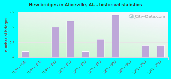
- New bridges - historical statistics
- 11920-1929
- 51940-1949
- 61950-1959
- 11960-1969
- 31970-1979
- 71980-1989
- 22000-2009
- 22010-2019

- Reconstructed bridges - Historical Statistics
- 11970-1979
- 21980-1989


- Bridge Condition - Deck
- 11.8%Very good
- 11.8%Good
- 76.5%Satisfactory

- Bridge Condition - Superstructure
- 11.8%Very good
- 35.3%Good
- 35.3%Satisfactory
- 11.8%Fair
- 5.9%Poor

- Bridge Condition - Substructure
- 11.8%Very good
- 35.3%Good
- 29.4%Satisfactory
- 23.5%Fair

- Bridge Condition - Channel
- 3.8%Excellent
- 15.4%Very good
- 34.6%Good
- 26.9%Satisfactory
- 19.2%Fair

- Bridge Condition - Culverts
- 10.0%Excellent
- 10.0%Very good
- 30.0%Good
- 50.0%Satisfactory
Find on map >> Show street view
Structure Number: 169, Location: 2.5 MI N JCT SR 14 (Lat: 33.164983, Lng: -88.110367), Route carried "on" structure: State highway 17, Year Built: 1926, Year Reconstructed: 1982, Status: Open, Structure Length: 1.10m (3.61ft), Average Daily Traffic: 3,429 (year 2020), Truck Traffic: 7%, Average Future Daily Traffic: 3,224 (year 2040), Design Load: H 15, Features Intersected: Trib. of Lubbub Creek
Minimum Vertical Clearance: 30+ m (98+ ft), Kilometerpoint: 310.861, Lanes on structure: 2, Base Highway Network: Yes, Owner: State Highway Agency, Approaching Roadway Width: 9.1m (29.9ft), Skew: 3 degrees, Material/Design: Concrete, Design/Construction: Culvert, Number Of Spans In Main Unit: 3, Length of Maximum Span: 3.5m (11.5ft)
Condition: Channel: Satisfactory, Culverts: Satisfactory, Operating Rating: 88.9 metric tons, Method Used To Determine Operating Rating: Load Factor (LF), Inventory Rating: 65.4 metric tons, Method Used To Determine Inventory Rating: Load Factor (LF), Structural Evaluation: Equal to present minimum criteria, Waterway Adequacy: Equal to present minimum criteria, Approach Roadway Alignment: Equal to present desirable criteria, Length Of Structure Improvement: 1.77m (5.81ft), Designated Inspection Frequency: Every 24 months, Inspection Date: Febuary 2022, Bridge Improvement Cost: $490,000, Roadway Improvement Cost: $49,000, Total Project Cost: $539,000 ( Estimate for 2022)
Find on map >> Show street view
Structure Number: 2672, Location: 1.5 MI E ALICEVILLE (Lat: 33.102764, Lng: -88.141033), Route carried "on" structure: State highway 14, Year Built: 1942, Status: Open, Structure Length: 14.39m (47.21ft), Average Daily Traffic: 1,083 (year 2020), Truck Traffic: 13%, Average Future Daily Traffic: 1,482 (year 2033), Design Load: H 15, Features Intersected: Lubub Creek
Minimum Vertical Clearance: 30+ m (98+ ft), Kilometerpoint: 34.236, Lanes on structure: 2, Base Highway Network: Yes, Owner: State Highway Agency, Approaching Roadway Width: 9.8m (32.2ft), Material/Design: Concrete, Design/Construction: Tee Beam, Number Of Spans In Main Unit: 3, Number Of Approach Spans: 10, Length of Maximum Span: 13.4m (44.0ft), Curb or Sidewalk Widths: Left: 0.5m (1.6ft), Right: 0.5m (1.6ft), Curb-To-Curb Width: 7.8m (25.6ft), Out-to-Out Width: 9.5m (31.2ft)
Condition: Deck: Satisfactory, Superstructure: Satisfactory, Substructure: Satisfactory, Channel: Satisfactory, Operating Rating: 40.5 metric tons, Method Used To Determine Operating Rating: Load Testing, Inventory Rating: 22.2 metric tons, Method Used To Determine Inventory Rating: Load Testing, Structural Evaluation: Somewhat better than minimum adequacy, Deck Geometry: Meets minimum limits, Waterway Adequacy: Equal to present minimum criteria, Approach Roadway Alignment: Equal to present minimum criteria, Length Of Structure Improvement: 15.17m (49.77ft), Designated Inspection Frequency: Every 24 months, Underwater Inspection Frequency: Every 24 months, Inspection Date: November 2020, Underwater Inspection Date: July 2020, Bridge Improvement Cost: $3,226,000, Roadway Improvement Cost: $323,000, Total Project Cost: $3,549,000 ( Estimate for 2022), Deck Structure Type: Concrete Cast-file-Place
Find on map >> Show street view
Structure Number: 2673, Location: 2.5 MI E ALICEVILLE (Lat: 33.096033, Lng: -88.136200), Route carried "on" structure: State highway 14, Year Built: 1942, Status: Open, Structure Length: 1.16m (3.81ft), Average Daily Traffic: 1,083 (year 2020), Truck Traffic: 13%, Average Future Daily Traffic: 1,482 (year 2041), Design Load: H 15, Features Intersected: Lubub Creek Branch
Minimum Vertical Clearance: 30+ m (98+ ft), Kilometerpoint: 35.486, Lanes on structure: 2, Base Highway Network: Yes, Owner: State Highway Agency, Approaching Roadway Width: 10.7m (35.1ft), Skew: 3 degrees, Material/Design: Concrete, Design/Construction: Culvert, Number Of Spans In Main Unit: 5, Length of Maximum Span: 2.1m (6.9ft)
Condition: Channel: Satisfactory, Culverts: Satisfactory, Operating Rating: 32.7 metric tons, Method Used To Determine Operating Rating: Field evaluation and documented engineering judgment, Inventory Rating: 23.6 metric tons, Method Used To Determine Inventory Rating: Field evaluation and documented engineering judgment, Structural Evaluation: Equal to present minimum criteria, Waterway Adequacy: Equal to present minimum criteria, Approach Roadway Alignment: Better than present minimum criteria, Length Of Structure Improvement: 1.83m (6.00ft), Designated Inspection Frequency: Every 24 months, Inspection Date: November 2021, Bridge Improvement Cost: $476,000, Roadway Improvement Cost: $48,000, Total Project Cost: $524,000 ( Estimate for 2022)
Find on map >> Show street view
Structure Number: 2674, Location: 2.8 MI E ALICEVILLE (Lat: 33.092667, Lng: -88.134200), Route carried "on" structure: State highway 14, Year Built: 1942, Year Reconstructed: 1985, Status: Open, Structure Length: 0.79m (2.59ft), Average Daily Traffic: 1,083 (year 2020), Truck Traffic: 13%, Average Future Daily Traffic: 1,482 (year 2041), Design Load: H 15, Features Intersected: Lubbub Creek Branch
Minimum Vertical Clearance: 30+ m (98+ ft), Kilometerpoint: 35.592, Lanes on structure: 2, Base Highway Network: Yes, Owner: State Highway Agency, Approaching Roadway Width: 10.7m (35.1ft), Material/Design: Concrete, Design/Construction: Culvert, Number Of Spans In Main Unit: 4, Length of Maximum Span: 1.8m (5.9ft)
Condition: Channel: Satisfactory, Culverts: Good, Operating Rating: 88.9 metric tons, Method Used To Determine Operating Rating: Load Factor (LF), Inventory Rating: 88.9 metric tons, Method Used To Determine Inventory Rating: Load Factor (LF), Structural Evaluation: Better than present minimum criteria, Waterway Adequacy: Equal to present minimum criteria, Approach Roadway Alignment: Equal to present minimum criteria, Length Of Structure Improvement: 1.45m (4.76ft), Designated Inspection Frequency: Every 24 months, Inspection Date: November 2021, Bridge Improvement Cost: $368,000, Roadway Improvement Cost: $37,000, Total Project Cost: $405,000 ( Estimate for 2022)
Find on map >> Show street view
Structure Number: 2675, Location: 1.0 MI W GREENE CO LINE (Lat: 33.052917, Lng: -88.122433), Route carried "on" structure: State highway 14, Year Built: 1942, Status: Open, Structure Length: 0.73m (2.40ft), Average Daily Traffic: 1,220 (year 2020), Truck Traffic: 15%, Average Future Daily Traffic: 1,643 (year 2041), Design Load: H 15, Features Intersected: Lubbub Creek Branch
Minimum Vertical Clearance: 30+ m (98+ ft), Kilometerpoint: 40.383, Lanes on structure: 2, Base Highway Network: Yes, Owner: State Highway Agency, Approaching Roadway Width: 10.1m (33.1ft), Skew: 3 degrees, Material/Design: Concrete, Design/Construction: Culvert, Number Of Spans In Main Unit: 2, Length of Maximum Span: 3.5m (11.5ft)
Condition: Channel: Fair, Culverts: Good, Operating Rating: 88.9 metric tons, Method Used To Determine Operating Rating: Load Factor (LF), Inventory Rating: 69.9 metric tons, Method Used To Determine Inventory Rating: Load Factor (LF), Structural Evaluation: Better than present minimum criteria, Waterway Adequacy: Somewhat better than minimum adequacy, Approach Roadway Alignment: Better than present minimum criteria, Length Of Structure Improvement: 1.38m (4.53ft), Designated Inspection Frequency: Every 24 months, Inspection Date: November 2021, Bridge Improvement Cost: $350,000, Roadway Improvement Cost: $35,000, Total Project Cost: $385,000 ( Estimate for 2022)
Find on map >> Show street view
Structure Number: 3187, Location: 3.2 MI EAST OF ST RT 14 (Lat: 33.116811, Lng: -88.085431), Route carried "on" structure: County highway 2, Year Built: 1948, Status: Open, Structure Length: 0.76m (2.49ft), Average Daily Traffic: 600 (year 1998), Truck Traffic: 10%, Average Future Daily Traffic: 650 (year 2032), Design Load: H 15, Features Intersected: STERING LAKE BRANCH
Minimum Vertical Clearance: 30+ m (98+ ft), Kilometerpoint: 0.010, Lanes on structure: 2, Owner: County Highway Agency, Approaching Roadway Width: 7.9m (25.9ft), Skew: 4 degrees, Material/Design: Concrete, Design/Construction: Culvert, Number Of Spans In Main Unit: 2, Length of Maximum Span: 2.4m (7.9ft), Curb-To-Curb Width: 7.4m (24.3ft), Out-to-Out Width: 7.9m (25.9ft)
Condition: Channel: Good, Culverts: Good, Operating Rating: 47.4 metric tons, Method Used To Determine Operating Rating: Load Factor (LF), Inventory Rating: 28.2 metric tons, Method Used To Determine Inventory Rating: Load Factor (LF), Structural Evaluation: Better than present minimum criteria, Deck Geometry: Meets minimum limits, Waterway Adequacy: Equal to present desirable criteria, Approach Roadway Alignment: Better than present minimum criteria, Length Of Structure Improvement: 1.41m (4.63ft), Designated Inspection Frequency: Every 24 months, Inspection Date: December 2020, Bridge Improvement Cost: $293,000, Roadway Improvement Cost: $29,000, Total Project Cost: $322,000 ( Estimate for 2022)
Find on map >> Show street view
Structure Number: 3676, Location: 4.5 MI NW OF SR17 (Lat: 33.176000, Lng: -88.205900), Route carried "on" structure: State highway 14, Year Built: 1950, Status: Open, Structure Length: 4.57m (14.99ft), Average Daily Traffic: 1,676 (year 2020), Truck Traffic: 7%, Average Future Daily Traffic: 2,155 (year 2040), Design Load: H 15, Features Intersected: Beaver Creek
Minimum Vertical Clearance: 30+ m (98+ ft), Kilometerpoint: 23.533, Lanes on structure: 2, Base Highway Network: Yes, Owner: State Highway Agency, Approaching Roadway Width: 8.5m (27.9ft), Material/Design: Steel, Design/Construction: Stringer/Multi-beam, Number Of Spans In Main Unit: 5, Length of Maximum Span: 9.1m (29.9ft), Curb or Sidewalk Widths: Left: 0.5m (1.6ft), Right: 0.5m (1.6ft), Curb-To-Curb Width: 7.3m (24.0ft), Out-to-Out Width: 8.9m (29.2ft)
Condition: Deck: Satisfactory, Superstructure: Fair, Substructure: Good, Channel: Satisfactory, Operating Rating: 68.8 metric tons, Method Used To Determine Operating Rating: Load Testing, Inventory Rating: 47.1 metric tons, Method Used To Determine Inventory Rating: Load Testing, Structural Evaluation: Somewhat better than minimum adequacy, Deck Geometry: Meets minimum limits, Waterway Adequacy: Equal to present minimum criteria, Approach Roadway Alignment: Equal to present desirable criteria, Length Of Structure Improvement: 5.57m (18.27ft), Designated Inspection Frequency: Every 24 months, Inspection Date: Febuary 2022, Bridge Improvement Cost: $1,107,000, Roadway Improvement Cost: $111,000, Total Project Cost: $1,218,000 ( Estimate for 2022), Deck Structure Type: Concrete Cast-file-Place
Find on map >> Show street view
Structure Number: 3677, Location: 2.0 MI W ALICEVILLE (Lat: 33.147347, Lng: -88.170536), Route carried "on" structure: State highway 14, Year Built: 1950, Status: Closed, Structure Length: 8.29m (27.20ft), Average Daily Traffic: 2,871 (year 2020), Truck Traffic: 14%, Average Future Daily Traffic: 3,879 (year 2041), Design Load: H 15, Features Intersected: Blubber Creek
Minimum Vertical Clearance: 30+ m (98+ ft), Kilometerpoint: 28.133, Lanes on structure: 2, Base Highway Network: Yes, Owner: State Highway Agency, Approaching Roadway Width: 8.5m (27.9ft), Material/Design: Steel, Design/Construction: Stringer/Multi-beam, Number Of Spans In Main Unit: 8, Length of Maximum Span: 10.4m (34.1ft), Curb or Sidewalk Widths: Left: 0.5m (1.6ft), Right: 0.5m (1.6ft), Curb-To-Curb Width: 7.3m (24.0ft), Out-to-Out Width: 8.9m (29.2ft)
Condition: Deck: Satisfactory, Superstructure: Poor, Substructure: Satisfactory, Channel: Satisfactory, Waterway Adequacy: Equal to present minimum criteria, Approach Roadway Alignment: Equal to present desirable criteria, Bridge Posting: Required (Relationship of Operating Rating to Maximum Legal Load: > 39.9% below), Length Of Structure Improvement: 9.29m (30.48ft), Designated Inspection Frequency: Every 24 months, Other Special Inspection Frequency: Every 12 months, Inspection Date: Febuary 2021, Other Special Inspection Date: Febuary 2021, Bridge Improvement Cost: $1,847,000, Roadway Improvement Cost: $185,000, Total Project Cost: $2,032,000 ( Estimate for 2020), Deck Structure Type: Concrete Cast-file-Place
Find on map >> Show street view
Structure Number: 3678, Location: 1.0 MI W ALICEVILLE (Lat: 33.140878, Lng: -88.163342), Route carried "on" structure: State highway 14, Year Built: 1950, Status: Open, Structure Length: 1.01m (3.31ft), Average Daily Traffic: 2,880 (year 2013), Truck Traffic: 9%, Average Future Daily Traffic: 3,879 (year 2041), Design Load: H 15, Features Intersected: Blubber Creek Branch
Minimum Vertical Clearance: 30+ m (98+ ft), Kilometerpoint: 29.185, Lanes on structure: 2, Base Highway Network: Yes, Owner: State Highway Agency, Approaching Roadway Width: 9.4m (30.8ft), Material/Design: Concrete, Design/Construction: Culvert, Number Of Spans In Main Unit: 3, Length of Maximum Span: 3.0m (9.8ft)
Condition: Channel: Fair, Culverts: Satisfactory, Operating Rating: 88.9 metric tons, Method Used To Determine Operating Rating: Load Factor (LF), Inventory Rating: 64.8 metric tons, Method Used To Determine Inventory Rating: Load Factor (LF), Structural Evaluation: Equal to present minimum criteria, Waterway Adequacy: Equal to present minimum criteria, Approach Roadway Alignment: Better than present minimum criteria, Length Of Structure Improvement: 1.68m (5.51ft), Designated Inspection Frequency: Every 24 months, Inspection Date: November 2021, Bridge Improvement Cost: $348,000, Roadway Improvement Cost: $35,000, Total Project Cost: $383,000 ( Estimate for 2022)
Find on map >> Show street view
Structure Number: 3699, Location: 1.1 MI NORTH ST RT #14 (Lat: 33.165403, Lng: -88.170061), Route carried "on" structure: County highway 19, Year Built: 1950, Status: Posted for load, Structure Length: 1.16m (3.81ft), Average Daily Traffic: 300 (year 1998), Truck Traffic: 10%, Average Future Daily Traffic: 350 (year 2034), Design Load: H 15, Features Intersected: BLUBBER CRK
Minimum Vertical Clearance: 30+ m (98+ ft), Kilometerpoint: 0.010, Lanes on structure: 2, Owner: County Highway Agency, Approaching Roadway Width: 8.5m (27.9ft), Material/Design: Concrete, Design/Construction: Channel Beam, Number Of Spans In Main Unit: 2, Length of Maximum Span: 5.8m (19.0ft), Curb-To-Curb Width: 6.7m (22.0ft), Out-to-Out Width: 7.3m (24.0ft)
Condition: Deck: Satisfactory, Superstructure: Fair, Substructure: Fair, Channel: Good, Operating Rating: 40.6 metric tons, Method Used To Determine Operating Rating: Load Factor (LF), Inventory Rating: 24.4 metric tons, Method Used To Determine Inventory Rating: Load Factor (LF), Structural Evaluation: Somewhat better than minimum adequacy, Deck Geometry: Meets minimum limits, Waterway Adequacy: Equal to present minimum criteria, Approach Roadway Alignment: Better than present minimum criteria, Bridge Posting: Required (Relationship of Operating Rating to Maximum Legal Load: 0.1 - 9.9% below), Length Of Structure Improvement: 1.84m (6.04ft), Designated Inspection Frequency: Every 24 months, Other Special Inspection Frequency: Every 12 months, Inspection Date: January 2022, Other Special Inspection Date: January 2022, Bridge Improvement Cost: $302,000, Roadway Improvement Cost: $30,000, Total Project Cost: $332,000 ( Estimate for 2022), Deck Structure Type: Concrete Precast Panels, Wearing Surface/Protective System: Wearing Surface: Bituminous
Find on map >> Show street view
Structure Number: 5196, Location: 2.5MI E OF SR 14 (Lat: 33.070644, Lng: -88.099253), Route carried "on" structure: County highway 23, Year Built: 1955, Status: Open, Structure Length: 1.52m (4.99ft), Average Daily Traffic: 550 (year 1998), Truck Traffic: 15%, Average Future Daily Traffic: 600 (year 2028), Design Load: HS 20, Features Intersected: HUGHES CREEK
Minimum Vertical Clearance: 30+ m (98+ ft), Kilometerpoint: 0.000, Lanes on structure: 2, Owner: County Highway Agency, Approaching Roadway Width: 9.8m (32.2ft), Material/Design: Concrete, Design/Construction: Culvert, Number Of Spans In Main Unit: 4, Length of Maximum Span: 3.7m (12.1ft)
Condition: Channel: Good, Culverts: Satisfactory, Operating Rating: 34.6 metric tons, Method Used To Determine Operating Rating: Load Factor (LF), Inventory Rating: 20.8 metric tons, Method Used To Determine Inventory Rating: Load Factor (LF), Structural Evaluation: Somewhat better than minimum adequacy, Waterway Adequacy: Better than present minimum criteria, Approach Roadway Alignment: Better than present minimum criteria, Length Of Structure Improvement: 2.20m (7.22ft), Designated Inspection Frequency: Every 24 months, Inspection Date: November 2021, Bridge Improvement Cost: $394,000, Roadway Improvement Cost: $39,000, Total Project Cost: $433,000 ( Estimate for 2022)
Find on map >> Show street view
Structure Number: 968, Location: 0.5 MILES E OF JCT SR 17 (Lat: 33.155625, Lng: -88.104531), Route carried "on" structure: County highway 24, Year Built: 1968, Status: Posted for load, Structure Length: 16.58m (54.40ft), Average Daily Traffic: 300 (year 1998), Truck Traffic: 3%, Average Future Daily Traffic: 325 (year 2034), Design Load: H 20, Features Intersected: LUBBUB CREEK
Minimum Vertical Clearance: 30+ m (98+ ft), Kilometerpoint: 0.000, Lanes on structure: 2, Owner: County Highway Agency, Approaching Roadway Width: 8.5m (27.9ft), Material/Design: Concrete, Design/Construction: Tee Beam, Number Of Spans In Main Unit: 16, Length of Maximum Span: 10.4m (34.1ft), Curb-To-Curb Width: 7.3m (24.0ft), Out-to-Out Width: 8.8m (28.9ft)
Condition: Deck: Good, Superstructure: Good, Substructure: Good, Channel: Good, Operating Rating: 39.6 metric tons, Method Used To Determine Operating Rating: Load Factor (LF), Inventory Rating: 23.8 metric tons, Method Used To Determine Inventory Rating: Load Factor (LF), Structural Evaluation: Equal to present minimum criteria, Deck Geometry: Somewhat better than minimum adequacy, Waterway Adequacy: Equal to present minimum criteria, Approach Roadway Alignment: Somewhat better than minimum adequacy, Bridge Posting: Required (Relationship of Operating Rating to Maximum Legal Load: 10.0 - 19.9% below), Length Of Structure Improvement: 17.32m (56.82ft), Designated Inspection Frequency: Every 24 months, Other Special Inspection Frequency: Every 12 months, Inspection Date: October 2021, Other Special Inspection Date: October 2021, Bridge Improvement Cost: $3,325,000, Roadway Improvement Cost: $333,000, Total Project Cost: $3,658,000 ( Estimate for 2022), Deck Structure Type: Concrete Cast-file-Place
Find on map >> Show street view
Structure Number: 1168, Location: 0.4MI E OF US HWY # 17 (Lat: 33.093339, Lng: -88.200922), Route carried "on" structure: County highway 67, Year Built: 1976, Status: Posted for load, Structure Length: 0.94m (3.08ft), Average Daily Traffic: 150 (year 1998), Truck Traffic: 30%, Average Future Daily Traffic: 200 (year 2034), Design Load: H 15, Features Intersected: HORTON BRANCH
Minimum Vertical Clearance: 30+ m (98+ ft), Kilometerpoint: 0.010, Lanes on structure: 2, Owner: County Highway Agency, Approaching Roadway Width: 7.3m (24.0ft), Material/Design: Wood or Timber, Design/Construction: Stringer/Multi-beam, Number Of Spans In Main Unit: 2, Length of Maximum Span: 4.6m (15.1ft), Curb-To-Curb Width: 6.7m (22.0ft), Out-to-Out Width: 6.7m (22.0ft)
Condition: Deck: Satisfactory, Superstructure: Satisfactory, Substructure: Satisfactory, Channel: Good, Operating Rating: 17.3 metric tons, Method Used To Determine Operating Rating: Allowable Stress (AS), Inventory Rating: 12.3 metric tons, Method Used To Determine Inventory Rating: Allowable Stress (AS), Structural Evaluation: Meets minimum limits, Deck Geometry: Meets minimum limits, Waterway Adequacy: Equal to present minimum criteria, Approach Roadway Alignment: Equal to present minimum criteria, Bridge Posting: Required (Relationship of Operating Rating to Maximum Legal Load: > 39.9% below), Length Of Structure Improvement: 1.61m (5.28ft), Designated Inspection Frequency: Every 24 months, Other Special Inspection Frequency: Every 12 months, Inspection Date: January 2022, Other Special Inspection Date: January 2022, Bridge Improvement Cost: $243,000, Roadway Improvement Cost: $24,000, Total Project Cost: $267,000 ( Estimate for 2022), Deck Structure Type: Concrete Cast-file-Place
Find on map >> Show street view
Structure Number: 11681, Location: .7 MILES EAST OF US#17 (Lat: 33.089550, Lng: -88.197014), Route carried "on" structure: County highway 67, Year Built: 1976, Status: Posted for load, Structure Length: 1.37m (4.49ft), Average Daily Traffic: 150 (year 1998), Truck Traffic: 30%, Average Future Daily Traffic: 200 (year 2034), Design Load: H 15, Features Intersected: BEAVER POND BRANCH
Minimum Vertical Clearance: 30+ m (98+ ft), Kilometerpoint: 0.010, Lanes on structure: 2, Owner: County Highway Agency, Approaching Roadway Width: 7.3m (24.0ft), Material/Design: Wood or Timber, Design/Construction: Stringer/Multi-beam, Number Of Spans In Main Unit: 3, Length of Maximum Span: 4.6m (15.1ft), Curb-To-Curb Width: 6.7m (22.0ft), Out-to-Out Width: 6.7m (22.0ft)
Condition: Deck: Satisfactory, Superstructure: Satisfactory, Substructure: Satisfactory, Channel: Good, Operating Rating: 17.1 metric tons, Method Used To Determine Operating Rating: Allowable Stress (AS), Inventory Rating: 12.1 metric tons, Method Used To Determine Inventory Rating: Allowable Stress (AS), Structural Evaluation: Meets minimum limits, Deck Geometry: Meets minimum limits, Waterway Adequacy: Equal to present minimum criteria, Approach Roadway Alignment: Equal to present minimum criteria, Bridge Posting: Required (Relationship of Operating Rating to Maximum Legal Load: > 39.9% below), Length Of Structure Improvement: 2.04m (6.69ft), Designated Inspection Frequency: Every 24 months, Other Special Inspection Frequency: Every 12 months, Inspection Date: January 2022, Other Special Inspection Date: January 2022, Bridge Improvement Cost: $308,000, Roadway Improvement Cost: $31,000, Total Project Cost: $339,000 ( Estimate for 2022), Deck Structure Type: Concrete Cast-file-Place
Find on map >> Show street view
Structure Number: 1187, Location: 1.5 MILES E CO RT #29 (Lat: 33.174519, Lng: -88.118936), Route carried "on" structure: County highway 201, Year Built: 1977, Status: Posted for load, Structure Length: 0.91m (2.99ft), Average Daily Traffic: 50 (year 1998), Average Future Daily Traffic: 75 (year 2034), Features Intersected: JENKINS CREEK
Minimum Vertical Clearance: 30+ m (98+ ft), Kilometerpoint: 0.010, Lanes on structure: 2, Owner: County Highway Agency, Approaching Roadway Width: 7.9m (25.9ft), Material/Design: Wood or Timber, Design/Construction: Stringer/Multi-beam, Number Of Spans In Main Unit: 2, Length of Maximum Span: 4.6m (15.1ft), Curb-To-Curb Width: 6.7m (22.0ft), Out-to-Out Width: 6.7m (22.0ft)
Condition: Deck: Satisfactory, Superstructure: Satisfactory, Substructure: Fair, Channel: Fair, Operating Rating: 22.2 metric tons, Method Used To Determine Operating Rating: Allowable Stress (AS), Inventory Rating: 11.5 metric tons, Method Used To Determine Inventory Rating: Allowable Stress (AS), Structural Evaluation: Meets minimum limits, Deck Geometry: Somewhat better than minimum adequacy, Waterway Adequacy: Equal to present minimum criteria, Approach Roadway Alignment: Equal to present minimum criteria, Bridge Posting: Required (Relationship of Operating Rating to Maximum Legal Load: 30.0 - 39.9% below), Length Of Structure Improvement: 1.58m (5.18ft), Designated Inspection Frequency: Every 24 months, Other Special Inspection Frequency: Every 12 months, Inspection Date: March 2020, Other Special Inspection Date: March 2021, Bridge Improvement Cost: $238,000, Roadway Improvement Cost: $24,000, Total Project Cost: $262,000 ( Estimate for 2022), Deck Structure Type: Concrete Cast-file-Place
Find on map >> Show street view
Structure Number: 12364, Location: 1.0 MI N TOMBIGBEE (Lat: 33.086583, Lng: -88.228233), Route carried "on" structure: State highway 17, Year Built: 1980, Status: Open, Structure Length: 6.22m (20.41ft), Average Daily Traffic: 1,524 (year 2020), Truck Traffic: 17%, Average Future Daily Traffic: 2,102 (year 2036), Design Load: HS 20, Features Intersected: Tombigbee River Relief
Minimum Vertical Clearance: 30+ m (98+ ft), Kilometerpoint: 295.302, Lanes on structure: 2, Base Highway Network: Yes, Owner: State Highway Agency, Approaching Roadway Width: 13.4m (44.0ft), Material/Design: Prestressed concrete continuous, Design/Construction: Stringer/Multi-beam, Number Of Spans In Main Unit: 6, Length of Maximum Span: 10.4m (34.1ft), Curb-To-Curb Width: 13.4m (44.0ft), Out-to-Out Width: 14.3m (46.9ft)
Condition: Deck: Satisfactory, Superstructure: Good, Substructure: Good, Channel: Very good, Operating Rating: 61.2 metric tons, Method Used To Determine Operating Rating: Load Factor (LF), Inventory Rating: 36.7 metric tons, Method Used To Determine Inventory Rating: Load Factor (LF), Structural Evaluation: Better than present minimum criteria, Deck Geometry: Equal to present desirable criteria, Waterway Adequacy: Equal to present minimum criteria, Approach Roadway Alignment: Equal to present desirable criteria, Length Of Structure Improvement: 7.26m (23.82ft), Designated Inspection Frequency: Every 24 months, Inspection Date: Febuary 2022, Bridge Improvement Cost: $2,289,000, Roadway Improvement Cost: $229,000, Total Project Cost: $2,518,000 ( Estimate for 2022), Deck Structure Type: Concrete Cast-file-Place
Find on map >> Show street view
Structure Number: 12365, Location: 1.5 MI N TOMBIGBEE RIVER (Lat: 33.085667, Lng: -88.215928), Route carried "on" structure: State highway 17, Year Built: 1980, Status: Open, Structure Length: 18.68m (61.29ft), Average Daily Traffic: 1,524 (year 2020), Truck Traffic: 17%, Average Future Daily Traffic: 2,102 (year 2033), Design Load: HS 20, Features Intersected: Blubber Creek
Minimum Vertical Clearance: 30+ m (98+ ft), Kilometerpoint: 296.298, Lanes on structure: 2, Base Highway Network: Yes, Owner: State Highway Agency, Approaching Roadway Width: 13.4m (44.0ft), Material/Design: Prestressed concrete continuous, Design/Construction: Stringer/Multi-beam, Number Of Spans In Main Unit: 18, Length of Maximum Span: 10.4m (34.1ft), Curb-To-Curb Width: 13.4m (44.0ft), Out-to-Out Width: 14.3m (46.9ft)
Condition: Deck: Good, Superstructure: Good, Substructure: Good, Channel: Good, Operating Rating: 61.2 metric tons, Method Used To Determine Operating Rating: Load Factor (LF), Inventory Rating: 36.7 metric tons, Method Used To Determine Inventory Rating: Load Factor (LF), Structural Evaluation: Better than present minimum criteria, Deck Geometry: Equal to present desirable criteria, Waterway Adequacy: Equal to present minimum criteria, Approach Roadway Alignment: Better than present minimum criteria, Length Of Structure Improvement: 19.32m (63.39ft), Designated Inspection Frequency: Every 24 months, Inspection Date: December 2020, Bridge Improvement Cost: $6,095,000, Roadway Improvement Cost: $610,000, Total Project Cost: $6,705,000 ( Estimate for 2022), Deck Structure Type: Concrete Cast-file-Place
Find on map >> Show street view
Structure Number: 12366, Location: 2.2 MI N TOMBIGBEE RIVER (Lat: 33.091261, Lng: -88.208133), Route carried "on" structure: State highway 17, Year Built: 1980, Status: Open, Structure Length: 10.36m (33.99ft), Average Daily Traffic: 1,524 (year 2020), Truck Traffic: 17%, Average Future Daily Traffic: 2,102 (year 2040), Design Load: HS 20, Features Intersected: Tombigbee River Relief
Minimum Vertical Clearance: 30+ m (98+ ft), Kilometerpoint: 297.301, Lanes on structure: 2, Base Highway Network: Yes, Owner: State Highway Agency, Approaching Roadway Width: 13.4m (44.0ft), Material/Design: Prestressed concrete continuous, Design/Construction: Stringer/Multi-beam, Number Of Spans In Main Unit: 10, Length of Maximum Span: 10.4m (34.1ft), Curb-To-Curb Width: 13.4m (44.0ft), Out-to-Out Width: 14.3m (46.9ft)
Condition: Deck: Satisfactory, Superstructure: Good, Substructure: Good, Channel: Very good, Operating Rating: 61.2 metric tons, Method Used To Determine Operating Rating: Field evaluation and documented engineering judgment, Inventory Rating: 36.7 metric tons, Method Used To Determine Inventory Rating: Load Factor (LF), Structural Evaluation: Better than present minimum criteria, Deck Geometry: Equal to present desirable criteria, Waterway Adequacy: Better than present minimum criteria, Approach Roadway Alignment: Better than present minimum criteria, Length Of Structure Improvement: 11.28m (37.01ft), Designated Inspection Frequency: Every 24 months, Inspection Date: Febuary 2022, Bridge Improvement Cost: $3,558,000, Roadway Improvement Cost: $356,000, Total Project Cost: $3,914,000 ( Estimate for 2022), Deck Structure Type: Concrete Cast-file-Place
Find on map >> Show street view
Structure Number: 12367, Location: 2.7 MI N TOMBIGBEE RIVER (Lat: 33.096350, Lng: -88.204767), Route carried "on" structure: State highway 17, Year Built: 1980, Status: Open, Structure Length: 8.29m (27.20ft), Average Daily Traffic: 1,524 (year 2020), Truck Traffic: 17%, Average Future Daily Traffic: 2,102 (year 2040), Design Load: HS 20, Features Intersected: Tombigbee River Relief
Minimum Vertical Clearance: 30+ m (98+ ft), Kilometerpoint: 298.125, Lanes on structure: 2, Base Highway Network: Yes, Owner: State Highway Agency, Approaching Roadway Width: 12.7m (41.7ft), Material/Design: Prestressed concrete continuous, Design/Construction: Stringer/Multi-beam, Number Of Spans In Main Unit: 8, Length of Maximum Span: 10.4m (34.1ft), Curb-To-Curb Width: 13.6m (44.6ft), Out-to-Out Width: 14.3m (46.9ft)
Condition: Deck: Satisfactory, Superstructure: Good, Substructure: Good, Channel: Good, Operating Rating: 61.2 metric tons, Method Used To Determine Operating Rating: Load Factor (LF), Inventory Rating: 36.7 metric tons, Method Used To Determine Inventory Rating: Load Factor (LF), Structural Evaluation: Better than present minimum criteria, Deck Geometry: Superior to present desirable criteria, Waterway Adequacy: Equal to present minimum criteria, Approach Roadway Alignment: Equal to present desirable criteria, Length Of Structure Improvement: 9.29m (30.48ft), Designated Inspection Frequency: Every 24 months, Inspection Date: Febuary 2022, Bridge Improvement Cost: $2,930,000, Roadway Improvement Cost: $293,000, Total Project Cost: $3,223,000 ( Estimate for 2022), Deck Structure Type: Concrete Cast-file-Place
Find on map >> Show street view
Structure Number: 12842, Location: 0.8MI. NORTH COUNTYRT.#23 (Lat: 33.079658, Lng: -88.098322), Route carried "on" structure: County highway 23A, Year Built: 1982, Status: Posted for load, Structure Length: 0.91m (2.99ft), Average Daily Traffic: 25 (year 1998), Average Future Daily Traffic: 25 (year 2034), Design Load: H 15, Features Intersected: HUGHES CREEK
Minimum Vertical Clearance: 30+ m (98+ ft), Kilometerpoint: 0.000, Lanes on structure: 2, Owner: County Highway Agency, Approaching Roadway Width: 5.5m (18.0ft), Material/Design: Wood or Timber, Design/Construction: Stringer/Multi-beam, Number Of Spans In Main Unit: 2, Length of Maximum Span: 4.6m (15.1ft), Curb-To-Curb Width: 4.8m (15.7ft), Out-to-Out Width: 4.9m (16.1ft)
Condition: Deck: Satisfactory, Superstructure: Satisfactory, Substructure: Fair, Channel: Fair, Operating Rating: 17.5 metric tons, Method Used To Determine Operating Rating: Allowable Stress (AS), Inventory Rating: 12.3 metric tons, Method Used To Determine Inventory Rating: Allowable Stress (AS), Structural Evaluation: Meets minimum limits, Deck Geometry: High priority of replacement, Waterway Adequacy: Somewhat better than minimum adequacy, Approach Roadway Alignment: Meets minimum limits, Bridge Posting: Required (Relationship of Operating Rating to Maximum Legal Load: > 39.9% below), Length Of Structure Improvement: 1.58m (5.18ft), Designated Inspection Frequency: Every 24 months, Other Special Inspection Frequency: Every 12 months, Inspection Date: March 2020, Other Special Inspection Date: March 2021, Bridge Improvement Cost: $173,000, Roadway Improvement Cost: $17,000, Total Project Cost: $190,000 ( Estimate for 2022), Deck Structure Type: Concrete Cast-file-Place
Find on map >> Show street view
Structure Number: 13474, Location: Aliceville City Limits (Lat: 33.118300, Lng: -88.148100), Route carried "on" structure: State highway 14, Year Built: 1950, Year Reconstructed: 1985, Status: Open, Structure Length: 0.70m (2.30ft), Average Daily Traffic: 2,377 (year 2020), Truck Traffic: 11%, Average Future Daily Traffic: 8,310 (year 2041), Design Load: H 15, Features Intersected: Stream
Minimum Vertical Clearance: 30+ m (98+ ft), Kilometerpoint: 31.176, Lanes on structure: 3, Base Highway Network: Yes, Owner: State Highway Agency, Approaching Roadway Width: 12.2m (40.0ft), Skew: 4 degrees, Material/Design: Concrete, Design/Construction: Culvert, Number Of Spans In Main Unit: 2, Length of Maximum Span: 3.4m (11.2ft)
Condition: Channel: Fair, Culverts: Satisfactory, Operating Rating: 88.9 metric tons, Method Used To Determine Operating Rating: Load Factor (LF), Inventory Rating: 69.4 metric tons, Method Used To Determine Inventory Rating: Load Factor (LF), Structural Evaluation: Equal to present minimum criteria, Waterway Adequacy: Equal to present minimum criteria, Approach Roadway Alignment: Equal to present minimum criteria, Length Of Structure Improvement: 1.34m (4.40ft), Designated Inspection Frequency: Every 24 months, Inspection Date: November 2021, Bridge Improvement Cost: $773,000, Roadway Improvement Cost: $77,000, Total Project Cost: $850,000 ( Estimate for 2022)
Find on map >> Show street view
Structure Number: 13698, Location: 2.0 MI. E STATE RT #14 (Lat: 33.201214, Lng: -88.205961), Route carried "on" structure: County highway 196, Year Built: 1985, Status: Posted for load, Structure Length: 1.86m (6.10ft), Average Daily Traffic: 250 (year 1998), Truck Traffic: 5%, Average Future Daily Traffic: 300 (year 2034), Design Load: H 15, Features Intersected: BEAVER CREEK
Minimum Vertical Clearance: 30+ m (98+ ft), Kilometerpoint: 0.010, Lanes on structure: 2, Owner: County Highway Agency, Approaching Roadway Width: 8.5m (27.9ft), Material/Design: Wood or Timber, Design/Construction: Stringer/Multi-beam, Number Of Spans In Main Unit: 4, Length of Maximum Span: 4.6m (15.1ft), Curb-To-Curb Width: 7.3m (24.0ft), Out-to-Out Width: 7.6m (24.9ft)
Condition: Deck: Satisfactory, Superstructure: Satisfactory, Substructure: Fair, Channel: Satisfactory, Operating Rating: 15.8 metric tons, Method Used To Determine Operating Rating: Allowable Stress (AS), Inventory Rating: 10.9 metric tons, Method Used To Determine Inventory Rating: Allowable Stress (AS), Structural Evaluation: Meets minimum limits, Deck Geometry: Somewhat better than minimum adequacy, Waterway Adequacy: Equal to present minimum criteria, Approach Roadway Alignment: Better than present minimum criteria, Bridge Posting: Required (Relationship of Operating Rating to Maximum Legal Load: > 39.9% below), Length Of Structure Improvement: 2.58m (8.46ft), Designated Inspection Frequency: Every 24 months, Other Special Inspection Frequency: Every 12 months, Inspection Date: March 2020, Other Special Inspection Date: March 2021, Bridge Improvement Cost: $425,000, Roadway Improvement Cost: $43,000, Total Project Cost: $468,000 ( Estimate for 2022), Deck Structure Type: Concrete Cast-file-Place
Find on map >> Show street view
Structure Number: 13928, Location: AGR Railroad Aliceville (Lat: 33.128250, Lng: -88.156353), Route carried "on" structure: State highway 17, Year Built: 1986, Status: Open, Structure Length: 5.85m (19.19ft), Average Daily Traffic: 4,360 (year 2020), Truck Traffic: 7%, Average Future Daily Traffic: 5,623 (year 2040), Design Load: HS 20, Features Intersected: AGR Railroad
Minimum Vertical Clearance: 30+ m (98+ ft), Kilometerpoint: 304.034, Lanes on structure: 2, Base Highway Network: Yes, Owner: State Highway Agency, Approaching Roadway Width: 9.1m (29.9ft), Skew: 1 degrees, Material/Design: Prestressed concrete, Design/Construction: Stringer/Multi-beam, Number Of Spans In Main Unit: 3, Length of Maximum Span: 26.2m (86.0ft), Curb or Sidewalk Widths: Left: 1.5m (4.9ft), Right: 0.0m, Curb-To-Curb Width: 9.2m (30.2ft), Out-to-Out Width: 11.5m (37.7ft)
Condition: Deck: Satisfactory, Superstructure: Good, Substructure: Satisfactory, Operating Rating: 59.4 metric tons, Method Used To Determine Operating Rating: Load Factor (LF), Inventory Rating: 39.8 metric tons, Method Used To Determine Inventory Rating: Load Factor (LF), Structural Evaluation: Equal to present minimum criteria, Deck Geometry: Meets minimum limits, Underclear: Equal to present minimum criteria, Approach Roadway Alignment: Equal to present minimum criteria, Length Of Structure Improvement: 6.89m (22.60ft), Designated Inspection Frequency: Every 24 months, Inspection Date: December 2020, Bridge Improvement Cost: $1,748,000, Roadway Improvement Cost: $175,000, Total Project Cost: $1,923,000 ( Estimate for 2022), Deck Structure Type: Concrete Cast-file-Place
Find on map >> Show street view
Structure Number: 18856, Location: 1 MILE EAST OF AL 14?? (Lat: 33.109881, Lng: -88.111761), Route carried "on" structure: County highway 2, Year Built: 2003, Status: Open, Structure Length: 1.77m (5.81ft), Average Daily Traffic: 550 (year 2003), Truck Traffic: 6%, Average Future Daily Traffic: 820 (year 2032), Design Load: HS 20, Features Intersected: COW CREEK
Minimum Vertical Clearance: 0.00m, Kilometerpoint: 0.000, Lanes on structure: 2, Owner: County Highway Agency, Approaching Roadway Width: 6.1m (20.0ft), Material/Design: Concrete, Design/Construction: Culvert, Number Of Spans In Main Unit: 4, Length of Maximum Span: 4.3m (14.1ft), Curb-To-Curb Width: 10.1m (33.1ft), Out-to-Out Width: 10.7m (35.1ft)
Condition: Channel: Good, Culverts: Very good, Operating Rating: 47.4 metric tons, Method Used To Determine Operating Rating: Load Factor (LF), Inventory Rating: 28.4 metric tons, Method Used To Determine Inventory Rating: Load Factor (LF), Structural Evaluation: Better than present minimum criteria, Deck Geometry: High priority of corrective action, Waterway Adequacy: Superior to present desirable criteria, Approach Roadway Alignment: Better than present minimum criteria, Length Of Structure Improvement: 2.47m (8.10ft), Designated Inspection Frequency: Every 24 months, Inspection Date: December 2020, Bridge Improvement Cost: $500,000, Roadway Improvement Cost: $50,000, Total Project Cost: $550,000 ( Estimate for 2022), Deck Structure Type: Concrete Cast-file-Place, Wearing Surface/Protective System: Wearing Surface: Bituminous
Find on map >> Show street view
Structure Number: 19586, Location: 1.7 MI. NORTH JCT AL17 (Lat: 33.128842, Lng: -88.197086), Route carried "on" structure: County highway 194, Year Built: 2007, Status: Open, Structure Length: 3.11m (10.20ft), Average Daily Traffic: 30 (year 2007), Average Future Daily Traffic: 45 (year 2029), Design Load: HS 20, Features Intersected: BLUBBER CREEK, Facility Carried by Structure: NEW CANAAN CH.RD.
Minimum Vertical Clearance: 30+ m (98+ ft), Kilometerpoint: 0.000, Lanes on structure: 2, Owner: County Highway Agency, Approaching Roadway Width: 6.1m (20.0ft), Material/Design: Concrete, Design/Construction: Channel Beam, Number Of Spans In Main Unit: 3, Length of Maximum Span: 10.4m (34.1ft), Curb-To-Curb Width: 7.9m (25.9ft), Out-to-Out Width: 8.5m (27.9ft)
Condition: Deck: Very good, Superstructure: Very good, Substructure: Very good, Channel: Very good, Operating Rating: 71.9 metric tons, Method Used To Determine Operating Rating: Load Factor (LF), Inventory Rating: 43.2 metric tons, Method Used To Determine Inventory Rating: Load Factor (LF), Structural Evaluation: Equal to present desirable criteria, Deck Geometry: Equal to present minimum criteria, Waterway Adequacy: Equal to present minimum criteria, Approach Roadway Alignment: Superior to present desirable criteria, Length Of Structure Improvement: 3.96m (12.99ft), Designated Inspection Frequency: Every 24 months, Inspection Date: March 2020, Bridge Improvement Cost: $760,000, Roadway Improvement Cost: $76,000, Total Project Cost: $836,000 ( Estimate for 2022), Deck Structure Type: Concrete Precast Panels
Find on map >> Show street view
Structure Number: 21113, Location: 0.6 MI E of CORT #19 (Lat: 33.219244, Lng: -88.163222), Route carried "on" structure: County highway 40, Year Built: 2018, Status: Open, Structure Length: 1.46m (4.79ft), Average Daily Traffic: 195 (year 2015), Truck Traffic: 2%, Average Future Daily Traffic: 225 (year 2034), Design Load: HS 20, Features Intersected: Blubber Creek, Facility Carried by Structure: Bonner Mill Road
Minimum Vertical Clearance: 30+ m (98+ ft), Kilometerpoint: 0.010, Lanes on structure: 2, Owner: County Highway Agency, Approaching Roadway Width: 7.3m (24.0ft), Skew: 3 degrees, Material/Design: Concrete, Design/Construction: Culvert, Number Of Spans In Main Unit: 4, Length of Maximum Span: 3.0m (9.8ft), Curb-To-Curb Width: 6.1m (20.0ft), Out-to-Out Width: 6.1m (20.0ft)
Condition: Channel: Excellent, Culverts: Excellent, Operating Rating: 88.9 metric tons, Method Used To Determine Operating Rating: Load Factor (LF), Inventory Rating: 57.5 metric tons, Method Used To Determine Inventory Rating: Load Factor (LF), Structural Evaluation: Superior to present desirable criteria, Deck Geometry: Meets minimum limits, Waterway Adequacy: Superior to present desirable criteria, Approach Roadway Alignment: Equal to present desirable criteria, Length Of Structure Improvement: 2.14m (7.02ft), Designated Inspection Frequency: Every 24 months, Inspection Date: January 2022, Bridge Improvement Cost: $532,000, Roadway Improvement Cost: $53,000, Total Project Cost: $585,000 ( Estimate for 2022)
Find on map >> Show street view
Structure Number: 21114, Location: _ (Lat: 33.145128, Lng: -88.221006), Route carried "on" structure: County highway 192, Year Built: 2018, Status: Open, Structure Length: 2.07m (6.79ft), Average Daily Traffic: 150 (year 2019), Truck Traffic: 1%, Average Future Daily Traffic: 150 (year 2034), Features Intersected: Beaver Creek, Facility Carried by Structure: Bradford Rd (CR47)
Minimum Vertical Clearance: 30+ m (98+ ft), Kilometerpoint: 0.010, Lanes on structure: 2, Owner: County Highway Agency, Approaching Roadway Width: 7.6m (24.9ft), Material/Design: Concrete, Design/Construction: Channel Beam, Number Of Spans In Main Unit: 2, Length of Maximum Span: 10.4m (34.1ft), Curb-To-Curb Width: 7.6m (24.9ft), Out-to-Out Width: 7.6m (24.9ft)
Condition: Deck: Very good, Superstructure: Very good, Substructure: Very good, Channel: Very good, Operating Rating: 56.1 metric tons, Method Used To Determine Operating Rating: Load Factor (LF), Inventory Rating: 33.6 metric tons, Method Used To Determine Inventory Rating: Load Factor (LF), Structural Evaluation: Equal to present desirable criteria, Deck Geometry: Somewhat better than minimum adequacy, Waterway Adequacy: Equal to present desirable criteria, Approach Roadway Alignment: Equal to present desirable criteria, Length Of Structure Improvement: 2.84m (9.32ft), Designated Inspection Frequency: Every 24 months, Inspection Date: March 2021, Bridge Improvement Cost: $487,000, Roadway Improvement Cost: $49,000, Total Project Cost: $536,000 ( Estimate for 2022), Deck Structure Type: Concrete Precast Panels