Bridge Statistics for Alhambra, California (CA)
Condition, Traffic, Stress, Structural Evaluation, Project Costs
- National Bridge Inventory (NBI) Statistics
- 57Number of bridges
- 295ft / 89.6mTotal length
- $2,810,000Total costs
- 3,485,249Total average daily traffic
- 188,568Total average daily truck traffic
- National Bridge Inventory (NBI) Registered Bridges for Alhambra
- No street view available for this location
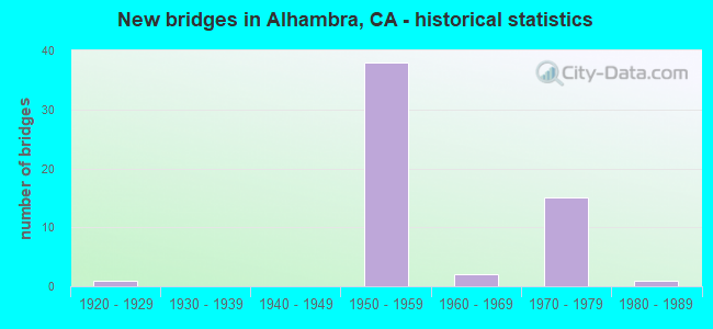
- New bridges - historical statistics
- 11920-1929
- 381950-1959
- 21960-1969
- 151970-1979
- 11980-1989
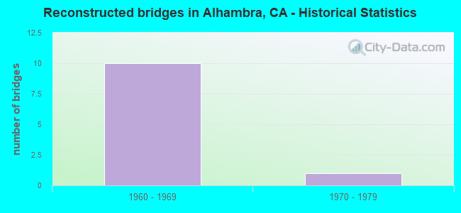
- Reconstructed bridges - Historical Statistics
- 101960-1969
- 11970-1979
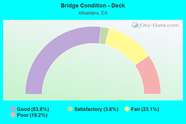
- Bridge Condition - Deck
- 53.8%Good
- 3.8%Satisfactory
- 23.1%Fair
- 19.2%Poor
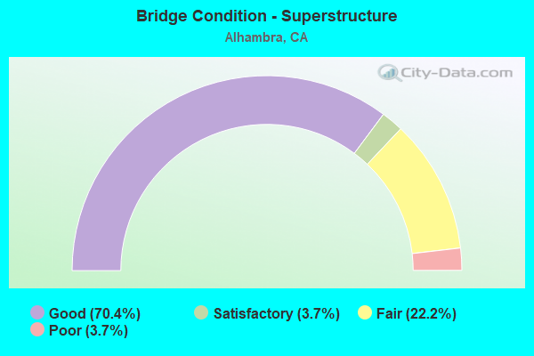
- Bridge Condition - Superstructure
- 70.4%Good
- 3.7%Satisfactory
- 22.2%Fair
- 3.7%Poor
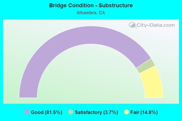
- Bridge Condition - Substructure
- 81.5%Good
- 3.7%Satisfactory
- 14.8%Fair
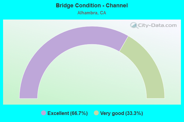
- Bridge Condition - Channel
- 66.7%Excellent
- 33.3%Very good
Find on map >> Show street view
Structure Number: 53 064, Location: 07-LA-005-8.29-DNY (Lat: 33.957900, Lng: -118.111419), Route carried "on" structure: Interstate 5, Year Built: 1953, Year Reconstructed: 1982, Status: Open, Structure Length: 6.19m (20.31ft), Average Daily Traffic: 230,000 (year 2010), Truck Traffic: 7%, Average Future Daily Traffic: 287,022 (year 2037), Design Load: HS 20, Features Intersected: LAKEWOOD BLVD
Minimum Vertical Clearance: 30+ m (98+ ft), Kilometerpoint: 8.290, Lanes on structure: 10, Lanes under structure: 8, Base Highway Network: Yes (, Subroute: 1), Owner: State Highway Agency, Approaching Roadway Width: 46.6m (152.9ft), Skew: 21 degrees, Material/Design: Concrete continuous, Design/Construction: Box Beam or Girders - Multiple, Number Of Spans In Main Unit: 2, Number Of Approach Spans: 2, Length of Maximum Span: 20.4m (66.9ft), Curb-To-Curb Width: 44.8m (147.0ft), Out-to-Out Width: 48.3m (158.5ft)
Condition: Deck: Fair, Superstructure: Good, Substructure: Good, Operating Rating: 99.8 metric tons, Method Used To Determine Operating Rating: Load Factor (LF), Inventory Rating: 32.4 metric tons, Method Used To Determine Inventory Rating: Load Factor (LF), Structural Evaluation: Better than present minimum criteria, Deck Geometry: Superior to present desirable criteria, Underclear: Meets minimum limits, Approach Roadway Alignment: Equal to present desirable criteria, Designated Inspection Frequency: Every 24 months, Inspection Date: November 2020, Deck Structure Type: Concrete Cast-file-Place
Find on map >> Show street view
Structure Number: 53 0647L, Location: 07-LA-010-22.31-ALH (Lat: 34.068414, Lng: -118.151236), Route carried "on" structure: Interstate 10, Year Built: 1952, Year Reconstructed: 1972, Status: Open, Structure Length: 2.50m (8.20ft), Average Daily Traffic: 107,500 (year 2009), Truck Traffic: 6%, Average Future Daily Traffic: 133,213 (year 2040), Design Load: HS 20, Features Intersected: FREMONT AVE
Minimum Vertical Clearance: 30+ m (98+ ft), Kilometerpoint: 22.310, Lanes on structure: 7, Lanes under structure: 4, Base Highway Network: Yes (, Subroute: 1), Owner: State Highway Agency, Approaching Roadway Width: 29.0m (95.1ft), Skew: 1 degrees, Material/Design: Concrete continuous, Design/Construction: Frame, Number Of Spans In Main Unit: 2, Length of Maximum Span: 24.4m (80.1ft), Curb-To-Curb Width: 29.0m (95.1ft), Out-to-Out Width: 29.8m (97.8ft)
Condition: Deck: Good, Superstructure: Good, Substructure: Good, Operating Rating: 57.1 metric tons, Method Used To Determine Operating Rating: Load Factor (LF), Inventory Rating: 33.5 metric tons, Method Used To Determine Inventory Rating: Load Factor (LF), Structural Evaluation: Better than present minimum criteria, Deck Geometry: Meets minimum limits, Underclear: Meets minimum limits, Approach Roadway Alignment: Superior to present desirable criteria, Designated Inspection Frequency: Every 48 months, Inspection Date: January 2021, Deck Structure Type: Concrete Cast-file-Place
Find on map >> Show street view
Structure Number: 53 0647R, Location: 07-LA-010-22.31-ALH (Lat: 34.068164, Lng: -118.150964), Route carried "on" structure: Interstate 10, Year Built: 1952, Year Reconstructed: 1972, Status: Open, Structure Length: 2.50m (8.20ft), Average Daily Traffic: 107,500 (year 2009), Truck Traffic: 6%, Average Future Daily Traffic: 133,213 (year 2040), Design Load: HS 20, Features Intersected: FREMONT AVE
Minimum Vertical Clearance: 30+ m (98+ ft), Kilometerpoint: 22.310, Lanes on structure: 7, Lanes under structure: 4, Base Highway Network: Yes (, Subroute: 1), Owner: State Highway Agency, Approaching Roadway Width: 30.2m (99.1ft), Skew: 1 degrees, Material/Design: Concrete continuous, Design/Construction: Frame, Number Of Spans In Main Unit: 2, Length of Maximum Span: 24.4m (80.1ft), Curb-To-Curb Width: 30.2m (99.1ft), Out-to-Out Width: 31.0m (101.7ft)
Condition: Deck: Good, Superstructure: Good, Substructure: Good, Operating Rating: 57.1 metric tons, Method Used To Determine Operating Rating: Load Factor (LF), Inventory Rating: 33.5 metric tons, Method Used To Determine Inventory Rating: Load Factor (LF), Structural Evaluation: Better than present minimum criteria, Deck Geometry: Somewhat better than minimum adequacy, Underclear: Meets minimum limits, Approach Roadway Alignment: Superior to present desirable criteria, Designated Inspection Frequency: Every 48 months, Inspection Date: January 2021, Deck Structure Type: Concrete Cast-file-Place
Find on map >> Show street view
Structure Number: 53 0648K, Location: 07-LA-010-23.33-ALH (Lat: 34.071778, Lng: -118.134558), Route carried "on" structure: Ramp Interstate 10, Year Built: 1953, Status: Open, Structure Length: 2.50m (8.20ft), Average Daily Traffic: 10,800 (year 2005), Truck Traffic: 2%, Average Future Daily Traffic: 16,789 (year 2040), Design Load: HS 20, Features Intersected: ATLANTIC BLVD
Minimum Vertical Clearance: 30+ m (98+ ft), Kilometerpoint: 23.330, Lanes on structure: 2, Lanes under structure: 4, Owner: State Highway Agency, Approaching Roadway Width: 9.4m (30.8ft), Material/Design: Concrete continuous, Design/Construction: Slab, Number Of Spans In Main Unit: 2, Length of Maximum Span: 11.9m (39.0ft), Curb-To-Curb Width: 9.4m (30.8ft), Out-to-Out Width: 10.2m (33.5ft)
Condition: Deck: Good, Superstructure: Good, Substructure: Good, Operating Rating: 40.2 metric tons, Method Used To Determine Operating Rating: Load and Resistance Factor Rating (LRFR) rating reported by rating factor(RF) method using HL-93 loadings, Inventory Rating: 31.1 metric tons, Method Used To Determine Inventory Rating: Load and Resistance Factor Rating (LRFR) rating reported by rating factor(RF) method using HL-93 loadings, Structural Evaluation: Better than present minimum criteria, Deck Geometry: Somewhat better than minimum adequacy, Underclear: Meets minimum limits, Approach Roadway Alignment: Superior to present desirable criteria, Designated Inspection Frequency: Every 24 months, Inspection Date: December 2020, Deck Structure Type: Concrete Cast-file-Place
Find on map >> Show street view
Structure Number: 53 0648L, Location: 07-LA-010-23.33-ALH (Lat: 34.071528, Lng: -118.134578), Route carried "on" structure: Interstate 10, Year Built: 1953, Year Reconstructed: 1972, Status: Open, Structure Length: 2.50m (8.20ft), Average Daily Traffic: 107,500 (year 2009), Truck Traffic: 6%, Average Future Daily Traffic: 133,213 (year 2040), Design Load: HS 20, Features Intersected: ATLANTIC BLVD
Minimum Vertical Clearance: 30+ m (98+ ft), Kilometerpoint: 23.330, Lanes on structure: 6, Lanes under structure: 4, Base Highway Network: Yes (, Subroute: 1), Owner: State Highway Agency, Approaching Roadway Width: 23.5m (77.1ft), Material/Design: Concrete continuous, Design/Construction: Slab, Number Of Spans In Main Unit: 2, Length of Maximum Span: 24.1m (79.1ft), Curb-To-Curb Width: 23.5m (77.1ft), Out-to-Out Width: 24.3m (79.7ft)
Condition: Deck: Good, Superstructure: Good, Substructure: Good, Operating Rating: 40.5 metric tons, Method Used To Determine Operating Rating: Load and Resistance Factor Rating (LRFR) rating reported by rating factor(RF) method using HL-93 loadings, Inventory Rating: 30.1 metric tons, Method Used To Determine Inventory Rating: Load and Resistance Factor Rating (LRFR) rating reported by rating factor(RF) method using HL-93 loadings, Structural Evaluation: Better than present minimum criteria, Deck Geometry: High priority of replacement, Underclear: Meets minimum limits, Approach Roadway Alignment: Superior to present desirable criteria, Designated Inspection Frequency: Every 48 months, Inspection Date: December 2020, Deck Structure Type: Concrete Cast-file-Place
Find on map >> Show street view
Structure Number: 53 0648R, Location: 07-LA-010-23.33-ALH (Lat: 34.071253, Lng: -118.134558), Route carried "on" structure: Interstate 10, Year Built: 1953, Year Reconstructed: 1972, Status: Open, Structure Length: 2.50m (8.20ft), Average Daily Traffic: 107,500 (year 2009), Truck Traffic: 6%, Average Future Daily Traffic: 133,213 (year 2040), Design Load: HS 20, Features Intersected: ATLANTIC BLVD
Minimum Vertical Clearance: 30+ m (98+ ft), Kilometerpoint: 23.330, Lanes on structure: 6, Lanes under structure: 4, Base Highway Network: Yes (, Subroute: 1), Owner: State Highway Agency, Approaching Roadway Width: 23.5m (77.1ft), Material/Design: Concrete continuous, Design/Construction: Slab, Number Of Spans In Main Unit: 2, Length of Maximum Span: 24.1m (79.1ft), Curb-To-Curb Width: 23.5m (77.1ft), Out-to-Out Width: 24.3m (79.7ft)
Condition: Deck: Good, Superstructure: Good, Substructure: Good, Operating Rating: 71.6 metric tons, Method Used To Determine Operating Rating: Load Factor (LF), Inventory Rating: 32.6 metric tons, Method Used To Determine Inventory Rating: Load Factor (LF), Structural Evaluation: Better than present minimum criteria, Deck Geometry: High priority of replacement, Underclear: Meets minimum limits, Approach Roadway Alignment: Superior to present desirable criteria, Designated Inspection Frequency: Every 48 months, Inspection Date: December 2020, Deck Structure Type: Concrete Cast-file-Place
Find on map >> Show street view
Structure Number: 53 0648S, Location: 07-LA-010-23.33-ALH (Lat: 34.071139, Lng: -118.134564), Route carried "on" structure: Ramp Interstate 10, Year Built: 1953, Status: Open, Structure Length: 2.50m (8.20ft), Average Daily Traffic: 12,600 (year 2005), Truck Traffic: 2%, Average Future Daily Traffic: 19,195 (year 2040), Design Load: HS 20, Features Intersected: ATLANTIC BLVD
Minimum Vertical Clearance: 30+ m (98+ ft), Kilometerpoint: 23.330, Lanes on structure: 2, Lanes under structure: 4, Owner: State Highway Agency, Approaching Roadway Width: 9.5m (31.2ft), Material/Design: Concrete continuous, Design/Construction: Slab, Number Of Spans In Main Unit: 2, Length of Maximum Span: 11.9m (39.0ft), Curb-To-Curb Width: 9.5m (31.2ft), Out-to-Out Width: 10.3m (33.8ft)
Condition: Deck: Good, Superstructure: Good, Substructure: Good, Operating Rating: 40.2 metric tons, Method Used To Determine Operating Rating: Load and Resistance Factor Rating (LRFR) rating reported by rating factor(RF) method using HL-93 loadings, Inventory Rating: 31.1 metric tons, Method Used To Determine Inventory Rating: Load and Resistance Factor Rating (LRFR) rating reported by rating factor(RF) method using HL-93 loadings, Structural Evaluation: Better than present minimum criteria, Deck Geometry: Somewhat better than minimum adequacy, Underclear: Meets minimum limits, Approach Roadway Alignment: Superior to present desirable criteria, Designated Inspection Frequency: Every 24 months, Inspection Date: December 2020, Deck Structure Type: Concrete Cast-file-Place
Find on map >> Show street view
Structure Number: 53 0649K, Location: 07-LA-010-23.99-ALH (Lat: 34.071919, Lng: -118.123047), Route carried "on" structure: Ramp Interstate 10, Year Built: 1953, Status: Open, Structure Length: 2.41m (7.91ft), Average Daily Traffic: 10,100 (year 2016), Truck Traffic: 2%, Average Future Daily Traffic: 14,941 (year 2038), Design Load: HS 20, Features Intersected: GARFIELD AVE
Minimum Vertical Clearance: 30+ m (98+ ft), Kilometerpoint: 23.990, Lanes on structure: 2, Lanes under structure: 4, Owner: State Highway Agency, Approaching Roadway Width: 9.5m (31.2ft), Material/Design: Concrete continuous, Design/Construction: Slab, Number Of Spans In Main Unit: 2, Length of Maximum Span: 11.6m (38.1ft), Curb-To-Curb Width: 9.5m (31.2ft), Out-to-Out Width: 10.3m (33.8ft)
Condition: Deck: Good, Superstructure: Good, Substructure: Good, Operating Rating: 58.3 metric tons, Method Used To Determine Operating Rating: Load Factor (LF), Inventory Rating: 35.0 metric tons, Method Used To Determine Inventory Rating: Load Factor (LF), Structural Evaluation: Better than present minimum criteria, Deck Geometry: Somewhat better than minimum adequacy, Underclear: Meets minimum limits, Approach Roadway Alignment: Superior to present desirable criteria, Designated Inspection Frequency: Every 48 months, Inspection Date: January 2021, Deck Structure Type: Concrete Cast-file-Place
Find on map >> Show street view
Structure Number: 53 0649L, Location: 07-LA-010-23.99-ALH (Lat: 34.071675, Lng: -118.123078), Route carried "on" structure: Interstate 10, Year Built: 1953, Year Reconstructed: 1972, Status: Open, Structure Length: 2.41m (7.91ft), Average Daily Traffic: 107,500 (year 2016), Truck Traffic: 6%, Average Future Daily Traffic: 130,146 (year 2038), Design Load: HS 20, Features Intersected: GARFIELD AVE
Minimum Vertical Clearance: 30+ m (98+ ft), Kilometerpoint: 23.990, Lanes on structure: 6, Lanes under structure: 4, Base Highway Network: Yes (, Subroute: 1), Owner: State Highway Agency, Approaching Roadway Width: 23.5m (77.1ft), Material/Design: Concrete continuous, Design/Construction: Slab, Number Of Spans In Main Unit: 2, Number Of Approach Spans: 2, Length of Maximum Span: 24.1m (79.1ft), Curb-To-Curb Width: 23.5m (77.1ft), Out-to-Out Width: 24.3m (79.7ft)
Condition: Deck: Good, Superstructure: Good, Substructure: Good, Operating Rating: 65.3 metric tons, Method Used To Determine Operating Rating: Load Factor (LF), Inventory Rating: 32.6 metric tons, Method Used To Determine Inventory Rating: Load Factor (LF), Structural Evaluation: Better than present minimum criteria, Deck Geometry: High priority of replacement, Underclear: Meets minimum limits, Approach Roadway Alignment: Superior to present desirable criteria, Designated Inspection Frequency: Every 48 months, Inspection Date: January 2021, Deck Structure Type: Concrete Cast-file-Place
Find on map >> Show street view
Structure Number: 53 0649R, Location: 07-LA-010-23.99-ALH (Lat: 34.071403, Lng: -118.123058), Route carried "on" structure: Interstate 10, Year Built: 1953, Year Reconstructed: 1972, Status: Open, Structure Length: 2.41m (7.91ft), Average Daily Traffic: 107,500 (year 2016), Truck Traffic: 6%, Average Future Daily Traffic: 130,146 (year 2038), Design Load: HS 20, Features Intersected: GARFIELD AVE
Minimum Vertical Clearance: 30+ m (98+ ft), Kilometerpoint: 23.990, Lanes on structure: 6, Lanes under structure: 4, Base Highway Network: Yes (, Subroute: 1), Owner: State Highway Agency, Approaching Roadway Width: 23.5m (77.1ft), Material/Design: Concrete continuous, Design/Construction: Slab, Number Of Spans In Main Unit: 2, Number Of Approach Spans: 2, Length of Maximum Span: 24.1m (79.1ft), Curb-To-Curb Width: 23.5m (77.1ft), Out-to-Out Width: 24.3m (79.7ft)
Condition: Deck: Good, Superstructure: Good, Substructure: Good, Operating Rating: 99.8 metric tons, Method Used To Determine Operating Rating: Load Factor (LF), Inventory Rating: 49.0 metric tons, Method Used To Determine Inventory Rating: Load Factor (LF), Structural Evaluation: Better than present minimum criteria, Deck Geometry: High priority of replacement, Underclear: Meets minimum limits, Approach Roadway Alignment: Superior to present desirable criteria, Designated Inspection Frequency: Every 48 months, Inspection Date: January 2021, Deck Structure Type: Concrete Cast-file-Place
Find on map >> Show street view
Structure Number: 53 0649S, Location: 07-LA-010-23.99-ALH (Lat: 34.071283, Lng: -118.123058), Route carried "on" structure: Ramp Interstate 10, Year Built: 1953, Status: Open, Structure Length: 2.41m (7.91ft), Average Daily Traffic: 11,900 (year 2016), Truck Traffic: 2%, Average Future Daily Traffic: 17,651 (year 2038), Design Load: HS 20, Features Intersected: GARFIELD AVE
Minimum Vertical Clearance: 30+ m (98+ ft), Kilometerpoint: 23.990, Lanes on structure: 2, Lanes under structure: 4, Owner: State Highway Agency, Approaching Roadway Width: 9.5m (31.2ft), Material/Design: Concrete continuous, Design/Construction: Slab, Number Of Spans In Main Unit: 2, Length of Maximum Span: 11.9m (39.0ft), Curb-To-Curb Width: 9.5m (31.2ft), Out-to-Out Width: 10.3m (33.8ft)
Condition: Deck: Good, Superstructure: Good, Substructure: Good, Operating Rating: 58.3 metric tons, Method Used To Determine Operating Rating: Load Factor (LF), Inventory Rating: 35.0 metric tons, Method Used To Determine Inventory Rating: Load Factor (LF), Structural Evaluation: Better than present minimum criteria, Deck Geometry: Somewhat better than minimum adequacy, Underclear: Meets minimum limits, Approach Roadway Alignment: Superior to present desirable criteria, Designated Inspection Frequency: Every 48 months, Inspection Date: January 2021, Deck Structure Type: Concrete Cast-file-Place
Find on map >> Show street view
Structure Number: 53 0651L, Location: 07-LA-010-24.83-ALH (Lat: 34.071928, Lng: -118.108333), Route carried "on" structure: Interstate 10, Year Built: 1953, Year Reconstructed: 1972, Status: Open, Structure Length: 2.41m (7.91ft), Average Daily Traffic: 107,500 (year 2011), Truck Traffic: 6%, Average Future Daily Traffic: 132,771 (year 2041), Design Load: HS 20, Features Intersected: NEW AVE
Minimum Vertical Clearance: 30+ m (98+ ft), Kilometerpoint: 24.830, Lanes on structure: 8, Lanes under structure: 4, Base Highway Network: Yes (, Subroute: 1), Owner: State Highway Agency, Approaching Roadway Width: 23.4m (76.8ft), Material/Design: Concrete continuous, Design/Construction: Slab, Number Of Spans In Main Unit: 2, Length of Maximum Span: 24.1m (79.1ft), Curb or Sidewalk Widths: Left: 3.0m (9.8ft), Right: 0.0m, Curb-To-Curb Width: 23.4m (76.8ft), Out-to-Out Width: 35.9m (117.8ft)
Condition: Deck: Fair, Superstructure: Fair, Substructure: Good, Operating Rating: 99.8 metric tons, Method Used To Determine Operating Rating: Load Factor (LF), Inventory Rating: 53.5 metric tons, Method Used To Determine Inventory Rating: Load Factor (LF), Structural Evaluation: Somewhat better than minimum adequacy, Deck Geometry: High priority of replacement, Underclear: Meets minimum limits, Approach Roadway Alignment: Equal to present desirable criteria, Designated Inspection Frequency: Every 24 months, Inspection Date: Febuary 2021, Deck Structure Type: Concrete Cast-file-Place
Find on map >> Show street view
Structure Number: 53 0651R, Location: 07-LA-010-24.83-ALH (Lat: 34.071586, Lng: -118.108331), Route carried "on" structure: Interstate 10, Year Built: 1953, Year Reconstructed: 1972, Status: Open, Structure Length: 2.44m (8.01ft), Average Daily Traffic: 107,500 (year 2011), Truck Traffic: 6%, Average Future Daily Traffic: 132,771 (year 2041), Design Load: HS 20, Features Intersected: NEW AVE
Minimum Vertical Clearance: 30+ m (98+ ft), Kilometerpoint: 24.830, Lanes on structure: 6, Lanes under structure: 4, Base Highway Network: Yes (, Subroute: 1), Owner: State Highway Agency, Approaching Roadway Width: 23.5m (77.1ft), Material/Design: Concrete continuous, Design/Construction: Slab, Number Of Spans In Main Unit: 2, Length of Maximum Span: 24.1m (79.1ft), Curb-To-Curb Width: 23.5m (77.1ft), Out-to-Out Width: 24.3m (79.7ft)
Condition: Deck: Fair, Superstructure: Fair, Substructure: Good, Operating Rating: 65.3 metric tons, Method Used To Determine Operating Rating: Load Factor (LF), Inventory Rating: 32.6 metric tons, Method Used To Determine Inventory Rating: Load Factor (LF), Structural Evaluation: Somewhat better than minimum adequacy, Deck Geometry: High priority of replacement, Underclear: Meets minimum limits, Approach Roadway Alignment: Superior to present desirable criteria, Designated Inspection Frequency: Every 24 months, Inspection Date: Febuary 2021, Deck Structure Type: Concrete Cast-file-Place
Find on map >> Show street view
Structure Number: 53 0801, Location: 07-LA-101-7.38-LA (Lat: 34.107556, Lng: -118.329500), Route carried "on" structure: US 101, Year Built: 1952, Status: Open, Structure Length: 1.31m (4.30ft), Average Daily Traffic: 154,000 (year 2018), Truck Traffic: 10%, Average Future Daily Traffic: 208,225 (year 2042), Design Load: HS 20, Features Intersected: HOLLY DR
Minimum Vertical Clearance: 30+ m (98+ ft), Kilometerpoint: 7.380, Lanes on structure: 11, Lanes under structure: 2, Base Highway Network: Yes (Inventory Route: 1, Subroute: 1), Owner: State Highway Agency, Approaching Roadway Width: 78.6m (257.9ft), Skew: 33 degrees, Material/Design: Concrete, Design/Construction: Arch - Deck, Number Of Spans In Main Unit: 1, Number Of Approach Spans: 1, Length of Maximum Span: 11.6m (38.1ft), Curb-To-Curb Width: 76.0m (249.3ft), Out-to-Out Width: 92.9m (304.8ft)
Condition: Superstructure: Good, Substructure: Good, Operating Rating: 99.8 metric tons, Method Used To Determine Operating Rating: Load Factor (LF), Inventory Rating: 99.8 metric tons, Method Used To Determine Inventory Rating: Load Factor (LF), Structural Evaluation: Better than present minimum criteria, Deck Geometry: Superior to present desirable criteria, Underclear: Meets minimum limits, Approach Roadway Alignment: Equal to present desirable criteria, Designated Inspection Frequency: Every 48 months, Inspection Date: Febuary 2020, Wearing Surface/Protective System: Wearing Surface: Monolithic Concrete
Find on map >> Show street view
Structure Number: 53 0809L, Location: 07-LA-010-23.65-ALH (Lat: 34.071597, Lng: -118.128931), Route carried "on" structure: Interstate 10, Year Built: 1953, Year Reconstructed: 1972, Status: Open, Structure Length: 2.04m (6.69ft), Average Daily Traffic: 107,500 (year 2009), Truck Traffic: 6%, Average Future Daily Traffic: 133,213 (year 2040), Design Load: HS 20, Features Intersected: SIXTH STREET
Minimum Vertical Clearance: 30+ m (98+ ft), Kilometerpoint: 23.650, Lanes on structure: 6, Lanes under structure: 2, Base Highway Network: Yes (, Subroute: 1), Owner: State Highway Agency, Approaching Roadway Width: 25.8m (84.6ft), Skew: 20 degrees, Material/Design: Concrete, Design/Construction: Frame, Number Of Spans In Main Unit: 1, Length of Maximum Span: 20.4m (66.9ft), Curb or Sidewalk Widths: Left: 1.5m (4.9ft), Right: 0.0m, Curb-To-Curb Width: 25.8m (84.6ft), Out-to-Out Width: 37.4m (122.7ft)
Condition: Deck: Good, Superstructure: Good, Substructure: Good, Operating Rating: 99.8 metric tons, Method Used To Determine Operating Rating: Load Factor (LF), Inventory Rating: 32.6 metric tons, Method Used To Determine Inventory Rating: Load Factor (LF), Structural Evaluation: Better than present minimum criteria, Deck Geometry: Meets minimum limits, Underclear: Somewhat better than minimum adequacy, Approach Roadway Alignment: Superior to present desirable criteria, Designated Inspection Frequency: Every 48 months, Inspection Date: January 2021, Deck Structure Type: Concrete Cast-file-Place, Wearing Surface/Protective System: Wearing Surface: Bituminous
Find on map >> Show street view
Structure Number: 53 0809R, Location: 07-LA-010-23.65-ALH (Lat: 34.071311, Lng: -118.128933), Route carried "on" structure: Interstate 10, Year Built: 1953, Year Reconstructed: 1972, Status: Open, Structure Length: 2.04m (6.69ft), Average Daily Traffic: 107,500 (year 2009), Truck Traffic: 6%, Average Future Daily Traffic: 133,213 (year 2040), Design Load: HS 20, Features Intersected: SIXTH STREET
Minimum Vertical Clearance: 30+ m (98+ ft), Kilometerpoint: 23.650, Lanes on structure: 6, Lanes under structure: 2, Base Highway Network: Yes (, Subroute: 1), Owner: State Highway Agency, Approaching Roadway Width: 25.8m (84.6ft), Skew: 30 degrees, Material/Design: Concrete, Design/Construction: Frame, Number Of Spans In Main Unit: 1, Length of Maximum Span: 20.4m (66.9ft), Curb or Sidewalk Widths: Left: 1.5m (4.9ft), Right: 0.0m, Curb-To-Curb Width: 25.8m (84.6ft), Out-to-Out Width: 37.4m (122.7ft)
Condition: Deck: Good, Superstructure: Good, Substructure: Good, Operating Rating: 99.8 metric tons, Method Used To Determine Operating Rating: Load Factor (LF), Inventory Rating: 32.6 metric tons, Method Used To Determine Inventory Rating: Load Factor (LF), Structural Evaluation: Better than present minimum criteria, Deck Geometry: Meets minimum limits, Underclear: Somewhat better than minimum adequacy, Approach Roadway Alignment: Superior to present desirable criteria, Designated Inspection Frequency: Every 48 months, Inspection Date: January 2021, Deck Structure Type: Concrete Cast-file-Place, Wearing Surface/Protective System: Wearing Surface: Bituminous
Find on map >> Show street view
Structure Number: 53 2507R, Location: 07-LA-010S-21.53-ALH (Lat: 34.062461, Lng: -118.163025), Route carried "on" structure: Interstate 10, Year Built: 1974, Status: Open, Structure Length: 9.43m (30.94ft), Average Daily Traffic: 30,500 (year 2016), Truck Traffic: 7%, Average Future Daily Traffic: 30,500 (year 2040), Design Load: HS 20, Features Intersected: WB 10 & SB 710 CONNECTOR
Minimum Vertical Clearance: 30+ m (98+ ft), Kilometerpoint: 21.530, Lanes on structure: 1, Lanes under structure: 6, Base Highway Network: Yes (, Subroute: 1), Toll: On toll road, Owner: State Highway Agency, Approaching Roadway Width: 8.5m (27.9ft), Skew: 5 degrees, Material/Design: Prestressed concrete continuous, Design/Construction: Box Beam or Girders - Multiple, Number Of Spans In Main Unit: 2, Length of Maximum Span: 50.0m (164.0ft), Curb-To-Curb Width: 8.5m (27.9ft), Out-to-Out Width: 9.3m (30.5ft)
Condition: Deck: Good, Superstructure: Good, Substructure: Good, Operating Rating: 45.0 metric tons, Method Used To Determine Operating Rating: Load and Resistance Factor Rating (LRFR) rating reported by rating factor(RF) method using HL-93 loadings, Inventory Rating: 32.7 metric tons, Method Used To Determine Inventory Rating: Load and Resistance Factor Rating (LRFR) rating reported by rating factor(RF) method using HL-93 loadings, Structural Evaluation: Better than present minimum criteria, Deck Geometry: Meets minimum limits, Underclear: Meets minimum limits, Approach Roadway Alignment: Equal to present desirable criteria, Designated Inspection Frequency: Every 24 months, Inspection Date: October 2021, Deck Structure Type: Concrete Cast-file-Place
Find on map >> Show street view
Structure Number: 53 2541L, Location: 07-LA-010S-21.55-ALH (Lat: 34.062711, Lng: -118.162739), Route carried "on" structure: Interstate 10, Year Built: 1974, Status: Open, Structure Length: 9.68m (31.76ft), Average Daily Traffic: 30,500 (year 2016), Truck Traffic: 6%, Average Future Daily Traffic: 30,500 (year 2040), Design Load: HS 20, Features Intersected: WBD 10 & SB 710 CONN
Minimum Vertical Clearance: 30+ m (98+ ft), Kilometerpoint: 21.550, Lanes on structure: 1, Lanes under structure: 6, Base Highway Network: Yes (, Subroute: 1), Toll: On toll road, Owner: State Highway Agency, Approaching Roadway Width: 7.8m (25.6ft), Skew: 5 degrees, Material/Design: Prestressed concrete continuous, Design/Construction: Box Beam or Girders - Multiple, Number Of Spans In Main Unit: 2, Length of Maximum Span: 52.7m (172.9ft), Curb-To-Curb Width: 7.8m (25.6ft), Out-to-Out Width: 8.5m (27.9ft)
Condition: Deck: Fair, Superstructure: Good, Substructure: Fair, Operating Rating: 63.5 metric tons, Method Used To Determine Operating Rating: Load and Resistance Factor Rating (LRFR) rating reported by rating factor(RF) method using HL-93 loadings, Inventory Rating: 46.7 metric tons, Method Used To Determine Inventory Rating: Load and Resistance Factor Rating (LRFR) rating reported by rating factor(RF) method using HL-93 loadings, Structural Evaluation: Somewhat better than minimum adequacy, Deck Geometry: High priority of replacement, Underclear: High priority of corrective action, Approach Roadway Alignment: Equal to present desirable criteria, Designated Inspection Frequency: Every 24 months, Inspection Date: October 2021, Deck Structure Type: Concrete Cast-file-Place
Find on map >> Show street view
Structure Number: 53C0096, Location: 0.1 M NE FWY 5 (Lat: 34.107975, Lng: -118.254050), Route carried "on" structure: City street , Year Built: 1927, Status: Open, Structure Length: 14.30m (46.92ft), Average Daily Traffic: 41,100 (year 2016), Truck Traffic: 2%, Average Future Daily Traffic: 68,260 (year 2038), Design Load: HS 20, Features Intersected: LOS ANGELES RIVER, Facility Carried by Structure: FLETCHER DR
Minimum Vertical Clearance: 30+ m (98+ ft), Kilometerpoint: 0.000, Lanes on structure: 4, Owner: City or Municipal Highway Agency, Approaching Roadway Width: 17.1m (56.1ft), Skew: 4 degrees, Material/Design: Concrete continuous, Design/Construction: Tee Beam, Number Of Spans In Main Unit: 7, Length of Maximum Span: 20.4m (66.9ft), Curb or Sidewalk Widths: Left: 2.0m (6.6ft), Right: 2.0m (6.6ft), Curb-To-Curb Width: 17.1m (56.1ft), Out-to-Out Width: 21.8m (71.5ft)
Condition: Deck: Good, Superstructure: Good, Substructure: Good, Channel: Very good, Operating Rating: 67.1 metric tons, Method Used To Determine Operating Rating: Load Factor (LF), Inventory Rating: 40.2 metric tons, Method Used To Determine Inventory Rating: Load Factor (LF), Structural Evaluation: Better than present minimum criteria, Deck Geometry: Somewhat better than minimum adequacy, Waterway Adequacy: Equal to present desirable criteria, Approach Roadway Alignment: Equal to present desirable criteria, Designated Inspection Frequency: Every 48 months, Inspection Date: April 2020, Deck Structure Type: Concrete Cast-file-Place, Wearing Surface/Protective System: Wearing Surface: Bituminous
Find on map >> Show street view
Structure Number: 53C1664, Location: 50FT S/O MISSION RD (Lat: 34.081331, Lng: -118.141833), Route carried "on" structure: City street QR33, Year Built: 1979, Status: Open, Structure Length: 2.21m (7.25ft), Average Daily Traffic: 14,009 (year 2015), Truck Traffic: 2%, Average Future Daily Traffic: 15,796 (year 2041), Design Load: HS 20, Features Intersected: UPRR, Facility Carried by Structure: MARENGO AVE
Minimum Vertical Clearance: 30.47m (99.97ft), Kilometerpoint: 0.000, Lanes on structure: 3, Owner: City or Municipal Highway Agency, Approaching Roadway Width: 12.5m (41.0ft), Skew: 2 degrees, Material/Design: Concrete, Design/Construction: Box Beam or Girders - Single/Spread, Number Of Spans In Main Unit: 1, Length of Maximum Span: 19.2m (63.0ft), Curb or Sidewalk Widths: Left: 2.2m (7.2ft), Right: 2.2m (7.2ft), Curb-To-Curb Width: 13.9m (45.6ft), Out-to-Out Width: 18.8m (61.7ft)
Condition: Deck: Poor, Superstructure: Good, Substructure: Good, Operating Rating: 99.8 metric tons, Method Used To Determine Operating Rating: Load Factor (LF), Inventory Rating: 67.1 metric tons, Method Used To Determine Inventory Rating: Load Factor (LF), Structural Evaluation: Better than present minimum criteria, Deck Geometry: Somewhat better than minimum adequacy, Underclear: Somewhat better than minimum adequacy, Approach Roadway Alignment: Equal to present desirable criteria, Designated Inspection Frequency: Every 24 months, Inspection Date: July 2021, Deck Structure Type: Concrete Cast-file-Place
Find on map >> Show street view
Structure Number: 53C1665, Location: 50FT S/O MISSION RD (Lat: 34.082897, Lng: -118.138136), Route carried "on" structure: City street , Year Built: 1979, Status: Open, Structure Length: 1.77m (5.81ft), Average Daily Traffic: 3,300 (year 2015), Truck Traffic: 2%, Average Future Daily Traffic: 5,444 (year 2041), Design Load: HS 20, Features Intersected: UPRR, Facility Carried by Structure: MARGUERITA AVE
Minimum Vertical Clearance: 30.47m (99.97ft), Kilometerpoint: 0.000, Lanes on structure: 3, Owner: City or Municipal Highway Agency, Approaching Roadway Width: 11.0m (36.1ft), Skew: 2 degrees, Material/Design: Prestressed concrete, Design/Construction: Slab, Number Of Spans In Main Unit: 1, Length of Maximum Span: 16.5m (54.1ft), Curb or Sidewalk Widths: Left: 2.2m (7.2ft), Right: 2.3m (7.5ft), Curb-To-Curb Width: 13.8m (45.3ft), Out-to-Out Width: 18.9m (62.0ft)
Condition: Deck: Fair, Superstructure: Fair, Substructure: Good, Operating Rating: 83.9 metric tons, Method Used To Determine Operating Rating: Load Factor (LF), Inventory Rating: 37.3 metric tons, Method Used To Determine Inventory Rating: Load Factor (LF), Structural Evaluation: Somewhat better than minimum adequacy, Deck Geometry: Somewhat better than minimum adequacy, Underclear: Equal to present minimum criteria, Approach Roadway Alignment: Somewhat better than minimum adequacy, Designated Inspection Frequency: Every 24 months, Inspection Date: July 2021, Deck Structure Type: Concrete Cast-file-Place
Find on map >> Show street view
Structure Number: 53C1666, Location: 50FT S/O MISSION RD (Lat: 34.084492, Lng: -118.134442), Route carried "on" structure: City street L062, Year Built: 1979, Status: Open, Structure Length: 1.83m (6.00ft), Average Daily Traffic: 35,177 (year 2012), Truck Traffic: 3%, Average Future Daily Traffic: 42,350 (year 2041), Design Load: HS 20, Features Intersected: UPRR, Facility Carried by Structure: ATLANTIC BLVD
Minimum Vertical Clearance: 30.47m (99.97ft), Kilometerpoint: 0.000, Lanes on structure: 5, Owner: City or Municipal Highway Agency, Approaching Roadway Width: 16.5m (54.1ft), Skew: 2 degrees, Material/Design: Concrete, Design/Construction: Box Beam or Girders - Multiple, Number Of Spans In Main Unit: 1, Length of Maximum Span: 16.2m (53.1ft), Curb or Sidewalk Widths: Left: 2.2m (7.2ft), Right: 2.2m (7.2ft), Curb-To-Curb Width: 20.7m (67.9ft), Out-to-Out Width: 25.6m (84.0ft)
Condition: Deck: Poor, Superstructure: Fair, Substructure: Fair, Operating Rating: 94.3 metric tons, Method Used To Determine Operating Rating: Load Factor (LF), Inventory Rating: 56.7 metric tons, Method Used To Determine Inventory Rating: Load Factor (LF), Structural Evaluation: Somewhat better than minimum adequacy, Deck Geometry: Somewhat better than minimum adequacy, Underclear: Somewhat better than minimum adequacy, Approach Roadway Alignment: Equal to present desirable criteria, Designated Inspection Frequency: Every 24 months, Inspection Date: July 2021, Deck Structure Type: Concrete Cast-file-Place
Find on map >> Show street view
Structure Number: 53C1667, Location: 50FT S/O MISSION RD (Lat: 34.086667, Lng: -118.129331), Route carried "on" structure: City street RP18, Year Built: 1979, Status: Open, Structure Length: 1.65m (5.41ft), Average Daily Traffic: 8,778 (year 2015), Truck Traffic: 2%, Average Future Daily Traffic: 9,757 (year 2041), Features Intersected: UPRR, Facility Carried by Structure: SIXTH ST
Minimum Vertical Clearance: 30+ m (98+ ft), Kilometerpoint: 0.000, Lanes on structure: 3, Owner: City or Municipal Highway Agency, Approaching Roadway Width: 11.0m (36.1ft), Skew: 1 degrees, Material/Design: Prestressed concrete, Design/Construction: Slab, Number Of Spans In Main Unit: 1, Length of Maximum Span: 14.6m (47.9ft), Curb or Sidewalk Widths: Left: 2.2m (7.2ft), Right: 2.2m (7.2ft), Curb-To-Curb Width: 14.3m (46.9ft), Out-to-Out Width: 19.1m (62.7ft)
Condition: Deck: Satisfactory, Superstructure: Satisfactory, Substructure: Satisfactory, Operating Rating: 99.8 metric tons, Method Used To Determine Operating Rating: Load Factor (LF), Inventory Rating: 61.9 metric tons, Method Used To Determine Inventory Rating: Load Factor (LF), Structural Evaluation: Equal to present minimum criteria, Deck Geometry: Somewhat better than minimum adequacy, Underclear: Somewhat better than minimum adequacy, Approach Roadway Alignment: Equal to present desirable criteria, Designated Inspection Frequency: Every 48 months, Inspection Date: July 2021, Deck Structure Type: Concrete Cast-file-Place
Find on map >> Show street view
Structure Number: 53C1668, Location: 50FT S/O MISSION RD (Lat: 34.087519, Lng: -118.127303), Route carried "on" structure: City street , Year Built: 1979, Status: Open, Structure Length: 1.83m (6.00ft), Average Daily Traffic: 5,050 (year 2012), Truck Traffic: 2%, Average Future Daily Traffic: 5,808 (year 2041), Design Load: HS 20, Features Intersected: UPRR, Facility Carried by Structure: FOURTH ST
Minimum Vertical Clearance: 30.47m (99.97ft), Kilometerpoint: 0.000, Lanes on structure: 2, Owner: City or Municipal Highway Agency, Approaching Roadway Width: 11.0m (36.1ft), Skew: 2 degrees, Material/Design: Concrete, Design/Construction: Box Beam or Girders - Single/Spread, Number Of Spans In Main Unit: 1, Length of Maximum Span: 14.0m (45.9ft), Curb or Sidewalk Widths: Left: 2.3m (7.5ft), Right: 2.2m (7.2ft), Curb-To-Curb Width: 13.9m (45.6ft), Out-to-Out Width: 19.0m (62.3ft)
Condition: Deck: Fair, Superstructure: Fair, Substructure: Fair, Operating Rating: 94.3 metric tons, Method Used To Determine Operating Rating: Load Factor (LF), Inventory Rating: 56.4 metric tons, Method Used To Determine Inventory Rating: Load Factor (LF), Structural Evaluation: Somewhat better than minimum adequacy, Deck Geometry: Superior to present desirable criteria, Underclear: Somewhat better than minimum adequacy, Approach Roadway Alignment: Equal to present desirable criteria, Designated Inspection Frequency: Every 24 months, Inspection Date: July 2021, Deck Structure Type: Concrete Cast-file-Place
Find on map >> Show street view
Structure Number: 53C1669, Location: 50FT S/O W MISSION RD (Lat: 34.089394, Lng: -118.122936), Route carried "on" structure: City street L064, Year Built: 1979, Status: Open, Structure Length: 1.80m (5.91ft), Average Daily Traffic: 34,511 (year 2015), Truck Traffic: 2%, Average Future Daily Traffic: 43,574 (year 2041), Design Load: HS 20, Features Intersected: UPRR, Facility Carried by Structure: GARFIELD AVE
Minimum Vertical Clearance: 30.47m (99.97ft), Kilometerpoint: 0.000, Lanes on structure: 6, Owner: City or Municipal Highway Agency, Approaching Roadway Width: 17.1m (56.1ft), Skew: 2 degrees, Material/Design: Concrete, Design/Construction: Box Beam or Girders - Multiple, Number Of Spans In Main Unit: 1, Length of Maximum Span: 17.1m (56.1ft), Curb or Sidewalk Widths: Left: 2.2m (7.2ft), Right: 2.2m (7.2ft), Curb-To-Curb Width: 20.7m (67.9ft), Out-to-Out Width: 25.6m (84.0ft)
Condition: Deck: Poor, Superstructure: Fair, Substructure: Good, Operating Rating: 69.7 metric tons, Method Used To Determine Operating Rating: Load Factor (LF), Inventory Rating: 41.8 metric tons, Method Used To Determine Inventory Rating: Load Factor (LF), Structural Evaluation: Somewhat better than minimum adequacy, Deck Geometry: High priority of replacement, Underclear: Somewhat better than minimum adequacy, Approach Roadway Alignment: Better than present minimum criteria, Designated Inspection Frequency: Every 24 months, Inspection Date: July 2021, Bridge Improvement Cost: $460,000, Roadway Improvement Cost: $251,000, Total Project Cost: $2,114,000 ( Estimate for 2017), Deck Structure Type: Concrete Cast-file-Place
Find on map >> Show street view
Structure Number: 53C1674, Location: 50FT S/O MISSION RD (Lat: 34.079053, Lng: -118.151778), Route carried "on" structure: City street L495, Year Built: 1979, Status: Open, Structure Length: 1.62m (5.31ft), Average Daily Traffic: 51,262 (year 2015), Truck Traffic: 3%, Average Future Daily Traffic: 64,138 (year 2041), Design Load: HS 20, Features Intersected: UPRR, Facility Carried by Structure: FREMONT AVE
Minimum Vertical Clearance: 30.47m (99.97ft), Kilometerpoint: 0.000, Lanes on structure: 5, Owner: City or Municipal Highway Agency, Approaching Roadway Width: 15.2m (49.9ft), Material/Design: Prestressed concrete, Design/Construction: Slab, Number Of Spans In Main Unit: 1, Length of Maximum Span: 14.6m (47.9ft), Curb or Sidewalk Widths: Left: 2.2m (7.2ft), Right: 1.6m (5.2ft), Curb-To-Curb Width: 20.7m (67.9ft), Out-to-Out Width: 25.6m (84.0ft)
Condition: Deck: Poor, Superstructure: Poor, Substructure: Fair, Operating Rating: 99.8 metric tons, Method Used To Determine Operating Rating: Load Factor (LF), Inventory Rating: 63.5 metric tons, Method Used To Determine Inventory Rating: Load Factor (LF), Structural Evaluation: Meets minimum limits, Deck Geometry: Somewhat better than minimum adequacy, Underclear: Somewhat better than minimum adequacy, Approach Roadway Alignment: Equal to present desirable criteria, Designated Inspection Frequency: Every 24 months, Inspection Date: July 2021, Bridge Improvement Cost: $414,000, Roadway Improvement Cost: $82,000, Total Project Cost: $696,000 ( Estimate for 2017), Deck Structure Type: Concrete Cast-file-Place
Find on map >> Show street view
Structure Number: 53C1675, Location: 0.1MI W/O NEW AVE (Lat: 34.086100, Lng: -118.108992), Route carried "on" structure: City street , Year Built: 1969, Status: Open, Structure Length: 1.36m (4.46ft), Average Daily Traffic: 505 (year 2012), Truck Traffic: 10%, Average Future Daily Traffic: 556 (year 2041), Features Intersected: ALHAMBRA WASH, Facility Carried by Structure: ACCESS RD CITY YDS
Minimum Vertical Clearance: 30.47m (99.97ft), Kilometerpoint: 0.000, Lanes on structure: 2, Owner: City or Municipal Highway Agency, Approaching Roadway Width: 8.4m (27.6ft), Material/Design: Concrete, Design/Construction: Tee Beam, Number Of Spans In Main Unit: 1, Length of Maximum Span: 12.6m (41.3ft), Curb or Sidewalk Widths: Left: 1.6m (5.2ft), Right: 0.3m (1.0ft), Curb-To-Curb Width: 8.4m (27.6ft), Out-to-Out Width: 10.6m (34.8ft)
Condition: Deck: Poor, Superstructure: Good, Substructure: Good, Channel: Excellent, Operating Rating: 77.8 metric tons, Method Used To Determine Operating Rating: Load Factor (LF), Inventory Rating: 46.7 metric tons, Method Used To Determine Inventory Rating: Load Factor (LF), Structural Evaluation: Better than present minimum criteria, Deck Geometry: Somewhat better than minimum adequacy, Waterway Adequacy: Superior to present desirable criteria, Approach Roadway Alignment: Equal to present minimum criteria, Designated Inspection Frequency: Every 24 months, Inspection Date: July 2021, Deck Structure Type: Concrete Cast-file-Place
Find on map >> Show street view
Structure Number: 53C1911, Location: 0.2MI NW/O W HNTNTN DR (Lat: 34.141844, Lng: -118.038969), Route carried "on" structure: City street L485, Year Built: 1957, Status: Open, Structure Length: 1.01m (3.31ft), Average Daily Traffic: 9,888 (year 2012), Truck Traffic: 2%, Average Future Daily Traffic: 11,371 (year 2039), Design Load: HS 20, Features Intersected: ARCADIA WASH E, Facility Carried by Structure: COLORADO PL
Minimum Vertical Clearance: 30.47m (99.97ft), Kilometerpoint: 0.000, Lanes on structure: 4, Owner: City or Municipal Highway Agency, Approaching Roadway Width: 17.0m (55.8ft), Skew: 6 degrees, Material/Design: Concrete, Design/Construction: Culvert, Number Of Spans In Main Unit: 1, Length of Maximum Span: 8.4m (27.6ft), Curb or Sidewalk Widths: Left: 0.5m (1.6ft), Right: 2.2m (7.2ft), Curb-To-Curb Width: 17.0m (55.8ft), Out-to-Out Width: 19.8m (65.0ft)
Condition: Channel: Excellent, Culverts: Good, Operating Rating: 81.6 metric tons, Method Used To Determine Operating Rating: Load Factor (LF), Inventory Rating: 48.9 metric tons, Method Used To Determine Inventory Rating: Load Factor (LF), Structural Evaluation: Better than present minimum criteria, Deck Geometry: Somewhat better than minimum adequacy, Waterway Adequacy: Superior to present desirable criteria, Approach Roadway Alignment: Equal to present desirable criteria, Designated Inspection Frequency: Every 48 months, Inspection Date: June 2019
Find on map >> Show street view
Structure Number: 53 0645L, Location: 07-LA-010-21.57-ALH (Lat: 34.062556, Lng: -118.162892), Route carried "under" structure: Ramp Interstate 10, Year Built: 1974, Structure Length: 0. m, Average Daily Traffic: 3,000 (year 2011), Truck Traffic: 1%, Features Intersected: I-10 WB & W10-S710 CONN, Facility Carried by Structure: SCRRA, BNSF, METRO
Minimum Vertical Clearance: 4.95m (16.24ft), Kilometerpoint: 21.570, Lanes under structure: 2, Material/Design: Prestressed concrete continuous, Design/Construction: Box Beam or Girders - Multiple, Length of Maximum Span: 51.8m (169.9ft)
Find on map >> Show street view
Structure Number: 53 0645L, Location: 07-LA-010-21.57-ALH (Lat: 34.062556, Lng: -118.162892), Route carried "under" structure: Interstate 10, Year Built: 1974, Structure Length: 0. m, Average Daily Traffic: 149,100 (year 2011), Truck Traffic: 7%, Features Intersected: I-10 WB & W10-S710 CONN, Facility Carried by Structure: SCRRA, BNSF, METRO
Minimum Vertical Clearance: 5.11m (16.77ft), Kilometerpoint: 21.570, Lanes under structure: 4, Material/Design: Prestressed concrete continuous, Design/Construction: Box Beam or Girders - Multiple, Length of Maximum Span: 51.8m (169.9ft)
Find on map >> Show street view
Structure Number: 53 0647L, Location: 07-LA-010-22.31-ALH (Lat: 34.068414, Lng: -118.151236), Route carried "under" structure: City street , Year Built: 1952, Structure Length: 0. m, Average Daily Traffic: 22,300 (year 2005), Truck Traffic: 2%, Features Intersected: FREMONT AVE, Facility Carried by Structure: INTERSTATE 10 WB
Minimum Vertical Clearance: 4.62m (15.16ft), Kilometerpoint: 0.000, Lanes on structure: 7, Lanes under structure: 4, Material/Design: Concrete continuous, Design/Construction: Frame, Length of Maximum Span: 24.4m (80.1ft)
Find on map >> Show street view
Structure Number: 53 0647R, Location: 07-LA-010-22.31-ALH (Lat: 34.068164, Lng: -118.150964), Route carried "under" structure: City street , Year Built: 1952, Structure Length: 0. m, Average Daily Traffic: 17,000 (year 2005), Truck Traffic: 2%, Features Intersected: FREMONT AVE, Facility Carried by Structure: INTERSTATE 10 EB
Minimum Vertical Clearance: 4.62m (15.16ft), Kilometerpoint: 0.000, Lanes on structure: 7, Lanes under structure: 4, Material/Design: Concrete continuous, Design/Construction: Frame, Length of Maximum Span: 24.4m (80.1ft)
Find on map >> Show street view
Structure Number: 53 0648K, Location: 07-LA-010-23.33-ALH (Lat: 34.071778, Lng: -118.134558), Route carried "under" structure: City street , Year Built: 1953, Structure Length: 0. m, Average Daily Traffic: 46,300 (year 2005), Truck Traffic: 2%, Features Intersected: ATLANTIC BLVD, Facility Carried by Structure: WB10-SB ATLANTIC
Minimum Vertical Clearance: 4.80m (15.75ft), Kilometerpoint: 0.000, Lanes on structure: 2, Lanes under structure: 4, Material/Design: Concrete continuous, Design/Construction: Slab, Length of Maximum Span: 11.9m (39.0ft)
Find on map >> Show street view
Structure Number: 53 0648L, Location: 07-LA-010-23.33-ALH (Lat: 34.071528, Lng: -118.134578), Route carried "under" structure: City street , Year Built: 1953, Structure Length: 0. m, Average Daily Traffic: 46,300 (year 2005), Truck Traffic: 2%, Features Intersected: ATLANTIC BLVD, Facility Carried by Structure: INTERSTATE 10 WB
Minimum Vertical Clearance: 5.33m (17.49ft), Kilometerpoint: 0.000, Lanes on structure: 6, Lanes under structure: 4, Material/Design: Concrete continuous, Design/Construction: Slab, Length of Maximum Span: 24.1m (79.1ft)
Find on map >> Show street view
Structure Number: 53 0648R, Location: 07-LA-010-23.33-ALH (Lat: 34.071253, Lng: -118.134558), Route carried "under" structure: City street , Year Built: 1953, Structure Length: 0. m, Average Daily Traffic: 46,300 (year 2005), Truck Traffic: 2%, Features Intersected: ATLANTIC BLVD, Facility Carried by Structure: INTERSTATE 10 EB
Minimum Vertical Clearance: 4.98m (16.34ft), Kilometerpoint: 0.000, Lanes on structure: 6, Lanes under structure: 4, Material/Design: Concrete continuous, Design/Construction: Slab, Length of Maximum Span: 24.1m (79.1ft)
Find on map >> Show street view
Structure Number: 53 0648S, Location: 07-LA-010-23.33-ALH (Lat: 34.071139, Lng: -118.134564), Route carried "under" structure: City street , Year Built: 1953, Structure Length: 0. m, Average Daily Traffic: 46,300 (year 2005), Truck Traffic: 2%, Features Intersected: ATLANTIC BLVD, Facility Carried by Structure: EB10-NB ATLANTIC
Minimum Vertical Clearance: 4.88m (16.01ft), Kilometerpoint: 0.000, Lanes on structure: 2, Lanes under structure: 4, Material/Design: Concrete continuous, Design/Construction: Slab, Length of Maximum Span: 11.9m (39.0ft)
Find on map >> Show street view
Structure Number: 53 0649K, Location: 07-LA-010-23.99-ALH (Lat: 34.071919, Lng: -118.123047), Route carried "under" structure: City street , Year Built: 1953, Structure Length: 0. m, Average Daily Traffic: 39,500 (year 2016), Truck Traffic: 2%, Features Intersected: GARFIELD AVE, Facility Carried by Structure: WB10-SB GARFIELD
Minimum Vertical Clearance: 4.88m (16.01ft), Kilometerpoint: 0.000, Lanes on structure: 2, Lanes under structure: 4, Material/Design: Concrete continuous, Design/Construction: Slab, Length of Maximum Span: 11.6m (38.1ft)
Find on map >> Show street view
Structure Number: 53 0649L, Location: 07-LA-010-23.99-ALH (Lat: 34.071675, Lng: -118.123078), Route carried "under" structure: City street , Year Built: 1953, Structure Length: 0. m, Average Daily Traffic: 39,500 (year 2016), Truck Traffic: 2%, Features Intersected: GARFIELD AVE, Facility Carried by Structure: INTERSTATE 10 WB
Minimum Vertical Clearance: 5.43m (17.81ft), Kilometerpoint: 0.000, Lanes on structure: 6, Lanes under structure: 4, Material/Design: Concrete continuous, Design/Construction: Slab, Length of Maximum Span: 24.1m (79.1ft)
Find on map >> Show street view
Structure Number: 53 0649R, Location: 07-LA-010-23.99-ALH (Lat: 34.071403, Lng: -118.123058), Route carried "under" structure: City street , Year Built: 1953, Structure Length: 0. m, Average Daily Traffic: 39,500 (year 2018), Truck Traffic: 2%, Features Intersected: GARFIELD AVE, Facility Carried by Structure: INTERSTATE 10 EB
Minimum Vertical Clearance: 5.31m (17.42ft), Kilometerpoint: 0.000, Lanes on structure: 6, Lanes under structure: 4, Material/Design: Concrete continuous, Design/Construction: Slab, Length of Maximum Span: 24.1m (79.1ft)
Find on map >> Show street view
Structure Number: 53 0649S, Location: 07-LA-010-23.99-ALH (Lat: 34.071283, Lng: -118.123058), Route carried "under" structure: City street , Year Built: 1953, Structure Length: 0. m, Average Daily Traffic: 39,500 (year 2016), Truck Traffic: 2%, Features Intersected: GARFIELD AVE, Facility Carried by Structure: EB10-NB GARFIELD
Minimum Vertical Clearance: 4.75m (15.58ft), Kilometerpoint: 0.000, Lanes on structure: 2, Lanes under structure: 4, Material/Design: Concrete continuous, Design/Construction: Slab, Length of Maximum Span: 11.9m (39.0ft)
Find on map >> Show street view
Structure Number: 53 065, Location: 07-LA-010-24.32-ALH (Lat: 34.071347, Lng: -118.117264), Route carried "under" structure: Interstate 10, Year Built: 1953, Structure Length: 0. m, Average Daily Traffic: 215,000 (year 2011), Truck Traffic: 6%, Features Intersected: RTE 10, SCRRA, BNSF, HOV, Facility Carried by Structure: ALMANSOR AVE
Minimum Vertical Clearance: 6.35m (20.83ft), Kilometerpoint: 24.320, Lanes on structure: 2, Lanes under structure: 12, Material/Design: Steel, Design/Construction: Stringer/Multi-beam, Length of Maximum Span: 25.8m (84.6ft)
Find on map >> Show street view
Structure Number: 53 0651L, Location: 07-LA-010-24.83-ALH (Lat: 34.071928, Lng: -118.108333), Route carried "under" structure: City street , Year Built: 1953, Structure Length: 0. m, Average Daily Traffic: 18,000 (year 2011), Truck Traffic: 2%, Features Intersected: NEW AVE, Facility Carried by Structure: WB 10
Minimum Vertical Clearance: 4.75m (15.58ft), Kilometerpoint: 0.000, Lanes on structure: 8, Lanes under structure: 4, Material/Design: Concrete continuous, Design/Construction: Slab, Length of Maximum Span: 24.1m (79.1ft)
Find on map >> Show street view
Structure Number: 53 0651R, Location: 07-LA-010-24.83-ALH (Lat: 34.071586, Lng: -118.108331), Route carried "under" structure: City street , Year Built: 1953, Structure Length: 0. m, Average Daily Traffic: 15,400 (year 2011), Truck Traffic: 2%, Features Intersected: NEW AVE, Facility Carried by Structure: EB 10
Minimum Vertical Clearance: 5.18m (16.99ft), Kilometerpoint: 0.000, Lanes on structure: 6, Lanes under structure: 4, Material/Design: Concrete continuous, Design/Construction: Slab, Length of Maximum Span: 24.1m (79.1ft)
Find on map >> Show street view
Structure Number: 53 0786, Location: 07-LA-010-21.86-ALH (Lat: 34.065208, Lng: -118.158203), Route carried "under" structure: Interstate 10, Year Built: 1952, Structure Length: 0. m, Average Daily Traffic: 215,000 (year 2009), Truck Traffic: 6%, Features Intersected: I 10, HOV, SCRRA, BNSF, Facility Carried by Structure: PEDESTRIAN WALKWAY
Minimum Vertical Clearance: 7.04m (23.10ft), Kilometerpoint: 21.860, Lanes under structure: 17, Material/Design: Prestressed concrete continuous, Design/Construction: Box Beam or Girders - Multiple, Length of Maximum Span: 45.5m (149.3ft)
Find on map >> Show street view
Structure Number: 53 0804, Location: 07-LA-010-23.12-ALH (Lat: 34.071936, Lng: -118.138244), Route carried "under" structure: Interstate 10, Year Built: 1968, Structure Length: 0. m, Average Daily Traffic: 215,000 (year 2009), Truck Traffic: 6%, Features Intersected: I 10, SCRRA, BNSF, HOV, Facility Carried by Structure: PEDESTRIAN WALKWAY
Minimum Vertical Clearance: 5.84m (19.16ft), Kilometerpoint: 23.120, Lanes under structure: 8, Material/Design: Prestressed concrete continuous, Design/Construction: Box Beam or Girders - Multiple, Length of Maximum Span: 40.2m (131.9ft)
Find on map >> Show street view
Structure Number: 53 0809L, Location: 07-LA-010-23.65-ALH (Lat: 34.071597, Lng: -118.128931), Route carried "under" structure: City street , Year Built: 1953, Structure Length: 0. m, Average Daily Traffic: 14,000 (year 2005), Truck Traffic: 2%, Features Intersected: SIXTH STREET, Facility Carried by Structure: INTERSTATE 10 WB
Minimum Vertical Clearance: 4.55m (14.93ft), Kilometerpoint: 0.000, Lanes on structure: 6, Lanes under structure: 2, Material/Design: Concrete, Design/Construction: Frame, Length of Maximum Span: 20.4m (66.9ft)
Find on map >> Show street view
Structure Number: 53 0809R, Location: 07-LA-010-23.65-ALH (Lat: 34.071311, Lng: -118.128933), Route carried "under" structure: City street , Year Built: 1953, Structure Length: 0. m, Average Daily Traffic: 14,000 (year 2005), Truck Traffic: 2%, Features Intersected: SIXTH STREET, Facility Carried by Structure: INTERSTATE 10 EB
Minimum Vertical Clearance: 4.55m (14.93ft), Kilometerpoint: 0.000, Lanes on structure: 6, Lanes under structure: 2, Material/Design: Concrete, Design/Construction: Frame, Length of Maximum Span: 20.4m (66.9ft)
Find on map >> Show street view
Structure Number: 53 2507R, Location: 07-LA-010S-21.53-ALH (Lat: 34.062461, Lng: -118.163025), Route carried "under" structure: Interstate 10, Year Built: 1974, Structure Length: 0. m, Average Daily Traffic: 149,100 (year 2011), Truck Traffic: 7%, Features Intersected: WB 10 & SB 710 CONNECTOR
Minimum Vertical Clearance: 5.63m (18.47ft), Kilometerpoint: 21.530, Lanes on structure: 1, Lanes under structure: 4, Material/Design: Prestressed concrete continuous, Design/Construction: Box Beam or Girders - Multiple, Length of Maximum Span: 50.0m (164.0ft)
Find on map >> Show street view
Structure Number: 53 2507R, Location: 07-LA-010S-21.53-ALH (Lat: 34.062461, Lng: -118.163025), Route carried "under" structure: Ramp Interstate 10, Year Built: 1974, Structure Length: 0. m, Average Daily Traffic: 3,000 (year 2011), Truck Traffic: 2%, Features Intersected: WB 10 & SB 710 CONNECTOR
Minimum Vertical Clearance: 5.79m (19.00ft), Kilometerpoint: 21.530, Lanes on structure: 1, Lanes under structure: 2, Material/Design: Prestressed concrete continuous, Design/Construction: Box Beam or Girders - Multiple, Length of Maximum Span: 50.0m (164.0ft)
Find on map >> Show street view
Structure Number: 53 2541L, Location: 07-LA-010S-21.55-ALH (Lat: 34.062711, Lng: -118.162739), Route carried "under" structure: Ramp Interstate 10, Year Built: 1974, Structure Length: 0. m, Average Daily Traffic: 3,000 (year 2015), Truck Traffic: 2%, Features Intersected: WBD 10 & SB 710 CONN
Minimum Vertical Clearance: 6.27m (20.57ft), Kilometerpoint: 21.550, Lanes on structure: 1, Lanes under structure: 2, Material/Design: Prestressed concrete continuous, Design/Construction: Box Beam or Girders - Multiple, Length of Maximum Span: 52.7m (172.9ft)
Find on map >> Show street view
Structure Number: 53 2541L, Location: 07-LA-010S-21.55-ALH (Lat: 34.062711, Lng: -118.162739), Route carried "under" structure: Interstate 10, Year Built: 1974, Structure Length: 0. m, Average Daily Traffic: 119,950 (year 2015), Truck Traffic: 7%, Features Intersected: WBD 10 & SB 710 CONN
Minimum Vertical Clearance: 6.42m (21.06ft), Kilometerpoint: 21.550, Lanes on structure: 1, Lanes under structure: 4, Material/Design: Prestressed concrete continuous, Design/Construction: Box Beam or Girders - Multiple, Length of Maximum Span: 52.7m (172.9ft)
Find on map >> Show street view
Structure Number: 53C0094, Location: AT I-10 FWY (Lat: 34.068369, Lng: -118.151194), Route carried "under" structure: City street L495, Year Built: 1952, Structure Length: 0. m, Average Daily Traffic: 26,792 (year 2015), Truck Traffic: 2%, Features Intersected: FREMONT AVE UP, Facility Carried by Structure: METROLINK
Minimum Vertical Clearance: 6.22m (20.41ft), Kilometerpoint: 0.000, Lanes under structure: 4, Material/Design: Prestressed concrete continuous, Design/Construction: Slab, Length of Maximum Span: 12.2m (40.0ft)
Find on map >> Show street view
Structure Number: 53C0097, Location: AT I-10 FWY (Lat: 34.071542, Lng: -118.128936), Route carried "under" structure: City street RP18, Year Built: 1953, Structure Length: 0. m, Average Daily Traffic: 7,478 (year 2015), Truck Traffic: 2%, Features Intersected: 6TH ST UP, Facility Carried by Structure: METROLINK
Minimum Vertical Clearance: 6.57m (21.56ft), Kilometerpoint: 0.000, Lanes under structure: 2, Material/Design: Prestressed concrete, Design/Construction: Slab, Length of Maximum Span: 12.1m (39.7ft)
Find on map >> Show street view
Structure Number: 53C0098, Location: AT I-10 FWY (Lat: 34.071614, Lng: -118.123086), Route carried "under" structure: City street L064, Year Built: 1953, Structure Length: 0. m, Average Daily Traffic: 45,273 (year 2015), Truck Traffic: 2%, Features Intersected: GARFIELD AVE UP, Facility Carried by Structure: METROLINK
Minimum Vertical Clearance: 4.65m (15.26ft), Kilometerpoint: 0.000, Lanes under structure: 4, Material/Design: Prestressed concrete continuous, Design/Construction: Slab, Length of Maximum Span: 11.9m (39.0ft)
Find on map >> Show street view
Structure Number: 53C0099, Location: AT I-10 FWY (Lat: 34.071792, Lng: -118.108331), Route carried "under" structure: City street L362, Year Built: 1953, Structure Length: 0. m, Average Daily Traffic: 33,912 (year 2015), Truck Traffic: 2%, Features Intersected: NEW AVE UP, Facility Carried by Structure: METROLINK
Minimum Vertical Clearance: 5.11m (16.77ft), Kilometerpoint: 0.000, Lanes under structure: 4, Material/Design: Prestressed concrete continuous, Design/Construction: Slab, Length of Maximum Span: 11.1m (36.4ft)
Find on map >> Show street view
Structure Number: 53C0318, Location: AT I-10 FWY (Lat: 34.071469, Lng: -118.134586), Route carried "under" structure: City street L062, Year Built: 1953, Structure Length: 0. m, Average Daily Traffic: 43,993 (year 2015), Truck Traffic: 3%, Features Intersected: ATLANTIC BLVD UP, Facility Carried by Structure: METROLINK
Minimum Vertical Clearance: 4.72m (15.49ft), Kilometerpoint: 0.000, Lanes under structure: 4, Material/Design: Prestressed concrete continuous, Design/Construction: Slab, Length of Maximum Span: 12.2m (40.0ft)
Find on map >> Show street view
Structure Number: 53C1916, Location: 0.1MI N/O MISSION RD (Lat: 34.080903, Lng: -118.152072), Route carried "under" structure: City street L495, Year Built: 1982, Structure Length: 0. m, Average Daily Traffic: 42,771 (year 2015), Truck Traffic: 5%, Features Intersected: FREMONT AVE, Facility Carried by Structure: C F BRAUN POC
Minimum Vertical Clearance: 4.57m (14.99ft), Kilometerpoint: 0.000, Lanes under structure: 4, Material/Design: Steel continuous, Design/Construction: Girder and Floorbeam System, Length of Maximum Span: 23.2m (76.1ft)