Bridge Statistics for Alford, Florida (FL)
Condition, Traffic, Stress, Structural Evaluation, Project Costs
- National Bridge Inventory (NBI) Statistics
- 17Number of bridges
- 115ft / 34.6mTotal length
- 28,494Total average daily traffic
- 7,716Total average daily truck traffic
- National Bridge Inventory (NBI) Registered Bridges for Alford
- No street view available for this location
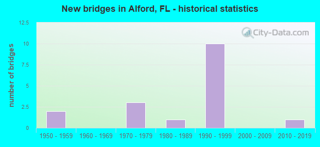
- New bridges - historical statistics
- 21950-1959
- 31970-1979
- 11980-1989
- 101990-1999
- 12010-2019


- Bridge Condition - Deck
- 50.0%Good
- 42.9%Satisfactory
- 7.1%Fair

- Bridge Condition - Superstructure
- 35.7%Good
- 50.0%Satisfactory
- 14.3%Poor

- Bridge Condition - Substructure
- 14.3%Good
- 50.0%Satisfactory
- 35.7%Fair

- Bridge Condition - Channel
- 6.7%Excellent
- 20.0%Good
- 53.3%Satisfactory
- 6.7%Fair
- 13.3%Poor
Find on map >> Show street view
Structure Number: 530027, Location: 1.5 Mi East of US231/SR75 (Lat: 30.699250, Lng: -85.368667), Route carried "on" structure: County highway 1656, Year Built: 1958, Status: Open, Structure Length: 1.54m (5.05ft), Average Daily Traffic: 900 (year 2020), Truck Traffic: 12%, Average Future Daily Traffic: 990 (year 2040), Design Load: HS 20, Features Intersected: Little Dry Creek
Minimum Vertical Clearance: 30+ m (98+ ft), Kilometerpoint: 6.674, Lanes on structure: 2, Owner: County Highway Agency, Approaching Roadway Width: 7.3m (24.0ft), Material/Design: Concrete, Design/Construction: Culvert, Number Of Spans In Main Unit: 4, Length of Maximum Span: 4.0m (13.1ft)
Condition: Channel: Poor, Culverts: Satisfactory, Operating Rating: 62.6 metric tons, Method Used To Determine Operating Rating: Load Factor (LF), Inventory Rating: 37.2 metric tons, Method Used To Determine Inventory Rating: Load Factor (LF), Structural Evaluation: Equal to present minimum criteria, Waterway Adequacy: Better than present minimum criteria, Approach Roadway Alignment: Equal to present minimum criteria, Designated Inspection Frequency: Every 24 months, Underwater Inspection Frequency: Every 12 months, Other Special Inspection Frequency: Every 12 months, Inspection Date: August 2020, Underwater Inspection Date: August 2021, Other Special Inspection Date: August 2021
Find on map >> Show street view
Structure Number: 530043, Location: 2.2 Mi West of US231/SR75 (Lat: 30.697450, Lng: -85.430033), Route carried "on" structure: County highway 276, Year Built: 1954, Status: Open, Structure Length: 1.30m (4.27ft), Average Daily Traffic: 1,300 (year 2019), Truck Traffic: 8%, Average Future Daily Traffic: 1,430 (year 2039), Design Load: HS 20, Features Intersected: Cypress Creek
Minimum Vertical Clearance: 30+ m (98+ ft), Kilometerpoint: 0.274, Lanes on structure: 2, Owner: County Highway Agency, Approaching Roadway Width: 7.2m (23.6ft), Material/Design: Concrete, Design/Construction: Culvert, Number Of Spans In Main Unit: 4, Length of Maximum Span: 3.4m (11.2ft)
Condition: Channel: Satisfactory, Culverts: Satisfactory, Operating Rating: 61.7 metric tons, Method Used To Determine Operating Rating: Load Factor (LF), Inventory Rating: 37.2 metric tons, Method Used To Determine Inventory Rating: Load Factor (LF), Structural Evaluation: Equal to present minimum criteria, Waterway Adequacy: Better than present minimum criteria, Approach Roadway Alignment: Equal to present desirable criteria, Designated Inspection Frequency: Every 24 months, Underwater Inspection Frequency: Every 24 months, Inspection Date: August 2020, Underwater Inspection Date: August 2020
Find on map >> Show street view
Structure Number: 530065, Location: 2.0 mi. W of US231,SR 75 (Lat: 30.747536, Lng: -85.415625), Route carried "on" structure: County highway 195, Year Built: 1976, Status: Open, Structure Length: 7.68m (25.20ft), Average Daily Traffic: 650 (year 2020), Truck Traffic: 17%, Average Future Daily Traffic: 1,128 (year 2042), Design Load: HS 20+Mod, Features Intersected: I10 SR8
Minimum Vertical Clearance: 30+ m (98+ ft), Kilometerpoint: 2.457, Lanes on structure: 2, Lanes under structure: 4, Owner: State Highway Agency, Approaching Roadway Width: 7.3m (24.0ft), Material/Design: Prestressed concrete, Design/Construction: Stringer/Multi-beam, Number Of Spans In Main Unit: 4, Length of Maximum Span: 27.0m (88.6ft), Curb-To-Curb Width: 13.4m (44.0ft), Out-to-Out Width: 14.1m (46.3ft)
Condition: Deck: Good, Superstructure: Good, Substructure: Good, Operating Rating: 66.2 metric tons, Method Used To Determine Operating Rating: Load Factor (LF), Inventory Rating: 39.9 metric tons, Method Used To Determine Inventory Rating: Load Factor (LF), Structural Evaluation: Better than present minimum criteria, Deck Geometry: Superior to present desirable criteria, Underclear: Somewhat better than minimum adequacy, Approach Roadway Alignment: Equal to present desirable criteria, Designated Inspection Frequency: Every 24 months, Inspection Date: August 2021, Deck Structure Type: Concrete Cast-file-Place
Find on map >> Show street view
Structure Number: 530098, Location: 4.3mi South of I10 SR8 (Lat: 30.689797, Lng: -85.392647), Route carried "on" structure: US 231, Year Built: 1985, Status: Open, Structure Length: 3.20m (10.50ft), Average Daily Traffic: 7,700 (year 2020), Truck Traffic: 24%, Average Future Daily Traffic: 13,360 (year 2042), Design Load: HS 20, Features Intersected: Stump Creek
Minimum Vertical Clearance: 30+ m (98+ ft), Kilometerpoint: 14.437, Lanes on structure: 4, Base Highway Network: Yes, Owner: State Highway Agency, Approaching Roadway Width: 19.5m (64.0ft), Skew: 20 degrees, Material/Design: Prestressed concrete, Design/Construction: Slab, Number Of Spans In Main Unit: 3, Length of Maximum Span: 10.7m (35.1ft), Curb or Sidewalk Widths: Left: 0.9m (3.0ft), Right: 0.9m (3.0ft), Curb-To-Curb Width: 20.7m (67.9ft), Out-to-Out Width: 21.9m (71.9ft)
Condition: Deck: Good, Superstructure: Good, Substructure: Satisfactory, Channel: Good, Operating Rating: 81.6 metric tons, Method Used To Determine Operating Rating: Load Factor (LF), Inventory Rating: 54.4 metric tons, Method Used To Determine Inventory Rating: Load Factor (LF), Structural Evaluation: Equal to present minimum criteria, Deck Geometry: Superior to present desirable criteria, Waterway Adequacy: Equal to present desirable criteria, Approach Roadway Alignment: Equal to present desirable criteria, Designated Inspection Frequency: Every 24 months, Underwater Inspection Frequency: Every 24 months, Inspection Date: July 2020, Underwater Inspection Date: July 2020, Deck Structure Type: Concrete Precast Panels, Wearing Surface/Protective System: Wearing Surface: Bituminous
Find on map >> Show street view
Structure Number: 534003, Location: 0.42 Miles North of CR276 (Lat: 30.701278, Lng: -85.431908), Route carried "on" structure: Other road , Year Built: 1991, Status: Posted for load, Structure Length: 1.72m (5.64ft), Average Daily Traffic: 48 (year 2020), Average Future Daily Traffic: 53 (year 2040), Design Load: HL 93, Features Intersected: Cypress Creek, Facility Carried by Structure: Cypress Creek Road
Minimum Vertical Clearance: 30+ m (98+ ft), Kilometerpoint: 0.089, Lanes on structure: 1, Owner: County Highway Agency, Approaching Roadway Width: 4.3m (14.1ft), Material/Design: Wood or Timber, Design/Construction: Stringer/Multi-beam, Number Of Spans In Main Unit: 5, Length of Maximum Span: 3.8m (12.5ft), Curb or Sidewalk Widths: Left: 0.2m (0.7ft), Right: 0.2m (0.7ft), Curb-To-Curb Width: 5.8m (19.0ft), Out-to-Out Width: 6.1m (20.0ft)
Condition: Deck: Satisfactory, Superstructure: Satisfactory, Substructure: Satisfactory, Channel: Poor, Operating Rating: 7.3 metric tons, Method Used To Determine Operating Rating: Load and Resistance Factor (LRFR), Inventory Rating: 5.4 metric tons, Method Used To Determine Inventory Rating: Load and Resistance Factor (LRFR), Structural Evaluation: High priority of corrective action, Deck Geometry: Meets minimum limits, Waterway Adequacy: Better than present minimum criteria, Approach Roadway Alignment: Equal to present desirable criteria, Bridge Posting: Required (Relationship of Operating Rating to Maximum Legal Load: > 39.9% below), Designated Inspection Frequency: Every 24 months, Other Special Inspection Frequency: Every 12 months, Inspection Date: June 2020, Other Special Inspection Date: June 2021, Deck Structure Type: Wood or Timber, Wearing Surface/Protective System: Wearing Surface: Wood or Timber
Find on map >> Show street view
Structure Number: 534013, Location: 0.3 Miles South of CR1656 (Lat: 30.689222, Lng: -85.388611), Route carried "on" structure: Other road , Year Built: 1991, Status: Open, Structure Length: 2.07m (6.79ft), Average Daily Traffic: 44 (year 2019), Average Future Daily Traffic: 48 (year 2039), Design Load: HS 20, Features Intersected: Stump Creek, Facility Carried by Structure: Tennessee Street
Minimum Vertical Clearance: 30+ m (98+ ft), Kilometerpoint: 2.531, Lanes on structure: 2, Owner: County Highway Agency, Approaching Roadway Width: 6.1m (20.0ft), Material/Design: Concrete, Design/Construction: Channel Beam, Number Of Spans In Main Unit: 2, Length of Maximum Span: 10.4m (34.1ft), Curb-To-Curb Width: 8.6m (28.2ft), Out-to-Out Width: 8.6m (28.2ft)
Condition: Deck: Good, Superstructure: Good, Substructure: Fair, Channel: Good, Operating Rating: 85.3 metric tons, Method Used To Determine Operating Rating: Load Factor (LF), Inventory Rating: 50.8 metric tons, Method Used To Determine Inventory Rating: Load Factor (LF), Structural Evaluation: Somewhat better than minimum adequacy, Deck Geometry: Better than present minimum criteria, Waterway Adequacy: Better than present minimum criteria, Approach Roadway Alignment: Equal to present desirable criteria, Designated Inspection Frequency: Every 24 months, Underwater Inspection Frequency: Every 24 months, Inspection Date: April 2021, Underwater Inspection Date: April 2021, Deck Structure Type: Concrete Precast Panels
Find on map >> Show street view
Structure Number: 534014, Location: 0.8 Miles South of CR 276 (Lat: 30.687250, Lng: -85.402194), Route carried "on" structure: Other road , Year Built: 1991, Status: Open, Structure Length: 2.07m (6.79ft), Average Daily Traffic: 44 (year 2019), Average Future Daily Traffic: 48 (year 2039), Design Load: HS 20, Features Intersected: Stump Creek, Facility Carried by Structure: Hudson Road
Minimum Vertical Clearance: 30+ m (98+ ft), Kilometerpoint: 2.189, Lanes on structure: 2, Owner: County Highway Agency, Approaching Roadway Width: 6.1m (20.0ft), Material/Design: Concrete, Design/Construction: Channel Beam, Number Of Spans In Main Unit: 2, Length of Maximum Span: 10.4m (34.1ft), Curb-To-Curb Width: 8.6m (28.2ft), Out-to-Out Width: 8.6m (28.2ft)
Condition: Deck: Good, Superstructure: Good, Substructure: Fair, Channel: Satisfactory, Operating Rating: 85.3 metric tons, Method Used To Determine Operating Rating: Load Factor (LF), Inventory Rating: 50.8 metric tons, Method Used To Determine Inventory Rating: Load Factor (LF), Structural Evaluation: Somewhat better than minimum adequacy, Deck Geometry: Better than present minimum criteria, Waterway Adequacy: Better than present minimum criteria, Approach Roadway Alignment: Equal to present desirable criteria, Designated Inspection Frequency: Every 24 months, Underwater Inspection Frequency: Every 24 months, Inspection Date: April 2021, Underwater Inspection Date: April 2021, Deck Structure Type: Concrete Precast Panels
Find on map >> Show street view
Structure Number: 534018, Location: 0.3 Miles South of CR1656 (Lat: 30.692564, Lng: -85.357792), Route carried "on" structure: Other road , Year Built: 1991, Status: Open, Structure Length: 2.19m (7.19ft), Average Daily Traffic: 78 (year 2019), Average Future Daily Traffic: 86 (year 2039), Design Load: HS 20, Features Intersected: Dry Creek, Facility Carried by Structure: Mill Road
Minimum Vertical Clearance: 30+ m (98+ ft), Kilometerpoint: 8.874, Lanes on structure: 2, Owner: County Highway Agency, Approaching Roadway Width: 5.5m (18.0ft), Material/Design: Concrete, Design/Construction: Channel Beam, Number Of Spans In Main Unit: 3, Length of Maximum Span: 7.3m (24.0ft), Curb-To-Curb Width: 8.6m (28.2ft), Out-to-Out Width: 8.6m (28.2ft)
Condition: Deck: Satisfactory, Superstructure: Satisfactory, Substructure: Fair, Channel: Satisfactory, Inventory Rating: 56.2 metric tons, Method Used To Determine Inventory Rating: Allowable Stress (AS), Structural Evaluation: Somewhat better than minimum adequacy, Deck Geometry: Better than present minimum criteria, Waterway Adequacy: Equal to present desirable criteria, Approach Roadway Alignment: Equal to present desirable criteria, Designated Inspection Frequency: Every 24 months, Underwater Inspection Frequency: Every 24 months, Inspection Date: April 2021, Underwater Inspection Date: April 2021, Deck Structure Type: Concrete Precast Panels
Find on map >> Show street view
Structure Number: 534022, Location: 0.3 Mi South of CR 1656 (Lat: 30.691222, Lng: -85.357833), Route carried "on" structure: Other road , Year Built: 1992, Status: Open, Structure Length: 4.88m (16.01ft), Average Daily Traffic: 55 (year 2020), Average Future Daily Traffic: 60 (year 2040), Features Intersected: Dry Creek, Facility Carried by Structure: Mill Road
Minimum Vertical Clearance: 30+ m (98+ ft), Kilometerpoint: 8.734, Lanes on structure: 2, Owner: County Highway Agency, Approaching Roadway Width: 7.3m (24.0ft), Material/Design: Concrete, Design/Construction: Channel Beam, Number Of Spans In Main Unit: 5, Length of Maximum Span: 10.4m (34.1ft), Curb-To-Curb Width: 8.6m (28.2ft), Out-to-Out Width: 8.6m (28.2ft)
Condition: Deck: Good, Superstructure: Satisfactory, Substructure: Satisfactory, Channel: Satisfactory, Operating Rating: 85.3 metric tons, Method Used To Determine Operating Rating: Load Factor (LF), Inventory Rating: 50.8 metric tons, Method Used To Determine Inventory Rating: Load Factor (LF), Structural Evaluation: Equal to present minimum criteria, Deck Geometry: Better than present minimum criteria, Waterway Adequacy: Better than present minimum criteria, Approach Roadway Alignment: Equal to present desirable criteria, Designated Inspection Frequency: Every 24 months, Underwater Inspection Frequency: Every 24 months, Inspection Date: May 2021, Underwater Inspection Date: May 2021, Deck Structure Type: Concrete Precast Panels
Find on map >> Show street view
Structure Number: 534025, Location: 0.8 Mi East of US231/SR75 (Lat: 30.721381, Lng: -85.375986), Route carried "on" structure: Other road , Year Built: 1992, Status: Open, Structure Length: 1.09m (3.58ft), Average Daily Traffic: 48 (year 2020), Average Future Daily Traffic: 53 (year 2040), Design Load: HL 93, Features Intersected: Little Dry Creek, Facility Carried by Structure: Rowell Road
Minimum Vertical Clearance: 30+ m (98+ ft), Kilometerpoint: 1.381, Lanes on structure: 1, Owner: County Highway Agency, Approaching Roadway Width: 4.6m (15.1ft), Material/Design: Wood or Timber, Design/Construction: Stringer/Multi-beam, Number Of Spans In Main Unit: 3, Length of Maximum Span: 4.0m (13.1ft), Curb or Sidewalk Widths: Left: 0.2m (0.7ft), Right: 0.2m (0.7ft), Curb-To-Curb Width: 5.8m (19.0ft), Out-to-Out Width: 6.2m (20.3ft)
Condition: Deck: Satisfactory, Superstructure: Satisfactory, Substructure: Satisfactory, Channel: Good, Operating Rating: 25.4 metric tons, Method Used To Determine Operating Rating: Load and Resistance Factor (LRFR), Inventory Rating: 20.0 metric tons, Method Used To Determine Inventory Rating: Load and Resistance Factor (LRFR), Structural Evaluation: Somewhat better than minimum adequacy, Deck Geometry: Meets minimum limits, Waterway Adequacy: Better than present minimum criteria, Approach Roadway Alignment: Equal to present desirable criteria, Designated Inspection Frequency: Every 24 months, Inspection Date: May 2021, Deck Structure Type: Wood or Timber, Wearing Surface/Protective System: Wearing Surface: Wood or Timber
Find on map >> Show street view
Structure Number: 534134, Location: 1.0 Mi S CR 276/Park Rd (Lat: 30.681700, Lng: -85.420914), Route carried "on" structure: Other road , Year Built: 1972, Status: Posted for load, Structure Length: 1.32m (4.33ft), Average Daily Traffic: 44 (year 2020), Average Future Daily Traffic: 48 (year 2040), Design Load: HL 93, Features Intersected: Stump Creek, Facility Carried by Structure: Grissett Road
Minimum Vertical Clearance: 30+ m (98+ ft), Kilometerpoint: 1.923, Lanes on structure: 1, Owner: County Highway Agency, Approaching Roadway Width: 3.7m (12.1ft), Material/Design: Wood or Timber, Design/Construction: Stringer/Multi-beam, Number Of Spans In Main Unit: 4, Length of Maximum Span: 3.5m (11.5ft), Curb or Sidewalk Widths: Left: 0.2m (0.7ft), Right: 0.2m (0.7ft), Curb-To-Curb Width: 4.0m (13.1ft), Out-to-Out Width: 4.3m (14.1ft)
Condition: Deck: Good, Superstructure: Poor, Substructure: Satisfactory, Channel: Satisfactory, Operating Rating: 3.9 metric tons, Method Used To Determine Operating Rating: Load and Resistance Factor (LRFR), Inventory Rating: 2.9 metric tons, Method Used To Determine Inventory Rating: Load and Resistance Factor (LRFR), Structural Evaluation: High priority of corrective action, Deck Geometry: Somewhat better than minimum adequacy, Waterway Adequacy: Better than present minimum criteria, Approach Roadway Alignment: Equal to present minimum criteria, Bridge Posting: Required (Relationship of Operating Rating to Maximum Legal Load: > 39.9% below), Designated Inspection Frequency: Every 24 months, Other Special Inspection Frequency: Every 12 months, Inspection Date: November 2021, Other Special Inspection Date: November 2021, Deck Structure Type: Wood or Timber, Wearing Surface/Protective System: Wearing Surface: Wood or Timber
Find on map >> Show street view
Structure Number: 534156, Location: 1.7 Mi East US231/SR75 (Lat: 30.660397, Lng: -85.368753), Route carried "on" structure: Other road , Year Built: 1994, Status: Open, Structure Length: 0.76m (2.49ft), Average Daily Traffic: 456 (year 2019), Average Future Daily Traffic: 791 (year 2039), Design Load: HL 93, Features Intersected: Shores Mill Creek, Facility Carried by Structure: Pilgrim Rest Ch Rd
Minimum Vertical Clearance: 30+ m (98+ ft), Kilometerpoint: 2.469, Lanes on structure: 1, Owner: County Highway Agency, Approaching Roadway Width: 4.9m (16.1ft), Material/Design: Wood or Timber, Design/Construction: Stringer/Multi-beam, Number Of Spans In Main Unit: 2, Length of Maximum Span: 4.0m (13.1ft), Curb or Sidewalk Widths: Left: 0.2m (0.7ft), Right: 0.2m (0.7ft), Curb-To-Curb Width: 5.8m (19.0ft), Out-to-Out Width: 6.1m (20.0ft)
Condition: Deck: Fair, Superstructure: Satisfactory, Substructure: Fair, Channel: Satisfactory, Operating Rating: 26.3 metric tons, Method Used To Determine Operating Rating: Load and Resistance Factor (LRFR), Inventory Rating: 20.0 metric tons, Method Used To Determine Inventory Rating: Load and Resistance Factor (LRFR), Structural Evaluation: Somewhat better than minimum adequacy, Deck Geometry: High priority of replacement, Waterway Adequacy: Better than present minimum criteria, Approach Roadway Alignment: Equal to present desirable criteria, Designated Inspection Frequency: Every 24 months, Underwater Inspection Frequency: Every 24 months, Inspection Date: May 2020, Underwater Inspection Date: May 2020, Deck Structure Type: Wood or Timber, Wearing Surface/Protective System: Wearing Surface: Wood or Timber
Find on map >> Show street view
Structure Number: 534168, Location: 1.5 Miles East US231/SR75 (Lat: 30.673067, Lng: -85.370419), Route carried "on" structure: Other road , Year Built: 1995, Status: Open, Structure Length: 1.46m (4.79ft), Average Daily Traffic: 66 (year 2019), Average Future Daily Traffic: 72 (year 2039), Features Intersected: Shores Mill Creek, Facility Carried by Structure: Mill Road
Minimum Vertical Clearance: 30+ m (98+ ft), Kilometerpoint: 6.275, Lanes on structure: 2, Owner: County Highway Agency, Approaching Roadway Width: 5.5m (18.0ft), Material/Design: Concrete, Design/Construction: Channel Beam, Number Of Spans In Main Unit: 2, Length of Maximum Span: 7.3m (24.0ft), Curb-To-Curb Width: 8.6m (28.2ft), Out-to-Out Width: 8.6m (28.2ft)
Condition: Deck: Good, Superstructure: Good, Substructure: Fair, Channel: Fair, Inventory Rating: 56.2 metric tons, Method Used To Determine Inventory Rating: Load Factor (LF), Structural Evaluation: Somewhat better than minimum adequacy, Deck Geometry: Better than present minimum criteria, Waterway Adequacy: Better than present minimum criteria, Approach Roadway Alignment: Equal to present minimum criteria, Designated Inspection Frequency: Every 24 months, Underwater Inspection Frequency: Every 24 months, Inspection Date: April 2021, Underwater Inspection Date: April 2021, Deck Structure Type: Concrete Precast Panels
Find on map >> Show street view
Structure Number: 534171, Location: 0.85 Mi East US231/SR75 (Lat: 30.734656, Lng: -85.372489), Route carried "on" structure: Other road , Year Built: 1998, Status: Posted for load, Structure Length: 1.39m (4.56ft), Average Daily Traffic: 50 (year 2020), Average Future Daily Traffic: 55 (year 2040), Features Intersected: Little Dry Creek, Facility Carried by Structure: Dock Road
Minimum Vertical Clearance: 30+ m (98+ ft), Kilometerpoint: 1.366, Lanes on structure: 1, Owner: County Highway Agency, Approaching Roadway Width: 4.0m (13.1ft), Material/Design: Wood or Timber, Design/Construction: Stringer/Multi-beam, Number Of Spans In Main Unit: 4, Length of Maximum Span: 3.8m (12.5ft), Curb or Sidewalk Widths: Left: 0.2m (0.7ft), Right: 0.2m (0.7ft), Curb-To-Curb Width: 5.8m (19.0ft), Out-to-Out Width: 6.2m (20.3ft)
Condition: Deck: Satisfactory, Superstructure: Poor, Substructure: Satisfactory, Channel: Satisfactory, Operating Rating: 8.8 metric tons, Method Used To Determine Operating Rating: Load and Resistance Factor (LRFR), Inventory Rating: 6.5 metric tons, Method Used To Determine Inventory Rating: Load and Resistance Factor (LRFR), Structural Evaluation: High priority of corrective action, Deck Geometry: Meets minimum limits, Waterway Adequacy: Better than present minimum criteria, Approach Roadway Alignment: Equal to present desirable criteria, Bridge Posting: Required (Relationship of Operating Rating to Maximum Legal Load: > 39.9% below), Designated Inspection Frequency: Every 24 months, Other Special Inspection Frequency: Every 12 months, Inspection Date: November 2021, Other Special Inspection Date: November 2021, Deck Structure Type: Wood or Timber, Wearing Surface/Protective System: Wearing Surface: Wood or Timber
Find on map >> Show street view
Structure Number: 534189, Location: 1.5 Miles East US231/SR75 (Lat: 30.709167, Lng: -85.373889), Route carried "on" structure: County highway , Year Built: 1995, Status: Open, Structure Length: 1.03m (3.38ft), Average Daily Traffic: 55 (year 2020), Average Future Daily Traffic: 60 (year 2040), Design Load: HS 20, Features Intersected: Little Dry Creek, Facility Carried by Structure: Holley Timber Road
Minimum Vertical Clearance: 30+ m (98+ ft), Kilometerpoint: 2.380, Lanes on structure: 2, Owner: County Highway Agency, Approaching Roadway Width: 6.1m (20.0ft), Material/Design: Concrete, Design/Construction: Channel Beam, Number Of Spans In Main Unit: 1, Length of Maximum Span: 10.3m (33.8ft), Curb-To-Curb Width: 9.7m (31.8ft), Out-to-Out Width: 9.7m (31.8ft)
Condition: Deck: Satisfactory, Superstructure: Satisfactory, Substructure: Satisfactory, Channel: Satisfactory, Operating Rating: 81.6 metric tons, Method Used To Determine Operating Rating: Load Factor (LF), Inventory Rating: 49.0 metric tons, Method Used To Determine Inventory Rating: Load Factor (LF), Structural Evaluation: Equal to present minimum criteria, Deck Geometry: Better than present minimum criteria, Waterway Adequacy: Better than present minimum criteria, Approach Roadway Alignment: Equal to present minimum criteria, Designated Inspection Frequency: Every 24 months, Underwater Inspection Frequency: Every 24 months, Inspection Date: October 2021, Underwater Inspection Date: October 2021, Deck Structure Type: Concrete Precast Panels
Find on map >> Show street view
Structure Number: 614164, Location: 0.6 Mi S of Corbin Rd (Lat: 30.720575, Lng: -85.437097), Route carried "on" structure: County highway , Year Built: 2011, Status: Posted for load, Structure Length: 0.92m (3.02ft), Average Daily Traffic: 150 (year 2020), Truck Traffic: 1%, Average Future Daily Traffic: 260 (year 2042), Design Load: HL 93, Features Intersected: Bellamy Bay Branch, Facility Carried by Structure: Rudd Road
Minimum Vertical Clearance: 30+ m (98+ ft), Kilometerpoint: 2.412, Lanes on structure: 1, Owner: County Highway Agency, Approaching Roadway Width: 4.6m (15.1ft), Material/Design: Wood or Timber, Design/Construction: Stringer/Multi-beam, Number Of Spans In Main Unit: 2, Length of Maximum Span: 4.6m (15.1ft), Curb-To-Curb Width: 4.9m (16.1ft), Out-to-Out Width: 4.9m (16.1ft)
Condition: Deck: Satisfactory, Superstructure: Satisfactory, Substructure: Good, Channel: Excellent, Operating Rating: 15.4 metric tons, Method Used To Determine Operating Rating: Load and Resistance Factor (LRFR), Inventory Rating: 11.8 metric tons, Method Used To Determine Inventory Rating: Load and Resistance Factor (LRFR), Structural Evaluation: Meets minimum limits, Deck Geometry: High priority of replacement, Waterway Adequacy: Better than present minimum criteria, Approach Roadway Alignment: Equal to present desirable criteria, Bridge Posting: Required (Relationship of Operating Rating to Maximum Legal Load: > 39.9% below), Designated Inspection Frequency: Every 24 months, Other Special Inspection Frequency: Every 12 months, Inspection Date: December 2021, Other Special Inspection Date: December 2021, Deck Structure Type: Wood or Timber
Find on map >> Show street view
Structure Number: 530065, Location: 2.0 mi. W of US231,SR 75 (Lat: 30.747536, Lng: -85.415625), Route carried "under" structure: Interstate 10, Year Built: 1976, Structure Length: 0. m, Average Daily Traffic: 16,806 (year 2020), Truck Traffic: 33%, Features Intersected: I10 SR8, Facility Carried by Structure: CR195
Minimum Vertical Clearance: 4.97m (16.31ft), Kilometerpoint: 1.619, Lanes on structure: 2, Lanes under structure: 4, Material/Design: Prestressed concrete, Design/Construction: Stringer/Multi-beam, Length of Maximum Span: 27.0m (88.6ft)