Bridge Statistics for Alachua, Florida (FL)
Condition, Traffic, Stress, Structural Evaluation, Project Costs
- National Bridge Inventory (NBI) Statistics
- 32Number of bridges
- 1,430ft / 436mTotal length
- $18,000,000Total costs
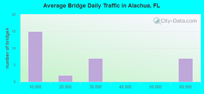
- 675,343Total average daily traffic
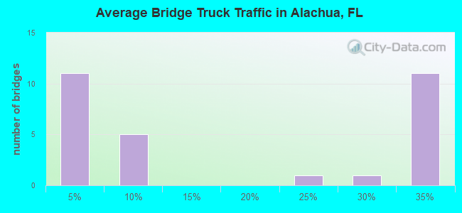
- 187,149Total average daily truck traffic
- National Bridge Inventory (NBI) Registered Bridges for Alachua
- No street view available for this location
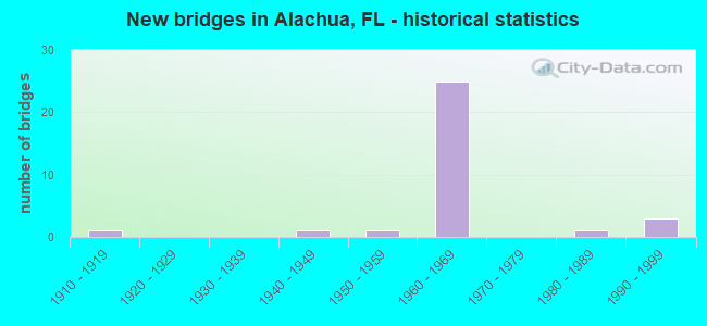
- New bridges - historical statistics
- 11910-1919
- 11940-1949
- 11950-1959
- 251960-1969
- 11980-1989
- 31990-1999
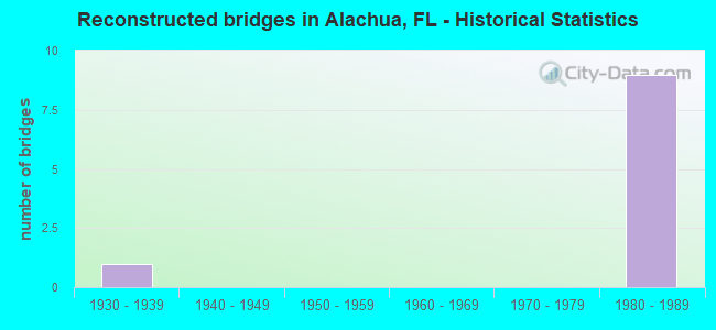
- Reconstructed bridges - Historical Statistics
- 11930-1939
- 01940-1949
- 01950-1959
- 01960-1969
- 01970-1979
- 91980-1989
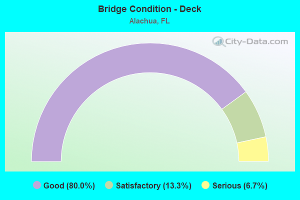
- Bridge Condition - Deck
- 80.0%Good
- 13.3%Satisfactory
- 6.7%Serious
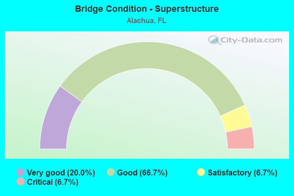
- Bridge Condition - Superstructure
- 20.0%Very good
- 66.7%Good
- 6.7%Satisfactory
- 6.7%Critical
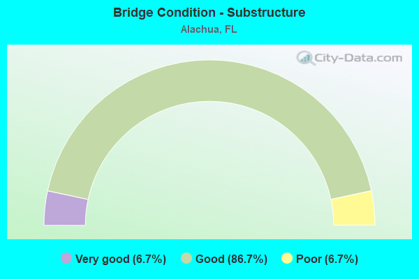
- Bridge Condition - Substructure
- 6.7%Very good
- 86.7%Good
- 6.7%Poor
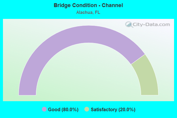
- Bridge Condition - Channel
- 80.0%Good
- 20.0%Satisfactory
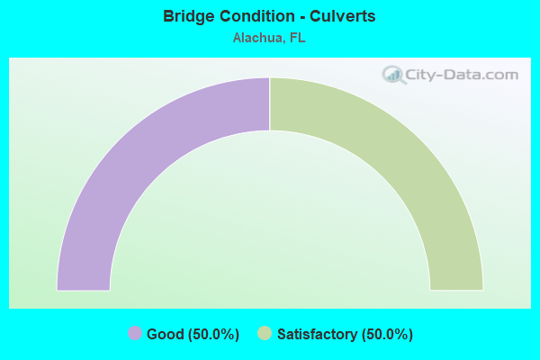
- Bridge Condition - Culverts
- 50.0%Good
- 50.0%Satisfactory
Find on map >> Show street view
Structure Number: 260002, Location: 5.4 MI. N OF US-441 (Lat: 29.874214, Lng: -82.542394), Route carried "on" structure: County highway 236, Year Built: 1963, Status: Open, Structure Length: 8.23m (27.00ft), Average Daily Traffic: 4,000 (year 2020), Truck Traffic: 3%, Average Future Daily Traffic: 6,940 (year 2042), Design Load: H 20, Features Intersected: I-75 (SR-93)
Minimum Vertical Clearance: 30+ m (98+ ft), Kilometerpoint: 7.187, Lanes on structure: 2, Lanes under structure: 6, Owner: State Highway Agency, Approaching Roadway Width: 6.5m (21.3ft), Skew: 3 degrees, Material/Design: Prestressed concrete, Design/Construction: Stringer/Multi-beam, Number Of Spans In Main Unit: 4, Length of Maximum Span: 24.7m (81.0ft), Curb-To-Curb Width: 8.5m (27.9ft), Out-to-Out Width: 10.4m (34.1ft)
Condition: Deck: Satisfactory, Superstructure: Good, Substructure: Good, Operating Rating: 51.6 metric tons, Method Used To Determine Operating Rating: Load Factor (LF), Inventory Rating: 40.5 metric tons, Method Used To Determine Inventory Rating: Load Factor (LF), Structural Evaluation: Better than present minimum criteria, Deck Geometry: Meets minimum limits, Underclear: High priority of corrective action, Approach Roadway Alignment: Equal to present desirable criteria, Designated Inspection Frequency: Every 24 months, Inspection Date: November 2020, Deck Structure Type: Concrete Cast-file-Place
Find on map >> Show street view
Structure Number: 260004, Location: CITY OF ALACHUA (Lat: 29.787500, Lng: -82.477778), Route carried "on" structure: US 441, Year Built: 1964, Year Reconstructed: 1992, Status: Open, Structure Length: 12.28m (40.29ft), Average Daily Traffic: 8,850 (year 2020), Truck Traffic: 6%, Average Future Daily Traffic: 15,355 (year 2042), Design Load: H 20, Features Intersected: CR-2054 & CSXRR
Minimum Vertical Clearance: 30+ m (98+ ft), Kilometerpoint: 27.050, Lanes on structure: 2, Lanes under structure: 2, Base Highway Network: Yes, Owner: State Highway Agency, Approaching Roadway Width: 10.8m (35.4ft), Skew: 9 degrees, Material/Design: Prestressed concrete, Design/Construction: Stringer/Multi-beam, Number Of Spans In Main Unit: 6, Length of Maximum Span: 26.2m (86.0ft), Curb-To-Curb Width: 11.1m (36.4ft), Out-to-Out Width: 12.1m (39.7ft)
Condition: Deck: Good, Superstructure: Good, Substructure: Good, Operating Rating: 42.2 metric tons, Method Used To Determine Operating Rating: Load Factor (LF), Inventory Rating: 25.3 metric tons, Method Used To Determine Inventory Rating: Load Factor (LF), Structural Evaluation: Equal to present minimum criteria, Deck Geometry: Equal to present minimum criteria, Underclear: High priority of corrective action, Approach Roadway Alignment: Equal to present desirable criteria, Designated Inspection Frequency: Every 24 months, Inspection Date: March 2021, Deck Structure Type: Concrete Cast-file-Place
Find on map >> Show street view
Structure Number: 26005, Location: 1.8 MI. N. OF SR-222 (Lat: 29.716264, Lng: -82.465858), Route carried "on" structure: County highway 232, Year Built: 1963, Status: Open, Structure Length: 9.54m (31.30ft), Average Daily Traffic: 3,400 (year 2020), Truck Traffic: 3%, Average Future Daily Traffic: 5,899 (year 2042), Design Load: H 20, Features Intersected: I-75 SR-93
Minimum Vertical Clearance: 30+ m (98+ ft), Kilometerpoint: 19.648, Lanes on structure: 2, Lanes under structure: 6, Owner: State Highway Agency, Approaching Roadway Width: 10.4m (34.1ft), Skew: 4 degrees, Material/Design: Prestressed concrete, Design/Construction: Stringer/Multi-beam, Number Of Spans In Main Unit: 4, Length of Maximum Span: 30.8m (101.0ft), Curb or Sidewalk Widths: Left: 0.6m (2.0ft), Right: 0.6m (2.0ft), Curb-To-Curb Width: 8.5m (27.9ft), Out-to-Out Width: 10.4m (34.1ft)
Condition: Deck: Good, Superstructure: Good, Substructure: Very good, Operating Rating: 51.9 metric tons, Method Used To Determine Operating Rating: Load Factor (LF), Inventory Rating: 34.6 metric tons, Method Used To Determine Inventory Rating: Load Factor (LF), Structural Evaluation: Better than present minimum criteria, Deck Geometry: Meets minimum limits, Underclear: Somewhat better than minimum adequacy, Approach Roadway Alignment: Equal to present desirable criteria, Designated Inspection Frequency: Every 24 months, Inspection Date: May 2021, Deck Structure Type: Concrete Cast-file-Place
Find on map >> Show street view
Structure Number: 26006, Location: 1.5 MI. S. OF US-441 (Lat: 29.779772, Lng: -82.511306), Route carried "on" structure: Interstate 75, Year Built: 1963, Year Reconstructed: 1994, Status: Open, Structure Length: 5.33m (17.49ft), Average Daily Traffic: 28,000 (year 2020), Truck Traffic: 34%, Average Future Daily Traffic: 48,580 (year 2042), Design Load: HS 20, Features Intersected: CR-2054 PEGGY ROAD
Minimum Vertical Clearance: 30+ m (98+ ft), Kilometerpoint: 39.582, Lanes on structure: 3, Lanes under structure: 2, Base Highway Network: Yes, Owner: State Highway Agency, Approaching Roadway Width: 17.4m (57.1ft), Material/Design: Prestressed concrete, Design/Construction: Stringer/Multi-beam, Number Of Spans In Main Unit: 4, Length of Maximum Span: 14.0m (45.9ft), Curb-To-Curb Width: 17.1m (56.1ft), Out-to-Out Width: 18.0m (59.1ft)
Condition: Deck: Good, Superstructure: Good, Substructure: Good, Operating Rating: 61.0 metric tons, Method Used To Determine Operating Rating: Load Factor (LF), Inventory Rating: 37.3 metric tons, Method Used To Determine Inventory Rating: Load Factor (LF), Structural Evaluation: Better than present minimum criteria, Deck Geometry: Equal to present minimum criteria, Underclear: High priority of corrective action, Approach Roadway Alignment: Equal to present desirable criteria, Designated Inspection Frequency: Every 24 months, Inspection Date: July 2021, Deck Structure Type: Concrete Cast-file-Place
Find on map >> Show street view
Structure Number: 260064, Location: 2 MI S OF CR-235 (Lat: 29.753278, Lng: -82.493419), Route carried "on" structure: County highway 241, Year Built: 1963, Status: Open, Structure Length: 12.04m (39.50ft), Average Daily Traffic: 11,000 (year 2020), Truck Traffic: 3%, Average Future Daily Traffic: 19,085 (year 2042), Design Load: H 20, Features Intersected: I-75 (SR-93)
Minimum Vertical Clearance: 30+ m (98+ ft), Kilometerpoint: 10.997, Lanes on structure: 2, Lanes under structure: 6, Owner: State Highway Agency, Approaching Roadway Width: 9.8m (32.2ft), Skew: 4 degrees, Material/Design: Prestressed concrete, Design/Construction: Stringer/Multi-beam, Number Of Spans In Main Unit: 4, Length of Maximum Span: 31.1m (102.0ft), Curb or Sidewalk Widths: Left: 0.6m (2.0ft), Right: 0.6m (2.0ft), Curb-To-Curb Width: 8.5m (27.9ft), Out-to-Out Width: 10.4m (34.1ft)
Condition: Deck: Satisfactory, Superstructure: Good, Substructure: Good, Operating Rating: 41.1 metric tons, Method Used To Determine Operating Rating: Load and Resistance Factor (LRFR), Inventory Rating: 17.1 metric tons, Method Used To Determine Inventory Rating: Load and Resistance Factor (LRFR), Structural Evaluation: Meets minimum limits, Deck Geometry: Meets minimum limits, Underclear: Meets minimum limits, Approach Roadway Alignment: Equal to present desirable criteria, Designated Inspection Frequency: Every 24 months, Inspection Date: April 2021, Deck Structure Type: Concrete Cast-file-Place
Find on map >> Show street view
Structure Number: 260065, Location: I-75 SB OVER US-441 (Lat: 29.801739, Lng: -82.514044), Route carried "on" structure: Interstate 75, Year Built: 1963, Year Reconstructed: 1994, Status: Open, Structure Length: 8.02m (26.31ft), Average Daily Traffic: 56,000 (year 2020), Truck Traffic: 34%, Average Future Daily Traffic: 97,160 (year 2042), Design Load: HS 20+Mod, Features Intersected: US-441 SR-25
Minimum Vertical Clearance: 30+ m (98+ ft), Kilometerpoint: 42.057, Lanes on structure: 4, Lanes under structure: 5, Base Highway Network: Yes, Owner: State Highway Agency, Approaching Roadway Width: 24.9m (81.7ft), Material/Design: Prestressed concrete, Design/Construction: Stringer/Multi-beam, Number Of Spans In Main Unit: 4, Length of Maximum Span: 20.7m (67.9ft), Curb-To-Curb Width: 19.6m (64.3ft), Out-to-Out Width: 20.5m (67.3ft)
Condition: Deck: Good, Superstructure: Good, Substructure: Good, Operating Rating: 54.4 metric tons, Method Used To Determine Operating Rating: Load Testing, Inventory Rating: 32.7 metric tons, Method Used To Determine Inventory Rating: Load Testing, Structural Evaluation: Better than present minimum criteria, Deck Geometry: Somewhat better than minimum adequacy, Underclear: Meets minimum limits, Approach Roadway Alignment: Equal to present desirable criteria, Designated Inspection Frequency: Every 24 months, Inspection Date: July 2021, Deck Structure Type: Concrete Cast-file-Place
Find on map >> Show street view
Structure Number: 260066, Location: 3 MI. N. OF US-441 (Lat: 29.838881, Lng: -82.527964), Route carried "on" structure: County highway 235A, Year Built: 1963, Status: Open, Structure Length: 7.62m (25.00ft), Average Daily Traffic: 5,000 (year 2020), Truck Traffic: 24%, Average Future Daily Traffic: 8,675 (year 2042), Design Load: H 20, Features Intersected: I-75 SR-93
Minimum Vertical Clearance: 30+ m (98+ ft), Kilometerpoint: 8.979, Lanes on structure: 2, Lanes under structure: 6, Owner: State Highway Agency, Approaching Roadway Width: 7.2m (23.6ft), Skew: 3 degrees, Material/Design: Prestressed concrete, Design/Construction: Stringer/Multi-beam, Number Of Spans In Main Unit: 4, Length of Maximum Span: 24.1m (79.1ft), Curb or Sidewalk Widths: Left: 0.5m (1.6ft), Right: 0.5m (1.6ft), Curb-To-Curb Width: 7.2m (23.6ft), Out-to-Out Width: 8.9m (29.2ft)
Condition: Deck: Good, Superstructure: Good, Substructure: Good, Operating Rating: 45.0 metric tons, Method Used To Determine Operating Rating: Load Factor (LF), Inventory Rating: 37.9 metric tons, Method Used To Determine Inventory Rating: Load Factor (LF), Structural Evaluation: Better than present minimum criteria, Deck Geometry: High priority of replacement, Underclear: High priority of corrective action, Approach Roadway Alignment: Equal to present desirable criteria, Designated Inspection Frequency: Every 24 months, Inspection Date: July 2021, Deck Structure Type: Concrete Cast-file-Place
Find on map >> Show street view
Structure Number: 260067, Location: 0.1 Mi. S OF US-441 (Lat: 29.799986, Lng: -82.514028), Route carried "on" structure: Interstate 75, Year Built: 1963, Year Reconstructed: 1994, Status: Open, Structure Length: 3.69m (12.11ft), Average Daily Traffic: 56,000 (year 2020), Truck Traffic: 34%, Average Future Daily Traffic: 97,160 (year 2042), Design Load: HS 20, Features Intersected: SCLRR REMOVED
Minimum Vertical Clearance: 30+ m (98+ ft), Kilometerpoint: 41.886, Lanes on structure: 3, Base Highway Network: Yes, Owner: State Highway Agency, Approaching Roadway Width: 17.0m (55.8ft), Material/Design: Prestressed concrete, Design/Construction: Stringer/Multi-beam, Number Of Spans In Main Unit: 3, Length of Maximum Span: 13.1m (43.0ft), Curb-To-Curb Width: 17.0m (55.8ft), Out-to-Out Width: 17.9m (58.7ft)
Condition: Deck: Good, Superstructure: Good, Substructure: Good, Operating Rating: 54.4 metric tons, Method Used To Determine Operating Rating: Load Testing, Inventory Rating: 32.7 metric tons, Method Used To Determine Inventory Rating: Load Testing, Structural Evaluation: Better than present minimum criteria, Deck Geometry: Equal to present minimum criteria, Approach Roadway Alignment: Equal to present desirable criteria, Designated Inspection Frequency: Every 24 months, Inspection Date: September 2021, Deck Structure Type: Concrete Cast-file-Place
Find on map >> Show street view
Structure Number: 260068, Location: 2 MI. S. OF US-441 (Lat: 29.775197, Lng: -82.509447), Route carried "on" structure: Interstate 75, Year Built: 1963, Year Reconstructed: 1994, Status: Open, Structure Length: 8.32m (27.30ft), Average Daily Traffic: 28,000 (year 2020), Truck Traffic: 34%, Average Future Daily Traffic: 48,580 (year 2042), Design Load: HS 20, Features Intersected: CR-235 & CSX RR
Minimum Vertical Clearance: 30+ m (98+ ft), Kilometerpoint: 39.002, Lanes on structure: 3, Lanes under structure: 2, Base Highway Network: Yes, Owner: State Highway Agency, Approaching Roadway Width: 18.2m (59.7ft), Skew: 2 degrees, Material/Design: Prestressed concrete, Design/Construction: Stringer/Multi-beam, Number Of Spans In Main Unit: 5, Length of Maximum Span: 17.7m (58.1ft), Curb-To-Curb Width: 17.0m (55.8ft), Out-to-Out Width: 18.0m (59.1ft)
Condition: Deck: Good, Superstructure: Very good, Substructure: Good, Operating Rating: 49.1 metric tons, Method Used To Determine Operating Rating: Load Factor (LF), Inventory Rating: 29.4 metric tons, Method Used To Determine Inventory Rating: Load Factor (LF), Structural Evaluation: Better than present minimum criteria, Deck Geometry: Equal to present minimum criteria, Underclear: Somewhat better than minimum adequacy, Approach Roadway Alignment: Equal to present desirable criteria, Designated Inspection Frequency: Every 24 months, Inspection Date: March 2021, Deck Structure Type: Concrete Cast-file-Place
Find on map >> Show street view
Structure Number: 260069, Location: 1.5 MI. S. OF US-441 (Lat: 29.779689, Lng: -82.511492), Route carried "on" structure: Interstate 75, Year Built: 1963, Year Reconstructed: 1994, Status: Open, Structure Length: 5.33m (17.49ft), Average Daily Traffic: 56,000 (year 2020), Truck Traffic: 34%, Average Future Daily Traffic: 97,160 (year 2042), Design Load: HS 20, Features Intersected: CR-2054 PEGGY ROAD
Minimum Vertical Clearance: 30+ m (98+ ft), Kilometerpoint: 39.582, Lanes on structure: 3, Lanes under structure: 2, Base Highway Network: Yes, Owner: State Highway Agency, Approaching Roadway Width: 17.7m (58.1ft), Material/Design: Prestressed concrete, Design/Construction: Stringer/Multi-beam, Number Of Spans In Main Unit: 4, Length of Maximum Span: 14.0m (45.9ft), Curb-To-Curb Width: 17.1m (56.1ft), Out-to-Out Width: 18.0m (59.1ft)
Condition: Deck: Good, Superstructure: Satisfactory, Substructure: Good, Operating Rating: 61.0 metric tons, Method Used To Determine Operating Rating: Load Factor (LF), Inventory Rating: 37.3 metric tons, Method Used To Determine Inventory Rating: Load Factor (LF), Structural Evaluation: Equal to present minimum criteria, Deck Geometry: Equal to present minimum criteria, Underclear: High priority of corrective action, Approach Roadway Alignment: Equal to present desirable criteria, Designated Inspection Frequency: Every 24 months, Inspection Date: July 2021, Deck Structure Type: Concrete Cast-file-Place
Find on map >> Show street view
Structure Number: 26007, Location: 0.1 Mi. S OF US-441 (Lat: 29.799989, Lng: -82.514303), Route carried "on" structure: Interstate 75, Year Built: 1963, Year Reconstructed: 1994, Status: Open, Structure Length: 3.69m (12.11ft), Average Daily Traffic: 56,000 (year 2020), Truck Traffic: 34%, Average Future Daily Traffic: 97,160 (year 2042), Design Load: HS 20, Features Intersected: SCLRR (REMOVED)
Minimum Vertical Clearance: 30+ m (98+ ft), Kilometerpoint: 41.886, Lanes on structure: 4, Base Highway Network: Yes, Owner: State Highway Agency, Approaching Roadway Width: 19.5m (64.0ft), Material/Design: Prestressed concrete, Design/Construction: Stringer/Multi-beam, Number Of Spans In Main Unit: 3, Length of Maximum Span: 13.1m (43.0ft), Curb-To-Curb Width: 19.5m (64.0ft), Out-to-Out Width: 20.3m (66.6ft)
Condition: Deck: Good, Superstructure: Good, Substructure: Good, Operating Rating: 47.0 metric tons, Method Used To Determine Operating Rating: Load Factor (LF), Inventory Rating: 28.1 metric tons, Method Used To Determine Inventory Rating: Load Factor (LF), Structural Evaluation: Better than present minimum criteria, Deck Geometry: Somewhat better than minimum adequacy, Approach Roadway Alignment: Equal to present desirable criteria, Designated Inspection Frequency: Every 24 months, Inspection Date: September 2021, Deck Structure Type: Concrete Cast-file-Place
Find on map >> Show street view
Structure Number: 260071, Location: 2 MI. S. OF US-441 (Lat: 29.775292, Lng: -82.509236), Route carried "on" structure: Interstate 75, Year Built: 1963, Year Reconstructed: 1994, Status: Open, Structure Length: 8.32m (27.30ft), Average Daily Traffic: 28,000 (year 2020), Truck Traffic: 34%, Average Future Daily Traffic: 48,580 (year 2042), Design Load: HS 20, Features Intersected: CR-235 & CSX RR
Minimum Vertical Clearance: 30+ m (98+ ft), Kilometerpoint: 39.022, Lanes on structure: 3, Lanes under structure: 2, Base Highway Network: Yes, Owner: State Highway Agency, Approaching Roadway Width: 17.6m (57.7ft), Skew: 2 degrees, Material/Design: Prestressed concrete, Design/Construction: Stringer/Multi-beam, Number Of Spans In Main Unit: 5, Length of Maximum Span: 17.7m (58.1ft), Curb-To-Curb Width: 17.1m (56.1ft), Out-to-Out Width: 18.0m (59.1ft)
Condition: Deck: Good, Superstructure: Very good, Substructure: Good, Operating Rating: 54.4 metric tons, Method Used To Determine Operating Rating: Load Testing, Inventory Rating: 32.7 metric tons, Method Used To Determine Inventory Rating: Load Testing, Structural Evaluation: Better than present minimum criteria, Deck Geometry: Equal to present minimum criteria, Underclear: Equal to present minimum criteria, Approach Roadway Alignment: Equal to present desirable criteria, Designated Inspection Frequency: Every 24 months, Inspection Date: March 2021, Deck Structure Type: Concrete Cast-file-Place
Find on map >> Show street view
Structure Number: 260073, Location: I-75 NB OVER US-441 (Lat: 29.801667, Lng: -82.513889), Route carried "on" structure: Interstate 75, Year Built: 1963, Year Reconstructed: 1994, Status: Open, Structure Length: 8.02m (26.31ft), Average Daily Traffic: 56,000 (year 2020), Truck Traffic: 34%, Average Future Daily Traffic: 97,160 (year 2042), Design Load: HS 20, Features Intersected: US-441 SR-25
Minimum Vertical Clearance: 30+ m (98+ ft), Kilometerpoint: 42.057, Lanes on structure: 4, Lanes under structure: 5, Base Highway Network: Yes, Owner: State Highway Agency, Approaching Roadway Width: 17.1m (56.1ft), Material/Design: Prestressed concrete, Design/Construction: Stringer/Multi-beam, Number Of Spans In Main Unit: 4, Length of Maximum Span: 20.7m (67.9ft), Curb-To-Curb Width: 19.6m (64.3ft), Out-to-Out Width: 20.5m (67.3ft)
Condition: Deck: Good, Superstructure: Good, Substructure: Good, Operating Rating: 54.4 metric tons, Method Used To Determine Operating Rating: Load Testing, Inventory Rating: 32.7 metric tons, Method Used To Determine Inventory Rating: Load Testing, Structural Evaluation: Better than present minimum criteria, Deck Geometry: Somewhat better than minimum adequacy, Underclear: Meets minimum limits, Approach Roadway Alignment: Equal to present desirable criteria, Designated Inspection Frequency: Every 24 months, Inspection Date: July 2021, Deck Structure Type: Concrete Cast-file-Place
Find on map >> Show street view
Structure Number: 260087, Location: 1.4 MI N OF SR 235 (Lat: 29.821111, Lng: -82.493611), Route carried "on" structure: County highway 241, Year Built: 1955, Status: Open, Structure Length: 0.63m (2.07ft), Average Daily Traffic: 2,800 (year 2021), Truck Traffic: 3%, Average Future Daily Traffic: 4,858 (year 2042), Design Load: HS 20, Features Intersected: BRANCH OF ROCKY CREEK
Minimum Vertical Clearance: 30+ m (98+ ft), Kilometerpoint: 2.221, Lanes on structure: 2, Owner: County Highway Agency, Approaching Roadway Width: 9.8m (32.2ft), Material/Design: Concrete, Design/Construction: Culvert, Number Of Spans In Main Unit: 2, Length of Maximum Span: 3.2m (10.5ft)
Condition: Channel: Good, Culverts: Satisfactory, Inventory Rating: 58.1 metric tons, Method Used To Determine Inventory Rating: Load Factor (LF), Structural Evaluation: Equal to present minimum criteria, Waterway Adequacy: Equal to present desirable criteria, Approach Roadway Alignment: Equal to present desirable criteria, Designated Inspection Frequency: Every 24 months, Inspection Date: November 2021
Find on map >> Show street view
Structure Number: 260088, Location: 1.8 MI S OF CR 236 (Lat: 29.854167, Lng: -82.492500), Route carried "on" structure: County highway 241, Year Built: 1941, Status: Open, Structure Length: 0.63m (2.07ft), Average Daily Traffic: 2,800 (year 2021), Truck Traffic: 3%, Average Future Daily Traffic: 4,858 (year 2042), Design Load: HS 20, Features Intersected: MILL CREEK
Minimum Vertical Clearance: 30+ m (98+ ft), Kilometerpoint: 5.848, Lanes on structure: 2, Owner: County Highway Agency, Approaching Roadway Width: 9.8m (32.2ft), Material/Design: Concrete, Design/Construction: Culvert, Number Of Spans In Main Unit: 2, Length of Maximum Span: 3.1m (10.2ft)
Condition: Channel: Good, Culverts: Satisfactory, Operating Rating: 63.1 metric tons, Method Used To Determine Operating Rating: Load Factor (LF), Inventory Rating: 37.9 metric tons, Method Used To Determine Inventory Rating: Load Factor (LF), Structural Evaluation: Equal to present minimum criteria, Waterway Adequacy: Better than present minimum criteria, Approach Roadway Alignment: Equal to present desirable criteria, Designated Inspection Frequency: Every 24 months, Inspection Date: November 2021
Find on map >> Show street view
Structure Number: 260102, Location: CITY OF ALACHUA (Lat: 29.787597, Lng: -82.477664), Route carried "on" structure: US 441, Year Built: 1992, Status: Open, Structure Length: 12.83m (42.09ft), Average Daily Traffic: 8,850 (year 2020), Truck Traffic: 6%, Average Future Daily Traffic: 15,355 (year 2042), Design Load: HS 20, Features Intersected: CR-2054 & CSXRR
Minimum Vertical Clearance: 30+ m (98+ ft), Kilometerpoint: 27.040, Lanes on structure: 2, Lanes under structure: 2, Base Highway Network: Yes, Owner: State Highway Agency, Approaching Roadway Width: 9.4m (30.8ft), Skew: 9 degrees, Material/Design: Prestressed concrete, Design/Construction: Stringer/Multi-beam, Number Of Spans In Main Unit: 6, Length of Maximum Span: 26.2m (86.0ft), Curb-To-Curb Width: 11.1m (36.4ft), Out-to-Out Width: 12.1m (39.7ft)
Condition: Deck: Good, Superstructure: Very good, Substructure: Good, Operating Rating: 50.3 metric tons, Method Used To Determine Operating Rating: Load Factor (LF), Inventory Rating: 32.0 metric tons, Method Used To Determine Inventory Rating: Load Factor (LF), Structural Evaluation: Better than present minimum criteria, Deck Geometry: Equal to present minimum criteria, Underclear: Meets minimum limits, Approach Roadway Alignment: Equal to present desirable criteria, Designated Inspection Frequency: Every 24 months, Inspection Date: March 2021, Deck Structure Type: Concrete Cast-file-Place
Find on map >> Show street view
Structure Number: 264143, Location: 1.2 MI S OF US 441 (Lat: 29.746875, Lng: -82.406819), Route carried "on" structure: City street , Year Built: 1989, Status: Open, Structure Length: 0.77m (2.53ft), Average Daily Traffic: 31 (year 2021), Average Future Daily Traffic: 54 (year 2042), Features Intersected: TURKEY CREEK, Facility Carried by Structure: NW 59TH TERRACE
Minimum Vertical Clearance: 30+ m (98+ ft), Kilometerpoint: 0.000, Lanes on structure: 2, Owner: City or Municipal Highway Agency, Approaching Roadway Width: 6.3m (20.7ft), Material/Design: Concrete, Design/Construction: Culvert, Number Of Spans In Main Unit: 2, Length of Maximum Span: 3.8m (12.5ft)
Condition: Channel: Satisfactory, Culverts: Good, Operating Rating: 82.3 metric tons, Method Used To Determine Operating Rating: Load and Resistance Factor (LRFR), Inventory Rating: 52.9 metric tons, Method Used To Determine Inventory Rating: Load and Resistance Factor (LRFR), Structural Evaluation: Better than present minimum criteria, Waterway Adequacy: Somewhat better than minimum adequacy, Approach Roadway Alignment: Better than present minimum criteria, Designated Inspection Frequency: Every 24 months, Inspection Date: October 2021
Find on map >> Show street view
Structure Number: 264876, Location: 300' S OF WHITE OAKS RD. (Lat: 29.759139, Lng: -82.425203), Route carried "on" structure: Other road , Year Built: 1990, Status: Open, Structure Length: 1.04m (3.41ft), Average Daily Traffic: 12 (year 2020), Average Future Daily Traffic: 21 (year 2042), Features Intersected: TURKEY CREEK, Facility Carried by Structure: DRIVE WAY
Minimum Vertical Clearance: 30.45m (99.90ft), Kilometerpoint: 0.000, Lanes on structure: 1, Owner: City or Municipal Highway Agency, Approaching Roadway Width: 3.2m (10.5ft), Material/Design: Concrete, Design/Construction: Culvert, Number Of Spans In Main Unit: 3, Length of Maximum Span: 3.7m (12.1ft), Curb-To-Curb Width: 5.3m (17.4ft), Out-to-Out Width: 5.9m (19.4ft)
Condition: Channel: Good, Culverts: Good, Operating Rating: 51.9 metric tons, Method Used To Determine Operating Rating: Load Factor (LF), Inventory Rating: 31.4 metric tons, Method Used To Determine Inventory Rating: Load Factor (LF), Structural Evaluation: Better than present minimum criteria, Deck Geometry: High priority of corrective action, Waterway Adequacy: Equal to present desirable criteria, Approach Roadway Alignment: Equal to present minimum criteria, Designated Inspection Frequency: Every 24 months, Inspection Date: July 2020, Deck Structure Type: Concrete Cast-file-Place
Find on map >> Show street view
Structure Number: 90002, Location: MARATHON KEY (MM 47) (Lat: 24.705844, Lng: -81.138989), Route carried "on" structure: ServiceOther road , Year Built: 1912, Year Reconstructed: 1938, Status: Closed, Structure Length: 319.43m (1048.00ft), Design Load: HS 20, Features Intersected: KNIGHT CHANNEL, Facility Carried by Structure: PIGEON KEY ACCESS
Minimum Vertical Clearance: 30.45m (99.90ft), Kilometerpoint: 0.000, Lanes on structure: 1, Owner: State Highway Agency, Approaching Roadway Width: 2.6m (8.5ft), Navigation Control: Yes ( Vertical Clearance: 6.1m (20.0ft), Horizontal Clearance: 21.3m (69.9ft)), Material/Design: Steel, Design/Construction: Girder and Floorbeam System, Number Of Spans In Main Unit: 135, Length of Maximum Span: 24.4m (80.1ft), Curb or Sidewalk Widths: Left: 0.5m (1.6ft), Right: 0.5m (1.6ft), Curb-To-Curb Width: 6.0m (19.7ft), Out-to-Out Width: 7.3m (24.0ft)
Condition: Deck: Serious, Superstructure: Critical, Substructure: Poor, Channel: Good, Deck Geometry: Meets minimum limits, Waterway Adequacy: Equal to present minimum criteria, Approach Roadway Alignment: High priority of replacement, Bridge Posting: Required (Relationship of Operating Rating to Maximum Legal Load: > 39.9% below), Length Of Structure Improvement: 3738.19m (12264.40ft), Designated Inspection Frequency: Every 24 months, Critical Feature Inspection Frequency: Every 12 months, Underwater Inspection Frequency: Every 24 months, Other Special Inspection Frequency: Every 12 months, Inspection Date: May 2020, Critical Feature Inspection Date: May 2021, Underwater Inspection Date: May 2020, Other Special Inspection Date: May 2021, Bridge Improvement Cost: $18,000,000, Total Project Cost: $18,000,000, Deck Structure Type: Concrete Precast Panels, Wearing Surface/Protective System: Wearing Surface: Bituminous
Find on map >> Show street view
Structure Number: 260002, Location: 5.4 MI. N OF US-441 (Lat: 29.874214, Lng: -82.542394), Route carried "under" structure: Interstate 75, Year Built: 1963, Structure Length: 0. m, Average Daily Traffic: 29,500 (year 2020), Truck Traffic: 34%, Features Intersected: I-75 (SR-93), Facility Carried by Structure: CR-236
Minimum Vertical Clearance: 5.46m (17.91ft), Kilometerpoint: 50.736, Lanes on structure: 2, Lanes under structure: 6, Material/Design: Prestressed concrete, Design/Construction: Stringer/Multi-beam, Length of Maximum Span: 24.7m (81.0ft)
Find on map >> Show street view
Structure Number: 260004, Location: CITY OF ALACHUA (Lat: 29.787500, Lng: -82.477778), Route carried "under" structure: County highway 340A, Year Built: 1964, Structure Length: 0. m, Average Daily Traffic: 4,000 (year 2020), Truck Traffic: 3%, Features Intersected: CR-2054 & CSXRR, Facility Carried by Structure: US-441 SB (SR-25)
Minimum Vertical Clearance: 6.86m (22.51ft), Kilometerpoint: 1.633, Lanes on structure: 2, Lanes under structure: 2, Material/Design: Prestressed concrete, Design/Construction: Stringer/Multi-beam, Length of Maximum Span: 26.2m (86.0ft)
Find on map >> Show street view
Structure Number: 26005, Location: 1.8 MI. N. OF SR-222 (Lat: 29.716264, Lng: -82.465858), Route carried "under" structure: Interstate 75, Year Built: 1963, Structure Length: 0. m, Average Daily Traffic: 56,000 (year 2020), Truck Traffic: 29%, Features Intersected: I-75 SR-93, Facility Carried by Structure: CR-232
Minimum Vertical Clearance: 4.99m (16.37ft), Kilometerpoint: 31.170, Lanes on structure: 2, Lanes under structure: 6, Material/Design: Prestressed concrete, Design/Construction: Stringer/Multi-beam, Length of Maximum Span: 30.8m (101.0ft)
Find on map >> Show street view
Structure Number: 26006, Location: 1.5 MI. S. OF US-441 (Lat: 29.779772, Lng: -82.511306), Route carried "under" structure: County highway 2054, Year Built: 1963, Structure Length: 0. m, Average Daily Traffic: 1,900 (year 2020), Truck Traffic: 3%, Features Intersected: CR-2054 PEGGY ROAD, Facility Carried by Structure: I-75 NB SR-93
Minimum Vertical Clearance: 4.34m (14.24ft), Kilometerpoint: 8.013, Lanes on structure: 3, Lanes under structure: 2, Material/Design: Prestressed concrete, Design/Construction: Stringer/Multi-beam, Length of Maximum Span: 14.0m (45.9ft)
Find on map >> Show street view
Structure Number: 260064, Location: 2 MI S OF CR-235 (Lat: 29.753278, Lng: -82.493419), Route carried "under" structure: Interstate 75, Year Built: 1963, Structure Length: 0. m, Average Daily Traffic: 56,000 (year 2020), Truck Traffic: 34%, Features Intersected: I-75 (SR-93), Facility Carried by Structure: CR-241
Minimum Vertical Clearance: 4.94m (16.21ft), Kilometerpoint: 36.154, Lanes on structure: 2, Lanes under structure: 6, Material/Design: Prestressed concrete, Design/Construction: Stringer/Multi-beam, Length of Maximum Span: 31.1m (102.0ft)
Find on map >> Show street view
Structure Number: 260065, Location: I-75 SB OVER US-441 (Lat: 29.801739, Lng: -82.514044), Route carried "under" structure: US 441, Year Built: 1963, Structure Length: 0. m, Average Daily Traffic: 28,000 (year 2020), Truck Traffic: 6%, Features Intersected: US-441 SR-25, Facility Carried by Structure: I-75 SB SR-93
Minimum Vertical Clearance: 5.46m (17.91ft), Kilometerpoint: 31.056, Lanes on structure: 4, Lanes under structure: 5, Material/Design: Prestressed concrete, Design/Construction: Stringer/Multi-beam, Length of Maximum Span: 20.7m (67.9ft)
Find on map >> Show street view
Structure Number: 260066, Location: 3 MI. N. OF US-441 (Lat: 29.838881, Lng: -82.527964), Route carried "under" structure: Interstate 75, Year Built: 1963, Structure Length: 0. m, Average Daily Traffic: 29,500 (year 2020), Truck Traffic: 34%, Features Intersected: I-75 SR-93, Facility Carried by Structure: CR-235A
Minimum Vertical Clearance: 4.95m (16.24ft), Kilometerpoint: 46.553, Lanes on structure: 2, Lanes under structure: 6, Material/Design: Prestressed concrete, Design/Construction: Stringer/Multi-beam, Length of Maximum Span: 24.1m (79.1ft)
Find on map >> Show street view
Structure Number: 260068, Location: 2 MI. S. OF US-441 (Lat: 29.775197, Lng: -82.509447), Route carried "under" structure: County highway 235, Year Built: 1963, Structure Length: 0. m, Average Daily Traffic: 3,200 (year 2020), Truck Traffic: 3%, Features Intersected: CR-235 & CSX RR, Facility Carried by Structure: I-75 SB (SR-93)
Minimum Vertical Clearance: 6.64m (21.78ft), Kilometerpoint: 16.327, Lanes on structure: 3, Lanes under structure: 2, Material/Design: Prestressed concrete, Design/Construction: Stringer/Multi-beam, Length of Maximum Span: 17.7m (58.1ft)
Find on map >> Show street view
Structure Number: 260069, Location: 1.5 MI. S. OF US-441 (Lat: 29.779689, Lng: -82.511492), Route carried "under" structure: County highway 2054, Year Built: 1963, Structure Length: 0. m, Average Daily Traffic: 1,900 (year 2020), Truck Traffic: 3%, Features Intersected: CR-2054 PEGGY ROAD, Facility Carried by Structure: I-75 SB SR-93
Minimum Vertical Clearance: 4.18m (13.71ft), Kilometerpoint: 7.989, Lanes on structure: 3, Lanes under structure: 2, Material/Design: Prestressed concrete, Design/Construction: Stringer/Multi-beam, Length of Maximum Span: 14.0m (45.9ft)
Find on map >> Show street view
Structure Number: 260071, Location: 2 MI. S. OF US-441 (Lat: 29.775292, Lng: -82.509236), Route carried "under" structure: County highway 235, Year Built: 1963, Structure Length: 0. m, Average Daily Traffic: 3,200 (year 2020), Truck Traffic: 3%, Features Intersected: CR-235 & CSX RR, Facility Carried by Structure: I-75 NB (SR-93)
Minimum Vertical Clearance: 7.07m (23.20ft), Kilometerpoint: 16.353, Lanes on structure: 3, Lanes under structure: 2, Material/Design: Prestressed concrete, Design/Construction: Stringer/Multi-beam, Length of Maximum Span: 17.7m (58.1ft)
Find on map >> Show street view
Structure Number: 260073, Location: I-75 NB OVER US-441 (Lat: 29.801667, Lng: -82.513889), Route carried "under" structure: US 441, Year Built: 1963, Structure Length: 0. m, Average Daily Traffic: 28,000 (year 2020), Truck Traffic: 6%, Features Intersected: US-441 SR-25, Facility Carried by Structure: I-75 NB SR-93
Minimum Vertical Clearance: 5.30m (17.39ft), Kilometerpoint: 31.033, Lanes on structure: 4, Lanes under structure: 5, Material/Design: Prestressed concrete, Design/Construction: Stringer/Multi-beam, Length of Maximum Span: 20.7m (67.9ft)
Find on map >> Show street view
Structure Number: 260102, Location: CITY OF ALACHUA (Lat: 29.787597, Lng: -82.477664), Route carried "under" structure: County highway 340A, Year Built: 1992, Structure Length: 0. m, Average Daily Traffic: 4,100 (year 2019), Truck Traffic: 3%, Features Intersected: CR-2054 & CSXRR, Facility Carried by Structure: US-441 NB (SR-25)
Minimum Vertical Clearance: 7.16m (23.49ft), Kilometerpoint: 1.651, Lanes on structure: 2, Lanes under structure: 2, Material/Design: Prestressed concrete, Design/Construction: Stringer/Multi-beam, Length of Maximum Span: 26.2m (86.0ft)
Find on map >> Show street view
Structure Number: 269002, Location: IN ALACHUA (Lat: 29.793375, Lng: -82.493547), Route carried "under" structure: US 441, Year Built: 1965, Structure Length: 0. m, Average Daily Traffic: 19,300 (year 2020), Truck Traffic: 6%, Features Intersected: US-441 (SR-25), Facility Carried by Structure: PEDESTRIAN OVERPAS
Minimum Vertical Clearance: 4.78m (15.68ft), Kilometerpoint: 28.822, Lanes under structure: 4, Material/Design: Prestressed concrete, Design/Construction: Slab, Length of Maximum Span: 15.5m (50.9ft)